
Ohio’s Lake Erie Shores & Islands region is built for wandering. From classic ferries and water taxis to bikes, golf carts, and seasonal shuttles, there are many ways to connect mainland towns with beloved island communities like Put in Bay and Kelleys Island. Understanding the transportation network before you go helps you plan smooth connections, avoid parking headaches, and maximize time on the water or waterfront instead of behind a steering wheel.
Understanding the Lake Erie Shores & Islands Layout
The Lake Erie Shores & Islands region stretches roughly from the western end of Lake Erie around Toledo east toward Sandusky, Marblehead, and the Lake Erie islands. Sandusky and Port Clinton serve as two of the main mainland gateways for ferries, while Marblehead is the primary departure point for vehicles heading to Kelleys Island. Further east, Erie in Pennsylvania offers its own lakefront access and seasonal water taxi to Presque Isle State Park. Knowing these hubs makes it easier to decide where to book lodging and how you will get around day to day.
Many visitors focus on Put in Bay on South Bass Island, Kelleys Island, and nearby attractions such as Cedar Point. Because the islands are compact and walkable, with plentiful bike and golf cart rentals, most travelers park their cars on the mainland and switch to water and human powered transit. That choice reduces congestion on the islands, simplifies parking, and often turns transportation into part of the vacation experience.
On the mainland, the region is threaded by highways such as U.S. Route 6 along the lakeshore and State Route 2 slightly inland, plus local roads feeding small harbor towns. Public transit options are modest but growing in places like Sandusky and Cleveland, where local bus routes, rail connections, and lakefront trails support car free itineraries. Visitors who plan to rely on transit or rideshares should build in extra time and travel mainly during daylight hours when services are more frequent.
The key to stress free exploration is to think in segments. Plan how you will reach a ferry port, how you will cross to your chosen island, and how you will travel once you arrive. Booking ferry tickets in advance during peak summer and making flexible plans on days with unsettled weather will give you the best chance of moving around smoothly.
Driving and Parking Along the Shores
For many travelers, a personal vehicle is the easiest way to reach the Lake Erie shoreline. Interstate links feed into the region, and from there well signed state routes lead to Sandusky, Port Clinton, Marblehead, and other lakeside towns. Driving offers the greatest flexibility if you plan to combine islands, coastal parks, and inland attractions such as wineries or waterparks. It is also useful for families carrying beach gear, coolers, and bicycles that may be awkward on public transit.
Parking, however, requires some forethought. Mainland ferry terminals generally offer large surface lots with a mix of free and paid parking, depending on how long you will be gone and whether you leave a vehicle while you stay overnight on the islands. Many visitors opt to leave their car for the day or longer and cross as foot passengers. That approach can save on ferry fares, since taking a vehicle aboard is usually more expensive and often unnecessary once you understand the island transportation options.
In Sandusky and around Cedar Point, parking rules can shift with the season. Amusement park and water park lots open and close on fixed schedules, and overnight parking is usually restricted to registered hotel or campground guests. If you intend to connect from an attraction to a ferry or water taxi, plan a realistic buffer so you can walk or use a local shuttle between parking areas and docks. Always check current signs at entrance gates, as access hours and permitted uses can change between early spring, peak summer, and fall shoulder season.
For travelers aiming to minimize driving, consider combining a one way rental car with rail, bus, or ferry travel. For example, you might drive to Sandusky, drop a rental, and continue island hopping on foot and by bike. Others may prefer to use their car only for long intercity stretches, then park it at a hotel or campground and rely on ferries and local transport for daily excursions.
Ferries and Water Taxis to the Islands
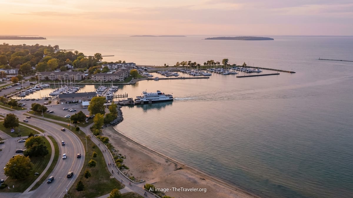
Ferry travel is at the heart of the Lake Erie Shores & Islands experience. Several operators run regular services that connect the mainland with South Bass Island, Middle Bass Island, and Kelleys Island, typically from late spring through fall and in some cases nearly year round as lake conditions allow. Passenger only high speed catamarans focus on speed and convenience, while traditional ferries accommodate both foot passengers and vehicles, including bikes and golf carts.
From downtown Sandusky and Port Clinton, a passenger only operator offers frequent sailings to Put in Bay and seasonal connections to Kelleys Island. These high speed boats are designed with enclosed cabins and open air decks so you can choose between shelter and fresh air. The trip to Put in Bay is typically under an hour, often less, and some schedules include brief stops at Cedar Point Marina. Because departures can vary with weather and demand, it is wise to consult the latest timetable shortly before your trip and to arrive at the dock with time to spare during summer weekends.
For travelers bringing a car, motorcycle, or loaded bicycles, the auto ferries based near Marblehead and Catawba Island are the primary link. These vessels make short crossings that usually take around twenty minutes, with rolling departures throughout the day in peak season. Even if you plan to cross without a vehicle, the auto ferries can be a pleasant choice, as the open decks and slower pace provide a classic maritime feel. When the lake is choppy, schedules may be adjusted or crossings temporarily suspended, so flexibility is important.
Water taxi style services add another layer of connectivity. In Erie, Pennsylvania, a seasonal water taxi connects downtown docks with Presque Isle State Park, carrying pedestrians and cyclists across Presque Isle Bay. On the Ohio islands themselves, harbor shuttles and smaller boats often move people between moorings, marinas, and waterfront attractions. These short hops can be an efficient way to link walking and biking routes or to enjoy a scenic detour at sunset.
Getting Around Once You Are on the Islands
Once you step off the ferry, transportation on the islands becomes refreshingly low key. Distances on South Bass Island and Kelleys Island are modest, and many visitors are content to walk between docks, lodging, and waterfront restaurants, especially in the core of Put in Bay village. Sidewalks and compact streets lend themselves to strolling, although weekends and festival days can be busy with golf cart and bike traffic.
Golf carts are the signature way to move around the islands. Numerous rental outfits operate near ferry docks and in village centers, offering vehicles by the hour, day, or longer. Standard carts typically seat four passengers, with larger models available for families or groups. Basic driving rules apply, and renters must usually carry a valid driver’s license. Because carts share the road with cars, bikes, and pedestrians, it is important to drive defensively, obey posted speed limits, and avoid traveling after dark if you are unfamiliar with the roads.
Bikes offer a quieter and more immersive way to explore. Gentle roads and scenic loops around Kelleys Island and South Bass Island reward patient pedaling, and several bike rental shops cluster near docks for both conventional and electric assist bikes. Helmets are strongly encouraged, and riders should be prepared for variable pavement, occasional gravel, and narrow shoulders on some stretches. Early morning and late afternoon can be especially pleasant times to ride, when traffic is lighter and the light over the lake is soft.
Additional options range from taxis and small shuttle vans to seasonal tram tours that circle attractions on peak days. While you can sometimes hail these on the spot, availability is not guaranteed, so do not depend on them for tight connections. Instead, treat them as a bonus convenience and build a plan that works on foot, by bike, or with a prearranged golf cart rental. Remember that the islands are small enough that getting a little lost often leads to unexpected lake views, historic sites, or quiet beaches.
Mainland Transit, Rail, and Rideshares
Although most visitors arrive by car, it is possible to explore Lake Erie Shores & Islands with limited driving or even without a personal vehicle. Sandusky functions as a key transportation hub, with passenger rail, intercity buses, and a local transit system that circles the city and serves major corridors. These services can be especially useful for travelers who arrive overnight by train or bus and then need to reach a hotel, ferry terminal, or amusement park without renting a car.
Amtrak trains connect Sandusky with larger cities to the east and west, though most arrivals and departures occur during late night or early morning hours. The station often shares space with an intercity bus stop, allowing onward connections by coach to other Ohio communities. From there, local buses operated by the Sandusky Transit System run daytime routes linking downtown, shopping areas, and some resort zones. Schedules can be modest, so plan around published timetables and expect longer waits outside peak commuting periods.
Rideshare services and traditional taxis fill gaps between fixed route services, particularly for point to point trips between hotels, ferry docks, and attractions like Cedar Point. Availability tends to be highest in summer and on weekends when visitor numbers are strong. Because surge pricing can apply during major events or late at night, it is wise to check estimated fares in advance and consider walking or using a local shuttle when distances are short and weather is favorable.
In the broader region, Cleveland and Toledo provide additional transport anchors. Cleveland’s airport, local rail lines, and bus network offer options for passengers arriving by air and continuing toward the lakeshore. From these cities, travelers typically rent a car or board a regional bus to reach coastal towns. While pure transit only trips are possible, they often involve multiple transfers and limited service windows, so they suit patient travelers who are comfortable reading timetables and adjusting on the fly.
Active Travel: Walking, Bicycling, and Trails
The Lake Erie shoreline rewards travelers who slow down to explore on foot or by bicycle. Many communities maintain waterfront paths, boardwalks, and lakefront promenades that link marinas, beaches, and historic districts. These routes offer safe, scenic corridors that can substitute for short car journeys, especially in good weather. Comfortable shoes and a light daypack often prove more useful than a car key when you base yourself in a walkable lake town.
Cyclists will find a growing network of bike routes and shared use paths in the region. Around Cleveland, the Cleveland Metroparks system and lakefront trails provide long, mostly flat rides with views of both the lake and city skyline. Further west, quiet county roads near Marblehead, Port Clinton, and Vermilion lead through farms, marshes, and small harbors. On the islands, loops around Kelleys Island and South Bass Island are popular day rides, with frequent opportunities to break for swimming, birdwatching, or a picnic.
Bike rentals are widely available in island villages and in some mainland towns such as Sandusky and Lakeside, where outdoor outfitters and rental shops supply cruisers, hybrids, and increasingly, electric assist models. When renting, ask about local etiquette, safe routes for families, and any steep or busy sections you may want to avoid. A small basket or pannier for water and snacks, along with a basic lock, will make spontaneous stops much easier.
Walkers should remember that the sun reflecting off the lake can intensify heat, even on days that feel mild. Carrying water, wearing a hat, and respecting distance are important, particularly if you decide to link multiple sights on foot. Fortunately, many trails have shaded portions and frequent access to restrooms, playgrounds, and cafes. Planning a loose circuit that brings you back to your starting point via a different street or shoreline segment can turn a simple transfer into a memorable walking tour.
Boat Owners, Marinas, and Scenic Cruises
For travelers arriving with their own boat, the Lake Erie Shores & Islands region offers a mix of public marinas, private yacht clubs, and transient slips. Advance reservations are strongly recommended during summer weekends and holiday periods, when harbor space is at a premium. Many marinas provide fuel, pump out services, restrooms, and showers, along with nearby restaurants and shops. Some also lie within walking distance of ferry docks, bike rentals, and island attractions, making it easy to combine cruising with onshore exploration.
Boaters should monitor local marine forecasts closely, as Lake Erie’s relatively shallow waters can produce choppy conditions when winds shift. Travel plans that look straightforward on a calm morning can become impractical if storms build or visibility drops. Carrying appropriate safety gear, filing a float plan with someone on shore, and building flexibility into your schedule all help manage the lake’s changeable personality. Local harbor masters and marina staff are excellent sources of current information on shoaling, navigation markers, and busy times on the water.
If you do not own a boat but want time on the lake, sightseeing cruises and charter outings are widely available in peak season. Options range from narrated lighthouse and history cruises to sunset trips featuring local food or live music. A number of operators run themed excursions that highlight natural features, historic wine cellars, or seasonal events. These cruises can be an effortless way to cover distance, learn context, and capture wide water views without worrying about navigation or docking.
Some visitors choose to pair a cruise with other transportation modes on the same day. For instance, you might bike along a lakefront trail in the morning, board a short lighthouse cruise in the afternoon, and return to your lodging via a trolley or rideshare in the evening. Treating transportation itself as an activity, rather than simply a means to an end, can transform your time in the region.
Planning Tips for Smooth Connections
Success in getting around Lake Erie Shores & Islands usually comes down to timing, flexibility, and communication. Ferry and water taxi schedules are seasonal and can change from year to year, so rely on the most up to date information shortly before you travel rather than assuming past timetables still apply. Booking tickets in advance for popular departure times can ease wait times, especially on holiday weekends or during large island events.
Weather is a decisive factor on the water. Strong winds, reduced visibility, or thunderstorms can slow crossings or temporarily pause service. Building a cushion into your schedule, such as arriving a ferry or two earlier than strictly necessary for a connecting event, reduces stress if there are delays. Having a backup plan, like exploring a mainland town, visiting a nearby state park, or shifting to a later ferry, can keep the day enjoyable even if conditions change.
Parking arrangements and hotel locations also shape transportation choices. Lodging within walking distance of a dock or in the core of a village may allow you to ignore your car for days at a time. Conversely, if you stay farther inland to save on accommodations, you will need to account for drive times, potential traffic around major attractions, and daily parking fees. Clarify hotel shuttle options in advance, since not all properties offer transportation to ferry terminals or amusement parks, and policies can vary.
Finally, pack with mobility in mind. Rolling luggage and compact backpacks are easier to maneuver on ferry ramps, cobbled streets, and bike baskets than large hard sided suitcases. Weather appropriate layers, a light rain shell, and secure storage for phones and small valuables will make it easier to adapt as you transition between car, ferry, bike, and foot. With a little preparation, the movement between modes can become one of the highlights of your Lake Erie adventure.
FAQ
Q1. Do I need a car to explore Lake Erie Shores & Islands?
You can visit without a car if you combine trains or buses to Sandusky with ferries, bikes, golf carts, and walking. However, a car gives more flexibility for visiting multiple mainland towns or rural attractions.
Q2. How early should I arrive for a Lake Erie island ferry?
In peak summer, aim to arrive at least 30 to 60 minutes before departure, especially on weekends or holidays. Shoulder seasons are often less crowded, but earlier is still better than cutting it close.
Q3. Can I take my car to Put in Bay or Kelleys Island?
Yes, auto ferries carry vehicles to South Bass Island and Kelleys Island, but many visitors leave their cars on the mainland and travel as foot passengers, then rent a golf cart or bike on arrival.
Q4. What is the best way to get around once I am on the islands?
Golf carts and bicycles are the most popular options, supported by walking for short distances in village centers. Taxis and seasonal shuttles are available in limited numbers for specific trips or groups.
Q5. Are there public transportation options from Sandusky to ferry docks?
Local buses and taxis serve parts of Sandusky, and some routes or services pass near waterfront areas. Many travelers, however, use rideshares or walk from downtown accommodations to nearby docks.
Q6. What happens if the weather is bad on Lake Erie?
In rough conditions, ferry operators may adjust schedules, slow crossings, or temporarily suspend service. Always check for updates on the day of travel and be prepared to adjust your plans.
Q7. Is cycling safe around Lake Erie Shores & Islands?
Cycling is common and generally safe when riders follow traffic rules, wear helmets, and choose appropriate routes. Shared use trails and quieter roads are usually better for families than busy highways.
Q8. Can I visit multiple islands in one day?
Visiting more than one island in a day is possible when schedules align, but it can feel rushed. Many travelers prefer to dedicate at least a full day to each island to explore at a relaxed pace.
Q9. Are there accessible transportation options for travelers with mobility needs?
Many ferries, some buses, and a portion of golf cart fleets provide accessible features, but availability varies. It is best to contact operators ahead of time to confirm ramps, lifts, or adapted vehicles.
Q10. When is the easiest time of year to get around the region?
Late spring and early fall often balance good weather with lighter crowds and more relaxed ferry boarding. Summer offers the most frequent services but also the greatest demand, especially on weekends.