
More news on this day
A little-known gravel track along the Canada–U.S. boundary in southern Alberta and northern Montana is emerging as a flashpoint in border policy, as a recent American decision to bar Canadians from the so-called Border Road effectively ends an 80-year tradition of unfenced, everyday connection between neighboring prairie communities.
Get the latest news straight to your inbox!
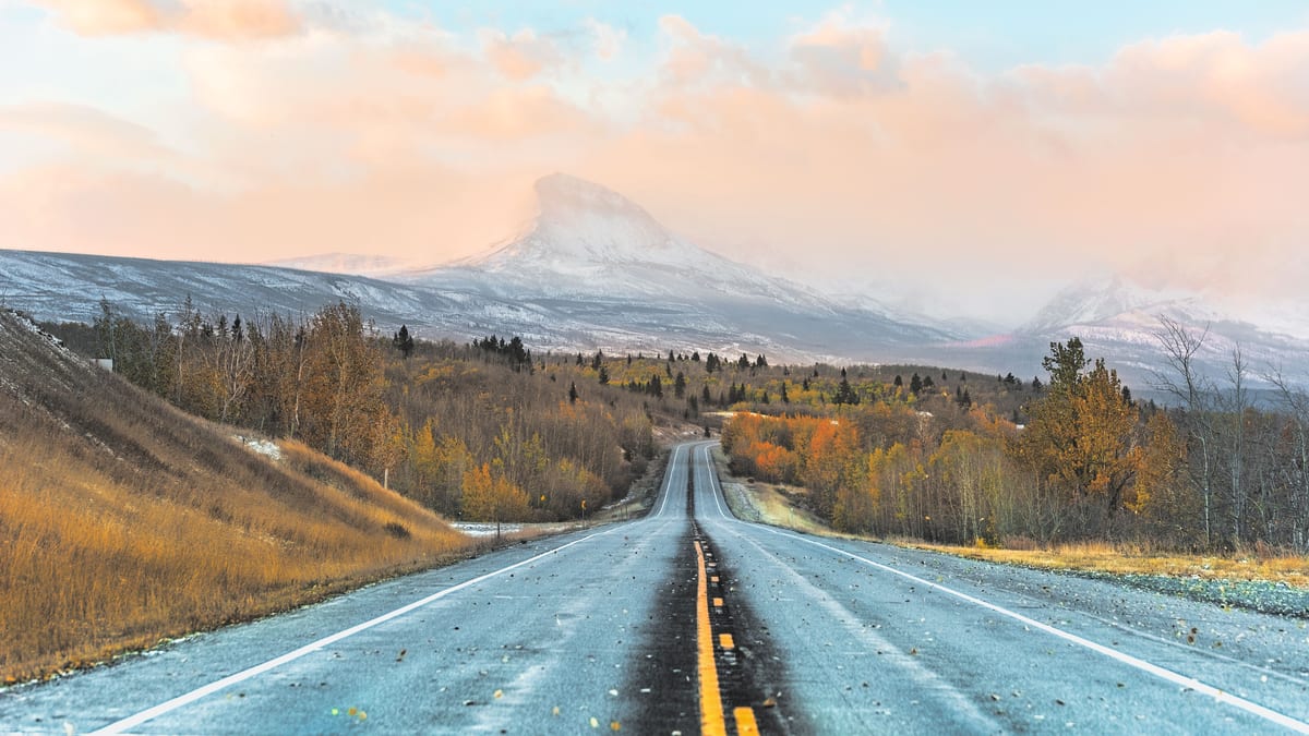
Image by TheTravel
A Quiet Farm Road With Outsized Emotional Weight
Known locally simply as Border Road, the east west route traces the international boundary in a sparsely populated stretch between Alberta and Montana, serving as a practical shortcut for ranchers, farm workers, and families who live and work on both sides. Publicly available mapping and local reporting indicate that the road technically lies inside Montana, hugging the 49th parallel while tying into a web of rural concession roads in Alberta.
For decades, residents treated the route as part of a single landscape rather than two countries. Reports from regional news outlets and community forums describe Canadians using the American road to move farm equipment, visit neighbors, attend social events, and access services in nearby Montana towns, often without ever passing through a formal land port of entry.
The road’s origins are linked to mid twentieth century efforts to delineate and service the Prairie segment of the international boundary. Historical research on the Canada U.S. line notes that survey plans for Manitoba, Saskatchewan, and Alberta included a dedicated road allowance along the border, creating a patchwork of section line roads that, over time, evolved into informal cross border connectors in agricultural districts.
While most cross border traffic today funnels through staffed checkpoints like Coutts Sweetgrass, Border Road remained an anomaly from an earlier era. Locals in southern Alberta and northern Montana often describe it in media interviews and public comments as a shared rural space, less a crossing point than a common back lane that symbolized long standing social and economic bonds.
Security Concerns Drive a New Hard Line
That low key arrangement is now being dismantled. Recent coverage by Canadian and U.S. regional outlets reports that the U.S. Department of Homeland Security has moved to end Canadian access to the road, citing broader security priorities along the northern frontier and a desire to channel all cross border movement through staffed ports of entry.
Border policy experts point out that the decision fits into a wider continental pattern. Over the past decade, authorities on both sides have tightened control over so called irregular or informal routes, whether small dead end roads in Quebec and New York or lightly monitored tracks in the Prairies and northern Plains. High profile attention to unauthorized crossings, combined with evolving migration pressures and contraband concerns, has led to a more literal interpretation of where and how international borders should be crossed.
Publicly available statements from American border agencies emphasize a need for clear lines of sight, predictable traffic patterns, and rapid response capability in rural sectors that are difficult to patrol. From that vantage point, a lightly traveled road physically in the United States but functionally serving Canadian farmers presents an operational challenge, even if local traffic has historically posed little risk.
Analysts also note that the decision comes as encounters between ports of entry along portions of the northern border have risen in recent reporting periods. While most of those encounters are documented in eastern regions, the policy response tends to be national in scope, with measures applied uniformly along the international line rather than tailored to specific local conditions.
Local Communities Confront Disrupted Routines
The practical implications of the Border Road closure for nearby residents are immediate. Reports from southern Alberta suggest that farm operators who once used the road to move machinery in a straight line along the boundary will now need to detour through official crossings, adding distance, time, and potential logistical hurdles during tight seeding and harvest windows.
On the Montana side, ranch families with relatives in Alberta face a similar recalibration of everyday life. What had been a casual drive down a familiar gravel route to see friends or attend community events will instead require careful coordination with port hours, identification documents, and international travel rules that feel out of step with the region’s intertwined history.
Regional coverage indicates that some residents are particularly concerned about emergency access. In a landscape where winter storms, prairie wildfires, and medical incidents can quickly become life threatening, the ability to take the most direct available route often matters more than which jurisdiction maintains the gravel. With Border Road effectively off limits to Canadians, some cross border trips that once took minutes may now extend to an hour or more.
Officials in Alberta have publicly indicated plans to design a replacement route fully on the Canadian side, intended to preserve local connectivity without infringing on American security prerogatives. However, any new construction will require funding, land agreements, and environmental review, meaning residents are likely to face a period of reduced access in the near term.
Tourism, Trade, and the Symbolism of a Line
At first glance, the closure of a little used gravel road might seem marginal alongside billion dollar trade flows and major highway crossings between Alberta and Montana. Yet tourism analysts and regional economists argue that such decisions can carry disproportionate symbolic weight, especially at a time when cross border leisure travel and shopping trips have already softened in parts of the Prairies and northern Plains.
Pre pandemic and early 2020s data from provincial and state agencies frame Alberta Montana ties as a microcosm of the wider Canada U.S. economic relationship, blending energy trade, agriculture, trucking, and tourism. Even incremental frictions in the travel experience such as added distance or perceived scrutiny can influence whether families choose to cross the border for a weekend, a sporting event, or a small town festival.
Border scholars describe roads like the Alberta Montana Border Road as tangible expressions of what has often been called the world’s longest undefended border. In that context, closing the Canadian side of access to an 80 year old shared route feels, to many residents, like the end of a gentler chapter in bilateral relations, even if formal trade and diplomatic ties remain strong.
The shift also underscores how security logics tend to privilege controlled gateways over diffuse, informal ties. Where earlier generations might have read the absence of fences as a sign of trust, contemporary policy increasingly reads unmonitored space as vulnerability. The fate of Border Road is one small but vivid example of that conceptual change etched into the landscape.
A Test Case for Balancing Security and Everyday Life
As the closure timeline approaches, attention is turning to how governments at multiple levels will balance national security priorities against the lived realities of borderland communities. Public discussions in Alberta municipal councils and Montana county meetings suggest that residents are not necessarily disputing the importance of secure borders, but are asking that policy be shaped with local geography and history in mind.
Some cross border researchers see the episode as a potential test case for collaborative solutions, such as jointly planned replacement roads, enhanced infrastructure at nearby official crossings, or targeted exemptions that recognize the unique nature of agricultural work. Others caution that once long standing informal arrangements are revoked, they are rarely restored in their original form.
What seems clear is that the closure of Canadian access to this modest prairie road marks more than a cartographic adjustment. For families who have navigated back and forth along the 49th parallel for generations, the change represents a redefinition of what it means to live in a border community, where an invisible line is becoming a more tangible, and sometimes less forgiving, reality.