
More news on this day
A volatile March storm pattern is driving a new wave of tornado warnings across the United States, with Illinois at the center of a high-impact severe weather threat that forecasters warn could bring destructive twisters, flying debris and widespread damage through March 16.
Get the latest news straight to your inbox!
Unstable National Pattern Fuels Another Tornado Surge
Meteorological outlooks for mid-March 2026 point to an unusually active clash of seasons, with cold air from a renewed polar surge colliding with early spring warmth and Gulf moisture over the central United States. Publicly available forecasts describe a sprawling storm system sweeping from the Plains into the Midwest and Great Lakes, primed to produce severe thunderstorms capable of damaging winds, large hail and multiple tornadoes.
Recent summaries of 2026 tornado activity indicate that the month has already featured more than one organized outbreak, with strong supercells affecting portions of Oklahoma, Michigan and the broader Midwestern corridor. That backdrop has heightened concern among forecasters and emergency planners that today’s evolving system could prolong a volatile stretch of weather across several regions rather than a single, isolated event.
The broader national picture adds to the sense of instability. Separate reporting on the March weather pattern notes that other parts of the country are also dealing with extremes, from heavy snow in the northern tier to early-season heat building in the Southwest. For travelers, it means conditions can change quickly over relatively short distances, and routes that were safe earlier in the day may lie in the path of dangerous storms by nightfall.
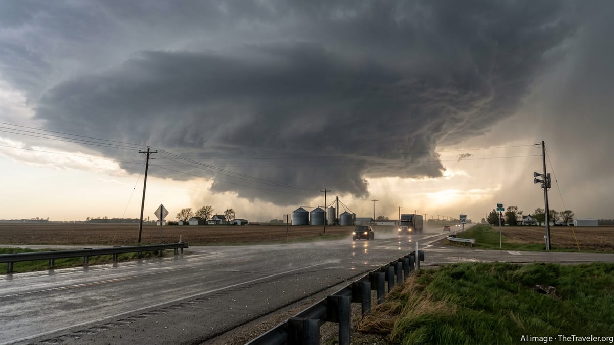
Illinois Under Heightened Tornado and Flying Debris Risk
Within this complex setup, Illinois stands out as a key focus area for severe weather through March 16, with storm prediction outlooks highlighting a corridor of elevated tornado potential across central and northern sections of the state. Radar-based discussions and real-time commentary shared by weather monitoring communities on March 15 and 16 describe repeated tornado warnings, including for fast-moving cells capable of producing sudden spin-ups and damaging straight-line winds.
In recent days, Illinois has already experienced the destructive side of this pattern. Published coverage earlier in the week documented tornadoes that leveled buildings in and around Kankakee and nearby communities, with images of splintered homes, mangled vehicles and snapped power poles underscoring the threat posed by even brief touchdowns. Social media posts from storm-spotting networks have referenced large, sometimes multi-vortex tornadoes in this same general corridor, along with accounts of baseball-sized hail and severe structural damage.
As new storms develop, forecasters warn that flying debris remains a particular danger. Even relatively modest tornadoes or intense straight-line gusts can loft roofing material, tree limbs and unsecured outdoor objects, turning them into high-speed projectiles. For residents, that raises the stakes around sheltering inside sturdy interior rooms away from windows. For visitors on the road, it reinforces guidance to avoid seeking refuge in vehicles or under overpasses when warnings are issued.
Travel and Infrastructure Disruptions Across the Midwest
The unfolding severe weather wave carries significant implications for transportation in and around Illinois, a critical crossroads for interstate highways, regional rail and Midwest air traffic. Reports from earlier tornado days this month noted temporary closures of local roads due to downed trees, power lines and scattered debris fields, as well as localized power outages that darkened traffic signals and complicated navigation after dark.
Similar disruptions are possible again as new storms move across the state. Low visibility from intense rain and hail, coupled with sudden wind shifts near rotating thunderstorms, can create hazardous driving conditions in a matter of minutes. In past events this month, online community reports from cities such as Peoria and Springfield have highlighted rapidly changing skies, sirens sounding, and warnings encouraging people to stay off the roads during peak storm windows.
Rail and air operations are also sensitive to this type of weather. While major carriers publish their own alerts, travelers can anticipate possible delays if strong storms pass near key hubs, prompting ground stops, diversions or temporary suspensions of service for lightning and wind. On the ground, the combination of power interruptions, damaged signage and scattered debris can make wayfinding more difficult for visitors unfamiliar with local routes.
Safety Guidance for Residents and Visitors in Illinois
Public safety agencies and weather outreach campaigns in Illinois have long emphasized the importance of severe weather preparedness, particularly in March, which state guidance designates as Severe Weather Preparedness Month. Educational materials circulated by state emergency management and National Weather Service offices stress that when a tornado warning is issued, people should move quickly to a small, windowless interior room on the lowest floor of a sturdy building, avoiding vehicles and mobile homes when at all possible.
For travelers, the advice is even more specific. Preparedness documents note that cars and trucks offer limited protection from tornado-strength winds and flying debris. Instead of attempting to “outrun” a storm along busy interstate corridors, visitors are encouraged to identify nearby substantial buildings such as rest areas, hotels or public facilities where they can shelter if a warning is issued for their immediate location. Having a charged mobile device with wireless alerts enabled, along with a flashlight and basic emergency kit, can be particularly helpful on long road trips through the region.
Hotel guests and short-term renters in Illinois are also encouraged to familiarize themselves with building emergency plans, interior stairwells and lower-level refuge areas. Guidance from previous severe weather campaigns recommends asking front-desk staff where guests should go during tornado warnings and reviewing those routes in advance, before storms arrive after dark. For international and out-of-state visitors less familiar with sirens or alert terminology, taking a few minutes to understand local warning systems can provide crucial clarity amid a fast-moving situation.
What Travelers Should Expect in the Coming Days
Looking ahead through March 16, forecast discussions for the broader storm complex point to continued severe weather chances shifting east and southeast of Illinois, but with lingering risk for strong thunderstorms and additional tornado warnings along and just ahead of the cold front. That means travelers planning to cross the Midwest into the Ohio Valley, the Lower Mississippi Valley or the Mid-Atlantic may encounter new rounds of hazardous weather, even as conditions gradually improve behind the system.
Weather outlooks also suggest that the current turbulent pattern may not mark the end of March storminess, especially as stronger springtime systems typically become more common later in the month. For the travel sector, that raises the likelihood of recurring delays and short-notice schedule changes, particularly on peak days when thunderstorms line up along major flight corridors or sweep across multiple interstate junctions at once.
Against that backdrop, travel and risk experts generally recommend building flexibility into plans during active severe weather periods. Keeping overnight options open along long-distance routes, monitoring updated forecasts throughout the day, and allowing extra time for detours around storm-damaged areas can all reduce stress when warnings are issued. For now, Illinois remains one of the focal points of this latest wave of tornado risk, and both residents and visitors are being urged through public channels to stay weather-aware as the storms continue to unfold.