
More news on this day
Vancouver and the broader South Coast of British Columbia are preparing for a powerful atmospheric river expected to bring intense rainfall, rapid snowmelt and a heightened risk of flooding and landslides in the coming days, according to recent forecasts and government bulletins.
Get the latest news straight to your inbox!
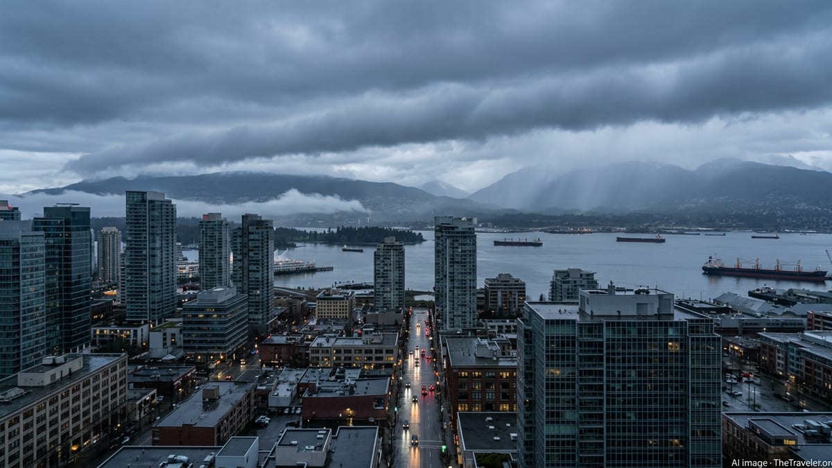
Historic Moisture Plume Targets the South Coast
Forecast discussions and federal and provincial bulletins point to a concentrated plume of Pacific moisture setting up over the South Coast, including Metro Vancouver, through early this week. An atmospheric river is a narrow corridor of water vapour in the sky, capable of delivering several months’ worth of rain in just a few days when it stalls over coastal terrain.
Recent updates from the BC River Forecast Centre describe a sequence of storms feeding into this river of moisture, with rainfall totals for coastal British Columbia projected in the tens to potentially over one hundred millimetres in some exposed locations. Similar events in December 2025 and in past autumn and winter seasons produced rapid river rises, localized flooding and drainage systems pushed beyond capacity across southwestern British Columbia.
Publicly available outlooks for the ongoing 2025–26 winter indicate an active storm track pointed at the Pacific Northwest, with a separate long-duration atmospheric river already impacting Washington and Oregon. As that conveyor of moisture shifts northward, model guidance suggests the core of heavy rain and snowmelt will increasingly focus on Vancouver Island, the Sunshine Coast and the Metro Vancouver area.
Travelers heading to or through Vancouver in the next several days are being advised by local media and weather services to anticipate periods of torrential rain, low cloud and gusty winds, particularly on approach and departure at Vancouver International Airport and along ferry routes linking the mainland and Vancouver Island.
Flooding Risk Heightened by Rain-on-Snow
While heavy rain alone can strain urban drainage systems, forecasters are signaling particular concern about the combination of warm, moisture-laden air and a relatively low but vulnerable mid-elevation snowpack on surrounding mountains. Recent provincial snow surveys for March show below-normal snow in parts of the South Coast and Vancouver Island, but note that rapid melting during strong storms can still create significant runoff when paired with intense rain.
River Forecast Centre advisories issued earlier this season for the Coast, Vancouver Island and Lower Fraser watersheds highlighted the potential for 5-year to 10-year flow levels in some rivers under strong atmospheric river conditions. Those bulletins described localized high flows, swiftwater hazards, and an increased likelihood of road washouts where culverts or bridge approaches become overwhelmed, particularly in narrow valleys and along smaller creeks.
In Metro Vancouver itself, the greatest immediate threat is often urban flooding. Prolonged downpours can clog storm drains with debris and leaves, leading to large puddles and standing water at intersections, underpasses and low-lying neighbourhoods. Previous atmospheric river episodes in 2024 and 2025 brought scenes of flooded basements, overwhelmed pump stations and impassable side streets, even where larger rivers stayed within their banks.
Communities in the Fraser Valley, including Chilliwack and Abbotsford, as well as coastal lowlands from Delta and Richmond through Surrey and Langley, remain especially sensitive to back-to-back rainfall events. Published coverage of recent B.C. flood seasons notes that saturated ground conditions and ongoing riverbank erosion can amplify the impact of each new storm, increasing the risk of dike seepage, overland flow and groundwater intrusion.
Landslide and Transportation Disruption Concerns
The mountains and steep-sided inlets that define Vancouver’s dramatic setting also magnify the danger of landslides during major rain events. Atmospheric rivers in 2021 and again in 2024 triggered debris flows, rockfalls and mudslides across southwestern British Columbia, temporarily severing key road and rail corridors and closing popular hiking areas. Government post-event reports from those storms cited intense rainfall on unstable slopes, as well as logging roads and wildfire-scarred hillsides, as critical contributing factors.
Highways that connect Metro Vancouver to the Interior and to Vancouver Island are especially vulnerable in this type of pattern. Sections of Highway 1 through the Fraser Canyon, Highway 99 between Squamish and Pemberton, and Highway 4 on Vancouver Island have previously seen lane closures, single-lane alternating traffic or full shutdowns due to slope failures and washouts following extreme rainfall. BC Ferries and regional transit systems can also experience delays when strong winds and low visibility accompany heavy rain.
For visitors, the timing of this atmospheric river could translate into disrupted itineraries, longer travel times and sudden changes to outdoor plans. Day trips to popular destinations such as the North Shore mountains, Whistler, Squamish and Tofino may be affected by temporary road closures or advisories against non-essential travel if rainfall and runoff intensify. Tourism operators across the South Coast have become accustomed to monitoring these events closely, often shifting bookings, routes or activities based on evolving conditions.
Aviation and marine forecasts are additionally flagging periods of turbulence, low ceilings and rough seas. While scheduled services typically continue through heavy rain, travelers are being urged through local media and airline alerts to build extra time into their connections and be prepared for delays, diversions or cancellations if conditions deteriorate.
How Residents and Travelers Can Prepare Now
With the most intense rainfall expected over a relatively short window, regional preparedness efforts are focusing on simple, practical steps that can significantly reduce the impact of flooding and landslides. Municipal communications in past storms have emphasized clearing leaves and debris from street drains, checking sump pumps, and moving valuables and electronics off basement floors ahead of peak rainfall periods.
For people in known floodplains or near creeks, publicly available guidance from provincial and municipal resources points to having an emergency kit ready, knowing local evacuation routes, and planning where to park vehicles away from low spots or unstable slopes. Homeowners along steep ravines or at the base of hills are also encouraged in official materials to watch for signs of slope movement such as new cracks, tilting trees or unusual ground seepage during prolonged heavy rain.
Visitors staying in Vancouver hotels, short-term rentals or campgrounds can prepare by closely checking weather forecasts, asking accommodation providers about local risks, and identifying alternative routes if a primary highway or transit line is affected. Travel advisories from provincial agencies, airport operators and ferry services are typically updated frequently during major storms, and media outlets across the region provide round-the-clock coverage when conditions deteriorate.
Outdoor enthusiasts may need to rethink planned hikes, backcountry trips or coastal excursions while the atmospheric river is in place. Avalanche bulletins, trail status reports and park advisories often shift rapidly during these events as heavy rain destabilizes snowpacks and saturates soils. Public information from parks agencies and search-and-rescue organizations repeatedly stresses that swollen creeks, slippery slopes and falling rock can turn routine outings into emergencies during extreme rain.
Climate Context and What Comes Next
Researchers and government assessments increasingly link the severity of recent Pacific Northwest flood events to a warming climate that can hold and transport more moisture. Studies and official summaries following the 2021 and 2024 British Columbia floods noted that a warmer atmosphere intensifies atmospheric rivers by allowing them to carry greater amounts of water vapour, increasing the odds of record-breaking rainfall when they intersect with coastal mountains.
While not every atmospheric river becomes a historic disaster, the clustering of events in recent seasons has prompted renewed attention to long-term resilience in and around Vancouver. Infrastructure upgrades to dikes, pump stations and stormwater networks, along with updated land-use plans that account for landslide and flood hazards, are increasingly highlighted in policy documents and regional planning discussions.
For residents and travelers alike, the immediate concern is navigating the coming days safely. Reports indicate that forecasters will continue to refine projected rainfall totals, snowmelt contributions and river levels as the event unfolds, updating advisories and watches accordingly. Observers across the South Coast will be watching closely to see whether this atmospheric river meets early warnings as a historic benchmark or simply reinforces the message that extreme rain is an increasingly familiar part of life on Canada’s Pacific edge.
As the system approaches, travel and weather experts encourage anyone with upcoming plans in Metro Vancouver, Vancouver Island or the Fraser Valley to stay alert to changing forecasts, local advisories and on-the-ground reports. Quick action before the heaviest rain arrives can make the difference between a disruptive storm and one that becomes truly damaging.