
More news on this day
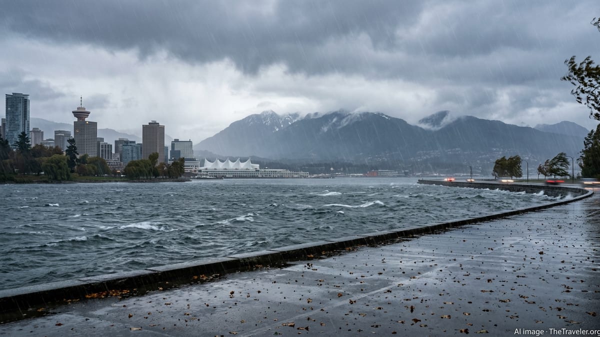
Vancouver and communities across British Columbia’s South Coast are bracing for a powerful atmospheric river expected to unleash intense rainfall, trigger flooding and landslides, and significantly disrupt travel in the coming days.
Get the latest news straight to your inbox!
Forecast Points to Unusually Intense Pacific Storm Pipeline
Publicly available meteorological outlooks describe a strong, moisture-laden atmospheric river aimed at the Pacific Northwest, with the plume of subtropical Pacific moisture forecast to intersect coastal British Columbia. Analysis from research centers that specialize in atmospheric rivers indicates that similar events can deliver several days of near-continuous heavy rain, with the most severe impacts often occurring along windward mountain slopes and already saturated lowlands.
Regional bulletins and recent seasonal assessments for British Columbia highlight a heightened sensitivity to heavy rain because of variable snowpack and a series of earlier storms. When warm, rain-heavy systems move over existing snow in nearby watersheds, rapid snowmelt can combine with runoff to push rivers and creeks higher, increasing the likelihood of flooding. Coastal cities such as Vancouver, with dense development and extensive paved surfaces, are particularly vulnerable to intense short-duration downpours that overwhelm drainage.
In past years, atmospheric river episodes have produced some of the most damaging flood events in the Pacific Northwest, with multiday rainfall totals that ranked among the highest on record in some basins. Current projections suggest that the approaching system could fall into the stronger range of these events, raising concern that localized records for March rainfall might be challenged in parts of the South Coast if the heaviest rain bands stall over the region.
Flooding, Landslides, and Power Outages Expected Across the South Coast
Reports from recent storm seasons in British Columbia describe how similar setups have led to swollen rivers, rapid rises in small creeks, and widespread surface flooding in low-lying neighborhoods. Even where rivers remained below major flood thresholds, pooling water on roads created hazardous driving conditions, particularly overnight and during peak commuting hours. In some communities, basements flooded and stormwater systems backed up under the strain.
The steep terrain that frames Metro Vancouver and the Sea-to-Sky corridor is highly susceptible to landslides once soils become saturated. Historic atmospheric river events in the region have triggered debris flows that buried stretches of highway, isolated communities, and forced extended closures on key mountain routes. With another prolonged burst of heavy rain in the forecast, the risk of slope failures on cut banks, forested hillsides, and road embankments is expected to increase through the event.
Storm-related power outages are also a concern. Previous Pacific storms combining strong winds with heavy rain brought down trees and power lines around the Lower Mainland and Vancouver Island, in some cases leaving tens of thousands of customers without electricity. With soils loosened by repeated rainfall, even moderate gusts can be enough to topple shallow-rooted trees in parks, along streets, and beside transmission corridors.
Travel Disruption Likely for Road, Air, and Ferry Passengers
Published coverage of earlier atmospheric river episodes in British Columbia shows a consistent pattern of major transportation disruption when intense rain coincides with high winds and poor visibility. Drivers on Highway 1 through the Fraser Valley, Highway 99 along the Sea-to-Sky corridor, and key Vancouver Island routes have previously faced rockfalls, localized flooding, and temporary closures while maintenance crews worked to clear debris and assess slope stability.
Air travelers to and from Vancouver International Airport can expect the possibility of delays if low cloud ceilings, strong crosswinds, or reduced runway visibility develop during the heaviest bands of rain. While airports in the region are accustomed to wet conditions, a combination of saturated runways, wind shear, and lightning in embedded convective cells sometimes leads to flight schedule adjustments, diversions, or missed connections for passengers.
Ferry services across the Strait of Georgia and to smaller Gulf Islands may also be affected. Historical storm reports detail instances in which strong southeast winds, rough seas, and poor visibility forced schedule changes or cancellations on major coastal routes. With an incoming storm track aligned to funnel energy directly into exposed channels, travelers are being advised through public messaging to monitor service notices closely and build extra flexibility into their plans.
How Residents and Visitors Can Prepare Right Now
Emergency management guidance for British Columbia consistently emphasizes early preparation in advance of significant rain events. Recommended actions include clearing leaves and debris from gutters, downspouts, driveway drains, and street storm grates so that heavy runoff can flow more freely. Property owners in known flood-prone areas are encouraged to move valuables off basement floors, check sump pumps, and review sandbag options where municipal programs exist.
Travelers and residents are urged by publicly available preparedness resources to assemble or refresh basic emergency kits with flashlights, batteries, drinking water, non-perishable food, medications, and backup power for mobile devices. Experience from past storms in the region shows that even short-duration power outages can become disruptive when combined with localized flooding or blocked roads, especially for those relying on electrically powered medical devices or refrigeration.
Those living near steep slopes, creek banks, or past landslide sites are advised in official preparedness materials to stay alert for signs of instability, such as sudden cracks in soil, new tilting of trees or utility poles, or unusual sounds like rumbling or snapping during and after intense rainfall. Regional guidance notes that if residents feel unsafe because of changing ground conditions, leaving the area early is often the safest option, rather than waiting for visible movement of debris.
What This Means for Travelers Planning a Trip to Vancouver
For visitors heading to Vancouver in the coming days, the incoming atmospheric river does not mean travel must be cancelled outright, but it does call for flexibility and caution. Tourism trends and past storm seasons show that city attractions often remain open during heavy rain, though outdoor activities such as coastal hikes, mountain viewpoints, and forest trails may be unsafe or temporarily closed due to windfall and landslide risk. Urban experiences, museums, restaurants, and cultural venues typically remain more resilient to severe weather.
Travel planners suggest monitoring airline, rail, highway, and ferry updates frequently during the event window, especially for itineraries that involve connections through mountain passes or exposed marine crossings. Building buffer time between legs of a journey, considering travel insurance that covers weather-related disruption, and keeping alternative plans in mind can reduce stress if conditions deteriorate.
For those already in the city, adapting plans to the weather is key. Well-known waterfronts, seawalls, and riverfront paths may experience elevated water levels, strong winds, and pounding surf, and access restrictions are sometimes put in place for public safety. Visitors are encouraged through municipal advisories and tourism bulletins to respect any temporary closures, keep a safe distance from shorelines during high tide and storm surge periods, and opt for indoor or more sheltered activities until the heaviest rain and wind have passed.