
More news on this day
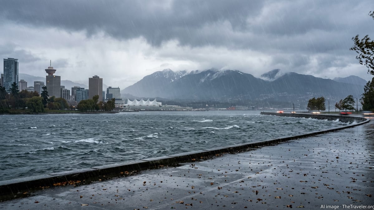
Vancouver and much of British Columbia’s South Coast are on alert as forecasts point to a powerful atmospheric river targeting the region in the coming days, raising the risk of torrential rain, urban flooding, and landslides at a time when hillslopes are already saturated from an exceptionally stormy late winter.
Get the latest news straight to your inbox!
Historic-Strength Storm Aims at the South Coast
Forecast guidance for mid March indicates that a strong Pacific moisture plume is lining up squarely with Vancouver, the Fraser Valley, and Vancouver Island, a pattern commonly known as an atmospheric river. Publicly available model data and regional discussions describe a long, narrow corridor of subtropical moisture feeding into the coast, with high confidence in a prolonged period of heavy rainfall rather than scattered showers.
Environment-focused coverage in recent seasons has already highlighted the vulnerability of British Columbia’s South Coast to these events, after several damaging atmospheric rivers in recent years brought road washouts and community-scale flooding across the Lower Mainland and Vancouver Island. Early commentary around this incoming system is emphasizing its intensity and duration, with comparisons being drawn to some of the more impactful storms of the past decade, even as final rainfall totals will depend on the exact track of the plume.
Travelers heading into Metro Vancouver over the next week are being advised through public bulletins and local media to anticipate disruptive weather conditions. Reports indicate that rain will ramp up rapidly once the core of the plume arrives, turning from steady showers to sustained downpours over a relatively short period, particularly along windward slopes of the North Shore Mountains and the Sea-to-Sky corridor.
Rainfall Totals Could Drive Urban Flooding and River Surges
Hydrological outlooks for the South Coast point to the likelihood of widespread heavy precipitation, with the most recent atmospheric river assessments for British Columbia showing that similar setups have produced 100 to 200 millimetres of rain in the Coast Mountains and on west-facing slopes of Vancouver Island within 24 to 36 hours. In past events, some exposed areas on the outer coast have recorded even higher totals, while urban cores such as central Vancouver still register intense, flooding-prone bursts.
River forecast documentation from the province consistently notes that when such rainfall converges on already wet catchments, streams and rivers respond quickly, especially in smaller basins that drain steep terrain. Even when large-scale, basin-wide flooding is not guaranteed, localized flooding along creeks, storm drains, and low-lying underpasses can emerge rapidly during the heaviest pulses of rain.
For visitors, the most immediate impacts are likely to be seen on streets and transit routes. Pooling water on key arterials, slower traffic across bridges, and temporary detours around waterlogged sections are all possible outcomes cited in earlier atmospheric river case studies for the region. Travelers relying on buses and SkyTrain to move between downtown Vancouver, the airport, and major attractions should expect delays if rainfall rates peak during commuting hours.
Beyond the city, those driving between Vancouver and nearby destinations such as Squamish, Whistler, or the Fraser Valley may encounter rapidly changing conditions. Previous atmospheric rivers have led to partial road closures, abrupt lane reductions, and reduced visibility along these corridors, underscoring the need to build extra time into itineraries during this upcoming event.
Landslide and Slope Failures a Growing Concern
The rugged topography that makes the Vancouver area so scenic also heightens its sensitivity to landslides during intense rain. Transport and infrastructure advisories issued in recent years for similar storms have repeatedly singled out highway corridors such as the Sea-to-Sky, the Malahat on Vancouver Island, and secondary mountain routes as especially vulnerable when rain persists for many hours.
Recent provincial hydrology and snowpack bulletins show a patchwork of conditions across British Columbia, with lower snowpack in some South Coast locations and deeper snow at higher elevations. When a warm, moisture-laden atmospheric river sweeps across this terrain, it can rapidly load slopes with both rainfall and snowmelt. That combination increases the risk of debris flows, slope failures, and rockfall, particularly in areas with recent wildfire scars or ongoing construction cuts.
For travelers, this risk translates into potential road closures with little warning, especially in narrow valleys and along steep coastal headlands. Past travel disruptions have included multi-hour delays while crews clear debris from highways and, in some extreme cases, temporary isolation of communities when the only access route is blocked. Those planning road trips around the storm window are being encouraged by travel advisories and tourism outlets to monitor drive-time information closely and consider alternate dates if their plans are flexible.
Popular hiking areas near Vancouver, including trails on the North Shore Mountains and around Squamish, may also become hazardous. Trail organizations and outdoor reports routinely recommend avoiding steep, forested slopes, creek crossings, and canyon routes during and immediately after powerful rain events, due to unstable ground and the heightened chance of falling branches or trees.
What Residents and Visitors Can Do to Prepare
Emergency preparedness resources across British Columbia consistently emphasize that atmospheric rivers are now a recurring part of the seasonal climate story for the South Coast. Public guidance for similar storms in recent years has focused on straightforward actions: clearing leaves and debris from gutters and storm drains around homes, securing outdoor furniture and construction materials, and checking that sump pumps and backflow systems are functioning properly in flood-prone properties.
Travelers staying in hotels, vacation rentals, or short-term accommodations in Vancouver can take simple steps to reduce disruption. These include reviewing building evacuation maps, confirming where to park vehicles away from underground or low-lying lots that could flood, and keeping electronic devices fully charged in case of power interruptions. Travel advisories often recommend maintaining a small kit with bottled water, snacks, a flashlight, a portable battery, and basic medications, particularly for those planning to drive outside the urban core.
Transportation agencies in the region typically respond to major rain events by pre-positioning crews, inspecting culverts, and preparing signage for potential closures. While these efforts are not designed specifically for tourists, they help keep key links to airports, ferry terminals, and border crossings functioning as smoothly as conditions allow. Visitors can benefit by checking airport departure boards, ferry service updates, and public transit alerts before setting out, rather than relying on normal schedules.
Local businesses, including tour operators and attractions, increasingly factor severe weather into their planning. Many now outline rain and storm policies on their booking materials, detailing how rebookings or refunds work when conditions become unsafe. Travelers with reservations around the expected peak of the atmospheric river should review these policies in advance and be prepared for last-minute adjustments to activities such as whale watching, coastal sightseeing cruises, or mountain excursions.
Travel Outlook: Disruption Likely, But the City Remains Open
Despite the intensity of the approaching storm, Vancouver is accustomed to operating through periods of extreme rain. The city’s reputation for wet weather means that much of its tourism infrastructure, from covered walkways and transit connections to indoor attractions, is built to function even when the rain feels relentless. Museums, galleries, restaurants, and shopping districts are expected to remain open, though patron numbers may fluctuate with the weather.
However, the combination of potential street flooding, transit delays, and occasional power outages means that visitors will need to stay flexible. Publicly available forecasts point to a window of greatest impact centered on the strongest surge of the atmospheric river, after which rainfall should ease back to more typical coastal showers. Travelers arriving just before or after this window may experience comparatively minor disruption, while those in the city during the peak could see more noticeable effects on timing and access.
For many, the atmospheric river will serve as a vivid reminder of the changing character of Pacific weather. Climate assessments and recent seasonal summaries for western North America describe a trend toward more intense bursts of precipitation, alternating with dry spells, a pattern that magnifies both flood and drought risks. For a coastal destination like Vancouver, adapting to these swings is becoming an essential part of safeguarding both residents and the millions of visitors who pass through each year.
As the storm approaches, the message from preparedness campaigns and travel advisories is consistent: remain aware, stay informed, and plan ahead. With realistic expectations, flexible schedules, and attention to local guidance, travelers can navigate the challenges of this historic atmospheric river while still experiencing one of Canada’s most iconic coastal cities.