
Many travelers planning a road trip along Iceland’s south coast quickly encounter two similar-sounding names: Vatnajökull and Jökulsárlón. Both are icy, dramatic and deeply photogenic, and both often appear together in guidebooks and itineraries. Yet they are not interchangeable. One is a vast glacier and national park covering a huge slice of Iceland, the other a single, spectacular glacial lagoon at its edge. Understanding how they differ will help you plan time, budget and expectations more realistically, especially if you are driving the famous Ring Road or focusing on the south coast.
Vatnajökull in Context: Iceland’s Giant of Ice and Fire
Vatnajökull is first and foremost an ice cap, the largest glacier in Iceland and one of the largest in Europe by volume. It covers roughly 8 percent of the entire country, a white shield of ice lying over active volcanoes, rugged mountains and buried valleys. The glacier itself is several thousand square kilometers in size and up to several hundred meters thick in places, a slow-moving world of crevasses and ancient compacted snow. When travelers say they are “going to Vatnajökull,” they are usually referring not to a single viewpoint but to a broad region where the glacier and its outlet tongues meet Iceland’s south coast and highlands.
Surrounding this ice cap is Vatnajökull National Park, established in 2008 and later recognized as a UNESCO World Heritage Site for its outstanding volcanic and glacial landscapes. The park stretches over a vast area of southeast, east and north Iceland, including former parks such as Skaftafell and Jökulsárgljúfur. Within its boundaries you find not only glaciers but also active volcanic systems, wide sandur plains formed by repeated glacial floods, and deep canyons carved by torrential meltwater rivers. It is a living laboratory where the interaction of ice, fire and water constantly reshapes the terrain.
For visitors, this scale has practical consequences. You do not “see” Vatnajökull in an afternoon in the same way you might see a single waterfall. Instead, you experience portions of it: a guided hike on an outlet glacier, a viewpoint where a tongue of ice spills between black volcanic ridges, or a valley where rivers of meltwater braid across dark sand. Jökulsárlón, by contrast, is a single, highly focused sight within this broader glacial world, even if it has become the most photographed symbol of Vatnajökull’s retreating ice.
What Jökulsárlón Actually Is: A Glacier Lagoon at the Ice Edge
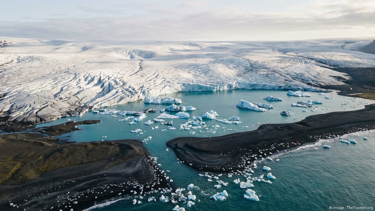
Jökulsárlón is a glacial lagoon, a deep lake filled with icebergs that have calved from Breiðamerkurjökull, one of Vatnajökull’s many outlet glaciers. As the glacier has retreated over the past century, meltwater has pooled at its snout, forming a lagoon that has grown steadily larger and deeper. Today it stretches several kilometers inland from the coast, with icebergs drifting slowly from the glacier front toward a narrow channel that meets the Atlantic Ocean. Where Vatnajökull is broad and abstract, Jökulsárlón is intimate and immediately legible: you stand at the shore and see blocks of ice drifting past, seals surfacing in the green-blue water and the fractured face of the glacier in the distance.
Geographically, Jökulsárlón lies along Iceland’s south coast right beside the Ring Road, several hours’ drive east of Reykjavík. The lagoon sits effectively at sea level, separated from the Atlantic by only a short strip of black volcanic sand and a small bridge. On the seaward side of this bridge is the beach often called Diamond Beach, where fragments of ice wash ashore, sparkling against the dark sand. Although Jökulsárlón forms part of Vatnajökull National Park, it is just one small part of that protected area and represents one specific way in which the big ice cap meets and interacts with the ocean.
The mood at Jökulsárlón also differs from most encounters with Vatnajökull proper. On the glacier you feel the solid crunch of crampons on ice and the raw exposure to weather. At the lagoon you are mostly on shore or in boats, observing rather than traversing the ice. The creaks and splashes of bobbing bergs, the calls of seabirds and the occasional crash of a calving event become the soundtrack, giving Jökulsárlón an atmosphere that is at once tranquil and slightly otherworldly.
Scale and Geography: National Park vs Single Iconic Site
One of the clearest differences between Vatnajökull and Jökulsárlón is their scale. Vatnajökull National Park spans a significant fraction of Iceland’s land area and includes highland plateaus, glaciated peaks, active volcanic systems and extended stretches of coastline. Distances between key sites inside the park can be measured in hours of driving. In practical terms, you might explore Skaftafell’s hiking trails in one part of the park one day, then need several hours on the road to reach Jökulsárgljúfur canyon or Dettifoss waterfall in another section.
Jökulsárlón, in contrast, is concentrated around a compact lagoon and its nearby beach. Most visitors park beside the Ring Road, walk a few dozen meters to the shoreline and immediately find themselves at the heart of the scenery. It is entirely realistic to spend as little as 30 to 60 minutes admiring the view on a busy road trip day, although many travelers linger far longer or book a boat tour to explore the lagoon more closely. Because access is so simple, Jökulsárlón has become a classic stop on both self-drive itineraries and organized day tours from Reykjavík and other towns.
This difference in scale shapes how you plan time. Seeing “Vatnajökull” in any meaningful sense means dedicating at least a full day, and more often several days, to the region. You might base yourself in towns such as Höfn or villages near Skaftafell and explore multiple glaciers, canyons and viewpoints. Jökulsárlón is typically one highlight within that broader program, a must-see stop but rarely the only reason to come all this way along the south coast.
Types of Experiences: On the Ice vs Beside the Ice
Experiences at Vatnajökull focus on direct contact with glacial and volcanic landscapes. In areas like Skaftafell and other glacier outlets, licensed guides lead travelers onto the ice itself. Short, introductory walks bring you onto relatively gentle sections of glacier, where you can peer into blue crevasses and feel the textured surface underfoot. More demanding excursions venture higher up, sometimes combining glacier travel with ice climbing or long day hikes. Elsewhere in the park, trails lead to viewpoints over glacial tongues, volcanic craters, geothermal areas and powerful waterfalls, giving a more varied impression of Iceland’s interior.
Jökulsárlón offers a different mode of engagement: you stay mostly on or near the water, watching icebergs that have already broken free from the glacier. In the main season, companies operate boat tours using amphibious craft and smaller rigid inflatable boats, allowing visitors to cruise among the floating bergs and, conditions permitting, approach closer to the glacier’s calving front. Even without a boat tour, simply standing on the shore and watching ice blocks drift toward the ocean can be mesmerizing. Many visitors also walk along Diamond Beach, where sculpted shards of ice rest on the black sands, creating constantly changing shapes and photo opportunities.
The physical demands differ accordingly. Glacier hiking on Vatnajökull requires proper equipment supplied by guiding companies, a basic level of fitness and a tolerance for potentially harsh weather. In return you gain a visceral sense of the glacier as a moving, creaking mass of ice and snow. At Jökulsárlón, by contrast, the primary experiences are accessible to almost everyone, including families with children and those with limited mobility. Short, mostly level walks from the parking areas lead to multiple viewpoints, and boat tours typically require only the ability to board and disembark safely.
Access, Seasonality and Practical Logistics
Because Vatnajökull covers such a wide area, access points and conditions vary considerably. Along the south coast, the main gateways are well developed, with parking areas, visitor facilities and guiding companies based near key glacier outlets. Skaftafell is one of the best-known hubs, with marked trails and visitor information, and similar services operate near other glacier tongues. In the highland interior, access is far more limited and often seasonal, depending on rough tracks and weather-dependent roads. Many of these remote areas are only reachable in summer and often require four-wheel drive or guided superjeep tours.
Jökulsárlón is unusually straightforward by comparison. The lagoon and Diamond Beach lie immediately beside the Ring Road on a largely flat, low-lying section of the south coast. Buses and rental cars pull directly into spacious parking areas, and the views are available year-round, weather and road conditions permitting. In summer, long daylight hours make it possible to visit early or late in the day to avoid the busiest times. In winter, the lagoon and beach are still accessible on many days, offering dramatic contrasts between snow, black sand and blue ice, although storms and icy roads can always interrupt travel plans.
Seasonality influences what you can do in each place. Glacier hikes on Vatnajökull operate in all seasons but may change routes or difficulty depending on conditions, with some higher or more technical excursions limited to the more stable weather of late spring and summer. Ice cave tours, another signature activity in the region, tend to be concentrated in winter when colder temperatures stabilize the ice structures. At Jökulsárlón, boat tours typically run from late spring into autumn, with exact dates varying year by year, while shore-based viewing remains possible at other times. As always in Iceland, flexibility matters: strong winds, heavy rain or poor visibility can lead to last-minute cancellations or changes.
Photographic Atmosphere and Landscape Character
From a visual standpoint, Vatnajökull presents endlessly varied compositions depending on where you are in the park. In some areas you look up at smooth, white domes and serrated ridges of ice framed by black volcanic slopes. In others you wander through mossy lava, with a glacier tongue spilling into the distance like a frozen river. Weather plays a transformative role. On clear days, the ice can glow almost white against deep blue skies, while under low cloud the scene becomes muted, emphasizing textures and subtle blues. Opportunities for wide, sweeping landscapes are plentiful, especially from higher viewpoints reached by hiking.
Jökulsárlón, by contrast, is all about close-up interplay of ice, water and light. Icebergs range from pristine blue to streaked with black ash bands, their shapes reflected in the often calm surface of the lagoon. On overcast days the colors can look soft and silvery, while in bright sun the contrast between ice, water and sky becomes sharper. Photographers spend hours here experimenting with long exposures of drifting ice, tight studies of texture and color, or wider frames that include the glacier tongue in the background. Across the road, Diamond Beach offers still more possibilities, from tiny ice crystals sparkling in the sand to larger, sculptural chunks glowing in the surf at sunrise or sunset.
These differences in character can influence how much time serious photographers choose to dedicate to each place. Vatnajökull rewards patience, multiple hikes and a willingness to explore lesser-known viewpoints beyond the obvious roadside stops. Jökulsárlón is immediately photogenic even in poor conditions, but it also rewards repeat visits at different times of day and tide. For many travelers, the ideal plan is to allow short, repeated stops at the lagoon and beach, interspersed with half or full days on glacier walks or hikes elsewhere in the national park.
Environmental Change and How It Shapes Your Visit
Both Vatnajökull and Jökulsárlón are powerful, visible examples of a warming climate in Iceland. The ice cap has been retreating for decades, with many of its outlet glaciers shrinking noticeably within a single human generation. Moraine lines, bare rock and new proglacial lakes mark where ice once lay, and guides on the glacier can often point out how far the snout has pulled back in recent years. For visitors, this means that maps, guidebooks and older photos may no longer fully match the current state of specific glacier tongues.
Jökulsárlón, in turn, exists and continues to grow precisely because of that retreat. As the Breiðamerkurjökull outlet glacier has pulled back, the lagoon has expanded and deepened. Icebergs calving from the glacier now travel a longer distance to reach the ocean, and the area of open water has increased noticeably over the past few decades. While the lagoon’s beauty is undeniable, it also carries a hint of melancholy for many observers, a reminder that they are effectively watching a glacier in decay, its fragments drifting slowly out to sea.
Travelers should be prepared for subtle but important differences between what they may have seen in iconic images and what they encounter on the ground. A viewpoint that once lay at the glacier’s edge may now be separated from the ice by bare ground or a new lagoon. Trails can be rerouted, and safety zones near calving fronts or unstable slopes may change season by season. Relying on up-to-date local advice, heeding park signage and booking with reputable guiding companies are the safest ways to experience these dynamic environments responsibly.
The Takeaway
Vatnajökull and Jökulsárlón are closely linked yet fundamentally different. Vatnajökull is the vast ice cap and national park, a shifting world of glaciers, volcanoes and highland plateaus that demands time and a sense of exploration. Jökulsárlón is one small but spectacular feature on its edge, a deep lagoon filled with icebergs calved from an outlet glacier and conveniently located beside Iceland’s main coastal road. Confusing the two is understandable, but keeping their distinct roles in mind will make trip planning far clearer.
If your primary goal is to stand among icebergs, watch them drift toward the ocean and photograph ice on black sand, then Jökulsárlón and its neighboring Diamond Beach will satisfy that wish with relatively little effort. If you want to feel a glacier underfoot, gaze across sweeping icefields, hike to waterfalls and canyons carved by meltwater and grasp the full drama of Iceland’s interior, then you are really seeking the broader experience of Vatnajökull National Park. In practice, many south coast itineraries can and should include both.
Ultimately, thinking of Vatnajökull as the source and Jökulsárlón as one of its most visible expressions can help tie the story together. The lagoon’s glowing icebergs are fragments of a much larger, evolving system. Spending time both on the glacier and at the lagoon offers a richer, more nuanced understanding of how Iceland’s ice, fire and ocean interact, and why this corner of the country has become one of the most compelling landscapes in Europe for curious travelers.
FAQ
Q1. Is Vatnajökull the same place as Jökulsárlón?
Vatnajökull is a vast ice cap and national park covering a large area of Iceland, while Jökulsárlón is a single glacial lagoon located at the edge of one of Vatnajökull’s outlet glaciers.
Q2. Can I visit Jökulsárlón without visiting the rest of Vatnajökull National Park?
Yes. Jökulsárlón lies directly beside the Ring Road, so you can stop at the lagoon and Diamond Beach without exploring other areas of the national park, although many travelers choose to do both.
Q3. Do I need a guided tour to see Vatnajökull or Jökulsárlón?
You can view Jökulsárlón and Diamond Beach independently from the shore. For glacier hikes, ice caves or travel onto Vatnajökull itself, a licensed guided tour is strongly recommended for safety and access.
Q4. Which is better for a quick photo stop, Vatnajökull or Jökulsárlón?
For a short stop, Jökulsárlón is more practical because dramatic views of icebergs and the lagoon are available within a few minutes’ walk from the parking area.
Q5. When is the best time of year to visit Jökulsárlón?
Jökulsárlón is scenic year-round. Summer offers easier driving and boat tours on the lagoon, while winter brings snow, low light and strong contrasts between blue ice and black sand.
Q6. Can I walk on Vatnajökull glacier myself?
Walking on Vatnajökull without a guide is not advised. Crevasses, unstable snow bridges and rapidly changing conditions make guided tours with proper equipment the safest option.
Q7. How much time should I plan for Jökulsárlón compared with other Vatnajökull sights?
Many travelers spend one to two hours at Jökulsárlón and Diamond Beach, and a half or full day on glacier hikes or hikes in areas such as Skaftafell within the wider Vatnajökull region.
Q8. Is Jökulsárlón suitable for families with children?
Yes. Shore viewing is easy and mostly level, and boat tours are generally family friendly, provided children are dressed warmly and follow safety instructions around water and ice.
Q9. Will I see wildlife at Vatnajökull or Jökulsárlón?
At Jökulsárlón, it is common to see seabirds and occasionally seals in the lagoon. In the wider Vatnajökull region, you may encounter birdlife and, in some areas, reindeer, but sightings are not guaranteed.
Q10. If I have only one day on Iceland’s south coast, should I prioritize Vatnajökull or Jökulsárlón?
With limited time, many visitors prioritize a stop at Jökulsárlón and Diamond Beach, then add a short glacier walk or viewpoint stop nearby if the schedule allows, giving a taste of both the lagoon and the larger Vatnajökull environment.