
Amsterdam is a city that rewards those who understand its layout. Seen from above, it is a web of concentric canals, radiating streets and distinct neighborhoods, each with a strong personality. Learning how these pieces fit together turns an overwhelming first impression into the pleasure of confident wandering.
This guide walks you through the city’s map in narrative form: the canal belt and old town at the core, the surrounding quarters that travelers most often visit, the major attractions anchored to them, and the practical details that help you move between it all.
Reading Amsterdam’s Map: How the City Fits Together
Seeing attractions on a map makes the things to do in Amsterdam easier to plan. Amsterdam’s historic center is compact, roughly a horseshoe of 17th century canals wrapped around a medieval core near Centraal Station.
The three primary canals Herengracht, Keizersgracht and Prinsengracht form a graceful set of rings known locally as the Grachtengordel, a UNESCO World Heritage site that still preserves its original plan and canal-side houses in remarkable detail. Outside this ring, the city fans out into residential districts and former working-class neighborhoods that have evolved into lively cultural quarters.
For visitors, it helps visualize differences when comparing Amsterdam vs Paris. At the very center sits the old medieval tangle around Dam Square, the Red Light District and the historic harborfront. Encircling that is the 17th century canal belt, lined with mansion houses, small museums and atmospheric bridges. Beyond the canals are the classic first ring of neighborhoods most travelers explore Jordaan to the west, De Pijp and the Museum Quarter to the south, Oost (East) and the Plantage area to the east, and the redeveloped Eastern Docklands. Across the water to the north lies Amsterdam Noord, connected by ferries and now a destination in its own right.
Because the historic center is small, distance on the map often looks greater than it feels on foot or by bike. Walking from Centraal Station through the canal belt to Museumplein, where the Rijksmuseum and Van Gogh Museum stand, takes around 25 to 30 minutes at a relaxed pace. Understanding those time scales makes it easier to cluster sights by neighborhood and avoid backtracking through the same busy streets repeatedly.
Most visitors will spend the bulk of their time in the central canal belt, Jordaan, the Museum Quarter, De Pijp and perhaps an afternoon in Noord or Oost. The more you read the map in terms of these named districts, rather than as an abstract grid of streets, the easier it becomes to choose where to stay, where to wander and where to seek out specific experiences, whether that is brown cafes, hip coffee bars, world-class museums or green parks.
The Historic Core and Canal Belt
The medieval heart of Amsterdam stretches roughly from Centraal Station down to Rokin and from the Singel canal across to the Oudezijds canals. This area contains Dam Square, the Royal Palace, the New Church and the oldest parts of the Red Light District. On the map it appears dense and irregular, reflecting centuries of piecemeal building before the grand canal plan of the 1600s.
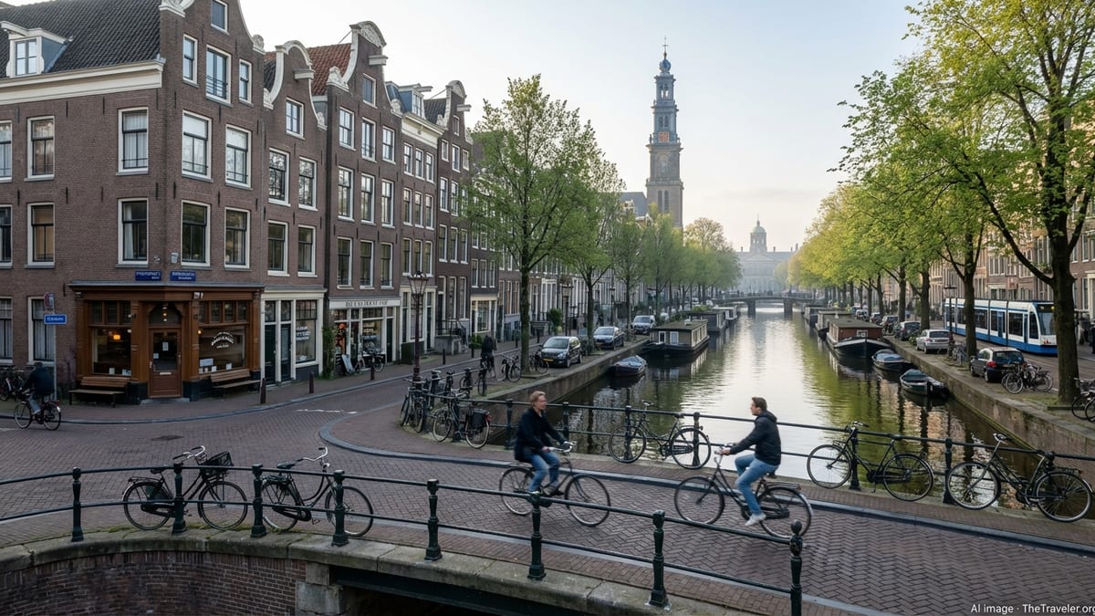
Immediately around this old core, the 17th century canal belt forms a visible arc, created by engineering the marshland into concentric canals linked by radial streets. Those main canals Herengracht, Keizersgracht and Prinsengracht are key reference lines on any city map. Walking or cycling along them is one of the most atmospheric ways to cross the center, and canal cruises trace their lines to show why the ring is considered a masterpiece of urban planning and hydraulic engineering.
The canal belt is more than a pretty backdrop. It is an address for many of Amsterdam’s intimate museums and historic interiors, such as canal-house museums, smaller art collections and private homes opened to the public. The Anne Frank House sits on Prinsengracht at the western edge of the ring, drawing visitors into narrow streets that blur into Jordaan. To the south and east, canal houses along Herengracht and Keizersgracht reveal the wealth that maritime trade brought to the city in the Dutch Golden Age.
On a practical level, the canal belt is your compass. If you are lost, finding any of the three main canals and noting the curve of the water quickly tells you whether you are moving toward the old center or away from it. Bridges are frequent and often lined up with cross streets, so they are reliable crossing points when plotting routes. Many tram lines also follow or cut across the ring, tying together the medieval core, Leidseplein, Rembrandtplein and the Museum Quarter.
Jordaan: West of the Canals
West of Prinsengracht, the streets tighten into the Jordaan, a neighborhood that once housed craftsmen and laborers and is now one of Amsterdam’s most desirable addresses. On most printed or digital maps, Jordaan is clearly labeled as a rectangular wedge between the canal belt and the broad avenues of Marnixstraat and Westerstraat. The district’s internal grid of short streets and canals such as Egelantiersgracht makes it easy to recognize once you cross over from the main canal ring.
From a traveler’s perspective, Jordaan is where the city’s postcard charm meets a more local rhythm. It is here that you find corner brown cafes, independent shops, weekly markets and the sort of leafy courtyards that hint at the neighborhood’s working-class past. Westerkerk, whose tower overlooks the Anne Frank House, marks Jordaan’s eastern edge. Walking westward from there, the crowds thin and the scale of the city shrinks to something more village-like.
Important attractions in and around Jordaan include the Anne Frank House and Westerkerk along with photogenic canal views on Brouwersgracht, often cited as one of Amsterdam’s loveliest streets. The Noordermarkt square hosts organic and flea markets on different days of the week, drawing both locals and visitors. While Jordaan lacks blockbuster museums, its appeal lies in wandering. When reading a map, it is the neighborhood you choose when you need a slower, more residential counterweight to the central canal belt.
Logistically, Jordaan sits within walking distance of Centraal Station and the city center, but tram lines also skirt its edges, especially along Marnixstraat. Many first-time visitors choose accommodation here precisely because it puts them between the busy heart of the canal belt and the relative calm of a lived-in quarter. Once you understand where Jordaan lies in relation to Prinsengracht, it becomes a natural extension of any canal-side itinerary.
Museum Quarter and De Pijp: South of the Ring
South of the canal belt, Amsterdam opens into a zone that feels more spacious on the map and on the ground. The Museum Quarter is built around Museumplein, a large green square framed by the Rijksmuseum, Van Gogh Museum, Stedelijk Museum and the Concertgebouw. On most maps, Museumplein appears as a conspicuous rectangle of green at the southern end of the city center, directly accessible from the canals by way of the Rijksmuseum’s famed underpass.
The Museum Quarter is an anchor for many itineraries. From here, it is a short walk or tram ride to Leidseplein, Vondelpark and the upscale shopping streets of Oud-Zuid. Visitors who stay in this area benefit from quick access to the city’s major museums combined with quieter residential streets just beyond the main cultural institutions. It also connects conveniently to the airport buses, which terminate at Museumplein or nearby stops, reducing the need to change trams with luggage in the busier central areas.
Directly east of the Museum Quarter lies De Pijp, once a dense blue-collar neighborhood and now one of Amsterdam’s liveliest melting pots. On the map, De Pijp is separated from the inner center by the Ruysdaelkade and Stadhouderskade ring road, and it stretches south toward the Amstel river. The neighborhood is famous for the Albert Cuyp Market, which occupies a long axis through its heart, and for Sarphatipark, a pocket of greenery ringed with townhouses and cafes.
The new north-south metro line has placed De Pijp firmly on the main transport grid, with a station that drops you in the center of the neighborhood within minutes of Centraal Station. This change is important when reading the modern map of Amsterdam: what once felt slightly out of the way is now one of the most accessible quarters in the city. Travelers can easily spend a day moving between the museums of Museumplein, the market and eateries of De Pijp and the cafés that line the Amstel, all within a compact southern wedge of town.
Oost, Plantage and the Green East
To the east of the city center, the map opens into larger blocks, wide avenues and green spaces that give Oost a different character from the canal belt. The Plantage district, just beyond Waterlooplein, provides a soft transition: on the map it sits as a leafy pocket between the old town and the more modern East, home to Artis Zoo, the Hortus Botanicus and the Jewish Cultural Quarter. This area offers museums in a quieter setting than the crowded center.
Continuing east, Amsterdam Oost broadens into a series of neighborhoods that have evolved quickly in the past two decades. Oost is clearly delineated on most maps by the large Oosterpark and by the wide thoroughfare of Linnaeusstraat. Once overlooked by visitors, it now appears increasingly often in city guides thanks to its mix of multicultural food streets, waterfront redevelopment and creative venues. For travelers seeking a less tourist-saturated base, Oost can be appealing while still remaining only a few tram stops from the center.
Major attractions in the eastern stretch include Tropenmuseum by Oosterpark, with its focus on world cultures, and the revitalized Eastern Docklands, where modern architecture looks out over the IJ. These docklands, built on peninsulas stretching into the water, appear as striking finger-like forms on the map. They host residential developments, arts venues and waterfront promenades that are pleasant for an afternoon walk or bike ride away from the bustle of the inner city.
Public transport makes the East straightforward to navigate. Several tram lines run from Centraal Station through Plantage and Oost toward outlying districts, effectively stitching the old center to these newer residential areas. Understanding where your tram line runs on the map is often the simplest way to orient yourself in Oost, since many stops align with major parks or squares that serve as obvious landmarks when you emerge to street level.
Across the Water: Amsterdam Noord and the IJ Waterfront
North of Centraal Station, separated by the broad IJ waterway, Amsterdam Noord stretches along the opposite shore. On city maps, this expanse of docks, residential areas and green space can look detached from the historic core. In practice, free ferries from behind the station make the crossing in a few minutes, and Noord has become a standard entry in guidebooks for its creative hubs, panoramic views and contemporary architecture.
The most obvious reference point in Noord is the cluster around the northern ferry landing. Here you find the A’DAM Tower, whose observation deck looks across the historic skyline, and the Eye Filmmuseum in a striking white building on the waterfront. These icons, visible from much of the southern shore, make it easy to locate Noord on the map and in real life. From this nucleus, bike paths extend along the waterfront and into the green hinterland of dikes, villages and allotment gardens.
Historically a shipbuilding and industrial zone, Noord now mixes new residential developments with cultural venues and street art. NDSM Wharf, further west along the northern bank, appears on the map as a large rectangular dock area reached by a separate ferry. This former shipyard has been repurposed into a creative quarter with studios, event spaces and seasonal festivals. It draws visitors who are comfortable venturing beyond the postcard center for a more experimental side of the city.
Despite lying across the water, Noord is practical to incorporate into a short stay. The ferries run frequently and are part of the city’s public transport network, so no additional ticket is needed if you are using most standard travel cards. Once you mentally reposition the IJ from being a boundary to being a central boulevard of water, the map of Amsterdam expands, and what once seemed peripheral becomes just another accessible neighborhood option.
Major Attractions by Map and How to Connect Them
Understanding how Amsterdam’s major sights sit in relation to one another turns a list of names into a coherent route. Centraal Station anchors the northern end of the historic core. From there, Dam Square lies to the south, roughly a 10-minute walk past shops and the narrow Damrak canal. The Royal Palace and Nieuwe Kerk front Dam Square, with the Red Light District spreading eastward and the shopping streets of the Nine Streets and Kalverstraat stretching west and south.
To the west of Dam Square and the old core, the Anne Frank House sits on the Prinsengracht canal, near Westerkerk. If you mark this on a map and then trace Prinsengracht south, you pass through the canal belt toward the Jordaan on one side and the historic Grachtengordel mansions on the other. Continuing west from the Anne Frank House, the rectangular grid of Jordaan unfolds, while heading east takes you back toward the denser medieval streets.
South from the canal belt, Museumplein forms the cultural heart, with the Rijksmuseum on its northern edge, the Van Gogh Museum adjacent, and the Stedelijk Museum along the western side. Vondelpark lies just to the west, creating a corridor of green that stretches toward residential Oud-West. From Leidseplein, a lively entertainment square northwest of Museumplein, trams and streets radiate back into the city center, up toward the Jordaan and east toward Rembrandtplein and the Amstel river.
Other key attractions such as the Heineken Experience, the Hermitage Amsterdam, Artis Zoo and the Jewish Cultural Quarter are distributed along the southern and eastern flanks of the inner city. On a map, they trace a loose loop that follows the Amstel and the eastern canals, making it possible to move between them mostly on foot. Seeing these sites as clusters Museumplein and De Pijp in the south, canal belt and Anne Frank House to the west, Amstel and Plantage to the east helps you plan each day around one or two zones rather than zigzagging across town.
Getting Around: Trams, Metro and Walking Routes
Amsterdam’s public transport network overlays the historic street pattern with a modern set of tram and metro lines. For visitors, the trams remain the most intuitive way to hop between neighborhoods. Routes run in rough north-south and east-west axes, linking Centraal Station with Museumplein, De Pijp, the Jordaan, Oost and Zuid. Stops are frequent and generally located at major squares or along the main thoroughfares that appear in bold on printed maps.
The metro system is more limited in the central area but crucial for certain connections. The north-south line runs from Noord, under the IJ, through Centraal Station and down through Rokin, Vijzelgracht and De Pijp to Zuid station. This line compresses what would be long tram journeys into mere minutes and makes it even easier to treat De Pijp and Zuid as natural extensions of the city center. East-west metro lines serve areas beyond the typical tourist radius but are handy if you stay farther out.
Ticketing is straightforward. The municipal transport company sells hour and day tickets that allow unlimited use of trams, buses and metro within the city for a set period, with current day ticket prices for adults starting below the cost of a couple of single rides. There are also combined travel tickets that include airport transfers and regional travel, alongside multi-day passes that can be cost effective for stays of several days. These products are widely available at ticket machines, service points and via the transport app.
Despite this network, much of Amsterdam remains easiest to navigate on foot or by bicycle. The center is compact, crossings along the canals are frequent and the terrain is flat. Walking between adjacent neighborhoods often takes less time than waiting for a tram, especially within the canal belt. When reading a map, consider distances in terms of walking minutes rather than kilometers: if two sights are only a couple of canal blocks apart, it is almost always worth making the journey on foot to experience the streets that connect them.
The Takeaway
Amsterdam’s map is unusual, but once you understand its logic it becomes remarkably easy to read. The medieval core and 17th century canal belt define the historic center; Jordaan, the Museum Quarter, De Pijp, Oost and Noord form a first ring of neighborhoods that most visitors will explore; and major attractions cluster in a handful of obvious zones. Thinking in terms of these districts, rather than individual street names, helps you plan days that flow naturally from place to place.
Canals serve as both scenery and orientation tools, guiding you along gentle curves that lead either toward the old town or outward to quieter quarters. Trams and the north-south metro thread through this pattern, shortening journeys when needed, while walking and cycling remain the most satisfying ways to appreciate how the city’s layers connect. By combining a sense of the neighborhoods with an understanding of where key attractions sit among the canals, you can navigate Amsterdam with the same ease that locals do, turning every wander into a confident exploration rather than a test of your sense of direction.
FAQ
Q1. How is Amsterdam’s city center laid out for a first-time visitor?
Amsterdam’s center is a compact medieval core encircled by 17th century canals that form a horseshoe around it. The three main canals Herengracht, Keizersgracht and Prinsengracht curve around the old town, and most major sights sit either inside this ring or just beyond it in neighborhoods like Jordaan and the Museum Quarter.
Q2. Which canal is best to use as a reference point when I am lost?
Prinsengracht is often the most helpful, because it runs along the western edge of the central ring and passes the Anne Frank House and Westerkerk. If you find Prinsengracht and note the curve of the canal, you can tell whether you are heading back toward the medieval core or outward toward Jordaan and the outer neighborhoods.
Q3. What neighborhood is best for staying close to the main attractions?
If you want easy access to major museums, the Museum Quarter around Museumplein is ideal. For a more local atmosphere while remaining walkable to the center, Jordaan or De Pijp are good choices. The canal belt itself is the most atmospheric but often more expensive and busy than nearby residential streets.
Q4. How long does it take to walk from Centraal Station to the Museum Quarter?
At a relaxed pace, it usually takes between 25 and 30 minutes to walk from Centraal Station through the canal belt to Museumplein. The route is straightforward and passes many landmarks, but you can shorten the journey with a tram or by using the north-south metro to travel part of the way.
Q5. Is Amsterdam Noord worth visiting if I have only a short stay?
Yes, Amsterdam Noord is easy to reach via free ferries behind Centraal Station and offers a different perspective on the city. Even a short visit to the northern waterfront, the observation tower or NDSM Wharf can provide panoramic views and a sense of the city’s former industrial side without taking too much time from a short itinerary.
Q6. How do I get from the airport to the central neighborhoods on the map?
Most travelers either take a direct train from the airport to Centraal Station or use airport buses that stop at Museumplein and Leidseplein. From those hubs, trams and the metro connect to Jordaan, De Pijp, Oost and other districts, so you can reach most central accommodations with one change at most.
Q7. Are the main attractions close enough to visit without using public transport?
Many are. The canal belt, Jordaan, Dam Square, Anne Frank House, the Red Light District and parts of the Museum Quarter are within comfortable walking distance of one another. Public transport becomes more useful if you are moving repeatedly between far corners of the city, such as Noord, Oost and the southern districts, or if mobility or weather make walking less appealing.
Q8. What is the easiest way to tell where one neighborhood ends and another begins?
Often, natural boundaries like canals, major streets and parks mark the shift between neighborhoods. For example, Prinsengracht and the narrower canals behind it signal the transition from the canal belt into Jordaan, while the ring road around the southern canals separates the inner center from De Pijp and the Museum Quarter.
Q9. Do I need to worry about fare zones when using trams and metro in the center?
For typical visitors staying within Amsterdam, you generally do not have to think about zones. Day and multi-day tickets cover trams, buses and metro throughout the urban area, and you simply check in and out with each journey. Zonal distinctions matter more for certain regional trips beyond the city limits.
Q10. Is cycling a practical way to navigate the neighborhoods and canals?
Cycling is one of the most practical and enjoyable ways to move between Amsterdam’s neighborhoods. The city is flat, distances in the center are short and there is an extensive network of bike lanes. As long as you follow local cycling etiquette and pay close attention at intersections and tram tracks, a bike can greatly expand how much of the map you can explore in a single day.