
Amsterdam is a compact, water-laced city where understanding the layout and transport system can transform a good trip into a great one. The historic center is wrapped in a crescent of canals, ringed again by 19th and 20th century neighborhoods and connected by an efficient web of trams, metro lines, buses and free ferries. For visitors, the key to enjoying Amsterdam is learning how these layers fit together, which neighborhoods suit different travel styles, and how to move between them without losing time or energy.
Understanding Amsterdam’s City Layout
Understanding the layout helps prioritize the main things to do in Amsterdam. Amsterdam’s historic core is small enough to cross on foot in about 30 minutes, yet its structure can feel confusing at first.
At the heart is the medieval old town around Dam Square and Central Station, where narrow streets fan out in irregular patterns. Encircling this center are the 17th century canals known as the Grachtengordel, a UNESCO World Heritage listed belt of concentric waterways defined by the Singel, Herengracht, Keizersgracht and Prinsengracht. Beyond these canals the streets straighten and widen into later residential districts that form a loose ring around the center.
The city is often described as a half-moon facing the IJ waterfront. Central Station sits on this northern edge, fronting the river-like IJ. South from the station you cross the old town and canal belt, then reach 19th century neighborhoods and major parks such as Vondelpark and Oosterpark. To the north of the IJ is Amsterdam-Noord, once industrial and now rapidly redeveloped, connected by frequent free ferries. This layered, semi-circular plan means that distances look greater on a map than they feel on the ground, especially once you get comfortable tracing your way along canals.
Another structural feature to understand is the role of the Singelgracht, the semi-circular canal that once marked the outer defensive boundary of the city. Today it still outlines the central area, following the line of main inner ring roads like Nassaukade, Stadhouderskade and Mauritskade. For practical purposes, most first-time visitors spend much of their time inside or just beyond this ring. Knowing whether your hotel or apartment is inside the Singelgracht, just outside it, or further out in newer districts will help you anticipate journey times and choose the right mode of transport.
Amsterdam’s compactness is balanced by its highly varied neighborhoods. The feel of the medieval center around Damrak bears little resemblance to the leafy canal houses of the western Grachtengordel or the wide boulevards of Amsterdam-Zuid. Planning your days by clustering sights within adjacent areas rather than zigzagging across town will save time and help you appreciate how the historic, canal belt and newer quarters connect. All this often leads travelers to ask whether Amsterdam is worth visiting.
The Historic Center and Canal Belt
The old center stretches roughly from Central Station to the inner canal of the Singel. This is the Amsterdam of busy shopping streets, centuries-old churches and the famed Red Light District. Streets such as Damrak, Kalverstraat and Nieuwendijk carry much of the foot traffic, lined with chain stores and cafes. Radiating from Dam Square, narrow alleys lead to more intimate pockets where traditional brown cafes, small galleries and historic courtyards give a sense of the city’s mercantile past.
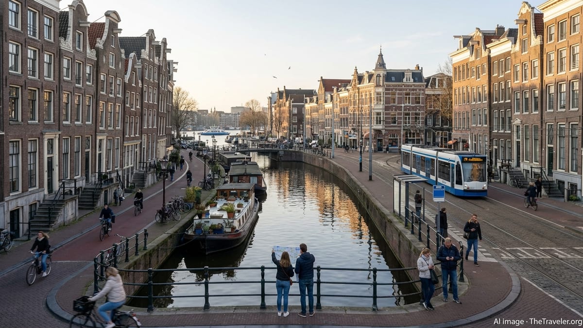
Immediately west and south of the medieval core lies the canal belt, built during the Dutch Golden Age in the 17th century. The main canals start near Brouwersgracht in the northwest and sweep in a broad arc toward the Amstel River in the southeast. Each ring has a slightly different personality: Herengracht showcases elegant patrician houses, Keizersgracht feels a touch quieter and more residential, while Prinsengracht has more cafes, houseboats and a lived-in charm. Canal houses from this period often conceal deep plots and ornate interiors behind narrow gabled facades, a reminder of the city’s long commercial history.
Within the canal belt is the micro-neighborhood known as the Nine Streets, a tight grid linking the main canals with cross streets full of boutiques, vintage shops and cafes. This area typifies central Amsterdam’s layered identity: historic architecture, independent retail, creative businesses and steady streams of visitors. In the evening, the bridges light up and reflections ripple on the water, making this one of the most atmospheric places to stroll at sunset.
For visitors, the historic center and canal belt function as both backdrop and orientation tool. Many of Amsterdam’s flagship museums, such as the Anne Frank House, sit directly on or near the canals. Boat tours trace loops through the Grachtengordel, giving new arrivals a literal overview of the city’s structure. Learning the names and order of the main canals, and how they lead toward either Central Station or the Amstel, makes it easier to navigate back to your base even if you have wandered deep into side streets.
Characterful Neighborhoods Beyond the Core
Venturing just beyond the canal belt reveals neighborhoods with distinct personalities that can shape the tone of your stay. To the west lies Jordaan, once a working-class district and now one of Amsterdam’s most desirable areas. Its narrow streets, small inner courtyards and mix of cafes, independent shops and galleries create a village-like atmosphere. Picturesque canals such as Bloemgracht and Egelantiersgracht invite slow wandering, while weekly markets and cultural venues keep the area firmly part of daily city life rather than an open-air museum.
South of the center is De Pijp, a dense 19th century district known for the Albert Cuyp Market and a lively mix of eateries, bars and small shops. Historically home to immigrants and workers, it has become one of the city’s most popular food neighborhoods, with cuisines from around the world sharing space with traditional Dutch snack bars and modern brunch spots. The Sarphatipark provides a pocket of greenery amid the tightly packed streets, and the area’s tone shifts through the day from market bustle to evening social hub.
Further west, Oud-West and the area around Kinkerstraat, De Clercqstraat and Bilderdijkstraat have evolved into a dynamic residential quarter with strong local energy. The converted tram depot complex around De Hallen now houses a popular indoor food court, cinema and creative spaces, drawing both residents and visitors. This side of town also provides easy access to Vondelpark, Amsterdam’s best-known green space, which stretches west to east just south of the canal belt and acts as a natural boundary between older and newer streets.
To the south, Amsterdam-Zuid combines broad, tree-lined avenues, upscale shopping streets and major cultural institutions. The Museumplein, home to the Rijksmuseum, Van Gogh Museum and Stedelijk Museum, anchors the area, while nearby streets showcase examples of Amsterdam School architecture and spacious early 20th century housing. Staying here offers a slightly calmer base with quick tram or bike rides to the center and straightforward connections to the business district and rail links beyond the city.
Emerging Districts: Noord, Oost and the Outer Ring
Across the IJ waterfront, Amsterdam-Noord has shifted from industrial periphery to creative frontier. Former shipyards and warehouses now contain cultural spaces, design studios, music venues and riverside bars. The area retains a more open, low-rise character than the dense center, with bike paths that thread through suburban streets and green spaces toward scenic dike villages further north. Landmark attractions such as a panoramic observation deck and cultural hubs at former docklands introduce many visitors to this side of the city.
The eastern districts, broadly referred to as Oost, reveal another facet of the city’s expansion. Around Oosterpark, late 19th century buildings house a mixture of long-term residents, students and newcomers, while the park itself provides leafy respite. Further east, the Indische Buurt and areas near the waterfront show layers of migration history alongside rapid regeneration, with an increasing number of cafes, restaurants and small cultural spaces opening along former through-streets and new squares.
To the southeast lies Amsterdam-Zuidoost, a more modern, purpose-built district centered on large-scale developments and major venues. The area around the stadium and concert halls combines office towers, shopping centers and entertainment facilities. Though more often visited for specific events than casual strolling, it is an important part of the city’s fabric and a reminder that Amsterdam extends far beyond its postcard canals.
The outer ring of neighborhoods is linked by radial routes that run from the center outward, both at street level and via tram and metro corridors. This structure allows visitors to base themselves in quieter, often more affordable districts while maintaining direct lines into the core. Understanding that most of these outer neighborhoods are aligned along spokes from Central Station or major inner squares helps in choosing accommodation and planning daily routes.
Getting Around: Trams, Metro, Buses and Ferries
Amsterdam’s public transport network is run primarily by the municipal operator GVB, which continues to operate the city’s trams, metros, most buses and ferries under a long-term concession. For visitors, the system’s main advantages are frequent services, straightforward ticketing and the ability to reach almost any neighborhood with a single change. Trams dominate street-level movement in and around the center, while the metro and suburban trains handle longer journeys and commuting corridors.
The tram network radiates from Central Station and important inner-city hubs such as Leidseplein, Museumplein and Rembrandtplein. Routes loop through the western and southern neighborhoods and along main streets that parallel parts of the canal belt. Stops are closely spaced, making trams particularly useful when you want to avoid walking in heavy rain or if you are traveling with luggage or mobility constraints. Electronic displays at stops show real-time arrival information, and onboard announcements indicate the next stop and key transfer points.
The metro currently consists of five lines that connect northeastern and southeastern suburbs to the inner city, including the cross-city North South Line. This line links Amsterdam-Noord with Central Station and continues south beneath the historic center and canal belt to reach De Pijp, the business district and beyond. Older eastbound and southeastbound lines serve areas such as Amsterdam-Zuidoost and Gaasperplas, integrating residential districts into the wider network. For many visitors, the metro is most useful for quickly moving between the northern waterfront, central stations and the southern neighborhoods, especially during peak hours.
Complementing these are extensive bus routes that fill in gaps between tram and metro corridors and run deeper into outlying districts and surrounding municipalities. Night buses keep the network functioning after trams and most metro services stop, ensuring that late-returning travelers can still move between central nightlife areas and peripheral accommodations. On the water, GVB ferries cross the IJ between Central Station and various points in Amsterdam-Noord, carrying pedestrians and cyclists free of charge and offering a short, scenic ride with views of both the historic skyline and new developments.
Tickets, City Cards and Payment Options
Amsterdam has streamlined public transport payments in recent years, giving visitors a choice between pay-as-you-go options and timed passes. Most travelers can now use contactless bank cards or mobile payment apps directly on trams, buses and metro gates by tapping in and out, with fares calculated per journey. Traditional smartcards remain in use, but short-stay visitors increasingly rely on bank cards or tourist products rather than purchasing separate local cards.
Timed public transport tickets sold by GVB, such as 24, 48 or 72 hour passes, offer unlimited travel on the operator’s trams, buses, metros and selected ferries within the validity period. These passes can be practical if you are staying slightly outside the center or expect to make multiple trips each day. Cards are typically activated upon first check-in and count down in hours rather than by calendar day, which can be convenient for late arrivals or early departures.
The I amsterdam City Card remains a popular option for visitors intending to combine museum visits with frequent public transport use. Available in several durations, it bundles unlimited travel on GVB services with entry to many museums and attractions, along with access to canal cruises and discounts at selected venues. The card now exists in both physical and digital forms; the digital version is managed via a dedicated app, which you activate only when you are ready to begin the validity period of your pass.
When deciding between simple contactless payment, a GVB timed ticket or a broader city card, consider how often you will travel each day, which neighborhoods you will visit, and how many museums or paid attractions you intend to see. Travelers who plan to walk or cycle most of the time and visit only a few museums may find pay-as-you-go or a basic day ticket sufficient. Those planning several days of sightseeing concentrated in museums and cultural sites, particularly around Museumplein and the canal belt, may benefit financially and logistically from a city card solution.
Navigating on Foot and by Bicycle
Walking is one of the most efficient and rewarding ways to explore Amsterdam. Within the central area, most major sites fall within a 20 to 30 minute walk of each other. The challenge lies less in distance and more in the city’s layered street structure and the constant flow of trams, cyclists and delivery vehicles. Pedestrian crossings are clearly marked, but visitors should pay close attention to bike lanes, which are often separated from car traffic yet run beside sidewalks. Looking both ways before stepping across any strip of red asphalt becomes second nature after a day or two.
For many, cycling is the defining Amsterdam experience. The city has an extensive network of bike lanes, traffic lights tailored to cyclists and large parking facilities near stations and squares. Numerous rental outlets offer city bikes geared to locals rather than tourist-style cruisers, and some hotels have in-house fleets. Before setting off, familiarize yourself with basic local cycling etiquette: keep to the right, signal turns clearly with your hand, obey bike traffic lights, and avoid stopping suddenly in the middle of a busy path to take photos.
The flat terrain makes cycling appealing even to those unaccustomed to riding in cities, but the busiest central streets can feel intense during peak periods. New riders may find it helpful to begin in quieter areas such as the outer stretches of Vondelpark, the smaller canals of Jordaan or the residential streets of Oost before tackling main corridors. Guided bike tours offer another way to gain confidence, pairing orientation to the city’s layout with practical coaching on local traffic dynamics.
Combining walking, cycling and public transport allows you to match the mode to the moment. For example, you might take a tram from your accommodation to Museumplein, spend several hours walking between museums and canals, then cycle along the riverfront in the evening. Amsterdam’s compactness means that switching between these options seldom takes more than a few minutes, and aligning your movements with the city’s natural patterns of commuting and leisure lends your visit a more local rhythm.
Planning Your Visit by Neighborhood
Organizing your time in Amsterdam around clusters of neighborhoods can reduce backtracking and reveal the city’s structure in a natural way. One common approach begins in the historic center and canal belt, where many new arrivals spend their first day. You might arrive via Central Station, explore Dam Square and nearby streets, then follow the canals into the Nine Streets and Jordaan, ending with an evening stroll along illuminated bridges. This sequence introduces the medieval core, Golden Age canal ring and western residential quarters in one continuous loop.
On a second day, attention can shift south to the Museumplein and De Pijp. Starting from Leidseplein or a tram stop near Vondelpark, you can walk or ride to the main art museums, then continue on foot or by tram to the market streets and cafes of De Pijp. Pausing in Sarphatipark or along smaller side streets helps reveal the transition from monumental cultural institutions to everyday residential life. If time allows, an evening detour back through the canal belt by tram or on foot ties these southern experiences back into the central narrative of the city.
Further days lend themselves to excursions into emerging or specialized districts. Amsterdam-Noord, reached in minutes by ferry, can occupy half a day with its waterfront views, cultural venues and bike routes. Oost offers a different urban texture around Oosterpark and beyond, while Amsterdam-Zuidoost may feature in plans for concerts or sports events. By allocating at least part of a day to each of these outer areas, you gain a broader sense of Amsterdam as a living, evolving city, not only a heritage-laden center.
Throughout, it helps to keep an eye on how the canals, the Singelgracht ring and major cross streets align. Many travelers find that after two or three days they can sketch the city’s layout from memory, with Central Station and the IJ to the north, the canal rings sweeping southward, and specific neighborhoods anchoring each compass point. This mental map makes even unscripted wandering feel purposeful, and it turns each tram ride, ferry crossing or bike journey into another opportunity to connect the pieces of Amsterdam’s urban puzzle.
The Takeaway
Amsterdam’s enduring appeal lies not only in its museums and canals, but in how gracefully its city layout and transport systems serve daily life. A compact medieval core, a harmonious ring of 17th century canals and a series of distinctive surrounding neighborhoods give the city clear structure without rigidity. For visitors, investing a little time in understanding this structure pays dividends, turning potential confusion at a tangle of waterways and winding streets into confidence and curiosity.
Public transport, whether by tram, metro, bus or ferry, knits the city’s districts together and remains straightforward to use with modern payment options and tourist-oriented passes. Walking and cycling fill in the finer detail, opening access to back streets, pocket parks and waterside ambles that no vehicle can fully reveal. By aligning your plans with the city’s geography, grouping activities by neighborhood and staying alert to the subtle transitions between historic and modern quarters, you can experience Amsterdam in a way that feels both efficient and deeply human.
However long you stay, think of Amsterdam as a series of connected layers: the old core, the canal belt, the surrounding residential rings and the evolving outer districts across and along the IJ. Move through those layers with eyes open, and the practical concerns of navigation and transport will soon recede into the background, leaving space for the city’s textures, stories and daily rhythms to come to the fore.
FAQ
Q1. How long does it take to get orientated in Amsterdam’s city layout?
Most visitors find that after two or three days of walking and using trams or the metro, they can navigate the central area and nearby neighborhoods with relative ease, especially once they recognize Central Station, the canal rings and major squares as fixed reference points.
Q2. Is it better to stay inside the canal belt or in an outer neighborhood?
Staying inside the canal belt places you within walking distance of many major sights but usually at higher accommodation costs, while outer neighborhoods such as De Pijp, Oud-West or parts of Oost can offer better value and a more local feel, with frequent trams and metro lines keeping journey times into the center short.
Q3. Do I need a city transport pass, or can I just tap with my bank card?
If you make only a few journeys each day, tapping in and out with a contactless bank card or mobile payment often suffices, but if you expect to ride several trams or metros daily or combine transport with museum visits, a timed GVB pass or a broader city card that includes attractions may be more economical and convenient.
Q4. Are Amsterdam’s ferries useful for tourists or mainly for commuters?
While many locals use the IJ ferries for daily commuting between the center and Amsterdam-Noord, visitors also benefit from the frequent, free crossings, which provide quick access to emerging northern districts and offer striking views of the skyline and waterfront developments along the way.
Q5. Is cycling in the city center safe for someone who is not used to urban biking?
The extensive bike lane network and cycling culture make Amsterdam comparatively friendly to riders, but the center can feel busy at peak times, so less experienced cyclists may prefer to start in calmer areas or parks, join a guided tour for an introduction, and build confidence before riding through the most crowded streets.
Q6. How late do trams and metros run at night?
Tram and metro services generally wind down around midnight, with specific times varying by line and day of the week, after which night buses cover key routes so that travelers can still return to more distant neighborhoods from central nightlife areas.
Q7. Which neighborhoods are best for experiencing Amsterdam like a local?
Areas such as Jordaan, Oud-West, De Pijp and parts of Oost combine residential streets, cafes, markets and small venues that serve everyday city life, offering a more grounded atmosphere than the busiest tourist corridors around Dam Square and the main shopping streets.
Q8. How walkable is Amsterdam for visitors with limited mobility?
Amsterdam’s compactness helps, but older streets, cobblestones, bridges and steps into historic buildings can present challenges, so planning routes that rely on flatter main streets, selecting accessible museums and using trams or metros to reduce walking distances can significantly improve comfort for travelers with mobility concerns.
Q9. Are canal cruises a good way to understand the city layout?
Cruising the canals offers a visual overview of the Grachtengordel and its relationship to the old town and modern districts, making it a useful early activity that helps you translate the abstract lines of a map into a lived sense of how the rings and radial streets connect.
Q10. How far in advance should I plan neighborhood-based itineraries?
You do not need to schedule each hour, but deciding in advance which neighborhoods to focus on each day, and noting a few key streets, parks and tram or metro stops, will reduce unnecessary backtracking and make it easier to see how the different parts of Amsterdam fit together during your stay.