
Arizona rewards unhurried travelers. Across a few hundred miles, the state shifts from saguaro studded desert to cool pine forests and the yawning chasms of the Colorado Plateau. This itinerary traces a scenic loop from Phoenix through Sedona, Flagstaff, the Grand Canyon and Monument Valley, with an optional detour toward Page and Lake Powell. It is designed for travelers who want a mix of classic viewpoints and quieter corners, with time to absorb the stark desert light, the deep silence of canyon overlooks and the changing colors of sandstone at sunrise and sunset.
How Long You Need and When To Go
A flexible but realistic timeframe for this Arizona route is seven to ten days. That window allows you to drive manageable distances, spend two nights in several key bases, and adjust plans for weather or road conditions. With less time, you can still link Phoenix, Sedona and the Grand Canyon, but you will need to be selective about stops and focus on one canyon region rather than trying to see every viewpoint.
Season matters in Arizona more than simple temperature readings suggest. Spring and autumn are generally the most comfortable times for this itinerary, when desert highs are warm but not extreme and higher elevation towns such as Flagstaff and the Grand Canyon’s rims are cool and crisp. Winter can be atmospheric in Sedona and the high country, with occasional snow that transforms red rock and canyon rims, but it can also bring icy roads and temporary trail closures. Summer delivers intense heat in the low desert, including Phoenix and stretches of highway with little shade, while lightning storms can develop quickly during the late summer monsoon period, especially around canyons and plateaus.
Road conditions can vary from smooth interstate to winding two lane scenic byways with sharp curves and steep grades. Most of this route is accessible in a standard two wheel drive rental car, but you should check current advisories from Arizona transportation authorities and the National Park Service before travel. Wildfire activity, rockfall or seasonal maintenance work sometimes trigger temporary closures or detours on scenic roads, including those that access canyon lookouts and high country passes.
Accommodation availability is another reason to plan ahead. Lodges and campgrounds inside Grand Canyon National Park often book months in advance for peak periods, and smaller desert and canyon towns may have limited rooms during popular festivals or school holiday weeks. Consider reserving at least your first and last nights, your Grand Canyon stay and any in park campground or lodge as early as possible, while leaving some flexibility in the middle of the itinerary for weather dependent choices.
Phoenix to the Red Rocks of Sedona
Phoenix is a natural starting point for this itinerary, with a major airport, a wide range of rental car options and quick access to the open desert. Before you leave the city, allow at least a half day to acclimatize. The Sonoran Desert around Phoenix is known for iconic saguaro cacti, and short walks in nearby preserves introduce you to the desert’s subtle color and texture. Morning and late afternoon are the most comfortable times for any outdoor exploration, particularly in warmer months.
From Phoenix, head north on Interstate 17 toward the Verde Valley. The drive itself offers a gradual transition from metropolitan sprawl to open desert and then to higher elevation scrub and juniper. As you gain altitude, the profile of the landscape changes, with mesas and distant red buttes emerging near the horizon. Turnoffs toward Montezuma Castle National Monument and the Verde River corridor invite short detours if you have a full day to make the trip, though many travelers prefer to continue directly to the heart of red rock country.
Approaching the Village of Oak Creek, the highway links with State Route 179, a short but celebrated section of road designated as the Red Rock Scenic Byway. This corridor is recognized nationally for its concentration of sandstone formations, and it functions as more than a simple connector. Even if you are eager to reach Sedona, it is worth allowing extra time for pullouts and brief stops to photograph the changing perspectives on bell shaped buttes, sculpted spires and broad cliffs glowing in late afternoon light.
Sedona itself is a compact town framed by red rock walls and intersected by a small but busy commercial core. Once you arrive, park the car and explore on foot. Short trails at the edge of town, such as those leading to low mesas and viewpoints, allow you to experience the landscape without committing to long or strenuous hikes. Sunset often paints the surrounding formations in deep copper and rose tones, so plan to be at an open vantage point with a clear view of the western sky at the end of the day.
Sedona and Oak Creek Canyon
Sedona merits at least one full day, and many travelers choose to stay two nights to take advantage of both early morning and evening light on the rocks. The town is known for a blend of outdoor recreation, wellness retreats and a lively arts scene. Cafes open early for hikers heading to trailheads, while galleries and small studios showcase the work of regional painters, photographers and sculptors who draw inspiration from the surrounding cliffs and canyons.
One of the most rewarding drives in this segment of the itinerary is along State Route 89A, which leaves Sedona and climbs through Oak Creek Canyon toward Flagstaff. Just beyond the town, the road narrows and follows Oak Creek’s twists beneath high walls of layered stone. This stretch has been designated a scenic road, and it offers frequent access points to picnic areas, creekside trails and viewpoints. Because the canyon is relatively narrow, the character of the light changes quickly throughout the day, with cool shade in the morning and dramatic shafts of sun penetrating the cliffs by afternoon.
Slide Rock State Park, a popular site along the canyon road, preserves a historic orchard and a section of creek where smooth red rock creates natural water channels and pools. In warmer months it can be a busy place, so arriving early or later in the afternoon can help you avoid the most crowded hours. Even if you are not inclined to wade or swim, creekside paths and short climbs above the waterline provide rewarding views back along the canyon.
Driving this section requires patience. The road curves tightly as it gains elevation, and there are restrictions on longer vehicles for safety. Take your time, use pullouts to let faster traffic pass and to enjoy overlooks, and be prepared for sudden weather changes. In winter and early spring, snow and ice can linger on shaded bends near the upper reaches of the canyon. As you crest the climb and approach the high plateau near Flagstaff, the red rocks give way to dense ponderosa pine forest and a cooler, alpine atmosphere.
Flagstaff and the High Country
Flagstaff provides a useful high elevation base between Sedona and the Grand Canyon. Situated among pine forest at over 6,000 feet, it has a markedly different climate from the desert floor and red rock country to the south. Temperatures here are typically cooler year round, and winter brings regular snowfall, giving the town a distinct four season feel that surprises travelers who associate Arizona solely with hot desert.
The historic downtown core is compact and walkable, with brick buildings, independent restaurants and a modest but interesting selection of shops and galleries. This is a good place to refuel and restock, especially if you are planning to camp or stay in more remote accommodations later in the itinerary. The presence of a major university contributes to a relaxed, youthful energy, and there are several museums that interpret the region’s natural and cultural history, including the story of Indigenous communities who have lived on the surrounding plateaus and in nearby canyons for centuries.
From Flagstaff, several side trips are possible if you have an extra day. Shorter excursions include visits to volcanic fields and cinder cones, which illustrate the geological forces that shaped the Colorado Plateau, and to nearby national monuments that preserve Ancestral Puebloan dwellings. These sites add context to the canyon landscapes you will encounter later on the route. They also offer good opportunities for short hikes through pi on and juniper forest and among unusual rock formations.
Practical considerations in Flagstaff include altitude and weather. If you are arriving directly from low desert or sea level, it can take a day to adjust to sleeping, walking and hiking at this elevation. Drink plenty of water, eat lightly after long drives and ease into more strenuous activities. Keep an eye on weather forecasts as you plan the next leg to the Grand Canyon, since snow or rain in the high country can affect driving times and visibility at canyon overlooks.
South Rim of the Grand Canyon
From Flagstaff, it is a straightforward drive to the South Rim of the Grand Canyon, most commonly via a combination of highway and park roads that approach the rim from the south and east. As you near the park, pine forest and open meadows dominate the landscape, giving little indication of the vast chasm that lies just beyond the tree line. The impact of the first view into the canyon is heightened by this contrast between modest surface terrain and the sudden, immense vertical drop.
The South Rim is the most visited part of the Grand Canyon and offers the widest range of viewpoints, trails and visitor services. Once inside the park, consider parking the car and using the shuttle system to move between key overlooks, especially during busier seasons when parking areas fill early in the day. A rimside walk, even if only for a short section, provides an essential sense of scale. From paved paths on the plateau edge, you can look across layered bands of rock in colors that shift from pale cream and rose to deep rust, purple and gray as light passes over them.
One of the most scenic drives within the park follows a route along the South Rim toward Desert View. This road accesses a series of pullouts and smaller parking areas where you can step out for wide angle vistas and quieter moments away from the busier village core. Allow several hours if you want to stop at multiple points, linger over photographs and perhaps walk short segments between viewpoints. Sunrise and sunset along this corridor are particularly memorable, as low light reveals fine textures in the canyon walls and turns the Colorado River into a silver or copper ribbon far below.
Overnight options at the South Rim range from historic lodges perched near the edge to campgrounds set back among the trees. Reservations are essential in peak periods. Even if you are staying outside the park in nearby gateway communities, try to plan at least one evening walk along the rim to watch the interplay of fading light and rising stars. Night skies here, when clear, can be extremely dark, and the experience of standing at the rim under a field of starlight is one of the enduring memories of this itinerary.
From Grand Canyon to Page and Lake Powell
Many travelers choose to continue from the South Rim toward the town of Page, which serves as a practical base for exploring the eastern reaches of the Grand Canyon region and the shores of Lake Powell. The drive east and then north crosses open stretches of high desert, with long views to mesas and distant buttes. This section provides a sense of the broader Colorado Plateau, where high, relatively flat expanses are sharply incised by river carved canyons and edged by dramatic cliffs.
Along the way, there are opportunities to stop at viewpoints over smaller side canyons and at trading posts and roadside stands operated by members of the Navajo Nation. These stops can provide both a break from driving and a chance to gain insight into contemporary Indigenous life on the plateau. When you reach Page, you will find a small but well equipped town with lodging, restaurants and outfitters that organize boat tours, short hikes and photography oriented excursions to nearby slot canyons and lake inlets.
The Page area has become known for a combination of water based recreation and intimate canyon experiences. Boat tours on Lake Powell reveal the stark geometry of flooded side canyons and exposed rock layers along the reservoir’s margins. Short hikes to easily accessible overlooks showcase the sinuous curves of the Colorado River as it cuts deeply into sandstone. Some of the most photographed slot canyons in the region are located nearby on tribal land, and visits typically require guided tours arranged in advance through authorized operators. Group sizes and access rules can change in response to weather and management decisions, so it is important to confirm current conditions before you travel.
Time in Page is best spent balancing activity with reflection. The region’s beauty is striking, but it is also a place where conversations about water, climate and land management are especially relevant. Reservoir levels, boating regulations and trail access can shift from season to season, reminding visitors that this is a dynamic landscape shaped by both natural forces and human decisions. Allow at least one full day here if you include lake or canyon excursions, and be prepared to adjust plans in response to weather, safety advisories or capacity limits on popular tours.
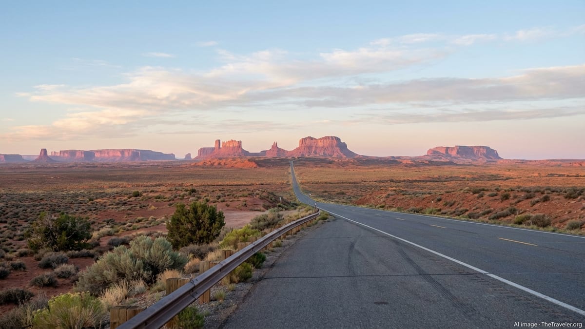
Monument Valley and the Navajo Nation
From Page, or directly from the eastern reaches of the Grand Canyon region, the route can bend northeast toward Monument Valley, one of the most recognizable landscapes in the American Southwest. Towering sandstone buttes rise from a broad, sparsely vegetated valley, their silhouettes familiar from decades of photography and film, yet the scale and depth of color are more compelling in person than any image can fully convey.
Monument Valley lies within the Navajo Nation, and access to key viewpoints and valley floor drives is managed locally. Visitors typically check in at a central visitor complex before proceeding to overlooks or guided tours. A self drive route, when open, allows standard vehicles to follow a graded road among buttes and mesas, while guided tours in local vehicles reach deeper into the valley and provide cultural interpretation alongside the scenery. Guides often share stories that connect specific landforms with Navajo history, tradition and contemporary life.
The quality of light is crucial to experiencing Monument Valley. Sunrise and sunset carve the buttes into sharp relief and paint the valley floor in saturated tones ranging from deep crimson to soft lavender. Midday can be harsh and less flattering for photography, though it is still impressive for appreciating the immensity of the formations. Dust, wind and sudden showers are common, especially in transitional seasons, so bring protective covers for cameras and be prepared for rapidly shifting skies that can produce dramatic cloud formations.
Because Monument Valley is relatively remote and nighttime driving on open reservation roads requires extra caution, many travelers choose to stay nearby. Lodges, inns and small campgrounds in and around the valley offer rooms and sites with views directly onto the iconic buttes. This allows you to rise before dawn to watch first light on the formations and to linger after sunset as stars emerge over the desert. Respect for local regulations and cultural protocols is essential, from staying on designated routes to observing any photography restrictions in certain areas.
Optional Detours and Scenic Byways
Arizona showcases an extensive network of designated scenic roads, and several of these can be woven into this itinerary with modest adjustments in timing. To the south, near Tucson, the Catalina Highway, also known as the Sky Island Scenic Byway, climbs from the Sonoran Desert floor up the flanks of Mount Lemmon. Over roughly 27 miles, it passes through multiple life zones, from cactus and ocotillo to pine and fir forest, offering broad views over the desert and access to cool mountaintop trailheads. If you have additional days and are starting or ending your trip in southern Arizona, this route provides a compelling contrast to the canyon and plateau landscapes farther north.
Another scenic corridor that can be integrated into an extended route is the Joshua Forest Scenic Road designation on a portion of U.S. Route 93 between Wickenburg and Interstate 40. This section of highway passes through a dense stand of Joshua trees, their twisted forms silhouetted against distant ranges. It can be reached by routing your journey between Phoenix and northern Arizona through Wickenburg and Kingman, then continuing toward the high country rather than staying entirely on the interstate system. This adds distance but also variety, especially for travelers who are intrigued by the different expressions of desert vegetation.
Within northern Arizona, shorter scenic roads connect red rock, canyon and high plateau environments. Sections of highway near the Kaibab Plateau, for example, lead through meadows and forests toward the less visited North Rim of the Grand Canyon, which typically opens seasonally. Reaching this rim requires additional driving time and advance planning for limited lodging and services, but travelers who include it in their itinerary often value the quieter viewpoints and the different perspective on the canyon’s breadth.
Because conditions on scenic byways can change due to weather, maintenance or safety improvements, it is important to verify current status close to your travel dates. Some routes include steep grades, hairpin turns or limited shoulders. Others cross remote territory with few services. Carry water, maintain sufficient fuel, and avoid driving unfamiliar winding sections after dark. Integrating these roads into your plan can deepen your understanding of Arizona’s varied landscapes, but they are best enjoyed with unhurried schedules and a focus on safety.
The Takeaway
This Arizona itinerary is less about ticking off a list of famous viewpoints and more about tracing the subtle transitions between ecosystems, elevations and cultural landscapes. From saguaro filled desert basins near Phoenix to the cool forests around Flagstaff, from the sheer depth of the Grand Canyon to the sculpted silhouettes of Monument Valley, each segment contributes a chapter to a larger narrative of stone, water and time.
Traveling by car through these regions allows you to feel how distances open up in the desert and compress again in narrow canyons. It gives you freedom to pull over at unplanned viewpoints, wait out a passing storm or linger when evening light turns ordinary slopes into bands of color. With at least a week and a flexible mindset, you can balance marquee destinations with quieter stops, guided experiences with independent exploration.
Respect for place is an essential companion on this route. Much of the land you cross holds deep significance for Indigenous communities, and many of the most beautiful sites are also fragile. Stay on marked paths, follow local advice and treat both residents and fellow travelers with patience. With thoughtful planning and a willingness to adjust to conditions on the ground, a scenic journey through Arizona’s deserts and canyons can become not only a visually memorable road trip, but also a more nuanced encounter with the American Southwest.
FAQ
Q1. How many days do I need for this Arizona desert and canyon route?
Most travelers are comfortable with seven to ten days, which allows for travel between Phoenix, Sedona, Flagstaff, the Grand Canyon, Page and Monument Valley without rushing.
Q2. What is the best time of year to drive this itinerary?
Spring and autumn usually offer the most pleasant balance of temperatures and daylight, with milder conditions in the desert and comfortable cool weather at higher elevations.
Q3. Can I do this route in a regular rental car?
Yes, a standard two wheel drive rental is suitable for the paved highways and park roads on this itinerary, though some optional back roads and tours use higher clearance vehicles.
Q4. Do I need to book Grand Canyon lodging in advance?
It is strongly recommended, especially for park lodges and campgrounds on the South Rim, which can sell out months ahead during popular travel periods.
Q5. Is this itinerary suitable for families with children?
Yes, but it helps to plan shorter daily drives, frequent stops at viewpoints and simple walks, and to watch children closely near canyon rims and steep drop offs.
Q6. Are there any permits or guided tours I must arrange before arrival?
Guided visits to certain slot canyons near Page and tours in Monument Valley often require advance reservations, and specific hikes elsewhere may need permits that should be secured early.
Q7. How should I prepare for the altitude changes?
Drink plenty of water, rest during your first day at higher elevations such as Flagstaff and the Grand Canyon, and avoid intense exertion until you feel fully adjusted.
Q8. Is it safe to drive these roads in winter?
Many sections remain open, but snow and ice can affect high country passes and canyon rim roads, so check current advisories and be prepared to adjust plans during storms.
Q9. Can I visit both the South Rim and North Rim of the Grand Canyon on this trip?
It is possible on a longer itinerary, but visiting both requires additional driving time and careful planning around the North Rim’s typically seasonal opening and limited services.
Q10. How can I travel responsibly through Indigenous lands on this route?
Observe posted rules, stay on designated roads and trails, support Native owned businesses when you can, and seek locally provided guides for cultural and natural interpretation.