
More news on this day
A powerful atmospheric river is unleashing relentless rain across Metro Vancouver and the Fraser Valley, triggering flooding, landslides, infrastructure damage, and mounting travel disruption as emergency bulletins warn that conditions may deteriorate further through the week.
Get the latest news straight to your inbox!
Record-Breaking Rainfall Overwhelms Rivers and Urban Drainage
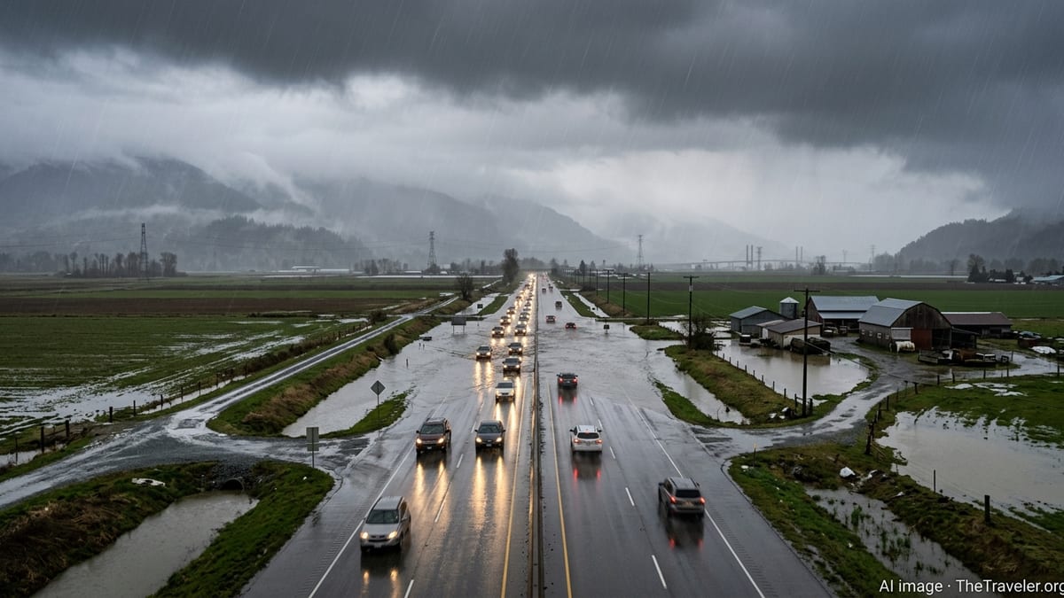
Publicly available forecasts describe an exceptionally moisture-laden storm system funnelling subtropical Pacific air into British Columbia’s South Coast, delivering rainfall totals that approach, and in some locations exceed, records set during past atmospheric river events. Recent coverage indicates that some coastal and mountain areas are facing rainfall projections of 200 to 300 millimetres over several days, with particularly intense bursts over higher terrain north and east of Vancouver.
Hydrological bulletins for the region point to rapidly rising levels on tributaries feeding the Fraser River and to localized flooding on smaller creeks that drain steep mountain slopes into urban neighbourhoods. Low-lying areas in the eastern Fraser Valley, including agricultural lands, are experiencing extensive overland flooding, with fields and rural roads submerged as drainage systems are overwhelmed by runoff.
In Metro Vancouver’s urban core, reports indicate that overwhelmed storm sewers are producing deep ponding at major intersections and on key commuter routes. Municipal updates describe localized street closures, detoured bus routes, and growing concerns about basement flooding in neighbourhoods with older drainage infrastructure or limited pump capacity during high tide and peak runoff.
Along the Fraser River and tidal inlets, elevated river levels are combining with higher seasonal tides to increase seepage and stress on dike systems. Water level monitoring data shared in recent planning documents for the region emphasize that sustained heavy rain, even without a full dike overtopping, can drive prolonged saturation of dike structures and adjacent soils, heightening long-term stability concerns.
Landslides Cut Key Highways and Rail Links
The steep mountain corridors that connect Metro Vancouver to the Fraser Valley and the British Columbia Interior have once again become choke points as saturated slopes shed rock, mud, and debris onto highways and rail lines. Provincial travel advisories describe multiple debris flows and landslides affecting routes such as Highway 1 through the Fraser Canyon, Highway 7 along the north side of the Fraser River, and critical east-west connections that carry both passenger and freight traffic.
Published coverage notes that several slides have partially or fully buried sections of roadway, damaging guardrails, culverts, and bridge approaches. In some locations, crews are reported to be working in narrow valley bottoms where unstable slopes rise directly from the highway shoulder, a configuration that proved particularly vulnerable during the destructive atmospheric river sequence in 2021.
Rail operators serving the Lower Mainland are also grappling with track washouts and rockfalls in canyon segments where lines run close to riverbanks and below steep bluffs. Industry updates describe speed restrictions, inspections, and temporary suspensions of service along compromised sections, raising concerns about delayed shipments through the Port of Vancouver and ripple effects across national supply chains.
Transportation planners and hazard assessments for the region have long warned that a major storm striking saturated or fire-affected slopes can trigger a cascade of slope failures. Current conditions are reinforcing those concerns, with reports of fresh scarps above highways, toppled trees loosening surrounding soils, and debris-choked culverts redirecting runoff into new channels that undercut roadbeds.
Air, Ferry, and Local Transit Disrupted as Travel Chaos Spreads
While the most dramatic impacts are unfolding on mountain highways and rural roads, the storm is also reshaping daily travel patterns across the broader Metro Vancouver area. Flight-tracking data and airport status notices show waves of delays and cancellations at Vancouver International Airport as strong crosswinds, low cloud ceilings, and heavy rain reduce arrival and departure capacity.
On the water, coastal weather statements highlight strong winds, rough seas, and reduced visibility in the Strait of Georgia and surrounding channels. Ferry operators on major routes linking the Lower Mainland with Vancouver Island and the Gulf Islands have posted warnings about possible sailing delays or cancellations, complicating travel plans for residents and visitors at the start of the spring break period.
Within the metropolitan area, public transit agencies report detours on bus routes where surface flooding or downed trees have blocked lanes. In some hillside neighbourhoods, minor slides and debris on local streets are affecting smaller community shuttles. Rail-based rapid transit systems are generally less exposed to direct flooding, but operations staff are monitoring for localized power interruptions, overhead line issues, and water infiltration at low-lying stations.
Motorists who choose to travel despite repeated advisories are encountering pooling water, deep potholes emerging in saturated pavement, and sudden closures as crews move in to clear drains or remove debris. Insurance industry briefings following previous atmospheric rivers in the region have highlighted a pattern of vehicle damage, from flooded engines to collisions on slick roads, that tends to surge during multi-day storm events of this magnitude.
Communities Revisit Trauma of 2021 as Preparedness Measures Tested
The unfolding deluge is reviving difficult memories across communities that were hit hard by the catastrophic 2021 atmospheric river, which severed highway links, inundated the Sumas Prairie, and triggered deadly landslides in mountain passes. Local media coverage and municipal updates note a palpable anxiety in Fraser Valley farming areas and hillside towns that are once again watching rivers rise and listening for updates on slope stability along critical escape routes.
Since 2021, regional planning documents and engineering reports have catalogued an array of upgrades and interim measures designed to reduce the risk of a repeat disaster. These efforts include targeted dike repairs and heightening in vulnerable stretches, expanded debris-flow monitoring in high-risk gullies, and refined evacuation mapping that takes into account the possibility of multiple simultaneous highway closures.
The current storm is providing an early test of those investments. Public information from regional districts and municipalities indicates that some newly reinforced dikes and pump stations are operating near capacity, while upgraded culverts and debris basins are being closely watched during peak runoff periods. Early observations from hydrologists and emergency planners, shared through open reports and public briefings, suggest that while damage is occurring, some upgraded structures are performing closer to their design expectations.
At the household level, many residents in low-lying or slide-prone zones appear more prepared than in past events, based on survey data and anecdotal reporting from community organizations. Sandbagging efforts, pre-packed go bags, and informal neighbourhood support networks are more visible, reflecting a wider recognition that extreme rainfall events are becoming more frequent and intense in a warming climate.
Climate Change, Infrastructure Gaps, and the Future of Travel in B.C.
Climate assessments for British Columbia and the broader Pacific Northwest consistently project an increase in the intensity of winter and shoulder-season storms, including atmospheric rivers capable of delivering extraordinary amounts of rain and high-elevation snow in short windows. Recent government and academic studies point to a growing overlap between these extreme precipitation events and other stressors, such as post-wildfire slope instability and aging transportation infrastructure.
For the travel sector, the latest storm underscores how quickly access to and within the Lower Mainland can be compromised when multiple routes are simultaneously affected by flooding and slides. Scenario planning documents prepared for the region describe the risk of Metro Vancouver becoming temporarily isolated by road if all key corridors to the Interior are disrupted, a situation that has now occurred more than once within a decade.
Policy discussions captured in recent infrastructure and climate-adaptation reports focus on options ranging from strategic highway realignments away from the most slide-prone slopes to expanded redundancy in rail, road, and coastal shipping routes. There is also increasing interest in nature-based solutions, such as wetland restoration in historic floodplains and improved forest management in critical headwaters, to help slow runoff and reduce downstream flood peaks.
As the present atmospheric river continues to drench southwestern British Columbia, the combination of flooded streets, stranded travelers, and battered infrastructure is reinforcing a broader debate about how quickly the province can adapt its transportation and land-use systems to a stormier future. For residents, commuters, and visitors caught in the middle of this week’s deluge, that debate has become an immediate and highly tangible reality.