
Bernkastel-Kues is the kind of Moselle town that looks as if it were drawn on a storybook map. Half-timbered houses lean over cobbled lanes, vineyards climb almost impossibly steep slopes, and the wide sweep of the river ties it all together. To make the most of it, you need more than just directions from A to B.
You need a mental map that shows how the old town, the vineyards, and the riverfront fit together, and how to navigate between them on foot, by bike, or with local transport. This guide lays out that map in words, helping you visualize and plan your time in Bernkastel-Kues with confidence.
Understanding the Layout of Bernkastel-Kues
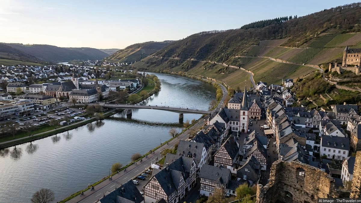
Seeing everything mapped out makes the things to do in Bernkastel-Kues easier to organize. Bernkastel-Kues sits on both banks of the Moselle in the German state of Rhineland-Palatinate, roughly midway between Trier and Koblenz. The Moselle flows in a broad S-curve here, with steep slate hills rising on both sides.
On the right bank you find Bernkastel, the historic half-timbered town crowned by the ruins of Burg Landshut high above. On the left bank lies Kues, more spacious, residential, and practical, with parking, supermarkets, and easy access to the vineyards. The two halves are joined by a single road bridge that becomes the key crossing point in almost any walking route.
The town is compact enough that you can cross from one side to the other on foot in around 10 to 15 minutes, but varied enough that each district feels distinct. Bernkastel is where you spend time getting lost in medieval alleys, pausing at wine taverns, and photographing the market square. Kues is where you often arrive, park, stay in a hotel, and then either stroll the riverfront or climb through the vineyards. Thinking of them as two complementary sides of one place is the first step in orienting yourself.
Overlaying this is the vertical dimension. The Moselle sits at the valley floor, flanked by the riverfront promenades and the main roads. Above that, like a tilted amphitheater, the famous Moselle vineyards rise up in tight terraces. Higher still, the wooded ridge known as the Olymp and the spur bearing Burg Landshut form the skyline on the Bernkastel side. Much of the local walking and hiking consists of moving between these three levels: river, vineyards, and ridge, often in short zigzag paths that can be steep but richly rewarding.
Maps also help set expectations when comparing Bernkastel-Kues vs Cochem. Finally, it helps to know that Bernkastel-Kues is part of a larger holiday region, with small wine villages up and downriver. River cruises, cycling routes, and bus services link it to neighbors like Zeltingen, Graach, and Wintrich. For most visitors, though, the core experience is contained within a remarkably small radius, where a 20-minute stroll can carry you from a quiet vineyard lane to a bustling medieval square and on to the riverside in a seamless loop.
The Old Town of Bernkastel: A Walkable Medieval Map
The historic center of Bernkastel lies just inland from the Moselle, set back a short distance from the riverfront road. The heart of this old town is the medieval marketplace, a compact square ringed by timber-framed facades, the pointed Renaissance town hall, and the famous Spitzhäuschen, a narrow house that seems to balance on its own ground floor. From this square, short lanes radiate out like spokes on a wheel, each offering a different perspective on the town’s history.
A practical way to imagine the old town is as a tier of three rough bands running parallel to the river. The lowest band is the riverside road and promenade, with the Mosel Guest Center and boat landings. A block inland lies the market square level, slightly elevated and more sheltered, where shops, wine bars, and cafes cluster. Above that, narrow streets climb toward St Michael’s Church, the Graacher Tor gate, and the modest remains of old defensive walls, before finally giving way to paths and trails heading uphill to Burg Landshut.
For orientation on foot, two landmarks help anchor your internal map. St Michael’s Church, with its tower looming over the roofs, marks the uphill edge of the old town and is visible from many points along the riverfront. The Graacher Tor, an old city gate, is another reference point at the northern exit of the center. If you can find your way between the marketplace, the church, and the gate, you have essentially mastered the pattern of Bernkastel’s internal streets.
Time-wise, you can circle the core of the old town in 20 to 30 minutes at a relaxed pace, but the charm lies in detours: slipping into side alleys hung with grapevines, browsing small wine shops, and emerging unexpectedly at another angle on the square. The streets are largely cobbled and, while not car-free, are heavily traffic-calmed, which encourages slow walking. Elevation changes are modest in the town itself, though you will notice gentle climbs as you drift away from the river toward the hillside.
Vineyards and Viewpoints: Mapping the Slopes Above Town
One of the defining features of Bernkastel-Kues is how abruptly vineyards rise above the roofs. Looking at a map or satellite image, you see the fields of vines pressing right up against the last houses, then clinging to the hill as they fan out in geometric lines. Many of these plots belong to well-known Moselle estates, and wine labels you might know from home originate from the very slopes you see above the town.
The principal vineyard zone directly above Bernkastel lies between the old town and Burg Landshut. Here, paths and service tracks snake through the vines, often unpaved and steep. From the marketplace area, you can follow signposted routes such as the family-friendly city circular walk that leads through the alleys, along the Tiefenbach stream, and then up toward the castle with vineyard views opening out as you climb. The route is only around four kilometers in total and typically takes about one and a half hours, making it manageable for most visitors who are comfortable with some ascent.
Higher up, Burg Landshut occupies a prominent spur jutting out from the broader Olymp ridge. Reached on foot in around 20 to 30 minutes from the old town, it offers a panoramic map of the Moselle valley you have just walked through. From its terraces you see the bend of the river, the compact knot of Bernkastel’s rooftops, the more sprawling Kues district opposite, and the patchwork of vineyards continuing in both directions along the valley. The view is especially striking at sunset, when the slate and stone glow warm tones and the patterns of the vineyards become more pronounced.
If you look inland from the castle, you see how quickly the land transitions from vineyards to forest. The Olymp itself rises to a height of just over 400 meters, a wooded crest that stands roughly 300 meters above the river. Hiking routes lead from Bernkastel through the Tiefenbach valley, sometimes romantically referred to as the “Bernkasteler Schweiz,” and on to the Hunsrück plateau beyond. Most visitors, however, confine their time to the lower loops through vines and castle paths. These are enough to deliver the classic Moselle combination of exercise, landscape, and the constant presence of wine.
Life Along the Riverfront: Promenades, Bridges, and Boat Landings
The Moselle is the organizing axis of Bernkastel-Kues. On both banks, riverside promenades provide a flat, scenic spine that ties together old town, modern amenities, and transport points. On the Bernkastel side, the promenade runs near the large Mosel parking area and the Mosel Guest Center, then continues past boat jetties and benches toward neighboring villages. On the Kues side, a similarly pleasant walkway traces the Nikolausufer and Moselufer, giving access to parking areas, hotels, and open lawns.
The main road bridge, located roughly level with the old town, functions as the central hinge between these two promenades. Standing here, you have some of the classic views of both halves of Bernkastel-Kues. To one side lies the concentrated mass of Bernkastel’s gables, with Burg Landshut perched seemingly straight above them. To the other, Kues spreads out more gently with its riverside buildings and the silhouette of St Nikolaus Hospital and its associated structures a short distance inland. Crossings are quick, and pedestrian walkways on the bridge make it easy to shift from one bank’s promenade to the other.
For river transport, seasonal boat services link Bernkastel-Kues with other Moselle towns, and short sightseeing cruises operate from landings near the old town. These are usually clearly signposted along the Bernkastel promenade. While full timetables change season by season, most operate daily in high season from spring through autumn, offering trips both up and down river. For planning your day, it helps to mentally place the boat landings just a few minutes’ walk from the marketplace, slightly downriver from the bridge on the Bernkastel side.
Even without getting on a boat, the riverfront serves as an easy orientation tool. If you are unsure where you are in town, walk downhill until you reach the Moselle, then follow the promenade until you see either the bridge or the Mosel Guest Center. The river always runs between Bernkastel and Kues, with the main bridge connecting the two central districts. This simple rule, combined with the visual anchor of Burg Landshut on the ridge, is often enough to re-orient even first-time visitors.
Practical Map: Arrival, Parking, and Getting Around
Approaching Bernkastel-Kues by car, you generally follow the B 53 road that traces the Moselle valley. The town is compact, and local authorities have concentrated most visitor parking along the riverbanks and in a central garage. On the Bernkastel side, the large Mosel parking lot near the river offers hundreds of spaces and stands only a few minutes’ walk from the old town streets. This makes it a natural choice if your priority is to explore the medieval center without having to navigate narrow lanes by car.
On the Kues side, several parking areas line the Nikolausufer and Moselufer, providing convenient access to both the riverfront promenade and the bridge into Bernkastel. Some of these are mid-sized lots accommodating around 40 to 100 cars, with ticket machines and the option of long-term passes valid over multiple days or weeks. As of the latest information, parking fees are generally charged from April 1 to December 31, daily from morning to early evening. At other times, or outside the fee hours, parking is often free, but drivers should always check on-site signage before leaving their vehicle.
For visitors with limited mobility, designated spaces are reserved in the main riverside lots, and local regulations typically allow holders of valid disability permits to use standard spaces with fee reductions or exemptions when the appropriate documentation is displayed. Motorcyclists benefit from specific free parking zones near the river, while in regular car spaces standard tariffs apply. Electric vehicle drivers will find multiple public charging points distributed between Bernkastel and Kues, some near banks or central areas.
Once parked, you are unlikely to need your car again for local exploration. Distances are short: walking from Kues across the bridge to the Bernkastel marketplace can take as little as 10 to 15 minutes. The official Mosel Guest Center in Bernkastel acts as both information hub and navigational anchor, with staff able to provide paper maps and up-to-date details on walking routes, bus timetables, and seasonal services. Public buses connect Bernkastel-Kues with surrounding villages and with larger hubs in the region, but within the twin town itself, your feet and perhaps a rented bicycle will probably be your main means of transport.
Classic Walking Routes that Connect Town, Vines, and River
Understanding Bernkastel-Kues through its walking routes is one of the best ways to turn a flat printed map into a lived, three-dimensional experience. Fortunately, several well-marked circuits link the riverfront, the old town, and the vineyards in logical loops, many of them beginning at or near the Mosel Guest Center on the Bernkastel side. This central starting point is easy to find along the riverside and particularly convenient if you have just parked in the nearby Mosel lot.
A popular choice is the family circular city walk, a roughly four-kilometer loop graded as moderate and designed to showcase key sights within a compact area. Starting by the river, it weaves through Bernkastel’s alleys toward the marketplace, offers views of St Michael’s Church and half-timbered facades, and then traces the Tiefenbach valley past a small waterfall and chapel before climbing to Burg Landshut. From the castle, the route returns toward the town with sweeping views of the river bend. Time estimates hover around one and a half hours, but photo stops and detours can easily extend that.
Another simple mental map is the horizontal promenade route that crosses the bridge. Beginning in Kues, you can walk along the Nikolausufer, pass parking areas and riverside lawns, reach the bridge, cross with views of Burg Landshut, and then continue on the Bernkastel promenade past boat landings and the Mosel Guest Center. From there, it is only a few minutes up into the market square, or you can stay along the river to extend your walk toward neighboring villages. This flat, largely level path is ideal for travelers who prefer to avoid steep climbs while still gaining a strong sense of the town’s layout.
More ambitious hikers can turn the Burg Landshut ascent into the beginning of a longer excursion toward the Olymp ridge and beyond, making use of signposted regional trails. These routes quickly move from cultivated vineyard terraces into mixed woodland, with occasional clearings that offer back-views over the Moselle valley and Bernkastel-Kues below. It is worth noting that while paths are generally well marked, gradients can be sharp, and solid footwear is essential. Before setting off on longer hikes, it is advisable to check conditions and recommendations at the tourist information center.
Key Sights and How They Fit on Your Mental Map
A handful of landmarks provide reliable reference points as you navigate Bernkastel-Kues. Foremost among them is Burg Landshut, the castle ruin perched directly above Bernkastel. From almost anywhere along the riverfront or within the old town, you can look up and see its walls and flags, reminding you where “uphill” lies. On your internal map, place it at the apex of a triangle whose base is the riverfront and whose sides are the steep lanes and paths winding up through the vineyards.
At river level on the Bernkastel side, the Mosel Guest Center and adjacent large parking area form another anchor. Here you find tourist information, restrooms, and often the starting points of guided tours. A short inland step brings you to the marketplace with its fountain, Renaissance town hall, and the well-known Spitzhäuschen. This triad of Mosel Guest Center, marketplace, and Burg Landshut gives you a clear vertical progression: river, town, castle. If you can move confidently between these three, you are well oriented.
Across the river in Kues, the St Nikolaus Hospital and its associated Cusanusstift complex occupy a significant spot a few minutes’ walk inland from the riverfront. Founded in the 15th century as a charitable institution, it still functions today and houses a library and museum. On your mental map, you can think of it as the cultural counterpart to Bernkastel’s old marketplace: a point a little removed from the river, associated with history and scholarship rather than commerce and hustle.
Smaller but still helpful reference points include the Graacher Tor gate at the northern edge of Bernkastel’s old town and the bridge itself, which sits approximately opposite the central cluster of old streets. By linking these spots in your head – castle above, marketplace and church mid-level, riverfront and bridge below, with Kues and the hospital across the water – the seemingly intricate patterns of alleys and paths resolve into a clear and memorable layout.
The Takeaway
Bernkastel-Kues rewards travelers who approach it as more than a single postcard view. The town reveals its character gradually as you move between the Moselle’s broad curve, the tight weave of medieval streets, and the airy openness of the vineyards and ridge above. Understanding how these layers relate to one another turns a simple stroll into a coherent journey, where every turn makes sense on your internal map.
By picturing Bernkastel as the historic right-bank hub and Kues as the more spacious left-bank counterpart, linked by a single bridge and laced together with promenades, you gain a practical framework for planning your days. Add in the vertical axis from river to castle and onward to the wooded Olymp, and you have a complete three-dimensional sense of place. Whether you are following a marked circular walk, climbing to Burg Landshut for sunset, or simply wandering between wine bars, this mental map helps you move with confidence.
Most of all, Bernkastel-Kues remains delightfully walkable. Once you have parked along the river, almost everything lies within a short, scenic stroll. With a bit of advance orientation and an openness to getting pleasantly sidetracked, you can explore its old town, vineyards, and riverfront in a way that feels both intuitive and deeply rooted in the landscape that has shaped this Moselle community for centuries.
FAQ
Q1. How long does it take to walk from Kues to the Bernkastel old town?
Most visitors can walk from the central riverfront of Kues across the bridge to the marketplace in Bernkastel in about 10 to 15 minutes, depending on pace and photo stops along the way.
Q2. Where is the best place to park for visiting the old town?
If your main goal is to explore the historic center, the large riverside parking area on the Bernkastel side is usually the most convenient, as it lies only a few minutes’ walk from the Mosel Guest Center and the entrance to the medieval streets.
Q3. Is the climb to Burg Landshut very difficult?
The path to Burg Landshut is short but fairly steep. Most reasonably fit visitors can make the climb from the old town in 20 to 30 minutes, but you should wear sturdy shoes, take your time on the steeper sections, and be prepared for uneven surfaces.
Q4. Are the riverside promenades suitable for strollers and wheelchairs?
The promenades on both the Bernkastel and Kues sides of the Moselle are generally flat and paved, making them suitable for strollers and, in many sections, for wheelchairs or mobility aids. Some access points and older sections may have minor obstacles, so checking the route ahead is advisable.
Q5. Do I need a car to get around Bernkastel-Kues?
Within the town itself, you do not need a car. Once you have parked, almost everything of interest is reachable on foot, and local buses or taxis can help with any longer connections. A car is most useful for reaching neighboring villages or exploring the broader Moselle and Hunsrück region.
Q6. When are parking fees usually charged?
According to current local guidelines, parking fees on the main visitor lots are typically charged from April 1 to December 31, usually between morning and early evening hours. Outside these periods or times, parking may be free, but it is important to confirm details on the posted signs in each lot.
Q7. Can I visit the vineyards directly from the town?
Yes, one of the charms of Bernkastel-Kues is how quickly you can step from town streets into vineyard paths. From the upper edges of the old town or from certain points in Kues, short signposted routes lead directly through the vines toward viewpoints and the approaches to Burg Landshut.
Q8. Where can I get a detailed map of walking routes?
The Mosel Guest Center on the Bernkastel riverfront provides printed maps and brochures showing local walks, vineyard paths, and hiking routes to Burg Landshut and beyond. Staff there can also advise on difficulty levels, estimated times, and current trail conditions.
Q9. Is Bernkastel-Kues a good base for exploring other Moselle towns?
Yes, its central location on the Middle Moselle, combined with river cruises, regional bus services, and cycling routes, makes Bernkastel-Kues an excellent base for day trips to nearby wine villages and scenic stretches of the valley.
Q10. What is the best way to orient myself quickly on arrival?
A useful method is to first find the river and note the position of the bridge and Burg Landshut above Bernkastel. From there, locate the Mosel Guest Center on the Bernkastel promenade for maps and advice. Once you understand this triangle of river, bridge, and castle, the rest of the town’s layout becomes much easier to grasp.