
Cologne rewards curious travelers who are willing to slow down, look up, and follow the curve of the Rhine. On a map, the city center seems disarmingly compact: the Gothic spires of Cologne Cathedral rising beside the main station, the Old Town fanning out in a patchwork of medieval lanes, and the riverfront promenade stretching south toward repurposed harbor cranes and sleek glass museums. Yet within this small radius lie centuries of history, layered architecture, and a walkable urban landscape that is easy to navigate once you understand how the pieces fit together and makes the things to do in Cologne easier to plan.
Understanding the Layout: Reading the Cologne City Map
The historic heart of Cologne is effectively a triangle bordered by the Rhine on the east, the semi-circular Cologne Ring on the west, and a northern and southern taper where old fortifications once stood. Inside this area lie the Old Town districts, divided into Altstadt-Nord around the cathedral and Altstadt-Süd as you follow the river downstream. Nearly everything a first-time visitor wants to see in Cologne maps neatly into this central pocket, which can be crossed on foot in 20 to 30 minutes. It helps visualize differences when comparing Cologne vs Düsseldorf.
Cologne Cathedral marks the geographic and emotional center of the city map. Immediately west stands the main rail hub, Köln Hauptbahnhof, while the cathedral square spills eastward to a terrace that looks down on the Rhine. From here, bridges link the city center to the right bank neighborhoods, but most short-stay visitors will spend the bulk of their time on the left bank between the cathedral and the riverfront. Major shopping streets run south from the cathedral into the Old Town, while the riverside promenade traces a clear north-south line along the water.
Orientation becomes simpler once you understand how the Cologne Ring functions. This broad boulevard arcs around the western edge of the Old Town on the footprint of demolished medieval walls. Everything inside the curve belongs to the historic core, with its dense network of cobbled streets and church towers. Everything outside belongs to the later Neustadt and residential districts. When you see the traffic of the Ring and its large intersections, you know you are leaving or re-entering the compact Old Town map.
Public transport overlays this simple geography with a straightforward network. S-Bahn and regional trains funnel into the main station beside the cathedral, while tram and light-rail lines ring the center and cross beneath the Rhine. For a short stay focused on the Old Town and riverfront, most journeys are walkable, but understanding the rough alignment of tram stops with landmarks on the map gives you flexibility in bad weather or at the end of a long day.
Cologne Cathedral in Context: The Spiritual and Spatial Anchor
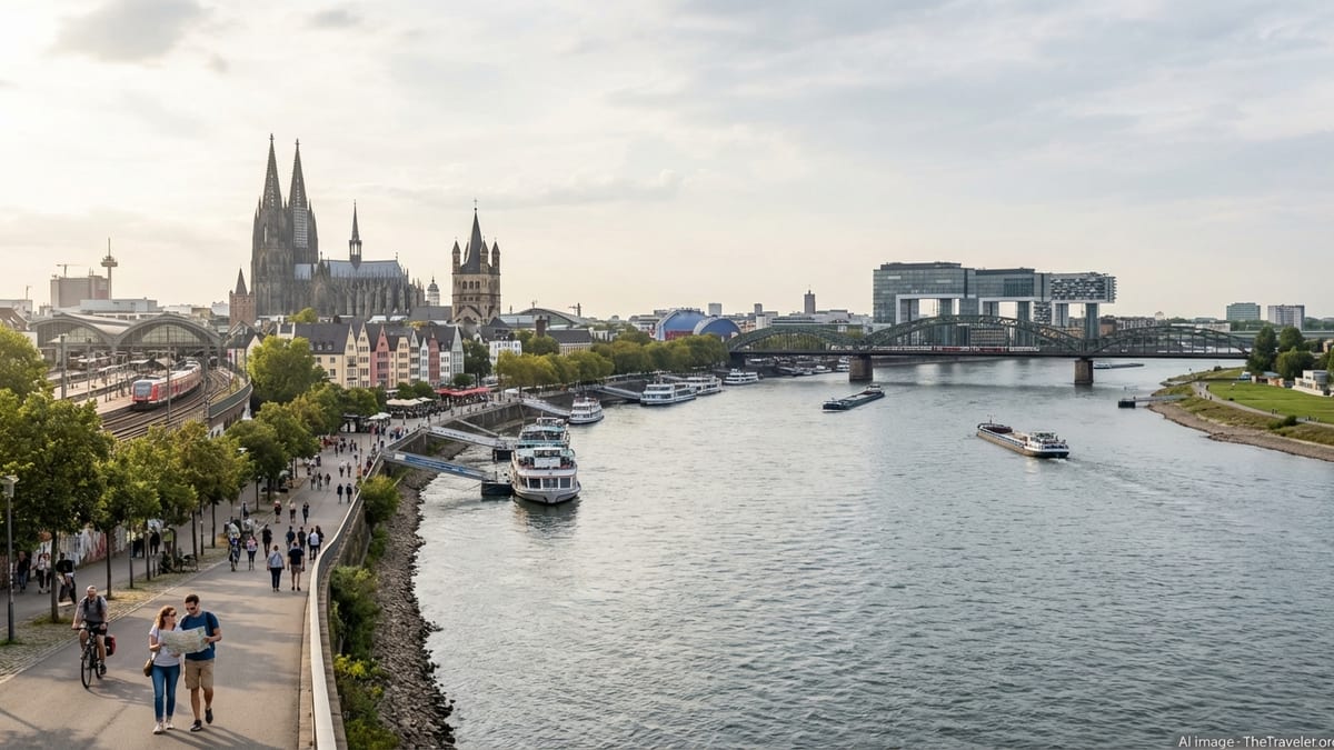
Cologne Cathedral is more than a visual icon; it is the city’s most reliable compass point. The twin spires dominate the skyline and, on any central map or navigation app, form the zero point from which distances and directions radiate. Completed in the 19th century to medieval designs after more than six centuries of intermittent construction, the cathedral anchors a plateau of plazas and terraces that connect rail, river, and Old Town in one continuous urban sequence.
Arriving by train at Köln Hauptbahnhof places you within moments of the cathedral’s western doors. Step out of the station and you are greeted by the massive façade directly opposite. Pedestrian routes radiate from this square: walk east and stairs lead down to the Rhine embankment; walk south and you are instantly in the shopping streets that thread into the Old Town; walk west and you cross into the newer commercial districts beyond the Ring. For visitors navigating by paper map, this junction is the clearest starting point.
Planning a cathedral visit becomes easier when mapped against the flow of the day. The nave is free to enter, while the tower climb and treasury require tickets and a bit of stamina. The tower’s 533 steps spiral up one of the spires without an elevator, and the ascent, which typically takes about 45 to 60 minutes round-trip, is best tackled earlier in the day when crowds and temperatures are lower. From the viewing platform, the map of Cologne unfolds in three dimensions: the Old Town roofs clustered along the Rhine, the arc of the Ring, the bridges stepping across the river, and the more modern districts fanning out beyond.
Time your cathedral visit so that it anchors, rather than interrupts, your exploration of the surrounding city. One effective approach is to start at the cathedral in the morning, explore the interior and tower, then drop down to the Rhine to walk the riverfront. Later in the day you can loop back through the Old Town lanes and end at one of the traditional brewhouses near the cathedral, using its illuminated towers as a nighttime landmark guiding you back to your hotel or train.
Mapping the Old Town: Altstadt-Nord and Altstadt-Süd
On a map, Cologne’s Old Town splits into two distinct zones north and south of the cathedral, separated more by mood than by hard borders. Altstadt-Nord wraps around the cathedral and main station with a concentration of museums, shopping streets, and squares, while Altstadt-Süd stretches along the river with a more relaxed sequence of churches, beer halls, and pastel houses overlooking the promenade.
Altstadt-Nord is where the city’s cultural institutions cluster within a few minutes’ walk of one another. West of the cathedral, the Museum Ludwig’s bold modernist form and the Roman-Germanic archaeological collection occupy plots that once marked the Roman frontier. To the south run Hohe Straße and Schildergasse, two of Germany’s busiest pedestrian shopping streets, tracing the line of the Roman Cardo and connecting the cathedral to the Ring. These streets can be crowded, but they are efficient, straight routes that slice through the map and lead you quickly between landmarks.
Shift your focus south of the cathedral and the city’s character softens. Altstadt-Süd hugs the Rhine, its narrow lanes lined with traditional houses painted in bright colors and stepped gables. Here sit Great St. Martin Church with its distinctive tower, the historic City Hall with its Gothic tower and Renaissance loggia, and a concentration of brauhäuser where Kölsch beer is served in tall, narrow glasses. From a mapping perspective, this area forms a strip between the riverfront promenade and the Ring, tapering as you head south toward the redeveloped harbor district of Rheinauhafen.
Because of bombing during the Second World War and postwar reconstruction, much of the Old Town’s historic appearance is a careful reimagining rather than untouched medieval fabric. Nonetheless, the street plan preserves many historical axes and alleyways. When you follow a map, you are often tracing routes that existed in Roman times or the Middle Ages, even if the facades have changed. Allow extra time in your itinerary to wander off the direct line between sights; the Old Town’s charm lies in serendipitous courtyards, hidden shrines, and small river views framed by houses.
The Rhine Riverfront: From Dom Terrace to Rheinauhafen
The Rhine frames Cologne’s eastern edge and gives the city map its defining curve. Standing on the terrace below the cathedral and looking east, you see the wide flow of the river and the iron arches of the Hohenzollern Bridge, heavy with commuter trains and colorful love locks. Turn south, and the riverfront becomes a continuous pedestrian promenade that runs for kilometers along the left bank, flanked by cafés, lawns, and landing stages for cruise boats.
For visitors, the most engaging stretch of the Rhine promenade lies between the cathedral terrace and the redeveloped Rheinauhafen district. North of the Old Town, the riverfront is functional and open, with long views and moored barges. As you walk south, the promenade tightens against the pastel facades of Altstadt-Süd, creating one of the city’s most photographed street scenes. Here you can step away from the water into narrow alleys that cut back to Groß St. Martin or the Alter Markt, then return to the riverfront without losing your sense of direction.
Continue south on the map and the skyline begins to shift. The outline of Great St. Martin gives way to the brick mass of the Chocolate Museum and the low, elongated halls of the German Sport & Olympic Museum. Beyond them, the promenade passes under a series of striking crane-shaped towers in Rheinauhafen, where old harbor warehouses have been converted into offices, apartments, and eateries. This zone, about 15 to 20 minutes’ walk from the cathedral, offers a contrast to the Old Town’s medieval references: glass, steel, and wide minimal plazas framed by the ever-present river.
Boat trips on the Rhine use this riverfront geography as both stage and map. Short sightseeing cruises typically depart from piers near the Old Town, pass under the city’s bridges, and loop around islands and neighboring districts. From the water, you gain a different understanding of Cologne’s layout: how the Old Town huddles close to the cathedral, how the Ring separates old from new, and how the right bank neighborhoods mirror the left with their own promenades, high-rises, and parks.
Navigating with Transit: Trams, Trains, and the KölnCard
While central Cologne is easily explored on foot, integrating public transport into your mental map extends your reach and saves time. The main station, sitting beside the cathedral, serves long-distance and regional trains, as well as S-Bahn lines that skirt the river and connect to suburbs and the airport. Beneath and around the city center, the Cologne Stadtbahn network combines tram and light-rail functions, with lines surfacing in some streets and running underground in others.
For visitors, the most useful tram and light-rail stops cluster in and around the Old Town. Dom/Hbf serves the cathedral and main station; Heumarkt covers the southern Old Town and riverfront; Neumarkt sits at a key intersection of shopping streets and the Ring slightly to the southwest. These nodes become anchors on your map, allowing you to jump between the Old Town, modern commercial quarters, and residential neighborhoods further out. Services are frequent during the day, with short waits between trains on most lines.
The KölnCard simplifies both navigation and budgeting for short stays. Offered by the city’s tourism authorities, the card provides unlimited use of local public transport within Cologne’s urban area for 24 or 48 hours, along with discounts at museums, attractions, and some tours and restaurants. Current pricing typically places a 24-hour individual card in the range of the low double digits in euros, with a modest increase for 48 hours and group options for up to five people. You can buy the card at the main tourist information office near the cathedral, via ticket machines, or through partner apps, then activate it when you first travel.
Overlaying the transit network onto your city map is straightforward. Imagine the Rhine running north to south, the Old Town pressed against its left bank, and the Ring forming a semicircle to the west. S-Bahn lines track the river, tying the main station to outlying districts and neighboring cities. Stadtbahn lines slice across this structure, passing under the Old Town and along the Ring. With a basic sense of this pattern and a valid KölnCard in your pocket, you can move fluidly between cathedral, Old Town, riverfront, and neighborhoods like the Belgian Quarter and Ehrenfeld without needing a car.
Planning Classic Walking Routes Around Cathedral, Old Town, and Rhine
Cologne’s city map invites you to plan walks that combine landmark sightseeing with everyday urban life. One classic loop starts at the main station, visits the cathedral interior and, if you wish, the tower, then drops down to the Rhine terrace. From here, follow the river south with the Old Town on your right. After ten minutes, you reach the pastel houses and eateries near Great St. Martin and the Old Market. Cut inland to wander the squares and side streets, then return to the river near the Chocolate Museum and continue to Rheinauhafen’s contemporary architecture.
A second route focuses more on the Old Town’s internal structure. Begin again at the cathedral, but this time walk directly south along Hohe Straße, absorbing the commercial energy of one of Cologne’s busiest pedestrian streets. At the intersection with Schildergasse, you can veer west toward Neumarkt and the Ring, or east to return to the river via narrow alleys that suddenly open onto church squares or small courtyards. This route shows how the Roman street grid still influences modern traffic and how, even in the heart of the shopping zone, low-rise buildings and church towers maintain a human scale.
For a larger loop, connect the riverfront and Ring. Start at the cathedral, descend to the Rhine, and stroll south to the Old Town’s southern edge. Turn inland until you reach the broad traffic of the Ring, then follow it north, passing historic city gates and lively squares where trams oscillate between surface and tunnel. Eventually, you curve back toward the cathedral from the west, closing the circle and confirming how compact the central district really is. Along the way, side streets lead off into the Belgian Quarter and other neighborhoods, inviting detours for coffee, galleries, and quieter residential architecture.
These walking routes are easy to adapt to weather and time. In summer, more of your map may be along the riverfront, where breezes and green patches soften the heat. In colder months, the dense Old Town streets and museums near the cathedral offer more indoor stops while still keeping you close to the Rhine’s changing light. By sketching a rough route on a paper map or mental plan before setting out, you avoid retracing your steps unnecessarily and gain a clearer sense of how Cologne’s pieces click together.
Staying in the Center: Mapping Accommodation to Experience
Where you stay in Cologne significantly shapes how you experience the city map. Hotels directly around the cathedral and within Altstadt-Nord put you at the center of everything: you step out into a landscape of spires, plazas, and museums, with the riverfront and shopping streets only minutes away. This convenience comes at a premium, as room rates in this core area are higher and the narrow streets can be lively well into the evening, especially around popular brewhouses.
Continue to trace the map outward and you find slightly quieter options that still keep you within easy walking distance of the Old Town and Rhine. Altstadt-Süd, stretching along the river below the Old Town core, offers a mix of traditional guesthouses and modern hotels, with some rooms facing the water or looking back to the cathedral’s silhouette. The walk to the main sights is scenic, following the promenade or weaving through lanes that feel distinct from the shopping-focused north.
Beyond the Ring, neighborhoods such as the Belgian Quarter and parts of Neustadt-Nord and Neustadt-Süd provide a different kind of centrality. On the map, they ring the Old Town like a second layer, connected by trams and broad avenues. Staying here trades postcard views of the cathedral for street life centered on independent cafés, boutiques, and evening bars. You still reach the Rhine and Old Town in 10 to 20 minutes by foot or tram, but your immediate surroundings are less tourist-heavy and more representative of everyday Cologne.
When choosing accommodation, use the city map to think in terms of circles rather than specific streets. How far are you willing to walk to the cathedral or the Rhine promenade. How close do you want to be to a major tram stop or the main station. Once you mark these points, you can see whether a hotel’s location aligns with your priorities. The compact layout means that even a property slightly off the usual tourist axis may still be more convenient than it appears at first glance.
The Takeaway
Cologne is one of those European cities where a modestly sized map contains an outsized concentration of experiences. Within a few square kilometers you can stand beneath one of the continent’s great Gothic cathedrals, trace the line of Roman streets beneath your feet, sip local beer in centuries-old taverns, and stroll a modern riverfront framed by repurposed harbor cranes and glass towers. Understanding how the Old Town, cathedral, and Rhine riverfront interlock helps you move confidently through this landscape rather than simply following crowds from one marquee sight to the next.
If you picture Cologne’s center as a triangle of cathedral, Old Town, and river, with the Ring as a loose boundary and the transit network threading through, you have the essential structure you need. From there, it becomes a matter of tracing your own routes: lingering in Altstadt-Süd’s colorful lanes, crossing the Hohenzollern Bridge for skyline views back to the cathedral, or meandering along the promenade toward Rheinauhafen as the evening light settles over the river. With a bit of pre-trip map reading and the flexibility of walking shoes or a KölnCard in your pocket, Cologne quickly shrinks from an unknown city into an inviting neighborhood that feels easy to inhabit, even on a short stay.
FAQ
Q1: How long does it take to walk from Cologne Cathedral to the Rhine riverfront.
In normal conditions, it takes about five minutes to walk from the cathedral square down the steps or ramps to the Rhine promenade. The route is straightforward and mostly pedestrian, making it easy to combine a cathedral visit with a riverside stroll.
Q2: Is the Old Town of Cologne easy to navigate without German language skills.
Yes. Street signs, transit information, and museum descriptions in central Cologne generally include English, and maps at tourist information points highlight major sights visually. The Old Town is compact and laid out on a simple pattern between the cathedral, Ring, and Rhine, so you can navigate largely by landmarks.
Q3: Do I need the KölnCard if I plan to stay mostly around the cathedral and Old Town.
If your plans are limited to the cathedral, nearby museums, and the riverfront, you can comfortably walk between most locations without using public transport. The KölnCard becomes more valuable if you intend to visit multiple museums that offer discounts or if you expect to use trams and trains frequently over 24 to 48 hours.
Q4: Which bridge offers the best views of Cologne’s skyline.
The Hohenzollern Bridge, just downstream from Cologne Cathedral, is the classic choice. Walking across gives you sweeping views of the cathedral and Old Town to one side and the modern skyline and Rhine curves to the other. It is easily accessible from the station and cathedral terrace.
Q5: Are the main sights in Cologne’s center accessible for travelers with limited mobility.
Many central attractions, including the cathedral nave and several museums near the Old Town and riverfront, offer step-free or ramped access. The Rhine promenade itself is largely flat, though some routes from the cathedral involve stairs. The cathedral tower climb is not accessible, as it requires ascending a long spiral staircase without an elevator.
Q6: How safe is it to walk around the Old Town and riverfront at night.
The central areas around the cathedral, Old Town squares, and main sections of the Rhine promenade are generally busy and feel safe in the evening, particularly on weekends. As in any city, it is wise to stay in well-lit areas, be aware of your belongings, and use common sense when moving around late at night.
Q7: What is the best season to explore Cologne’s Old Town and Rhine on foot.
Spring and early autumn offer mild temperatures and pleasant walking conditions, with outdoor terraces along the Rhine in full swing. Summer can be warm but lively, while winter brings a different charm, especially when Christmas markets occupy central squares, though colder weather may shorten your time on the promenade.
Q8: Can I explore the right bank of the Rhine easily from the cathedral area.
Yes. From the cathedral, you can reach the Hohenzollern Bridge on foot in a few minutes and cross to the right bank, where promenades and parks offer alternative views back toward the Old Town. Several S-Bahn and tram lines also connect the left and right banks if you prefer not to walk.
Q9: How much time should I allocate to see the cathedral, Old Town, and a section of the riverfront.
A well-paced day allows you to visit the cathedral interior, optionally climb the tower, explore key Old Town streets and squares, and walk a substantial portion of the Rhine promenade. If you prefer a slower pace with museum visits and extended café stops, consider dedicating at least a day and a half to this central area.
Q10: Is it worth carrying a paper map if I already have navigation apps.
Navigation apps work well in Cologne, but a paper map can be helpful for seeing the larger structure of the Old Town, Ring, and Rhine at a glance. It also allows you to sketch out walking loops and note transit stops without focusing on your phone, which can make the city feel more intuitive and less mediated by screens.