
Lahnstein does not reveal its structure all at once. At first glance it is simply another handsome town on the Middle Rhine, framed by wooded slopes and river bends. Look closer, and its layout tells a story of two medieval settlements, Oberlahnstein and Niederlahnstein, facing one another across the mouth of the Lahn, joined only in the late 20th century into a single town.
Seeing everything mapped out makes the things to do in Lahnstein easier to organize. Understanding how those twin cores sit on the landscape, where the old town streets knot together and how the promenades trace the riverbanks, will shape the way you explore Lahnstein and help you read its map almost at a glance.
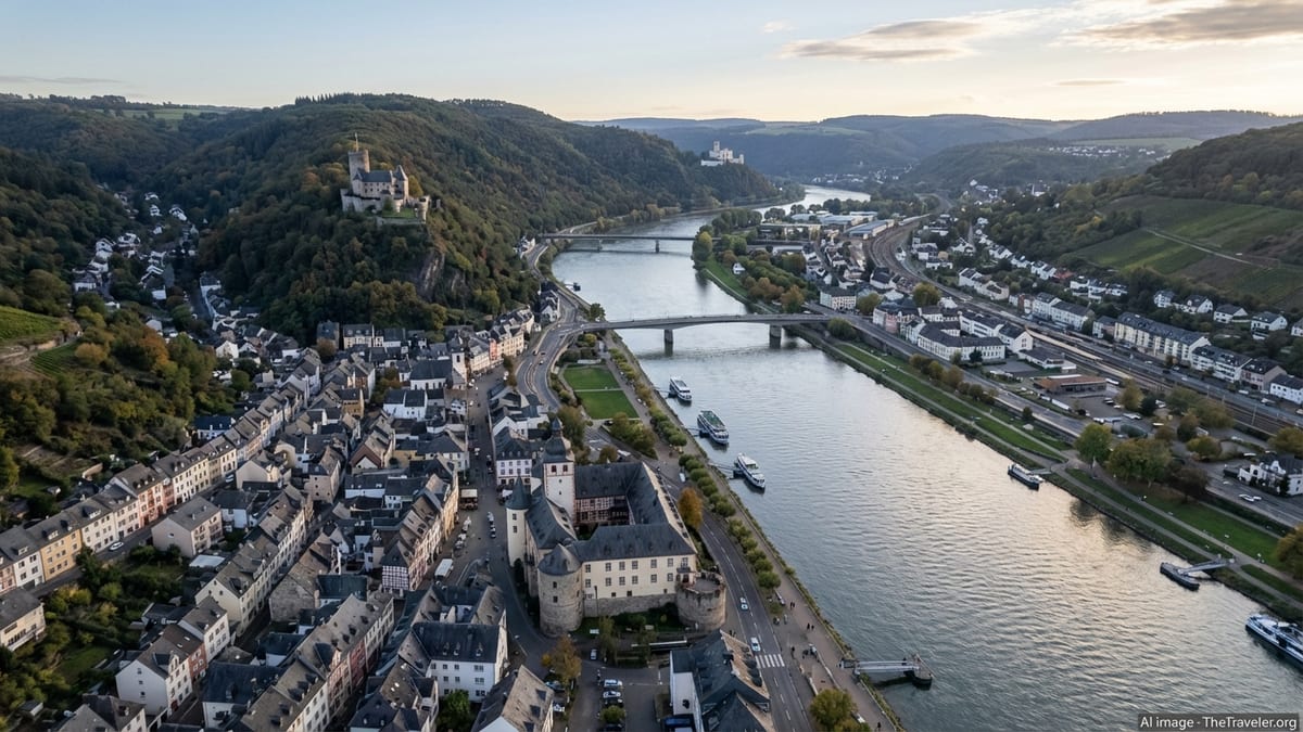
The Geography Behind the Town Plan
Lahnstein’s structure is dictated by water and rock. The Rhine flows broadly from south to north, a major traffic corridor since Roman times. Just south of Koblenz, the smaller Lahn River cuts in from the west, meeting the Rhine at a shallow angle. Lahnstein wraps around this confluence, with the lower-lying riverside quarters framed by steep hills that rise quickly toward forests, vineyards and the promontory of Burg Lahneck.
Administratively, Lahnstein consists of two main divisions. Oberlahnstein occupies the south bank of the Lahn at its junction with the Rhine and stretches up the hillside toward Lahneck Castle. Niederlahnstein sits on the north bank of the Lahn and the right bank of the Rhine, hugging the flatter ground between river and rail lines. Both were independent towns until 1969, and their street patterns still reflect separate histories and focal points rather than a single planned whole.
On the map, this produces a distinctive Y-shaped urban footprint. The stem of the Y is the Rhine corridor, with riverfront streets and promenades running roughly parallel to the current. One branch follows the Lahn inland toward Friedrichssegen, while another climbs upslope into residential areas and forest. Bridges tie these arms together at the Lahn, turning what were once separate riverfronts and marketplaces into linked districts.
As you move through town, you constantly cross these invisible lines: from the broad, linear space of the Rhine bank into the tighter, enclosed feeling of the old town streets; from the flat, rectilinear blocks of the newer quarters into the irregular, almost organic pattern of medieval lanes around the old town hall and town gates. It helps to set expectations when comparing Lahnstein vs Koblenz.
Oberlahnstein: Reading the Old Town on Foot
Oberlahnstein’s historic core is compact, immediately legible and best understood as a fan spreading inland from the Rhine. Its lower edge is marked by Schloss Martinsburg, the former customs castle and today a defining landmark on the waterfront. From here, narrow streets angle up toward the marketplace and the timbered Old Town Hall, roughly forming the middle of the fan. Farther uphill, the gradient steepens and the streets turn into short, terraced lanes and stairways guiding you toward Burg Lahneck above the town.
On a map, the medieval old town appears as a dense, slightly oval cluster. The marketplace with the Ancient Town Hall sits close to the center of that oval. Historic gates such as the Kihrstor mark the former openings in the city wall and act as natural entry points into the maze of lanes. Standing by the town fountain in front of the Old Town Hall, you are essentially at the heart of the former walled city, with streets radiating in several directions: toward the Rhine, toward the Lahn, and uphill toward the church of St. Martin and the fortress above.
The line of the former town wall still shapes the street grid. In places, the wall has been absorbed into later houses, but you notice curved or angular streets that follow its course. Squares are small and irregular rather than grand and symmetrical. This is a pedestrian-scaled core, designed long before motor traffic. Cars circulate mainly on the periphery, leaving the inner lanes often cobbled and quiet, with buildings crowding the pavement and sightlines terminating in slate roofs or church towers rather than distant vistas.
For visitors, that means orientation relies on vertical markers as much as on street names. The hexagonal tower of Martinsburg, the baroque turret of the Old Town Hall and the silhouette of Burg Lahneck above all serve as waypoints. Glance up and you can easily reset your mental map: castle above, Rhine below, marketplace in between.
Niederlahnstein: Riverfront Axis and Rail Corridor
Niederlahnstein lies across the Lahn on the right bank of both rivers, and its layout feels subtly different. Historically it was less tightly walled and more open to the surrounding landscape, and its modern structure reflects this. The old nucleus developed along the Rhine road, which today doubles as a federal highway and a busy transit corridor. Parallel to the river and set slightly inland, the railway line adds another strong linear element.
On a map you see Niederlahnstein as a band of development squeezed between water and tracks. Streets tend to run in long, straight segments parallel to the Rhine and Lahn, forming a grid that is simpler and more regular than the pattern in Oberlahnstein. At certain points, perpendicular streets link riverbank to station area, creating cross-axes that funnel both pedestrians and vehicles toward key nodes.
The most important of those nodes is Niederlahnstein station, which anchors the eastern side of the district. Here the right-bank Rhine railway intersects with the Lahntal line, and the streets around the station form a modest but distinct center with shops and services. If you arrive by train, your first impression of Lahnstein is often shaped by this transport-oriented environment, with the riverfront only a short walk away along straight, utilitarian streets.
The historic fabric, meanwhile, gathers closer to the rivers, particularly around the Romanesque Johanniskirche near the Rhine bank. Older houses and ecclesiastical buildings are clustered here, and side streets narrow slightly as they approach the water. Yet even in this area, the feeling is more open than in Oberlahnstein; river views, embankments and green strips give breathing space to the urban form.
Bridges, Crossings and How the Halves Connect
Understanding Lahnstein’s layout means paying attention to its bridges. For centuries, Oberlahnstein and Niederlahnstein were separated not just by political allegiance but by the physical barrier of the Lahn. Today multiple crossings knit the town together, and each has its own influence on the surrounding pattern of streets and riverfront paths.
The principal road bridge over the Lahn, part of the federal highway network, sits close to the confluence and connects the riverfronts of both districts. On the Oberlahnstein side, feeder streets from the old town and from the Rhine embankment merge into a compact set of junctions leading up to the bridge ramp. On the Niederlahnstein side, the bridge spills almost directly onto the main Rhine road, reinforcing the sense of a T-shaped intersection between highway, riverbank and cross-Lahn traffic.
Farther inland, additional bridges carry both road and rail across the Lahn. These are utilitarian structures, but on the map they create crucial loops that let traffic bypass the most historic, constrained areas of Oberlahnstein. For visitors, that means heavy through-traffic can often be kept to the periphery, leaving the central old town more walkable and less dominated by cars than the narrow medieval streets might suggest.
For pedestrians and cyclists, the crossings are equally important. From the station in Niederlahnstein, it is a short walk across the river to Oberlahnstein’s old town via bridge-connected sidewalks and paths. Once across, you can follow riverfront promenades back toward the Rhine, or angle up into the market quarter. This layered network of crossings and embankment paths encourages a circular way of exploring: across one bridge, along one river, back over another bridge and along the other bank.
The Riverfronts: Promenades, Parks and Working Quays
Along both Rhine and Lahn, the town’s layout softens into linear green spaces, quays and promenades that double as a kind of open-air map. Follow the water and you will almost always be led to something of interest. In Oberlahnstein, the riverfront at Schloss Martinsburg is especially illustrative: the castle sits just behind the quay, its walls almost touching the embankment, while moorings for Rhine boats and river cruise vessels extend along the shoreline.
Here, pedestrian paths wind between the road and the water, interspersed with small lawns, benches and landing stages. The promenade gives clear axial views up and down the Rhine, with Stolzenfels Castle on the opposite bank and Burg Lahneck above. In urban design terms, this river edge functions like a long terrace overlooking a stage. The town’s built fabric recedes a little, leaving a generous horizontal band where locals stroll, cyclists pass by and visitors wait for boats.
On the Niederlahnstein side, riverside spaces are a slightly more mixed picture of recreation and infrastructure. Walking along the Rhine bank, you encounter embankments with paths and grassy strips, but also sections where the railway and road come close to the water, compressing the available public space. The Lahn bank, especially closer to the confluence, offers quieter walking routes and occasional small harbors and boat facilities, reflecting the river’s role as a corridor for leisure craft as much as for commercial traffic.
Together, these riverfronts form a necklace that strings together the more tightly packed districts. For orientation, remember that the Rhine axis gives you a long, almost uninterrupted line from which the rest of the town branches off. Find the water, follow it until you see the outline of Martinsburg or the profile of Burg Lahneck above the trees, and you can quickly reorient yourself in physical as well as historical space.
Layers of History in the Street Pattern
The map of Lahnstein is not just a diagram of streets and rivers; it is a palimpsest of different eras. The medieval core of Oberlahnstein, with its city walls, marketplace and town hall, is the oldest clearly legible layer. Narrow, kinked lanes follow the logic of defense and topography more than any planning rubric. The town gates, such as the Kihrstor, appear slightly askew in relation to later streets, revealing their origin as controlled openings in a fortified ring.
Tracing a loop along the line of the former fortifications, you pass houses built directly onto remnants of the wall, where centuries of infill have blurred the original outlines. Around the market fountain and the Ancient Town Hall, plots are small and irregular, evidence of incremental growth and subdivision. Even in the 21st century, business signs, café terraces and bistros such as those facing the town hall adapt to this inherited geometry, rather than trying to impose a modern grid.
In Niederlahnstein, the historic layer is more ecclesiastical and river-oriented. The Romanesque Johanniskirche stands close to the Rhine, and surrounding streets show a quieter, almost village-like pattern: short side lanes, modest squares and paths that originally led fields and vineyards down toward the river. Industrialization and the arrival of the railway added another layer, one that is easy to see on the map as long linear tracks, sidings and station approaches cutting across the older fabric.
Post-war reconstruction and late 20th-century expansion add the most recent layer: housing estates on the outskirts, modern commercial strips along access roads and adjustments to accommodate bridges and federal highways. These newer zones tend to adopt broader curves, cul-de-sacs and standardized lot sizes, contrasting strongly with the tight medieval weave near the old town hall. Yet even here, topography still dictates where things can go. Hillsides and forested ridges set natural limits, keeping the overall footprint relatively compact.
How to Navigate: Mental Map for First-Time Visitors
Lahnstein is small enough that you rarely need a detailed street plan, but having a mental structure in mind will make your first hours in town more rewarding. Picture the Rhine as your north–south spine and the Lahn as a short arm stretching westward. Oberlahnstein sits on the southern side of that arm, with its old town climbing up to Lahneck Castle. Niederlahnstein occupies the northern, flatter side, framed by the rail line and station.
If you arrive by train, identify which station you are using. Niederlahnstein station places you on the right bank of the Rhine in the northern half of town. From there, the simplest route to the old town of Oberlahnstein involves walking toward the Lahn, crossing one of the bridges and then following signs or the natural flow of pedestrians toward the Ancient Town Hall and marketplace. Oberlahnstein station sits closer to the south-bank core, with Martinsburg and the old town reached via a short walk downhill and east toward the river.
Once within Oberlahnstein’s historic center, let landmarks guide you more than exact street names. To find the marketplace, head toward the sound of water and voices; it lies roughly between the main church and the Rhine embankment. To reach the riverfront, simply walk downhill until the buildings open out and you can see the broad band of the Rhine. To climb to Burg Lahneck, follow uphill streets and signposted paths, which eventually break out of the dense fabric into wooded slopes and castle approaches.
Niederlahnstein’s layout responds more to rational axes. The Rhine road runs parallel to the water, the rail corridor a short distance inland. Signage points toward the Johanniskirche and riverbank walks, and from almost anywhere in the district you are no more than a few minutes’ walk from either the water or a transport hub. The overall impression is of a town that invites both linear strolls along the river and short, purposeful crossings back and forth between its two historic halves.
The Takeaway
Seen on a flat sheet of paper, Lahnstein’s layout might appear straightforward: two riverfront neighborhoods, a handful of bridges, a castle on the hill. Experienced on the ground, it reveals itself as an intricate but surprisingly intuitive mesh of medieval lanes, 19th-century rail corridors and modern promenades, all stitched together by the twin lines of Rhine and Lahn.
Oberlahnstein offers the densest dose of history, its old town fanning gently up from Schloss Martinsburg and the river to the ramparts of Burg Lahneck. Niederlahnstein counterbalances this with a more open, linearly organized structure, knitted to the wider region by railway and highway, yet still anchored by its own church, quays and riverside paths. Between them, the bridges and embankments act as unifying elements, turning what were once separate settlements into a single, legible townscape.
For the traveler, understanding this structure is more than an exercise in cartography. It shapes how you move through Lahnstein, where you pause, how you orient yourself when stepping out of a station or off a riverboat. With a simple mental framework in mind, the town’s old streets and riverfront walks become easier to read, and what might have been a brief stop between larger Rhine destinations turns into a richly layered place to linger, explore and return to.
FAQ
Q1: Is Lahnstein one old town or two separate centers?
Lahnstein effectively has two historic centers. Oberlahnstein on the south side of the Lahn contains the denser medieval old town with the Ancient Town Hall and Martinsburg, while Niederlahnstein on the north side has its own older core along the Rhine but a more open, transport-oriented layout.
Q2: Where is the main old town area if I have limited time?
If you have to choose, focus on Oberlahnstein. The streets around the Ancient Town Hall, the marketplace, the Kihrstor gate and Schloss Martinsburg form the most atmospheric and compact old town quarter, all within easy walking distance of each other.
Q3: How do I get from the train station to the historic center?
From Niederlahnstein station, walk toward the Lahn River, cross one of the bridges and follow signs uphill and inland to the marketplace in Oberlahnstein. From Oberlahnstein station, it is a short walk downhill toward the Rhine and Martinsburg, after which a few minutes on foot brings you into the old town streets.
Q4: Is Lahnstein easy to explore on foot?
Yes. Distances between key sights are short, and much of the historic core in Oberlahnstein is pedestrian in character. Some streets are steep as you climb toward Burg Lahneck, but the riverfront promenades and old town lanes are generally manageable for most visitors.
Q5: How can I recognize the former city walls and gates?
In Oberlahnstein, look for features such as the Kihrstor, a preserved town gate, and for curved or angular streets that seem to encircle the old town. These often follow the line of the former walls, with houses and later buildings incorporating masonry from the original fortifications.
Q6: Where are the best riverfront areas for a walk?
The Rhine embankment near Schloss Martinsburg in Oberlahnstein offers one of the most scenic stretches, with views of Burg Lahneck and Stolzenfels Castle. On the Niederlahnstein side, sections along both Rhine and Lahn provide quieter paths, green strips and small harbors ideal for a leisurely stroll.
Q7: How is traffic routed so the old town is still pleasant?
Major through-traffic uses the federal roads along the Rhine and the bridges and bypasses farther from the medieval core. This leaves many of the narrow old town streets in Oberlahnstein calmer and more pedestrian-friendly, even though access by car is still possible on the periphery.
Q8: Is the town layout suitable for cycling?
Cyclists benefit from the relatively flat river corridors and from regional cycle routes that pass along the Rhine and Lahn. The old town streets can be cobbled and narrow, so cycling there requires care, but the overall structure makes it easy to combine town exploration with longer rides through the valley.
Q9: How do the hills and castle affect the town plan?
The steep slopes above Oberlahnstein and the promontory of Burg Lahneck limit expansion uphill, concentrating the old town on terraces between the water and the castle. Streets often follow the contour of the hillside or climb in short, stepped segments, which gives this part of Lahnstein its distinctive vertical emphasis.
Q10: Do I need a detailed map, or will basic orientation be enough?
For most visitors, a simple schematic map or digital overview is sufficient. If you remember that the Rhine is the north–south spine, the Lahn branches westward, Oberlahnstein’s old town lies on the southern bank beneath Lahneck Castle and Niederlahnstein stretches along the northern, rail-lined bank, you will find it easy to navigate by landmarks and riverfront paths alone.