
Circling Lake Michigan is one of the great classic road trips in North America, but there is no single “right” way to do it. Whether you are driving the full loop, hopping across on a fast ferry, or flying into a city and renting a car, the choices you make about how to get around will shape your experience along the shoreline. Understanding the main driving corridors, ferry links, and urban access points around the lake helps you build an itinerary that fits your time, budget, and comfort level.
Understanding the Shape of a Lake Michigan Trip
Lake Michigan is large enough that how you move around it becomes part of the adventure. The lake stretches past four U.S. states, and its shorelines range from dense urban skylines in Chicago and Milwaukee to dune country in western Michigan and quiet boreal forests in the Upper Peninsula. Distances can be longer than they look on a map, and travel times shift with summer traffic and lake-effect weather, so it pays to think in terms of corridors and segments rather than a single loop.
Many travelers approach Lake Michigan as a rough rectangle. The southern edge runs between Chicago and northern Indiana, the eastern side follows Michigan’s west coast, the northern edge crosses the Upper Peninsula and northern Wisconsin, and the western side drops south through Green Bay and Milwaukee back to Chicago. You can drive that outline entirely on land or “cut corners” with ferries that cross the lake between Wisconsin and Michigan. Each choice trades time against cost and experience.
If you are new to the region, it helps to decide early whether you want to prioritize scenic shoreline driving, efficient connections between cities, or a mix of both. The interstate system offers the fastest way between major hubs, while state highways and scenic byways pull you closer to the water and into the small towns that give a Lake Michigan trip its character.
Seasonality matters. Summer and early fall bring the most ferry sailings, road construction, and traffic. Spring and late fall are quieter but can mean cooler temperatures along the lake. Winter travel around Lake Michigan can be beautiful but demands flexibility because of snow, ice, and occasional road closures.
Driving the Classic Lake Michigan Circle Tour
The Lake Michigan Circle Tour is a signed route that roughly follows the lake’s perimeter on existing highways. It is not a single road but a patchwork of interstates, U.S. highways, and state routes, with green and white signs marking the way in each state. You can start anywhere, but Chicago, Milwaukee, and Grand Rapids are common gateways because of their air connections and rental car options.
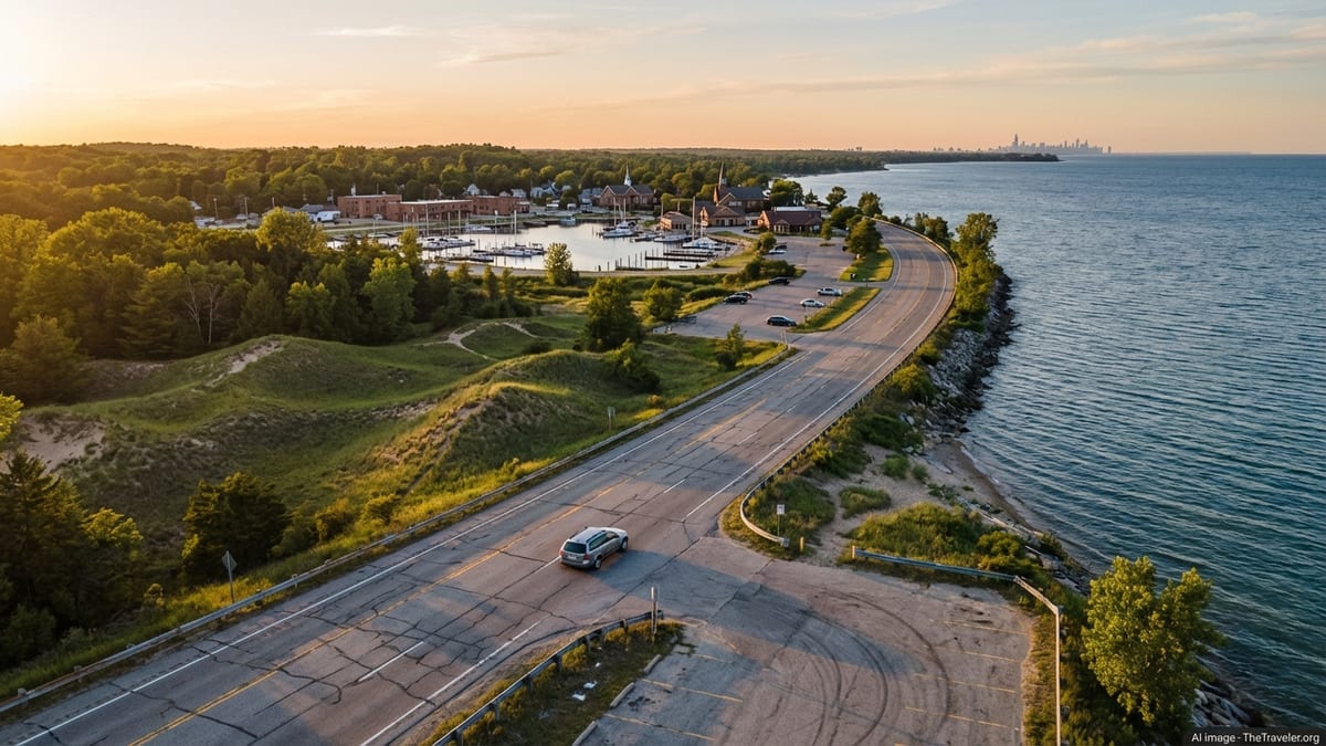
On the Michigan side, much of the Circle Tour overlaps with the West Michigan Pike Pure Michigan Byway, a historic lakeshore route that uses a combination of interstate and U.S. highways between New Buffalo near the Indiana state line and Ludington farther north. Portions follow Interstate 94, Interstate 196, and U.S. 31 while dipping into lakefront towns such as St. Joseph, South Haven, Holland, and Muskegon. This corridor balances efficient driving with frequent access to beaches, lighthouses, and dune parks, and it is one of the easiest stretches for first-time visitors to handle in a day-by-day format.
North of Ludington, the route becomes more rural as it heads toward the Sleeping Bear Dunes area and the Leelanau Peninsula. Short side drives, including Pierce Stocking Scenic Drive within Sleeping Bear Dunes National Lakeshore, offer sweeping overlooks of Lake Michigan and the dune formations. Farther north, the Circle Tour crosses the Straits of Mackinac on the Mackinac Bridge, then swings west through Michigan’s Upper Peninsula before re-entering Wisconsin and turning south toward Green Bay and Milwaukee.
Driving the full loop without long stops can take three to five long days, but most travelers spend at least a week and often more. For planning, think in segments of two to four hours of driving per day, leaving space for beach time, short hikes, and exploring small downtowns. The Circle Tour signage is useful, but you should still rely on up-to-date maps or navigation, since detours and construction are common in peak building seasons.
Fast Highways vs Scenic Lakeshore Roads
When you plan how to get around Lake Michigan by car, you will constantly choose between faster inland interstates and slower shoreline routes that hug the water. The fastest north-south spine on the western side is Interstate 94, which links Chicago to Milwaukee and continues toward Madison and the Twin Cities. Between Chicago and Milwaukee, the drive is straightforward and heavily traveled, with service areas, rest stops, and frequent exits, but views of the lake are limited.
On the eastern side of the lake, Interstate 94 and U.S. 31 handle much of the long-distance traffic through southwest Michigan, while Interstate 196 provides a direct connection between Benton Harbor, South Haven, and Holland. These roads sit a few miles inland in many places. To reach actual lakefront towns, you often exit onto state highways or local roads that lead to harbors and beaches. This pattern continues north, where U.S. 31 and state routes weave between agricultural inland areas and shoreline communities like Muskegon, Pentwater, and Manistee.
Scenic byways and county roads deliver the kind of slow travel many visitors are after: two-lane blacktop flanked by orchards, dunes, and glimpses of open water. They also add time. In summer, traffic jams can form near popular resort towns at check-in and check-out times, and parking near beaches may fill quickly on sunny weekends. If you have only a few days, it can make sense to use highways in the morning to leapfrog between regions, then slow down on local roads in the afternoon.
Consider your own driving comfort. Some backroads wind over dunes and through forests with limited shoulders. In fog, rain, or lake-effect snow, sightlines can shrink fast. If you are renting a car, a standard sedan is enough for most of the paved network. Travelers planning to camp or spend time on unpaved forest tracks may prefer a vehicle with higher clearance, but four-wheel drive is rarely necessary in summer on primary touring routes.
Cross-Lake Ferries: Lake Express and S.S. Badger
Two main car ferries connect the Wisconsin side of Lake Michigan to western Michigan, turning what would be a long highway swing around the southern end of the lake into a direct lake crossing. The faster option is the Lake Express, a modern high-speed ferry linking Milwaukee, Wisconsin, with Muskegon, Michigan. It typically operates from spring into fall, with a sailing time of about two and a half hours between the two cities. Terminals are located close to lakeside roads and have quick access to nearby highways, which makes the ferry appealing for travelers looking to bypass Chicago-area traffic while still keeping their vehicle with them.
The second major ferry is the S.S. Badger, a historic car ferry that runs between Manitowoc, Wisconsin, and Ludington, Michigan. Lake Michigan Carferry, the operator, publishes seasonal schedules that usually run from mid-May into October, with daytime crossings of around four hours and, in recent seasons, additional overnight sailings on selected dates. The ferry is recognized as part of a U.S. highway connection across the lake and can accommodate a mix of cars, recreational vehicles, motorcoaches, and commercial trucks. Current schedules note that the crossing links Eastern and Central time zones and that parking at the terminals is generally straightforward.
Neither ferry operates year-round, and sailings can be affected by strong winds, waves, or mechanical issues, so your plans should include some flexibility. Schedules and fares change from season to season. Recent figures show that foot-passenger and vehicle fares can add up quickly for families, particularly on the faster Lake Express, but the time saved and driving stress avoided often balance the cost for many travelers. The S.S. Badger tends to be somewhat slower but can be more economical for longer vehicles and offers a more leisurely onboard experience.
In practice, ferries can either form the centerpiece of a Lake Michigan itinerary or act as a one-way shortcut. Some travelers drive up the Wisconsin side, cross eastbound on the S.S. Badger or Lake Express, then return to Chicago through Michigan’s lakeshore towns, or reverse that sequence. If you intend to travel during peak summer weekends, reservations are strongly advised, particularly if you are traveling with an RV or trailer or if you are relying on an overnight sailing to shape your driving days.
Flying In: Accessing Chicago and Milwaukee
For many visitors, the most efficient way to start a Lake Michigan road trip is by flying into a major regional hub and renting a car at the airport. Chicago and Milwaukee are the two primary air gateways on the lake itself. Chicago offers two large airports, O’Hare International and Midway, with O’Hare handling the majority of long-haul and international flights. Milwaukee Mitchell International, a smaller but well-connected airport, sits south of downtown Milwaukee with direct freeway access to Interstate 94.
From O’Hare, you can reach downtown Chicago by public transit on the Chicago Transit Authority Blue Line, which offers 24-hour service between the airport and the Loop. Typical travel times into the central business district are on the order of 40 to 50 minutes, with more frequent trains in daytime hours. Taxis and rideshare services such as Uber and Lyft provide door-to-door connections that may take 25 to 45 minutes in light traffic and longer at peak times, with prices varying according to demand. Once downtown, many travelers pick up rental cars from in-city locations to avoid driving directly from the airport, especially if they plan to spend a day or two exploring Chicago before heading around the lake.
Midway Airport lies southwest of downtown Chicago and is connected by the Orange Line of the city’s rail system, as well as by taxis, rideshares, and airport shuttles. For road trips that swing through northwest Indiana and the Michigan lakeshore, Midway’s location on the south side can be convenient, since it avoids the need to cross the entire metro area after arrival. Travelers with evening flights should factor in heavy commuter traffic on weekday afternoons on the expressways that feed both airports.
Milwaukee Mitchell International sometimes offers a calmer alternative. The airport is linked to downtown Milwaukee and Chicago by Amtrak’s Hiawatha Service, a corridor train that runs multiple daily round trips between the two cities with a stop at the airport station. This means you can land in Milwaukee, take the train to Chicago or vice versa, then rent a car from either city, giving additional flexibility if airfares differ. As always, train schedules change, so it is important to check current departure times and reservation policies when planning connections.
Using Trains and Buses Between Lake Michigan Cities
While most travelers rely on cars to access smaller Lake Michigan communities, major cities around the lake are linked by a modest but useful network of trains and intercity buses. On the western shore, the Amtrak Hiawatha Service connects Chicago and Milwaukee with several daily departures, serving riders who want to move between the two cities without driving. The journey is comparatively short and can be an efficient way to start or end a road trip if you prefer to return a rental car in a different city.
South and east of Chicago, Amtrak services and regional buses run toward Indianapolis, Detroit, and Grand Rapids, creating additional gateways to the lake region beyond the immediate shoreline. For example, itineraries that start in Detroit or Grand Rapids often use rental cars for the final segment to the lakeshore, especially when visiting resort towns and state parks that lack direct rail connections. Intercity bus companies also link Chicago with smaller Michigan cities inland from the lake, but schedules and routes evolve frequently, so you should verify options close to travel dates.
Within the largest cities on the lake, local transit is practical for urban sightseeing without a car. Chicago’s rail and bus network covers the downtown and many neighborhoods, and Milwaukee’s buses now interface with a downtown streetcar system as well as regional bus routes. In Muskegon, Ludington, and Manitowoc, transit options are more limited, often focusing on local bus routes and seasonal shuttles. For travelers relying entirely on public transport, building a trip that centers on Chicago, Milwaukee, and perhaps one or two easily reached Michigan cities is usually more realistic than trying to visit multiple smaller beach towns without a car.
Even for drivers, understanding public transport options helps with parking and congestion. In Chicago, for instance, it is common to park near a suburban rail station or along the Blue Line and ride into the city core to avoid expressway traffic and expensive downtown parking. Similar park-and-ride strategies exist around Milwaukee’s commuter corridors and can make one-day visits simpler when you are in the midst of a longer Lake Michigan road trip.
Accessing Key Shoreline Regions by Car
Once you have reached the Lake Michigan basin, the next challenge is understanding the best approach roads into particular shoreline regions. For Chicago’s lakefront, expressways such as Interstate 90 and Lake Shore Drive funnel directly toward downtown and the Museum Campus, but traffic volumes can be intense. If your priority is the northern suburbs and beaches around Evanston and Highland Park, using U.S. 41 and associated parkways can be more pleasant, albeit slower at peak periods.
Reaching the southwest Michigan shoreline from Chicago or the Midwest interior typically involves heading east on Interstate 94 before branching onto local exits for towns like New Buffalo, St. Joseph, and South Haven. Many of these exits are well signed for “lakefront” or “beach” areas. As you move north toward Holland, Grand Haven, and Muskegon, U.S. 31 and Interstate 196 handle most of the traffic. These routes offer frequent access points to state parks and public beaches, though parking can require patience in midsummer. Planning arrival for earlier in the day often improves your chances of finding a spot close to the sand.
Further north, past Muskegon and Ludington, state highways and smaller roads lead into more remote stretches of dunes and forest. Approaches to Sleeping Bear Dunes National Lakeshore typically use U.S. 31 or M-72 to reach Glen Arbor, Empire, and surrounding communities, with side roads accessing scenic lookouts and trailheads. In the Upper Peninsula, U.S. 2 and U.S. 41 carry travelers along the northern arc of the lake and toward the Mackinac Bridge. On the Wisconsin side, U.S. 41 and Interstate 43 are the main spines south of Green Bay, with signed routes toward peninsula destinations such as Door County and the smaller ferry to Washington Island across Death’s Door strait.
In all of these regions, navigation apps work well, but cellular coverage can become patchy away from towns. It is sensible to download offline maps and to keep a general paper map or road atlas in the car, especially if you plan to drive at night or in shoulder seasons when services may close earlier in the evening.
Practical Tips for Timing, Weather, and Safety
Travel times around Lake Michigan can fluctuate with road construction, holiday weekends, and the kind of localized storms that build quickly over large bodies of water. Summer often brings lane closures on key highways, especially near cities, which can add significant delay at midday. Leaving early in the morning or later in the evening can smooth out driving days and reduce time spent in backups. For cross-lake ferries, operators will adjust or cancel sailings during high winds or rough seas, so flexibility in your schedule and an awareness of cancellation policies can prevent frustration.
Weather varies along the lake’s length. The southern shore near Chicago may be warm and sunny on days when fog lingers along the cooler waters farther north. In spring and fall, temperatures can drop quickly in the evening, making it important to keep layers in the car even if the day begins sunny. In winter, drivers should be ready for sudden snow squalls produced by lake-effect systems, particularly in the eastern and northern sectors. If you are unaccustomed to snow and ice, consider limiting winter driving to daylight hours and the main highways, which are plowed and salted more frequently than rural roads.
Basic road-trip precautions go a long way. Carry water, snacks, and a small emergency kit, and keep your fuel level comfortably above empty, especially along less developed stretches of shoreline and in the Upper Peninsula, where services can be spaced farther apart. Rest areas and state parks provide opportunities to stretch and regroup. If you will be renting a car, ask about roadside assistance coverage as part of your agreement so you know who to call if you experience a breakdown in a remote area.
Lake Michigan is a shared ecosystem and cultural landscape, so driving respectfully matters. Observe speed limits through small towns, watch for cyclists on popular scenic roads, and heed signage in tribal lands and protected areas. Many communities depend on summer visitors and work hard to balance tourism with quality of life for residents. Leaving extra time in your schedule makes it easier to drive calmly, stop frequently, and enjoy the trip rather than racing from point to point.
The Takeaway
Getting around Lake Michigan is less about a single road and more about a flexible framework of highways, ferries, and transit connections. You can swing quickly between major cities on interstates, linger on scenic byways beside dunes and orchards, or sail across the lake itself on classic car ferries. Each mode of travel offers a different perspective on the same body of water, and most trips end up mixing several approaches rather than relying on just one.
Start by deciding how much time you have and whether you want your route to be a complete loop, a cross-lake shortcut, or a series of day trips from a base city such as Chicago, Milwaukee, or Grand Rapids. Build your plan around realistic daily driving distances, seasonal ferry schedules, and a clear sense of how you will enter and exit the region by air or rail. Leave room for weather, construction, and those inevitable unplanned stops at a particularly inviting beach or roadside farm stand.
With a thoughtful approach to the basic logistics, the practical challenge of moving around Lake Michigan becomes simple, and the focus shifts toward the shorelines themselves: the changing light on the water, the rhythm of waves along the sand, and the succession of communities that ring the lake. In the end, the route you choose is as much a part of the experience as any single destination along the way.
FAQ
Q1. How long does it take to drive all the way around Lake Michigan?
Driving the full loop without major stops can be done in three to five long days, but most travelers allow at least a week to explore comfortably.
Q2. Is it better to drive or take a ferry across Lake Michigan?
Driving around the south end is usually cheaper, while ferries save time and avoid Chicago-area traffic. Many itineraries use both, driving one way and sailing the other.
Q3. Do the Lake Michigan car ferries operate year-round?
No. The Lake Express and S.S. Badger typically run from spring into fall. Exact season dates and daily schedules vary, so you should check current information before booking.
Q4. Can I do a Lake Michigan trip without renting a car?
You can move between major cities by train and bus and rely on local transit, but reaching smaller beach towns and parks is difficult without a car, especially outside summer.
Q5. Which airport is best for starting a Lake Michigan road trip?
Most visitors fly into Chicago O’Hare, Chicago Midway, or Milwaukee Mitchell. Choose based on flight options, price, and whether you plan to focus on the Michigan or Wisconsin side.
Q6. How far in advance should I book ferry tickets?
For peak summer weekends, booking several weeks ahead is sensible, especially if you are traveling with an RV, trailer, or need a specific sailing time.
Q7. What kind of vehicle do I need to drive around Lake Michigan?
A standard sedan is sufficient for the main highways and most scenic roads. Higher clearance is helpful only if you plan to explore unpaved forest tracks or backroads.
Q8. Are there toll roads around Lake Michigan?
Yes, portions of the interstate system near Chicago and northwest Indiana use tolls. You can pay as you go or use compatible electronic transponders where available.
Q9. Is winter driving around Lake Michigan safe?
It can be safe with preparation, but snow and ice are common. Stick to major highways, allow extra time, and consider limiting driving to daylight if you are inexperienced in winter conditions.
Q10. How much daily driving is realistic on a Lake Michigan road trip?
Many travelers aim for two to four hours of driving per day, leaving time for beach stops, meals, and exploring towns along the way.