
Stretching from the sandy Thumb of Michigan to the limestone cliffs of Ontario’s Bruce Peninsula, Lake Huron is less about marquee cities and more about stitched-together moments: a sunrise over an empty beach, a lighthouse at dusk, a quiet main street where the bakery still sells out of cinnamon buns by midmorning. A thoughtful Lake Huron travel route can combine both sides of the border, linking compact towns and expanses of protected nature into one continuous journey around one of North America’s great inland seas.
Understanding the Lake Huron Region
Lake Huron is the second largest of the Great Lakes by surface area, yet it often feels like the quiet cousin of Michigan and Superior. Look at a map and its shoreline appears lacy, broken by long peninsulas, wide bays, river mouths and more than a thousand islands. That complexity is what makes it so satisfying to explore: a road trip here naturally alternates between settled stretches of farm country, compact towns clinging to the water’s edge, and long reaches of forest, dunes and rock where human presence nearly disappears.
On the United States side, the coast runs north from Michigan’s Thumb through the Saginaw Bay region, then arcs along what tourism officials brand the Sunrise Coast, a roughly 200 mile corridor of US 23 between Tawas City and Alpena. This shoreline gives travelers sandy public beaches, low bluffs, and access to the Huron National Forest further inland, where signed scenic drives and quiet campgrounds pull you off the main highway. The further north you go, the more coniferous and remote the landscape becomes, with smaller harbors and fewer big-box conveniences.
Across the water in Ontario, the eastern shore presents a different feel. Highway 21 winds through a chain of cottage towns such as Grand Bend, Goderich, Kincardine and Southampton before angling inland toward Owen Sound. Here, nineteenth century lighthouses, historic main streets and long shallow beaches draw both local families and summer visitors. North of Owen Sound, Highway 6 carries you up the Bruce Peninsula, a narrowing spine of farms, alvar, and limestone cliffs that ends in the harbor village of Tobermory and the open expanse of northern Lake Huron and Georgian Bay.
The centerpiece of a combined towns and nature route is the connection between the Bruce Peninsula and Manitoulin Island by the Chi Cheemaun ferry. This seasonal car and passenger ferry has become a symbol of summer on this part of the lake, typically operating from early May into mid October and linking two very different landscapes in a two hour crossing. Build that link into your route and you can create a loop that feels both coherent and surprisingly varied, touching multiple regions while keeping daily driving stages manageable.
Designing a Cross-Border Lake Huron Loop
For travelers who want to combine towns and nature without backtracking excessively, a practical approach is to design a rough loop that uses Michigan’s US 23 Heritage Route and connected state highways on one side, and Ontario’s Highway 21 and Highway 6 on the other. Starting in the southern part of the lake keeps driving days short at first, which is useful if you are arriving from farther afield. It also lets you experience the gradual transition from agricultural landscapes into more rugged forest and rock as you move north.
One commonly used pattern begins in mid Michigan, perhaps near Bay City or Standish, then follows US 23 north along the Sunrise Coast toward Alpena. This segment is about taking your time between small towns: Tawas City, Oscoda, Harrisville and Alpena each offer lakefront parks, modest marinas and access to state or local beaches. Between them you can detour inland to the River Road National Scenic Byway or similar signed drives through the Huron National Forest, trading open water vistas for hardwood forest, river overlooks and wildlife viewing pullouts.
From the Alpena area, you can continue north and then west toward the Straits of Mackinac, crossing into the Upper Peninsula before dropping south along the northern shore of Lake Huron toward St Ignace and the Les Cheneaux Islands area, or turning inland toward Sault Ste. Marie if you want a city break. The more time you devote to this northern segment, the wilder the trip will feel, with long stretches of two lane highway, modest services and quiet lakeside campgrounds or motels. This is a good section to build in flexible days for hikes or paddling, since weather on the big lake can change quickly.
The Canadian side of the loop often starts with a border crossing at Sarnia or Port Huron, or farther north at Sault Ste. Marie if you are approaching from Michigan’s Upper Peninsula. You can drive south along the Ontario shoreline, or more commonly, join the loop by heading east from Sault Ste. Marie through the North Channel toward Espanola and the turnoff for Manitoulin Island. Road distances in this northern Ontario section are significant but lightly trafficked; services cluster in smaller towns, so topping up fuel and groceries becomes part of the rhythm of the day.
Michigan’s Sunrise Coast and Forested Interior
US 23 between Tawas City and Alpena is often promoted as Michigan’s Sunrise Coast, and for good reason. The road tracks close to the lake for long stretches, with frequent access points to public beaches, piers and lakeside parks. Early risers can catch the sun lifting over the horizon with only a few dog walkers for company, particularly outside peak weekends. Small resort communities dot this corridor, offering motels, independent lodges, and a growing number of short term rentals in converted cottages.
Plan time to leave the highway for side trips into the Huron National Forest, which actually lies a short distance inland rather than hugging the shoreline. Forest Service roads and signed scenic drives such as the River Road National Scenic Byway offer river overlooks, interpretive sites, and a different sense of scale than the open lake. Here you are traveling under closed canopy, with trailheads for hiking and mountain biking, and campgrounds set back from the water where the lake’s winds are replaced by the rustle of pines. These detours are especially welcome during hot, humid stretches along the shoreline.
Even on the busiest summer weekends, it is usually possible to find quieter corners. State parks and recreation areas tend to fill first, while lesser known county parks or road end beaches may see a trickle of visitors rather than crowds. Local visitor centers along US 23 keep updated brochures and maps that can point you toward smaller natural areas, inland lakes and birding sites. This section of the lake is also popular with anglers, so you will notice a steady presence of small fishing boats and marinas that cater to them.
Because US 23 runs roughly parallel to Interstate 75 farther inland, it is straightforward to modify your route day by day. If weather on the lake is poor, you can cut inland on connecting roads, spend a night in a larger inland town with more dining options, then return to the shore the next day. That flexibility makes the Sunrise Coast a forgiving place to start or end a Lake Huron itinerary, especially for those new to Great Lakes travel or driving long distances.
Harbors, Lighthouses and Cottage Towns in Ontario
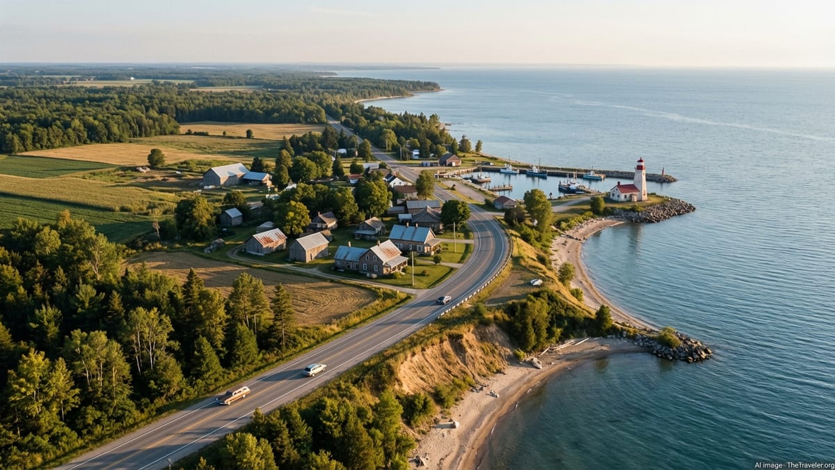
Crossing to Ontario, the mood shifts from long open shorelines to a patchwork of farm fields, small river mouths and compact harbor towns backed by modest escarpments. Highway 21 is the spine of this eastern Lake Huron route, connecting communities that have long histories as ports and agricultural service centers. Towns such as Goderich, Kincardine and Southampton still show their nineteenth century roots in the layout of their downtowns and their lighthouses, many of which remain active aids to navigation while also serving as visitor attractions.
Goderich, often described in tourism materials as one of Ontario’s prettiest towns, sits on bluffs above a deepwater harbor. Its octagonal town square, historic streetscapes and terraced parks down to the lake make it a pleasant overnight stop, with local inns and small hotels within walking distance of the waterfront. Further north, Kincardine and Point Clark offer long beaches, lakefront parks and access to another of the lake’s notable lighthouses, an Imperial Tower built in the mid nineteenth century that still stands watch above the shoreline.
As you continue toward Saugeen Shores, Port Elgin and Southampton offer a mix of marina life and wide sandy beaches fronted by multi use trails and boardwalks. These are friendly family oriented resort areas in summer, with ice cream stands, lakeside playgrounds and evening promenades to watch the sunset over Lake Huron. During shoulder seasons, the same waterfronts are quieter, with more space for long walks, photography and birdwatching as migrating waterfowl move along the flyway.
From Southampton, Highway 21 bends inland toward Owen Sound, where you can resupply in a small city that has grown up around a natural harbor at the head of Georgian Bay. Alternatively, travelers focused on Lake Huron’s towns and nature often head straight north from Southampton up Highway 6 to Wiarton, Lion’s Head and Tobermory. That route climbs onto the limestone spine of the Bruce Peninsula, with its characteristic mix of rural fields, cedar edged backroads and increasingly dramatic cliffs and coves on the Georgian Bay side.
Bruce Peninsula, Manitoulin Island and the Chi Cheemaun
The Bruce Peninsula is one of the most striking landscapes on the Lake Huron circuit, and a natural hinge point in any route that combines towns and wildshore. As you approach Tobermory at the peninsula’s northern tip, the land narrows and the water reasserts itself on both sides. The town itself is compact, with a sheltered harbor, working charter docks and a modest cluster of accommodations and restaurants. It also serves as a gateway to national parklands on both the Lake Huron and Georgian Bay sides, where marked trails lead to viewpoints over turquoise coves, sea caves and sheer cliffs.
Tobermory is also the southern terminal for the Chi Cheemaun, the seasonal car and passenger ferry linking the Bruce Peninsula to South Baymouth on Manitoulin Island. The operator typically runs a spring schedule beginning in early May, an expanded high season timetable with multiple daily sailings from mid June through early September, and a reduced fall schedule into mid or late October, with parking fees at the terminals charged during the sailing season. Because the ferry is popular with both tourists and local residents, advance reservations for vehicles are strongly recommended in peak periods, especially on weekends and around holiday Mondays in Canada.
The crossing itself takes about two hours and serves as a welcome break from driving. On board, passengers can move between enclosed lounges and open decks, watching as the cliffs and coves of the Bruce recede behind and the low, forested profile of Manitoulin grows ahead. Service has evolved to include seasonal cultural programming that highlights Indigenous art and storytelling, reflecting the deep First Nations presence in the region. For many travelers, the sailing becomes one of the most memorable elements of the route, precisely because it slows the pace of the trip and centers the lake rather than the road.
On arrival at South Baymouth, you step into a different landscape again. Manitoulin Island, often described as the world’s largest freshwater island, has a distinct rhythm of small communities, quiet inland lakes and low, forested hills. Roads from South Baymouth connect north toward Mindemoya and west toward larger centers such as Little Current and Gore Bay. You can treat Manitoulin as a one or two night transit stage, or as a destination in its own right, building in time for hiking, visiting lookouts, or simply exploring side roads that end at gravel beaches and small coves.
Practical Planning for a Lake Huron Route
Because Lake Huron’s shoreline is long and sparsely populated in places, thoughtful planning makes the difference between a relaxed journey and one that feels rushed. Start by deciding how many days you can devote to the route and whether you want to focus on one side of the lake or combine both Michigan and Ontario. Many travelers find that a week to ten days allows them to sample the Sunrise Coast, a portion of northern Michigan’s shore, Manitoulin Island, the Bruce Peninsula and a stretch of Ontario’s cottage coast without excessive daily driving. Shorter trips benefit from focusing tightly on one or two regions rather than trying to circle half the lake.
Accommodation choices range from lakeside campgrounds and basic motels to small inns and resort style properties in the more established town centers. Peak summer weekends and major holidays are busy on both sides of the border, particularly in hubs such as Tawas City, Alpena, Tobermory and the Saugeen Shores communities. If you are traveling in July or August, advance bookings for at least your key anchor nights are advisable, especially if you require family sized rooms or pet friendly options. Shoulder seasons may offer more spontaneity, though some smaller businesses reduce hours or close entirely outside the core months.
Ferry logistics deserve special attention. The Chi Cheemaun typically opens its reservation system several weeks or months ahead of the sailing season, and its schedule for the year, including dates, departure times and parking information at Tobermory and South Baymouth, is published by the operating company. Check those details before you lock in accommodations on either side of the crossing. Vehicle spaces can sell out on favored sailings, and schedules can be adjusted for maintenance or weather, so it is wise to build a buffer of time into your itinerary rather than planning for tight same day connections far down the road.
Border crossing points such as Sarnia–Port Huron or Sault Ste. Marie can add uncertainty to your timing. Traffic volumes fluctuate with holidays, commercial traffic and construction. Carry valid identification and any required travel documents, allow extra time on days when you must cross an international bridge, and remember that mobile coverage and data roaming charges may change as you switch countries. Many travelers keep a paper map or downloaded offline mapping as backup, particularly when exploring rural backroads or forest routes where signals can be unreliable.
Seasonality, Weather and Responsible Travel
Lake Huron’s moods change dramatically with the seasons, and your experience of the route will shift accordingly. Summer offers the most reliable conditions for swimming and beach life, along with the longest daylight hours and the full range of seasonal services. This is also when campgrounds, ferries and shoreline towns are busiest. Spring and autumn can be especially appealing for travelers focused on hiking, photography and quiet drives, though water temperatures remain cool and some tourism businesses run limited hours or close after Thanksgiving in Canada or Columbus Day in the United States.
Weather on and around the lake can change quickly at any time of year. Summer thunderstorms can roll in with little warning, while late autumn and winter bring lake effect snow squalls that can significantly reduce visibility and close portions of exposed highways in Ontario and Michigan. Check local forecasts daily, pay attention to advisories affecting routes such as Ontario’s Highway 21 or US 23, and be prepared to adjust your plans if conditions deteriorate. In shoulder seasons, carrying extra layers, rain gear and basic emergency supplies in the vehicle is prudent.
Wildlife is another constant on the Lake Huron route. Deer are common along rural roads, particularly at dawn and dusk, and smaller animals can appear suddenly from ditches or forest edges. Driving at moderate speeds on secondary roads and being especially alert at night reduces the risk of collisions. On the water, anyone paddling or boating should respect offshore winds and stay within their skill level, as conditions on the open lake can become rough quickly even on seemingly mild days.
Finally, a route that combines towns and nature invites a thoughtful approach to the places you pass through. Staying on marked trails in dunes and cliff top parks protects fragile vegetation and reduces erosion. Supporting locally owned accommodations, restaurants and outfitters keeps tourism revenue circulating in the communities that anchor the shoreline. Learning a bit about the Indigenous histories connected to places like Manitoulin Island and the Bruce Peninsula adds depth to the road miles, reminding you that these landscapes have been lived in and traveled for far longer than today’s scenic drives and ferry timetables.
The Takeaway
Traveling around Lake Huron is less about racing to a finish line and more about stringing together a sequence of lakefront towns, forest byways, island crossings and cliff edge walks into a route that feels personal. The combination of Michigan’s Sunrise Coast, the northern reaches of the lake, Manitoulin Island and Ontario’s cottage and lighthouse towns offers an appealing balance of small scale urban comforts and easy access to wildshore. With a bit of advance planning for ferries, border crossings and accommodations, it is possible to design an itinerary that feels spacious rather than rushed.
What makes this lake distinctive as a travel destination is its sense of scale combined with approachability. You can sit on a quiet beach at dawn or watch the sunset from a harbor breakwall and feel the big water stretching to the horizon, yet within minutes be back on a main street where the coffee shop owner recognizes regulars by name. That interplay of immense freshwater and close knit communities is at the heart of any rewarding Lake Huron travel route, and it is what draws many visitors back to explore one more town, one more side road, one more curve of shoreline.
FAQ
Q1. How many days do I need for a Lake Huron road trip that includes both Michigan and Ontario?
Most travelers find that seven to ten days allows a comfortable loop that includes sections of Michigan’s Sunrise Coast, the northern shore, Manitoulin Island, the Bruce Peninsula and a stretch of Ontario’s cottage coast, without excessively long driving days.
Q2. When does the Chi Cheemaun ferry between Tobermory and South Baymouth usually operate?
The Chi Cheemaun typically runs seasonally from early May to about mid or late October, with more frequent daily sailings in the peak summer period; exact dates and times vary by year, so always check the current schedule before you travel.
Q3. Do I need to book the Chi Cheemaun ferry in advance if I have a car?
Advance reservations are strongly recommended for vehicles during the main season, especially on weekends and around Canadian holiday Mondays, because popular sailings can sell out and same day space is not guaranteed.
Q4. What is the best time of year to drive the Lake Huron route?
Late spring through early autumn offers the most favorable conditions, with July and August providing warmest beach weather and full services, while May, June, September and early October often bring fewer crowds and cooler but comfortable temperatures.
Q5. Can I complete a Lake Huron loop without camping?
Yes, it is entirely possible to rely on motels, small hotels and inns in the towns along the route, though in quieter stretches it is wise to book ahead as choices can be limited outside peak resort areas.
Q6. Are there any border requirements I should plan for on a cross‑border route?
Travelers crossing between the United States and Canada must carry valid identification, such as a passport or approved equivalent, and should allow extra time at bridges like Sarnia–Port Huron or Sault Ste. Marie where traffic and inspections can cause delays.
Q7. Is the Lake Huron shoreline suitable for families with children?
Yes, many Lake Huron towns feature shallow sandy beaches, playgrounds and family oriented parks, though parents should always supervise children closely near the water because conditions on the lake can change quickly and there are often no lifeguards.
Q8. How difficult is driving on rural roads around Lake Huron?
Most routes use paved two lane highways that are straightforward to drive, but they can be narrow, curving and frequented by wildlife, so cautious speeds and extra attention at dawn, dusk and night are sensible.
Q9. Will I have reliable mobile coverage along the route?
Coverage is generally good near larger towns and along major highways, but there are patches of weak or no signal in forested or more remote areas, so downloading maps for offline use and carrying paper backups is advisable.
Q10. How can I travel responsibly in Lake Huron’s natural areas?
Staying on marked trails, packing out litter, respecting posted closures, supporting local and Indigenous owned businesses where possible, and minimizing disturbance to wildlife all help protect the shoreline and communities that make the Lake Huron route special.