
More news on this day
New York City has issued a hazardous travel advisory as forecasters warn that a fast-moving line of severe thunderstorms, heavy rain and strong winds could bring dangerous conditions to streets, bridges and public transit corridors.
Get the latest news straight to your inbox!
Storm System Poised to Disrupt Monday Travel
Weather outlooks for the New York metropolitan area indicate that a vigorous storm system is moving along the East Coast, with forecasters highlighting the risk of severe thunderstorms and localized flooding during peak travel hours. Short-range forecasts show a high probability of thunderstorms over the city and surrounding suburbs, with intense downpours possible in a relatively short period of time.
The National Weather Service has outlined scenarios in which damaging wind gusts and torrential rain could quickly reduce visibility and lead to ponding on highways and major arterials. The severe weather threat is expected to ramp up as the atmosphere destabilizes through the afternoon and early evening, coinciding with the commuter rush.
Regional coverage from weather outlets notes that much of the Northeast faces unsettled conditions as the storm tracks northeastward, interacting with warm and humid air already in place over the city. Even in areas that avoid the most intense cells, periods of heavy rain and gusty winds may still create challenging driving and walking conditions.
Forecast discussions also point to the possibility of rapid changes in conditions, with storms developing and intensifying over a matter of minutes. Travelers are being advised to plan for delays and build extra time into their journeys as the worst of the weather passes through.
City Urges Caution on Roads, Bridges and Transit
New York City emergency and transportation agencies have issued guidance urging residents and visitors to take the hazardous travel advisory seriously, particularly during the afternoon and evening period when impacts are expected to be most pronounced. Publicly available information emphasizes that even routine trips across the city could take significantly longer once bands of heavy rain arrive.
On the roads, the combination of slick pavement, ponding and reduced visibility raises the risk of spinouts and minor collisions, especially where drainage is poor or construction is ongoing. Low-lying parkways and underpasses around the city are often vulnerable during intense storms, with water accumulating quickly before crews can respond.
Bridges and elevated highways may also feel the effects of strong crosswinds as the line of storms passes. Transportation notices typically encourage drivers of high-profile vehicles to exercise additional caution and, when possible, delay nonessential trips until conditions improve.
For those relying on public transit, heavy rain and lightning can slow subway operations and commuter rail service, while surface routes may be hampered by street flooding and traffic congestion. Previous storms have demonstrated that even brief outages or signal issues can cascade into broader delays across the system when severe weather strikes during peak periods.
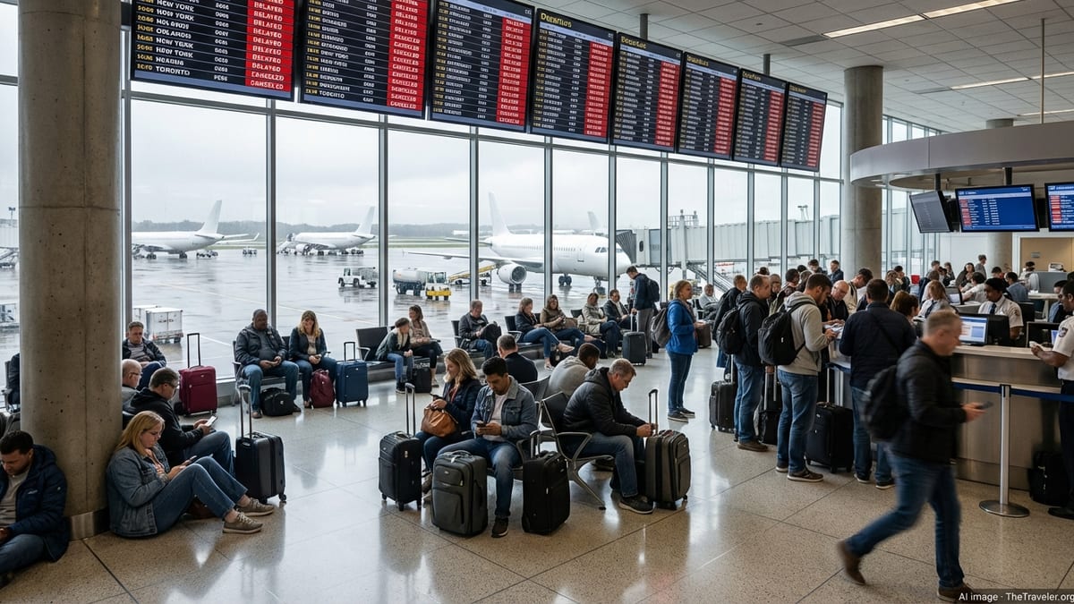
Air Travel and Regional Mobility Face Weather Headaches
The hazardous travel advisory extends beyond city streets to regional air and rail hubs, where severe weather frequently triggers ripple effects across the Northeast corridor. Thunderstorms near major airports can force ground stops, slow arrivals and departures, and cause airlines to reshuffle schedules to keep crews and equipment in position.
Recent storms across the country have already prompted travel waivers from major carriers when severe conditions were forecast for key hubs, allowing passengers to adjust itineraries without change fees. A similar pattern is possible in the New York area if thunderstorms linger near the region’s airports, where even temporary runway closures can lead to rolling delays.
Intercity rail operators routinely prepare for severe weather by adjusting equipment moves and monitoring low-lying track segments that are prone to flooding. Heavy downpours can result in speed restrictions or detours, stretching travel times for passengers moving through New York on dense regional routes.
Travel analysts note that summer thunderstorms often create some of the most complex operational challenges, because they can repeatedly redevelop over the same corridor. For travelers transiting through New York City, that means staying attuned to shifting departure boards and allowing for possible missed connections or extended layovers.
Residents and Visitors Encouraged to Prepare and Stay Informed
With the advisory in effect, city agencies and meteorologists are encouraging anyone in New York to prepare for rapid changes in conditions and to stay informed as the forecast evolves. Public guidance stresses the importance of monitoring local weather forecasts, transit alerts and citywide notification systems throughout the day.
Travelers are being encouraged to shift nonessential trips to earlier or later windows, use public transit where practical, and avoid driving through flooded roadways. Pedestrians and cyclists are urged to watch for deep puddles, slick metal surfaces and falling branches in tree-lined neighborhoods and parks.
Residents are also advised to secure loose outdoor items, check building gutters and drains where possible, and move vehicles away from flood-prone curbs or basement garages. Those with flights, long-distance train tickets or intercity bus reservations are being urged to check their status frequently and sign up for carrier-specific alerts in case of cancellations or schedule changes.
While the severity and exact timing of storms can vary from block to block, forecasters agree that the ingredients are in place for a disruptive period of severe weather. The advisory aims to give New Yorkers and visitors enough lead time to adjust plans, reduce exposure to the most hazardous conditions and keep the city’s already busy transportation network moving as safely as possible.