
More news on this day
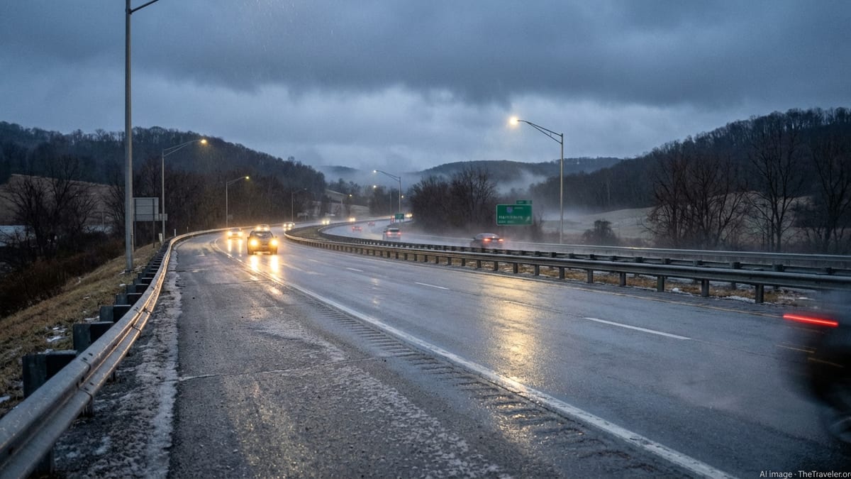
Central and western Pennsylvania commuters are being urged to brace for potentially slick roads late Monday night into early Tuesday, as a fast-moving system threatens to coat key corridors around Pittsburgh, Harrisburg and State College with a thin but hazardous layer of ice.
Overnight Glaze a Big Worry for the Tuesday Rush
Forecasters expect a surge of moisture to ride over a shallow dome of cold air across the Mid Atlantic and interior Northeast from late Monday, March 2, into the early hours of Tuesday, March 3. That classic setup for freezing rain could leave untreated roads, sidewalks and elevated surfaces dangerously slick just as many residents head out for work and school.
In central Pennsylvania, including the Harrisburg area, meteorologists are calling for a predawn period of freezing rain before temperatures slowly climb above freezing by late morning. Even a light glaze can be enough to cause spinouts and fender benders, particularly on bridges, overpasses and secondary roads that cool more quickly than heavily traveled interstates.
Across western Pennsylvania, including the Pittsburgh metro, a cold rain is expected to develop late Monday night into Tuesday. Local television forecasts indicate that locations north and east of the city, especially in higher elevations, have the greatest risk of seeing a brief window of freezing rain early Tuesday before readings edge upward. Drivers who commute into Pittsburgh from the ridges and outlying counties are being advised to allow extra time and monitor temperatures closely.
Farther north in the interior Northeast, national outlets are highlighting a broader swath of ice and wintry mix from the mountains of Virginia through central Pennsylvania and into New England on Tuesday. While accumulations look light, the timing around the morning commute has transportation officials on alert.
Travel Corridors and Airports Prepare for Slick Conditions
The threat may be modest in terms of total ice accumulation, but the geography of central and western Pennsylvania makes even minor icing a serious travel concern. Key east west and north south routes, including segments of Interstate 76, Interstate 80 and Interstate 99 near State College, traverse ridges and valleys where temperatures can vary by several degrees over short distances.
Transportation crews across the region spent the weekend tracking the evolving forecast and preparing to pretreat roadways where possible. With air temperatures expected to sit near the freezing mark around daybreak Tuesday, PennDOT has been emphasizing that black ice may not be visible to drivers until it is too late. Motorists are being urged to reduce speeds, increase following distance and take particular care on ramps and secondary routes.
Air travel could also feel ripple effects from the icy start to Tuesday. While major hubs such as Pittsburgh International typically see temperatures rise above freezing fairly quickly, even a brief window of freezing rain can trigger deicing operations, slowdowns in ground handling and minor delays that compound across the morning schedule. Regional jets that serve smaller central Pennsylvania airports are especially sensitive to changing runway conditions.
Rail and intercity bus operators are likewise monitoring the system. Any ice accumulation on platforms, steps and parking areas can create hazards for passengers, even if main travel lanes remain mostly wet.
Local Impacts: From City Streets to College Campuses
In Harrisburg and surrounding communities along the Susquehanna River, the main concern is a light coating of ice that arrives before sunrise Tuesday. With schools and state offices resuming regular schedules after the weekend, administrators will be watching early observations for any need to delay start times. Side streets and hillier neighborhoods, which often lag behind main arteries in treatment, will be particularly vulnerable to slick patches.
For Pittsburgh, the risk is more nuanced, with valley locations closer to the three rivers likely to warm marginally faster than outlying hills. Local meteorologists note that the difference between a cold rain and light icing in the northern and eastern suburbs could be a matter of just a degree or two. That uncertainty is driving calls for caution, especially for early shift workers and those traveling before sunrise.
In and around State College, where students and staff at Penn State are returning from weekend activities, the combination of untreated sidewalks, campus walkways and lightly traveled rural roads could pose a problem if temperatures hold near freezing as precipitation arrives. University officials often rely on short range forecasts and real time conditions to decide whether to alter bus routes or encourage remote work for early classes.
Residents across the region are being reminded to watch for icy steps, porches and parking lots. Even when primary roads appear merely wet, colder concrete and shaded areas can retain a film of ice into mid morning, increasing the risk of slips and falls for pedestrians.
From Wintry Mix to Remarkable Warmup by Late Week
The overnight ice threat comes at an odd moment in the seasonal transition. Meteorological spring began on Sunday, March 1, but the atmosphere is delivering another taste of winter before flipping rapidly to much milder conditions later this week. Forecasts from local stations and national outlets alike show a pronounced warmup developing over the eastern United States by Thursday and Friday.
In Pittsburgh, temperatures are expected to climb from the low 40s on Monday to near 70 degrees by the end of the workweek, accompanied by periods of rain and the potential for a few thunderstorms. Central Pennsylvania, including Harrisburg and State College, is likely to see a similar surge into the 60s or higher, turning any lingering snow piles into slush and runoff.
This roller coaster pattern, with quick swings from icy mornings to almost springlike afternoons, has been a hallmark of late winter across the region. Forecasters note that such variability can lull travelers into complacency, particularly when temperatures rebound quickly after a marginal freezing rain event. Drivers are being urged not to let the promise of warmth later in the week overshadow the more immediate hazards of Tuesday morning.
Hydrologists will also be keeping an eye on smaller streams and urban drainage systems if heavy rain follows the warmup. Although current projections do not point to widespread flooding, rapid snowmelt combined with additional precipitation can cause localized water issues where storm drains are clogged or ice remains.
What Commuters Can Do Before Heading Out
Emergency managers across central and western Pennsylvania are emphasizing preparation and flexibility as the best defenses against Tuesday morning’s ice risk. Travelers are encouraged to check multiple reliable weather sources on Monday evening, paying close attention to any updated advisories or changes in expected timing for freezing rain.
Before going to bed Monday night, residents can take simple steps such as moving vehicles off steep driveways, applying salt or traction material to steps and walkways, and staging ice scrapers and windshield washer fluid. For those who must be on the road early, allowing extra time in the morning can reduce the temptation to rush on potentially slick pavement.
Public agencies are also urging employers to consider flexible start times where possible, particularly for workers who commute from higher elevations or rural townships into urban centers. Past events have shown that even a small shift in the peak of the rush hour can lessen congestion and lower the risk of multi vehicle incidents when ice is present.
While the overnight icing threat does not appear severe enough for widespread power outages, scattered slick spots could still disrupt daily routines across Harrisburg, Pittsburgh and State College. For travelers and residents alike, a cautious approach to the Tuesday morning commute may be the key to getting through this brief return to winter unscathed, before springlike warmth quickly takes hold later in the week.