
More news on this day
A powerful low pressure system bringing intense rain, thunderstorms and damaging winds is sweeping across the United Arab Emirates, Oman and parts of southern Iran this week, disrupting transport links and raising fresh concerns for travelers moving through one of the world’s busiest aviation and transit hubs.
Get the latest news straight to your inbox!
Storm System Intensifies Over the Eastern Arabian Peninsula
Weather bulletins and satellite analyses indicate that a deepening low pressure system drawing moisture from the Arabian Sea and the Gulf of Oman is driving the latest spell of severe weather across the eastern Arabian Peninsula. Forecasters describe a complex pattern of converging air masses that is producing slow moving storm cells capable of delivering intense downpours in a short period of time.
Across northern Oman, including Muscat and the Al Batinah coast, heavy rain since the weekend has already triggered flash flooding in wadis and low lying districts. Published local reports describe vehicles swept away, road closures and rising casualty figures linked to rapidly rising water in normally dry channels. The same system is feeding moisture north and west toward the UAE and eastward toward the Iranian coast.
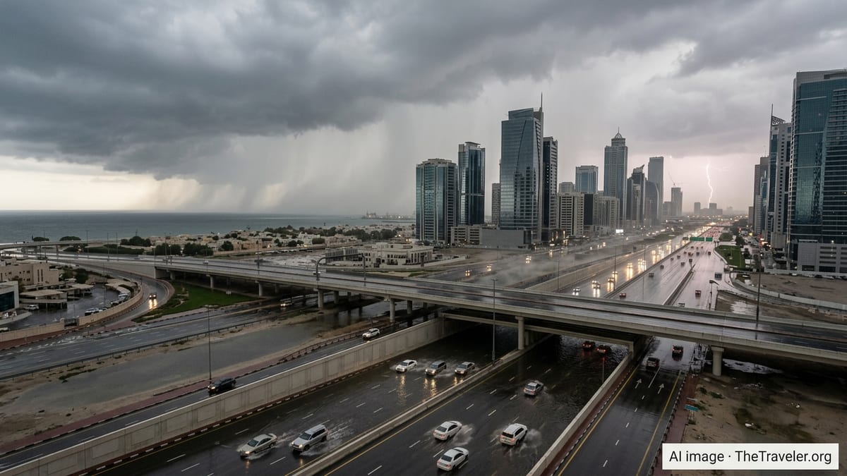
In the UAE, residents and visitors have reported repeated bursts of heavy rain, frequent lightning and squally winds since the start of the week, with online monitoring tools showing at least two distinct rain bands approaching from both the Arabian Gulf and the Oman coast. Social media commentary suggests that some neighborhoods have already seen levels of rainfall more typical of an entire season compressed into several days.
Along Iran’s southern shoreline, from Bushehr to the Strait of Hormuz, regional weather outlooks flag unstable conditions with periods of heavy showers and strong gusts as the system tracks eastward. While rainfall totals there appear more uneven so far, the combination of saturated ground in some districts and strong onshore winds is adding to concerns about local flash floods and hazardous driving conditions.
Air, Road and Sea Travel Face Growing Disruptions
The powerful storm is hitting at a time when Gulf airspace and transport corridors are already under strain from broader regional tensions. Travel advisories issued earlier this month highlighted partial airspace closures and significant rerouting of commercial flights over parts of the Middle East, contributing to delays and extended journey times for passengers transiting through major hubs.
Within the UAE and Oman, publicly available flight tracking and airline statements show weather related disruptions layered on top of those geopolitical constraints. Some services have experienced delays or diversions as aircraft are routed around the most intense storm cells, and as ground operations slow during bursts of torrential rain and lightning. Travelers report longer than usual waits at airports and occasional last minute changes to departure gates and times.
On the roads, the impact has been more immediate. Images and eyewitness accounts shared on social platforms from Muscat, Sohar and Barka in Oman, as well as from parts of Dubai and other emirates, show vehicles navigating deep standing water, reduced visibility in heavy rain and pockets of gridlocked traffic where underpasses and roundabouts have flooded. Police and traffic agencies in the region routinely warn that entering wadis or ignoring barriers during severe storms is both dangerous and a serious traffic offense.
Maritime movements in the Gulf of Oman and the approaches to the Strait of Hormuz are also affected. Port circulars and shipping advisories note rough seas, powerful crosswinds and intermittent reductions in visibility, prompting some operators to adjust schedules or temporarily suspend smaller vessel movements until conditions improve. For a region that handles a significant share of global energy exports and container traffic, even short lived disruptions can ripple out through supply chains.
Heightened Risks for Visitors in Urban and Desert Environments
For visitors, the main hazards from the current storm system stem from the sheer intensity of rainfall over short periods, which can overwhelm drainage systems in cities designed for arid conditions. In Dubai, Abu Dhabi and other UAE cities, as well as in Muscat and coastal Oman, road flooding can develop rapidly when storm drains back up, turning familiar routes into temporary lagoons and underpasses into deep water traps.
In desert and mountain areas, risks are even more pronounced. Dry riverbeds, or wadis, that appear safe under clear skies can become torrents when storms strike upstream, sending walls of water and debris rushing through canyons and road crossings with little warning. Regional disaster records show that many flood related casualties in recent years have occurred in vehicles caught in these sudden surges or in off road areas where escape routes are limited.
Strong, gusty winds accompanying the storms raise additional safety concerns, particularly around coastal promenades, construction zones and open desert highways. Blowing sand can sharply reduce visibility, and unsecured objects or temporary structures may become projectiles. On high rise balconies and rooftop terraces common in Gulf cities, loose furniture and equipment can pose risks to people at street level during sudden squalls.
The storm also intersects with the region’s heavy reliance on air conditioning and high rise living. Local commentators note that power interruptions, while generally brief, can be disruptive in densely populated areas if substations or transformers are affected by flooding. Residents and hotel guests in low lying neighborhoods have reported minor water seepage into basements, parking garages and ground floor units where drainage is inadequate.
Practical Safety Guidance for Tourists and Transit Passengers
Travel specialists and regional advisories emphasize that most trips through the UAE, Oman and southern Iran can continue with careful planning, but they urge visitors to adapt quickly to the changing conditions. The most consistent recommendation is to monitor official weather bulletins and airport or airline updates several times a day, rather than relying solely on long range forecasts that may not capture the precise timing or location of intense cells.
Visitors are advised to build extra time into all transfers, especially when connecting between flights or traveling to and from airports during active storm periods. Taxis, ride hailing services and hotel shuttles may need to take longer, safer routes to avoid flooded roads, and public transport services can experience delays if sections of track or bus corridors are affected by water or debris.
Safety guidance for road travel in the region consistently stresses avoiding wadis, underpasses and low lying shortcuts during and immediately after heavy rain. Drivers unfamiliar with local conditions are encouraged to follow major, well lit arterial roads where drainage and emergency response capabilities are stronger. Renting vehicles with good ground clearance and functioning wipers and headlights, and avoiding night driving during the worst of the weather, can significantly reduce risks.
Pedestrians and outdoor sightseers are also urged to adjust plans. Coastal walks, mountain hikes and desert excursions may need to be postponed if thunderstorms are in the forecast, while indoor attractions such as museums, malls and cultural centers provide safer alternatives. Tour operators often reschedule or cancel excursions during active weather alerts, and travelers are encouraged to check refund and rebooking policies in advance.
What to Watch in the Coming Days
Meteorological outlooks suggest that the storm system is likely to remain influential over the eastern Arabian Peninsula for several more days, though the exact placement of the heaviest rain and strongest winds will shift as the low pressure center evolves. Short range models hint at the possibility of renewed intense storms, including isolated rotating cells, over portions of the UAE and northern Oman as upper level winds interact with warm, moisture laden air at the surface.
In Oman, already saturated catchments in the Al Batinah and Muscat regions heighten concerns about additional flash flooding if new rounds of heavy rain develop. Urban drainage networks will take time to clear accumulated water and debris, and local authorities may keep certain roads or wadis closed as a precaution even during temporary lulls in the weather.
For Iran’s southern provinces, any eastward or northward wobble in the storm track could bring more sustained rain bands ashore, compounding localized flooding risks and potentially affecting smaller regional airports and ports. Given the concurrent geopolitical tensions and previous disruptions to airspace and shipping lanes, observers note that even weather driven interruptions can carry broader logistical implications.
For travelers, the coming days will require flexible itineraries, close attention to rapidly updated information and a willingness to postpone nonessential movements when conditions deteriorate. While the region’s infrastructure and emergency services are accustomed to handling bursts of extreme weather, the current combination of powerful rain and wind, complex storm dynamics and existing transport pressures makes prudent, weather aware decision making more important than ever.