
Storm Chandra has battered the United Kingdom with torrential rain, fierce winds and heavy hill snow, triggering record January rainfall in parts of the southwest, sparking major flood incidents and causing widespread travel disruption across road, rail, sea and air.
With amber "danger to life" warnings in force and saturated ground after a series of earlier storms, communities from Cornwall to County Durham have been left counting the cost and bracing for further weather systems later this week.
More News
- Five-Day Belgium Rail Strike Disrupts European Winter Travel and International Train Links
- Sheffield–Manchester Airport Trains Face Short-Term Disruption but Promise Smoother Journeys Ahead
- Delta, United, American Escalate Premium Arms Race. But Who’s Winning?
How Storm Chandra Formed And Where It Hit Hardest
Storm Chandra was officially named by the Met Office on Monday 26 January 2026 as a deep Atlantic low-pressure system intensified and moved toward the British Isles. Forecasters warned that its interaction with already saturated ground and pockets of colder air would create a cocktail of hazards: intense rainfall, gale force winds, coastal flooding and heavy snow over higher ground in the north. Amber warnings for rain were issued for south Devon, Dorset, southern Somerset and southeast Cornwall, while an amber warning for wind covered eastern Northern Ireland.
By the early hours of Tuesday 27 January, the system had swept across southwest England and south Wales before tracking north and east over the Irish Sea and into Northern Ireland and Scotland. Parts of Dartmoor recorded more than 100 millimetres of rain in 24 hours, close to or surpassing the average total for the entire month of January in southwest England. Rivers that had been running high since earlier storms responded quickly, with the River Otter in Devon and low-lying catchments in Somerset among those reaching or exceeding previous flood levels.
In Northern Ireland, gusts widely reached 60 to 70 miles per hour within the amber wind warning area, with coastal locations seeing higher peaks. These unusually strong easterly and southeasterly winds toppled trees, damaged buildings and created dangerous crosswinds on major routes and bridges. Further north, as the system encountered colder air over upland areas of northern England and Scotland, rain turned to snow. Upland routes across the Pennines, southern Scotland and the Highlands reported accumulations approaching 20 centimetres, leading to treacherous driving conditions and isolated communities.
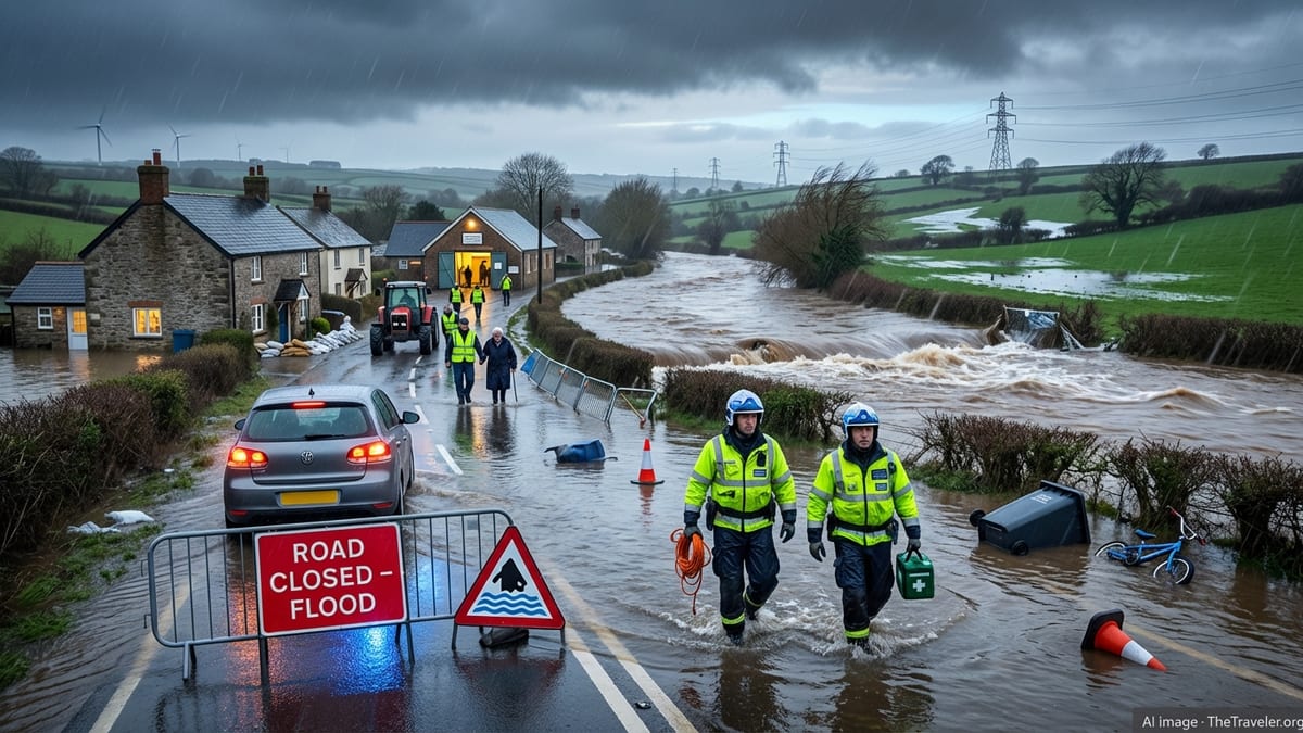
Record Floods And A Major Incident In Somerset
The most dramatic flooding impacts were felt across parts of Devon, Dorset and Somerset, where a perfect alignment of intense rainfall, saturated soils and constrained river channels left towns and villages rapidly inundated. In Ottery St Mary on the River Otter, a severe flood warning was issued with authorities warning that deep, fast-flowing water posed a danger to life. Residents in the most at-risk streets were urged to move family members, pets and cars to higher ground where safe to do so, and to switch off gas, electricity and water supplies.
In Somerset, the cumulative effect of overnight rain on already waterlogged fields prompted local authorities to declare a major incident on Tuesday. An estimated 50 properties were reported flooded across areas including Ilminster, Taunton, Mudford, West Coker and West Camel. The low-lying Somerset Levels, long vulnerable to prolonged wet spells and tidal surges, again found themselves under acute pressure as water drained from higher ground into an already burdened network of rivers, drains and pumping stations.
Flood warnings and alerts were issued on an exceptional scale. In England alone, there were close to 100 flood warnings, signifying that flooding was expected, alongside nearly 200 flood alerts indicating that flooding was possible. South-west England bore the brunt, but flood alerts were also in place for parts of Wales and Scotland as rivers rose and surface water pooled on urban roads and rural lanes. Local leaders in some of the hardest hit communities renewed long-standing calls for sustained investment in flood defences and maintenance, arguing that repeated inundation was becoming intolerable for residents and businesses.
Amber Warnings Explained: What “Danger To Life” Really Means
The sight of orange-shaded regions on Met Office maps and phrases such as “danger to life” can feel abstract until a storm like Chandra arrives. In the UK weather warning system, amber alerts signify an increased likelihood of severe weather impacts, where there is a real possibility of damage to property, disruption to travel, and a risk to life and safety. For Storm Chandra, amber warnings were focused on southwestern England for rain and on eastern Northern Ireland for high winds, reflecting the areas expected to see the worst combinations of intensity and duration.
In practice, an amber rain warning in south Devon, Dorset, southern Somerset and southeast Cornwall translated into 30 to 50 millimetres of rainfall widely, with 60 to 80 millimetres possible over higher ground such as south Dartmoor. Crucially, this deluge fell onto ground already saturated by a notably wet winter and previous named storms earlier in January. Under these conditions, even normally manageable rainfall totals rapidly translate into flash flooding, rising rivers and landslips.
The amber wind warning over eastern Northern Ireland highlighted the unusual direction and strength of the gusts. Easterly winds in the region are less common and can expose areas that are typically sheltered from Atlantic storms. Gusts of 60 to 70 miles per hour, and locally up to 75 miles per hour along exposed coasts, were strong enough to down trees, damage roofs, generate powerful waves and create hazardous conditions on ferries and bridges. Authorities urged people to reconsider travel plans, secure loose objects and stay away from coastal promenades during the peak of the storm.
Road, Rail And Air Travel Thrown Into Chaos
As predicted, travel networks bore the brunt of Storm Chandra’s onslaught. On the strategic road network, standing water rendered sections of the A30 in Devon impassable between Ottery St Mary and Exeter Airport, forcing the closure of a key east-west artery and long diversions for local and long-distance traffic. The A303 between Upottery in Devon and Horton Cross in Somerset was also closed due to flooding, compounding delays for drivers heading between the southwest and the rest of England.
In Dorset, sections of the A35 were shut in both directions near Dorchester, as floodwaters encroached on carriageways and debris washed into the road. Local police forces across Devon, Cornwall and Somerset reported “significant surface water and areas of flooding,” warning residents to avoid non-essential travel, particularly in and around Exeter, East Devon and Mid Devon. Motorist breakdown services reiterated their advice never to drive through standing water unless absolutely certain it is shallow and safe, pointing to vehicles stranded in unexpectedly deep floods.
Major bridges also faced restrictions. The M48 Severn Bridge between England and Wales closed to all traffic for a period at the height of the winds, with vehicles diverted to the newer M4 Prince of Wales Bridge. The Humber Bridge in northeast England barred high-sided vehicles because of crosswinds, leading to delays and re-routing for freight and long-distance bus services. Further north, the A66 across the Pennines between County Durham and Cumbria closed due to heavy snow, as ploughs and gritters struggled to stay ahead of drifting conditions.
Rail passengers were not spared. Flooded tracks, fallen trees and landslips affected multiple lines in southwest England, forcing cancellations and speed restrictions. Operators in the region warned that knock-on disruption could last beyond the immediate passage of the storm as engineers inspected embankments, cleared debris and checked signalling equipment. In Northern Ireland and Scotland, strong winds and ice led to further service alterations, while some rural bus routes were suspended purely on safety grounds.
Communities, Schools And Emergency Services Under Strain
Behind the stark numbers on rainfall totals and wind speeds lie the lived experiences of residents, commuters and local responders. Across the UK and Ireland, hundreds of schools closed as Chandra arrived, either due to direct flood impacts, hazardous journeys for staff and pupils, or power outages. In Northern Ireland alone, almost 250 schools were reported shut on Tuesday as a precaution, while several universities shifted to online teaching to keep people off the roads during the worst of the weather.
Emergency services and local councils mounted a round-the-clock response. Fire and rescue crews carried out dozens of vehicle rescues from floodwater in Devon and Somerset, as drivers found themselves unexpectedly trapped by rapidly rising water on rural lanes and underpasses. In some cases, boats were deployed to reach stranded residents in single-storey properties or caravans. Authorities repeatedly stressed that even apparently shallow floodwater can conceal hazards such as lifted manhole covers, strong currents or sudden drops.
Volunteer organisations also stepped in. The British Red Cross placed crisis response teams on standby in regions at greatest risk, coordinating with local resilience forums and councils. In communities already hit hard by earlier storms, volunteers carried out welfare checks on vulnerable residents, delivering items such as blankets, torches and battery-powered radios to those experiencing power cuts or cut off by fallen trees. Local community centers and village halls opened as rest centers for residents forced to evacuate or unable to return home overnight.
For many households, Storm Chandra has come as yet another blow in what has been a relentless winter of severe weather, with Storms Goretti and Ingrid already leaving a trail of damage across parts of the UK this month. Insurance claims are expected to rise sharply, particularly in southwest England and parts of Northern Ireland, as homeowners and businesses assess flood damage, roof failures and loss of stock or trade days.
What Travelers Need To Know Over The Coming Days
Although the core of Storm Chandra has now moved away from the UK, the aftermath is set to linger. River levels typically respond to heavy rain with a lag of several hours or even days, meaning that some catchments will continue to rise even as skies brighten. Forecasters warn that saturated ground leaves the region highly sensitive to further rainfall, and additional yellow rain warnings have already been issued for parts of southwest England later in the week, raising the risk of renewed disruptions.
For travelers, the key message is to plan carefully, check for updates, and be prepared to adapt. Motorists should consult live traffic information and heed local signage, especially in southwest England, South Wales, Northern Ireland and upland routes in northern England and Scotland, where snow and ice remain a threat. It is advisable to allow extra time for journeys, carry warm clothing and basic emergency supplies in vehicles, and avoid rural backroads that are prone to flooding or blocked by fallen trees.
Rail passengers should check with operators before leaving home, as some lines may remain closed for inspection or repair, particularly in flood-hit corridors. Replacement buses can be in short supply when multiple routes are affected at once, and weather-related disruption can invalidate normal expectations of compensation or onward connections. Airlines and ferry operators are likewise urging passengers to monitor communications closely, as residual high winds and swell may continue to affect schedules on exposed routes around the Irish Sea and English Channel.
Visitors from overseas, including those from the United States planning winter city breaks or countryside tours, are advised to stay informed through national broadcasters and official forecast providers. While major cities such as London, Birmingham and Edinburgh have largely escaped the worst flooding, onward trips into the countryside, coastal walks and self-drive itineraries may be affected. Travel insurance with comprehensive disruption cover remains particularly valuable in such a volatile season.
Storm Chandra In The Context Of A Turbulent Winter
Storm Chandra is the latest in a string of major weather systems to test the UK’s infrastructure and resilience this winter. Storm Goretti earlier in January brought hurricane-force gusts to parts of Cornwall and the Isles of Scilly, along with heavy snow across the Midlands and Wales that left tens of thousands without power and forced hundreds of school closures. Some of the communities now grappling with Chandra’s floods were still repairing damage from those earlier events.
Meteorologists point to a combination of atmospheric patterns, including a strong jet stream and conducive sea surface temperature anomalies in the North Atlantic, which have favoured repeated deep low-pressure systems tracking toward northwest Europe. While individual storms cannot be directly attributed to climate change, scientists note that a warming atmosphere can hold more moisture, potentially increasing the intensity of heavy rainfall events and exacerbating flood risk in already exposed regions.
Policy debates are intensifying around how the UK should adapt. Floodplain development, agricultural drainage practices, the maintenance of rivers and pumping infrastructure, and the role of nature-based solutions such as wetland restoration all feature in discussions about reducing future risk. For travelers and tourism-dependent businesses, there is growing recognition that winter weather volatility may become a more frequent operational challenge, demanding better contingency planning and clear communication with guests.
FAQ
Q1: Where has Storm Chandra hit the hardest in the UK?
Southwest England has seen some of the most severe impacts, particularly parts of Devon, Cornwall, Dorset and Somerset, where intense rainfall on saturated ground has led to significant river and surface water flooding. Eastern Northern Ireland has experienced very strong winds, while higher ground in northern England and Scotland has been affected by disruptive snowfall.
Q2: What do the amber weather warnings for Storm Chandra actually mean?
An amber warning indicates that severe weather is more likely to have significant impacts, including a risk to life, property damage, travel disruption and power cuts. For Chandra, amber warnings for rain and wind signalled that authorities expected dangerous conditions, urging people to reconsider travel plans and take extra safety precautions.
Q3: How has Storm Chandra affected travel in the UK?
The storm has caused major disruption across road, rail and air networks. Key routes such as sections of the A30, A303 and A35 in southwest England have been closed by flooding, while bridges like the M48 Severn Bridge have faced closures or restrictions. Rail services in affected regions have seen cancellations and delays due to flooded tracks, fallen trees and debris.
Q4: Is it safe to travel to or within the UK right now?
Most of the UK remains accessible, but conditions vary by region and can change quickly. Travel is generally possible with careful planning, but anyone heading to southwest England, parts of Wales, Northern Ireland or upland areas in the north should check the latest forecasts and transport updates, allow extra journey time and avoid driving through floodwater.
Q5: What should I do if my travel plans go through a flood-affected area?
If your route passes through an area under flood warnings, consider rerouting to main roads on higher ground or adjusting your travel time. Always follow official diversion signs, heed road closures and never attempt to drive through standing water of unknown depth. For rail or air travel, stay in close contact with your operator about rebooking or alternative options.
Q6: Are airports and flights being cancelled because of Storm Chandra?
Some regional airports and routes have experienced delays and cancellations, mainly due to high winds, reduced visibility or staff and passengers being unable to reach terminals. The situation differs from one airport to another, so it is essential to check directly with your airline before setting out and to allow more time for check-in and security.
Q7: How long will flooding and disruption from Storm Chandra last?
While the worst of the rain and wind has passed in many areas, river levels can continue to rise for 24 to 48 hours or more after heavy rainfall. Some roads, rail lines and properties may remain affected for several days as water recedes and repairs are carried out. Additional rain later in the week could slow recovery in the most saturated catchments.
Q8: What precautions should I take if I am driving during or after the storm?
Plan your route on main roads where possible, check for closures, and avoid traveling at night in rural or flood-prone areas. Reduce your speed in heavy rain, be wary of aquaplaning and never drive through floodwater unless you are absolutely sure it is shallow and safe. Carry warm clothing, a fully charged phone, food, water and basic emergency supplies in case you become stranded.
Q9: How are local communities and emergency services coping?
Emergency services, councils and volunteers are working continuously to respond to incidents, rescue trapped motorists, support evacuations and provide welfare checks for vulnerable residents. Many communities were well prepared due to early warnings, but repeated storms this winter have stretched resources and heightened concerns about long-term resilience and mental strain on residents.
Q10: Could more storms like Chandra affect UK travel later this winter?
Forecasters cannot specify exact future storms, but current patterns suggest the potential for further unsettled, stormy spells during the remainder of winter. Travelers planning trips to the UK over the coming weeks should keep an eye on long-range forecasts, build flexibility into their itineraries where possible and ensure their travel insurance covers weather-related disruption.