
More news on this day
Texas is once again on edge as a new round of severe storms and tornado watches sweeps across the state today, threatening to upend already fragile spring travel plans from San Angelo to Houston and Dallas Fort Worth.
Fresh Tornado Watches Add to a Turbulent March
Weather forecasters warn that a volatile mix of warm, moist Gulf air and an approaching cold front is setting the stage for another dangerous evening across central and west central Texas. The National Weather Service has issued multiple tornado watches through late tonight, including for communities around San Angelo and portions of the Hill Country, where forecasters say conditions are favorable for rotating supercell thunderstorms capable of producing tornadoes, large hail and damaging winds.
National outlets and local meteorologists report that Texas is part of a broader multi-state corridor under threat, with millions facing the possibility of severe weather from the Southern Plains into the Midwest. The agency’s Storm Prediction Center has placed cities such as San Angelo, Abilene, Wichita Falls and Kerrville under an enhanced risk level for severe storms, a designation that typically signals scattered intense storms and a few strong tornadoes are possible.
The renewed threat comes less than a week after a deadly and disruptive early March tornado outbreak across the central United States that included several confirmed tornadoes in Texas. Communities that only just cleared debris and restored power are now watching radar again, mindful that the peak of the state’s severe weather season is only beginning.
Travel planners say the clustering of events so early in the season is a warning sign for the weeks ahead, particularly for those transiting through Texas on spring break trips or cross-country road journeys.
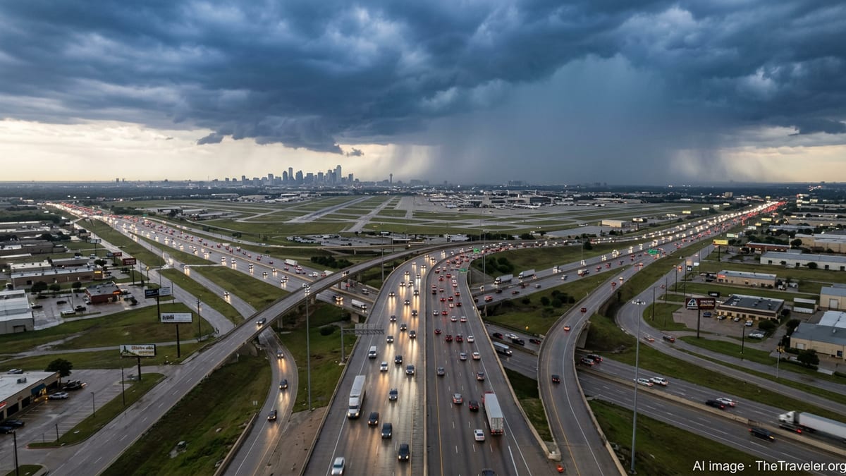
Airports in North and Southeast Texas Brace for New Disruptions
Texas airports are entering tonight’s storms with little margin after a bruising start to March. Over the weekend, Dallas Fort Worth International Airport imposed a temporary ground stop as strong thunderstorms moved through North Texas, leading to hundreds of delays and leaving travelers stranded in long rebooking lines. Aviation tracking sites and travel industry analysts noted that DFW, one of the world’s busiest hubs, remains highly sensitive to convective storms, with even brief halts triggering cascading delays across the national network.
Today, Houston’s George Bush Intercontinental Airport and DFW are again among the nation’s most closely watched hubs as the severe weather zone shifts. Industry reports indicate that both airports ranked among the hardest hit in the United States for cancellations and delays earlier in the day as the larger storm system swept across multiple states. Airlines are preemptively trimming some schedules and issuing weather waivers, allowing passengers to change flights without fees as they track the evolving tornado threat.
Federal Aviation Administration advisories suggest that additional ground stops or flow controls remain possible into the evening if thunderstorms with strong rotation approach major terminals or flight corridors. Low clouds, lightning and sudden wind shifts pose additional risks, forcing air traffic managers to slow arrivals and departures even in areas not under a direct tornado warning.
For international and long-haul passengers connecting through Texas, the combination of weather-related delays and full spring flights means missed connections can quickly turn into overnight stays. Travel experts are urging flyers bound for or transiting via DFW, Dallas Love Field, Houston Bush Intercontinental, Houston Hobby, Austin Bergstrom and San Antonio to monitor flight status closely and prepare for schedule changes on short notice.
Highways, Buses and Trains Confront Rapidly Changing Conditions
On the ground, the looming storms pose equally serious challenges. The Texas Department of Transportation has been using social media and roadside message boards in recent days to remind drivers that tornado-producing storms can form and intensify quickly along busy interstate corridors, particularly I 10, I 20, I 35 and I 45. Heavy rain, hail and sudden crosswinds can reduce visibility and make high profile vehicles such as buses and trucks especially vulnerable.
Motor coach companies serving popular routes between Dallas, Austin, San Antonio and Houston are monitoring radar closely and warning passengers of potential delays, diversions or temporary suspensions if warnings are issued along scheduled paths. Some regional carriers say they will hold buses at depots rather than depart if forecasters indicate imminent tornadic activity or hail large enough to damage windshields.
Rail operators are also on alert. Freight and passenger trains crossing the plains of West and Central Texas may be slowed or temporarily halted as dispatchers respond to severe weather warnings, reports of downed power lines or debris near tracks. Even when storms pass quickly, crews must visually inspect lines and bridges before normal speeds can safely resume, extending delays well beyond the period of active weather.
Travel organizations advise motorists to avoid driving through warned areas after dark, when fast moving storms and flooded low water crossings can be harder to spot. Travelers already on the road are being urged to identify sturdy shelter options along their route in advance, such as interior rooms of well built buildings, in case a tornado warning is issued.
Systemic Vulnerabilities Exposed by a String of Severe Events
The current tornado watches are exposing longstanding vulnerabilities in how Texas handles weather driven transportation shocks. Despite periodic upgrades to radar networks, emergency communications and airport infrastructure, the state’s combination of sprawling cities, rapidly growing exurbs and critical interstate corridors means there are few easy workarounds when storms close skies and roads simultaneously.
Recent nationwide statistics from the first week of March show thousands of flights canceled and more than five thousand delayed in a single day as severe storms and winter weather swept across multiple hubs, including Dallas Fort Worth. Analysts say that Texas, with its heavy reliance on a handful of major airports and intercity highway corridors, is particularly exposed to such compound events when tornado threats overlay already strained systems.
Experts in emergency management point out that while tornadoes are localized compared with hurricanes or blizzards, the unpredictability of where and when they touch down makes it difficult for airlines, bus operators and railroads to position crews and equipment optimally. A single long track tornado or swath of giant hail can temporarily close a regional airport, sever a key highway, or damage a critical rail junction, rippling through networks far from the immediate damage path.
The early March severe weather pattern, which has already produced confirmed tornadoes in Texas and neighboring states, is reinforcing calls for more robust contingency planning, including greater use of flexible ticketing policies, backup bus and rail capacity, and better real time data sharing between meteorologists, transport agencies and private operators.
What Travelers Should Expect in the Coming Days
With the atmosphere primed for more severe weather across the Southern Plains, travel forecasters expect intermittent disruptions to continue through midweek. While not every storm will produce tornadoes, the overlapping threats of large hail, damaging straight line winds and flash flooding will keep risk levels elevated for anyone moving through central, north and west Texas.
Air travelers can expect rolling waves of delays, especially during late afternoon and evening hours when daytime heating fuels the strongest storms. Short haul flights within Texas and to nearby states are most likely to be canceled or rescheduled because airlines can more easily consolidate passengers and crews, but long haul journeys may also face missed connections or significant arrival delays as aircraft and staff end up out of position.
Road trippers and commercial drivers are being encouraged to build extra time into itineraries, avoid tight same day commitments and maintain multiple alternate routes. Authorities remind travelers never to attempt to outrun a tornado in a vehicle and to treat low water crossings with caution in the event of flash flooding, which often accompanies severe spring storms in Texas.
For those set to travel through the Lone Star State over the next several days, the message from forecasters and transport officials is clear: remain flexible, stay informed through trusted weather and traffic updates, and be prepared for sudden changes, as Texas again walks a fine line between routine spring storms and travel chaos.