
Trier is a rare European city where a paper map or smartphone screen still feels like a time machine. Within a compact area, the outlines of a Roman imperial capital, a medieval market town, and a modern riverside city all overlap. Understanding how these layers fit together on the ground is the key to making the most of your visit.
Seeing landmarks on a map makes the things to do in Trier easier to plan. This guide presents a mental “Trier map,” oriented around three anchors: the Roman monuments, the atmospheric old town, and the Moselle riverfront.
Getting Oriented: How Trier Fits Together
Trier sits in a curve of the Moselle River in western Germany, close to Luxembourg. The river forms the city’s western and southern edge, while the historic core lies slightly inland on a gentle rise. Most of what visitors come to see lies inside or just beyond the footprint of the Roman city, which still shapes the modern street plan. Once you see how the main landmarks relate to one another, navigating Trier becomes intuitive.
Think of Porta Nigra, the great Roman city gate, as the northern anchor of your mental map. From there it is a straight, pedestrianized line through the old town to the cathedral and Hauptmarkt, then slightly downhill toward the Imperial Baths and the modern city parks. Walk west and you meet the Moselle riverfront and the ancient Roman Bridge. The amphitheater and some of the larger bath complexes lie just outside this central band, but still within comfortable walking distance.
Most first-time visitors stay within this compact triangle bounded by Porta Nigra, the cathedral district, and the riverside. The distances are modest: walking from Porta Nigra to the cathedral takes around five minutes, to the Imperial Baths perhaps 15, and from the old town down to the riverfront roughly 10. This scale means you can plot an entire day’s sightseeing without needing public transport, using the monuments themselves as waypoints.
The Roman City: Mapping Augusta Treverorum
Trier began as Augusta Treverorum, a Roman foundation that evolved into one of the most important cities north of the Alps. Its Roman grid still underlies the streets you walk today. The main north south axis, once the cardo maximus, roughly corresponds to Simeonstrasse and Grabenstrasse. The east west decumanus can be traced in parts of Kaiserstrasse and Brotstrasse. Many of the major Roman monuments are strung along or just beside these axes.
Porta Nigra stands at what was once the northern end of the cardo, a fortified city gate that controlled traffic into the Roman town. When you walk south from its arches into the old town, you are treading the same alignment that traders and soldiers used in the second and third centuries. In Roman times the grid extended further south toward the Imperial Baths, the basilica now known as the Aula Palatina, and the amphitheater at the city’s edge.
The World Heritage designation for Trier links nine principal Roman and early Christian sites scattered in and around this core: the amphitheater, the Roman Bridge, the Barbara Baths, the Imperial Baths, Porta Nigra, the Aula Palatina, the cathedral, the Church of Our Lady, and the Igel Column outside town. When overlaid on a modern city map, they form a loose horseshoe around the old town, with the river forming the western boundary and the hillside amphitheater to the east.
For visitors, keeping this horseshoe in mind is practical. It suggests a natural walking route that starts at Porta Nigra, swings through the cathedral and basilica, drops down to the baths and amphitheater, then returns to town via the riverside and Roman Bridge. It also helps you understand why Trier feels unusually grand for its size. The scale of these monuments reflects an era when the city functioned as an imperial capital, not just a provincial town.
Porta Nigra and the Northern Gateway
Porta Nigra is both Trier’s most famous landmark and the best starting point for exploring the city. Built in the late second century, the massive sandstone gate towers above today’s traffic and tram lines. In the Middle Ages it acquired its current name, the “black gate,” from the darkened color of its stone. It once formed part of the Roman city walls and marked the formal northern entrance into Augusta Treverorum.
Stand in front of Porta Nigra and you can easily visualize the Roman alignment. Looking south through its arches, you see a straight run of pedestrian street stretching into the old town. To the north, the view opens to more modern districts and the hills beyond, emphasizing the gate’s original role as a threshold. Inside, stairways lead up to viewing levels and exhibition rooms that reveal how the structure was altered over the centuries, including its time as a church and a fortified residence.
From a practical map perspective, Porta Nigra is your reference point. Many city buses stop nearby, and the gate sits barely 10 to 15 minutes on foot from Trier’s main train station. If you are just arriving in town, it is the easiest major monument to reach, and from here every other central site can be plotted as a radius: five minutes to Hauptmarkt, under 10 to the cathedral and Church of Our Lady, and just over 10 to the Aula Palatina and palace gardens.
Leaving Porta Nigra, walk straight down Simeonstrasse to see how the Roman grid morphs into a shopping street. Street performers, cafes, and fashion chains may dominate the scene today, but the alignment remains unchanged. Near the bottom of the street you enter the medieval heart of Trier, where the city’s second identity as a bustling market town comes into focus.
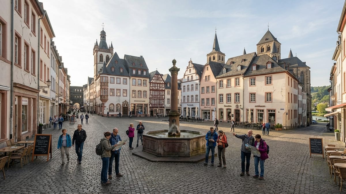
Old Town Core: From Hauptmarkt to the Cathedral Quarter
If Porta Nigra is the gate, Hauptmarkt is Trier’s living room. This triangular market square occupies a central position in the old town and functions as a natural pivot between Roman remains, medieval architecture, and 19th century shopfronts. Historic townhouses, gabled facades, and a late Gothic tower mark the transition from the straight Roman north south axis to more irregular medieval lanes.
From a map standpoint, Hauptmarkt works as your central node. From the square, Porta Nigra lies to the north, the cathedral quarter a short stroll east, and shopping streets along Brotstrasse and Neustrasse to the south and west. A few minutes of wandering in any direction leads you back to the square, making it an especially good place to reorient if you tend to stray down side alleys.
East of Hauptmarkt, in less than five minutes, the streets open out into Cathedral Square, where Trier Cathedral and the Church of Our Lady sit side by side. The cathedral, with its layered Roman, Romanesque, and Gothic fabric, occupies ground once used for a grand Constantinian church complex. The Church of Our Lady, an early Gothic structure, rises on the footprint of the southern part of that same complex. Together, they form a dense cluster of sacred architecture at the heart of the city map.
This cathedral district is also a useful practical landmark because several key pedestrian paths intersect here. One path links the square southward to the Aula Palatina and the old electoral palace; another leads back toward the Moselle river and the old Kornmarkt; yet another reconnects with Hauptmarkt. Seen from above, the area resembles a knot in the urban fabric where Roman, medieval, and modern routes are all tied together.
Imperial Power and Public Life: Basilica, Baths, and Amphitheater
Move slightly south from the cathedral quarter and you enter the zone where imperial administration and mass public entertainment once concentrated. The Aula Palatina, often referred to as the Basilica, sits just beyond the eastern edge of the old town. This brick hall was originally built under Emperor Constantine as an audience chamber. Today it functions as a Protestant church, but its sheer height and unbroken interior volume still convey a sense of imperial showmanship.
South of the basilica, the landscaped Palastgarten stretches across what was once a more formal complex of palace structures. From the fountain at its center, looking north, you see the brick bulk of the basilica; looking south, your eye is drawn toward the remains of the Imperial Baths. The garden thus becomes a pleasant green corridor between two of Trier’s most important Roman sites, and an easy way to orient yourself if you are navigating without a detailed map.
The Imperial Baths lie slightly downhill from the garden, in an open field crossed by footpaths. Their above ground remains are extensive, with arches, wall fragments, and underground service corridors that suggest how large the complex would have been when completed. Nearby, traces of the city wall and gate structures hint at the southern edge of the ancient city. Continue walking east around the baths and, in 10 minutes or so, you reach the amphitheater tucked into a natural hollow at the base of low hills.
The amphitheater’s location offers a different perspective on Trier’s map. Standing high on its terraces, you can look back toward the city center, tracing the line from baths to basilica to cathedral. It helps you appreciate how the Roman authorities arranged spaces for ceremony, bathing, and spectacle in a coherent band across the city’s southern flank. For visitors planning a day’s route, linking these sites into a single walking loop makes both historical and geographic sense.
The Moselle Riverfront: Bridges, Promenades, and Views
No mental map of Trier is complete without the Moselle. The river bends around the city’s western and southern edges, and several of its most atmospheric viewpoints lie along the riverbank. Walking from the old town to the water takes roughly 10 minutes, with Kornmarkt and the adjacent pedestrian streets forming a natural corridor down toward the riverfront.
The ancient Roman Bridge, known locally as the Römerbrücke, crosses the Moselle at the city’s southwestern edge. Its surviving stone piers date to the second century, making it the oldest bridge in Germany still in use. When you reach the eastern bank and look back, you frame Trier against the water, with church spires and hilltop vineyards beyond. This bridge is also an excellent reference point for longer walks along the river or for orienting yourself if you stay in riverside accommodation.
Modern Trier has developed a series of riverside promenades and green spaces along the Moselle, especially on the city side of the bridge. These walkways run parallel to the old town, providing shaded benches, landing stages for excursion boats, and views of passing barges. On a summer evening, strolling here offers a calmer counterpart to the bustle of Hauptmarkt. It also reveals how close the Roman and medieval city lay to the water, even if the primary monuments sit slightly inland.
For cyclists and long distance walkers, the riverfront becomes the primary axis, connecting Trier to neighboring wine towns and villages. From a mapping perspective, the Moselle functions as a huge navigational aid. If you are ever unsure where you are in relation to the historic center, simply find your way down to the river. From there, you know that heading inland and slightly uphill will bring you back into the orbit of Porta Nigra and the cathedral.
Planning Your Route: Practical Itineraries Across the Map
Because the historic core of Trier is compact, you can cover most of the city’s headline sights on foot in one long, well planned day. Start at Porta Nigra, then walk down through the old town to Hauptmarkt and the cathedral quarter. From there, continue to the Aula Palatina and palace gardens, explore the Imperial Baths, detour to the amphitheater, then circle back via the riverfront and Roman Bridge. The route forms a rough loop, minimizing backtracking and helping you see how the monuments line up geographically.
If you have two days, you can divide the city into thematic zones. Spend one day on the northern and eastern sectors, focusing on Porta Nigra, the old town squares, the cathedral and Church of Our Lady, the Aula Palatina, and the amphitheater. Reserve a second day for the southern and riverfront areas: the Imperial and Barbara Baths, the Roman Bridge, the Moselle promenades, and the Rheinisches Landesmuseum, which presents artifacts that put the city’s urban map in deeper context.
Public transport can supplement walking if you prefer shorter distances between sights. Buses link the main train station, Porta Nigra, and the riverside, while local routes reach outlying attractions and residential areas. However, within the central heritage area, walking remains the most efficient and rewarding way to understand how the city fits together. The subtle changes in elevation, the transitions between narrow lanes and open squares, and the sudden views of towers and ruins are all part of the experience.
When planning your day, it is worth keeping opening times and ticket combinations in mind. Several Roman monuments and museums can be accessed via combined tickets, and seasonal schedules may affect when interior spaces are open. Plotting these time windows on your mental map allows you to move efficiently from free outdoor sites, such as Porta Nigra’s exterior or the riverfront, to timed interior visits like bath complexes and museum galleries.
The Takeaway
Maps help visualize differences when comparing Trier vs Cologne. Trier rewards travelers who think in maps, not just in lists of sights. Once you understand how the Roman grid underpins the old town, how the cathedral quarter and basilica bookend the historic core, and how the Moselle frames everything, the city becomes straightforward to navigate. Porta Nigra, Hauptmarkt, the cathedral district, the southern band of baths and amphitheater, and the riverfront each act as distinct zones, stitched together by short, memorable walks.
This layered geography is part of Trier’s charm. You enter through a Roman gate, cross a medieval marketplace, stand in the presence of imperial brickwork, and finish beside Germany’s oldest bridge, all within a single compact circuit. For visitors armed with even a simple map and a sense of direction, the city offers not just monuments, but a clear story written into its streets. Understanding that story helps transform a day of sightseeing into a coherent journey through time, from the era of emperors to the present day.
FAQ
Q1: How much time do I need to see Trier’s main Roman monuments and old town?
Most travelers can see the major Roman monuments, the old town, and the riverfront in one full day of steady walking, but two days allow for a more relaxed pace and time in museums.
Q2: Is Trier’s historic center walkable for most visitors?
Yes, the distances between Porta Nigra, the cathedral, the baths, and the riverfront are short, though there are some gentle slopes; comfortable shoes are recommended.
Q3: Where should I start my walking tour of Trier?
Porta Nigra makes an excellent starting point, as it is easy to reach from the train station and sits on the northern edge of the old town, with clear routes to all other central sights.
Q4: How close is the Moselle riverfront to the old town squares?
The Moselle is roughly a 10 minute walk from the central squares such as Hauptmarkt and Kornmarkt, mostly along gentle streets that slope slightly downhill toward the river.
Q5: Can I visit the amphitheater and Imperial Baths on the same route?
Yes, the amphitheater and Imperial Baths lie near each other on the southern and eastern edge of the historic core and can be easily combined in one walking loop with the basilica and palace gardens.
Q6: Are there good viewpoints over Trier to understand the city layout?
The upper levels of Porta Nigra, the terraces of the amphitheater, and certain spots along the Moselle riverfront all provide helpful vantage points to grasp Trier’s overall map.
Q7: Do I need public transport to move between the Roman sites?
Within the central heritage area, most visitors rely on walking rather than buses or trams; public transport is more useful for reaching outer districts or nearby towns in the Moselle valley.
Q8: Is the Roman Bridge open to pedestrians?
Yes, the Roman Bridge carries modern traffic but also has pedestrian access, allowing visitors to walk across the Moselle and enjoy views back toward the city.
Q9: How can I avoid getting lost in Trier’s old town lanes?
Use Hauptmarkt and the cathedral square as reference points; most side streets eventually lead back to these central spaces or to the main pedestrian axis connecting them with Porta Nigra.
Q10: Are combined tickets available for Trier’s Roman monuments and museums?
Yes, the city typically offers combination tickets covering several Roman sites and sometimes museums, so it is wise to check current options at the tourist information office or museum ticket desks when planning your route.