
More news on this day
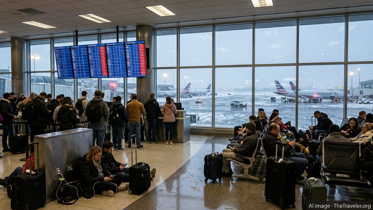
A sprawling late-season winter storm is disrupting air travel across the United States this week, with more than 4,000 flights canceled and thousands more delayed at major hubs including New York, Chicago, Atlanta and the Washington DC area, according to aviation tracking data and published media coverage.
Get the latest news straight to your inbox!
Major Hubs See Wave of Cancellations and Ground Delays
Flight tracking data for Monday, March 16 and Tuesday, March 17 indicates that US airlines have scrubbed over 4,000 flights systemwide as a strong winter system and associated bands of heavy snow, freezing rain and high winds sweep from the Midwest to the Northeast. The impact is concentrated at the country’s busiest connecting hubs, where ripple effects are spreading throughout domestic and international networks.
New York City’s three main airports, Chicago O’Hare, Atlanta’s Hartsfield Jackson and the Washington DC area airports have been among the hardest hit, with periods of ground stops and traffic management programs limiting takeoffs and landings as crosswinds and low visibility move through. Publicly available information from airline and airport dashboards shows rolling clusters of same day cancellations and multi hour delays as carriers attempt to keep some operations moving while protecting aircraft and crews.
Operational logs and media roundups describe an uneven pattern across the map. Some inland airports are dealing primarily with snow and runway clearing, while coastal hubs have been struggling more with wind shear, low clouds and bands of heavy rain on the storm’s warmer side. The result is a patchwork of localized disruptions that add up to nationwide strain on the aviation system.
New York, Chicago, Atlanta and Washington DC Bear the Brunt
In the New York region, LaGuardia, John F. Kennedy and Newark Liberty have all reported high volumes of weather related cancellations as the storm’s wind field moves up the Eastern Seaboard. Flight boards on Monday showed long blocks of red as airlines pulled frequencies on shorter shuttle style routes and trimmed selected transcontinental and transatlantic services, prioritizing core banked departures and long haul connections.
Chicago O’Hare has simultaneously been managing strong winds and intermittent winter precipitation, limiting the use of some runways and constraining the number of arrivals per hour. Social media posts and local coverage from the Chicago area describe congested gate areas, lines at customer service desks and aircraft waiting on taxiways for departure slots as controllers meter traffic into the airspace.
Farther south, Atlanta’s Hartsfield Jackson, normally a key pressure valve in the national network, has experienced its own wave of cancellations and rolling delays as storm cells and gusty winds have moved through the Southeast. Travelers report missed connections and overnight disruptions as carriers consolidate flights and reposition aircraft. With both New York and Atlanta affected at the same time, options for rerouting passengers around the worst of the weather have been limited.
In the Washington DC area, Ronald Reagan Washington National and Washington Dulles have also seen significant schedule cuts tied to heavy rain, low ceilings and wind. Published advisories for the wider Mid Atlantic corridor highlight constrained arrival rates into the capital region during peak hours, contributing to backups across the East Coast.
Knock-On Effects Across Secondary Airports and Regional Routes
Although the headline numbers are concentrated at the largest hubs, secondary airports and regional routes are also feeling the strain. When New York, Chicago or Atlanta reduce their arrival and departure rates, feeder flights from smaller cities are often among the first to be trimmed, as airlines work to preserve long haul and high demand trunk services.
Travelers connecting through hub cities from places such as the Midwest, the Carolinas, the Gulf Coast and inland Northeast report having flights canceled even when local weather remains relatively calm. Publicly available airline schedules show many of these passengers being rebooked on itineraries that require longer layovers, overnight stays or routings through alternative hubs that are less directly affected by the storm.
Regional jets and turboprop services are particularly vulnerable in this kind of event, since smaller aircraft are more sensitive to crosswinds and icing conditions. Industry analysts note that, as hubs come under pressure, airlines often consolidate multiple lightly booked regional flights into a single mainline departure once conditions allow, which can extend disruption for smaller communities well beyond the storm’s passage.
What Travelers Are Experiencing on the Ground
Reports from passengers on social platforms and local forums describe crowded terminals, long lines for rebooking and baggage assistance, and difficulty reaching airline call centers during peak disruption windows. At several major hubs, travelers recount receiving late night notifications that early morning departures were canceled, prompting last minute hotel searches or overnight stays in airport seating areas.
Other travelers describe watching their departures slip from minor delays into multi hour waits as air traffic control programs were extended in response to changing wind and visibility forecasts. In some cases, passengers have reported spending several hours on the tarmac awaiting clearance to depart or return to a gate, as limited ramp space and deicing queues slowed ground handling.
Amid the disruption, some airlines have issued broad weather waivers allowing customers traveling through affected airports to change their tickets without additional fees, subject to fare differences and rebooking windows. Public advisories from carriers emphasize the importance of using mobile apps and airport displays to monitor real time gate changes, as crew and aircraft reassignments continue through the day.
Outlook for the Coming Days and Practical Advice for Flyers
Forecast models indicate that the storm system will continue to push northeast into midweek, with gradually improving conditions in the Midwest and interior South, while parts of New England and Atlantic Canada see lingering snow, mixed precipitation and coastal wind. Even as skies clear over the busiest US hubs, analysts expect residual disruption to persist, as airlines work through aircraft repositioning, crew duty time limits and a backlog of displaced passengers.
Travel experts note that recovery from a large scale weather event of this type often takes at least one to two days beyond the end of significant precipitation or wind, particularly when multiple large hubs are affected at once. Travelers with flexible plans are being advised in public guidance to consider later departures in the week or to route through airports showing fewer cancellations on current tracking dashboards.
For those who must travel while disruption remains elevated, widely shared advice includes carrying essential items such as medications, chargers and a change of clothes in carry on bags, confirming flight status frequently, and considering same day alternatives such as nearby airports or different connection points. Passengers are also encouraged in consumer advocacy coverage to document expenses related to hotels and meals, in case they are eligible for reimbursement under airline policies or credit card travel protections once the immediate storm passes.