
More news on this day
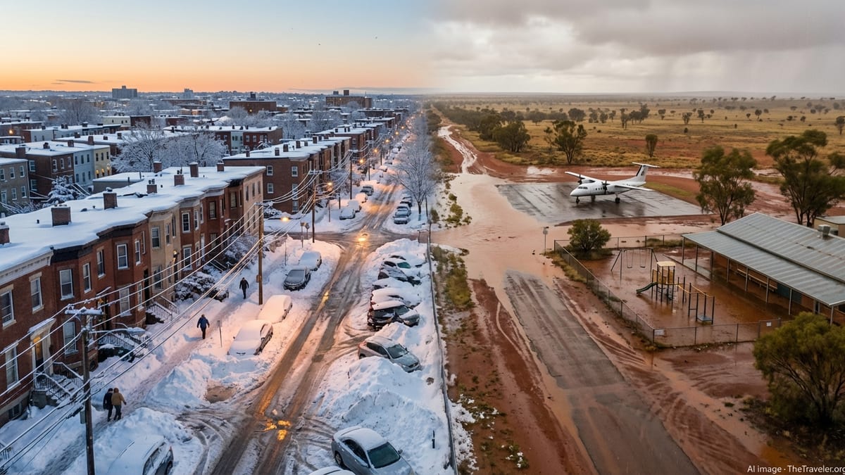
Winter Storm Hernando has brought parts of the northeastern United States to a standstill with blizzard conditions and record-breaking snowfall, while a slow-moving rain system linked to the same broader weather pattern has drenched central Australia, closing schools, grounding flights and forcing travellers to rapidly rewrite their plans on both sides of the globe.
Blizzard Conditions Paralyse the US Northeast
The powerful nor’easter, unofficially named Winter Storm Hernando, intensified rapidly off the Atlantic coast between February 22 and 24 before curling into the densely populated corridor from Washington to Boston. Meteorologists classified the storm as a classic bomb cyclone after its central pressure plunged by around 40 millibars in less than half a day, unleashing hurricane-force gusts along exposed capes and headlands.
New York, New Jersey, Rhode Island and Massachusetts bore the brunt of the system, with widespread reports of 2 to 3 feet of snow and towering drifts that quickly overwhelmed plough operations. In Rhode Island, snowfall totals approached 38 inches in places, while parts of southeastern Massachusetts and Long Island recorded more than 30 inches, ranking Hernando among the most severe blizzards to strike the region in decades.
Authorities across the Northeast declared states of emergency, imposed travel bans on major highways and urged residents to remain indoors as whiteout conditions reduced visibility to near zero. Coastal communities from New Jersey to Cape Cod also grappled with storm surge and tidal flooding as the deep low pressure system coincided with high astronomical tides.
At the storm’s peak, more than 600,000 homes and businesses across the region lost power as heavy, wet snow and wind gusts topping 80 miles per hour snapped trees and brought down transmission lines. Utility crews from across the eastern United States were drafted in, working through bitter wind chills to restore service in stages through the end of the week.
Schools Shut and Flights Grounded Across Key Hubs
With conditions deteriorating rapidly on Sunday night, major school districts in New York City, Boston, Providence and across New England announced blanket closures, shifting to remote learning where possible or cancelling classes outright. Some districts signalled that buildings would remain shut for days to allow snow removal teams to clear buried side streets, bus depots and school parking lots.
Air travel across the eastern United States was thrown into chaos as airports shut runways and air traffic controllers reduced operations to essential movements only. New York’s John F. Kennedy, LaGuardia and Newark Liberty airports, along with Boston Logan, saw waves of preemptive cancellations as airlines attempted to keep aircraft and crews out of the worst of the storm.
Industry trackers reported that more than 8,000 flights were cancelled over a 48 hour window as Hernando peaked, with knock-on disruption rippling across the national network. Transatlantic routes were heavily affected, with services between major European hubs and the US Northeast suspended or diverted, leaving thousands of passengers stranded in terminals from Dublin and Heathrow to Miami and Los Angeles as aircraft and crews fell out of place.
Rail and road travel fared little better. Sections of the busy Northeast Corridor rail line experienced reduced services or temporary shutdowns as drifting snow blocked tracks and overhead lines iced up in gale force winds. Interstate highways, including long stretches of I-95, were closed to non-essential traffic while multi-vehicle accidents and jackknifed trucks were cleared.
Human Impact and Recovery Efforts
Despite days of advance warning, the ferocity of Hernando still caught some communities off guard. Emergency services responded to hundreds of calls for stranded motorists, collapsed roofs and downed power lines as snow piled onto already saturated ground and winds intensified. At least a dozen fatalities across several states have been linked to the storm, including traffic accidents on treacherous roads and suspected cases of hypothermia and cardiac events associated with shovelling heavy snow.
In New York City, dramatic scenes played out as large trees, weighted down by the snowpack, toppled across streets and sidewalks, crushing parked cars and narrowly missing pedestrians. Viral video footage of one such incident, in which a child and a caregiver ran clear moments before a tree crashed to the ground in Manhattan, became emblematic of the storm’s sudden hazards.
By Friday, ploughs and snow blowers had carved canyons through towering roadside berms, and many main arteries were passable again, though side streets remained rutted and icy. Utility companies reported that the vast majority of customers had power restored, though pockets of rural New England and coastal communities were still relying on generators as crews worked through the final backlog of repairs.
Local tourism and hospitality businesses, including winter resorts that ordinarily welcome a surge of skiers after a big storm, reported a mixed picture. Fresh snow promised exceptional conditions in coming days, but travel shutdowns and lingering safety concerns meant many visitors postponed trips, undercutting the short term boost usually associated with a blockbuster blizzard.
Australia Swamped by Torrential Inland Rains
While the United States dug out from record snowfall, a related belt of tropical moisture and upper level instability delivered a very different kind of disruption across inland Australia. A slow moving low pressure system and associated trough streamed warm, humid air over central and eastern parts of the country, triggering days of torrential rain over regions more accustomed to parched summer landscapes.
Parts of outback Queensland, the Northern Territory and northern South Australia recorded more than 150 millimetres of rain in just 24 hours, with local gauges in some remote communities surpassing monthly averages in the space of a single day. Rivers that had shrunk to sluggish trickles after years of below average rainfall swelled rapidly, inundating low lying roads and cutting access to cattle stations and small townships.
Authorities in several states issued flood watches and warnings as creeks spilled their banks and water pooled across normally dusty plains. School closures were reported in smaller communities where school buses could no longer safely navigate submerged roads, and regional airlines suspended select routes into unsealed outback airstrips that became too soft and waterlogged to support safe landings.
For travellers, the heavy rains brought both disappointment and unexpected drama. Popular desert touring routes and remote four wheel drive tracks were abruptly closed, forcing tour operators to reroute or cancel multi day itineraries. In the Red Centre and along the edge of the Simpson Desert, visitors watched as normally dry creek beds transformed into rushing, ochre coloured torrents, creating rare waterfalls and ephemeral lakes that locals described as a once in a decade spectacle.
Climate Context and Travel Outlook
The trans-hemispheric contrast between Hernando’s snowbound Northeast and Australia’s rain soaked interior has renewed attention on how a warming climate can amplify existing weather extremes. Scientists note that while no single storm can be blamed solely on climate change, the backdrop of higher global temperatures is loading the dice toward more intense precipitation events, whether as snow in cold regions or as tropical downpours in the subtropics.
For travellers and the tourism industry, the past week has underscored the importance of flexible planning and real time information. Airlines serving the US East Coast and Australia have once again expanded their change fee waivers, encouraging customers to monitor official forecasts and airport advisories closely before setting out. Travel insurers are urging policyholders to document delays and cancellations, as claims related to severe weather spike with each new disruptive event.
In the northeastern United States, attention is already shifting from emergency response to recovery and opportunity. Resorts in upstate New York, Vermont and New Hampshire are racing to groom an exceptional snowpack that could extend the ski season well into spring, even as coastal cities work to clear mountains of ploughed snow and restore normal commuting patterns. City tourism boards are hopeful that once transport networks stabilise, the fresh snow will lend a picturesque backdrop for late winter visitors.
Across Australia’s interior, floodwaters are expected to linger in low lying basins and river systems for days or weeks, gradually recharging groundwater and transforming arid landscapes into fleeting carpets of green. While some tracks and unsealed roads may remain closed for an extended period, tourism operators are already planning to market the explosion of wildflowers and birdlife that typically follows such rare soaking rains, turning a week of disruption into a drawcard for the seasons ahead.