
More news on this day
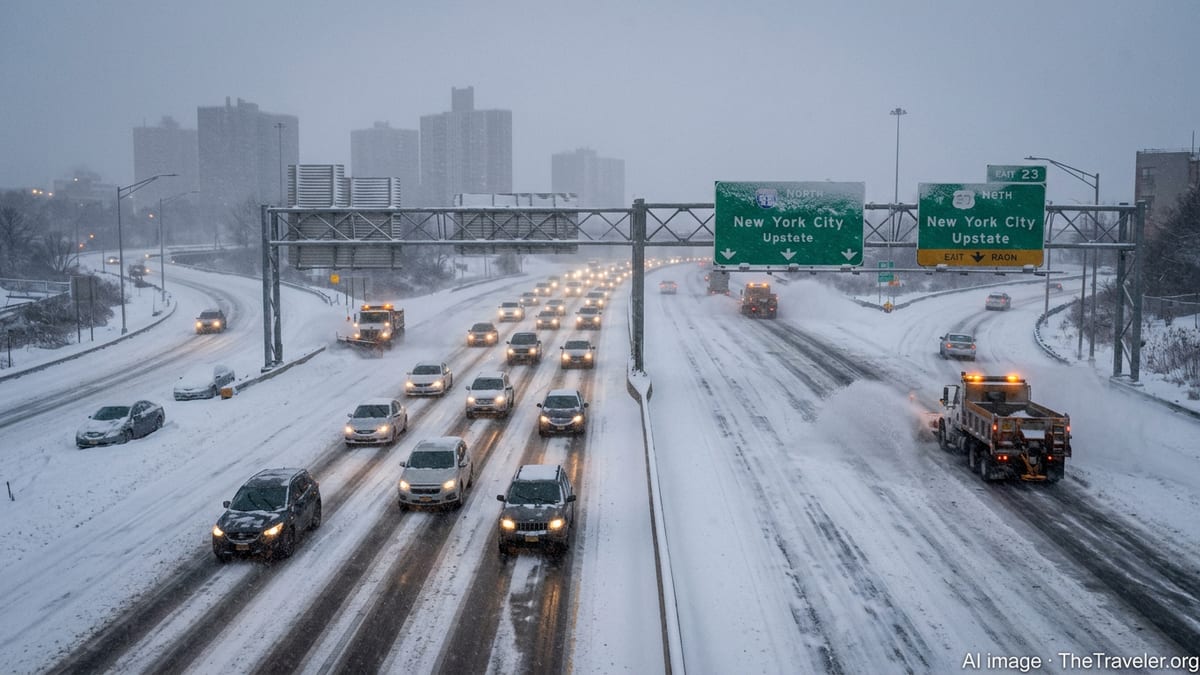
A fast-developing winter storm is bringing hazardous blizzard conditions to parts of New York, with nine counties under the highest-level warning as heavy snow and strong winds combine to snarl travel, close roads and disrupt air and rail traffic across the region.
Get the latest news straight to your inbox!
Blizzard Conditions Spread Across Downstate and Upstate New York
Publicly available information from the National Weather Service indicates that a powerful coastal system interacting with Arctic air is producing blizzard conditions across sections of New York, triggering warnings that now cover nine counties. The alerts focus on areas where sustained winds and wind gusts are strong enough to whip deepening snow into whiteout conditions and drive visibility below one quarter of a mile for prolonged periods.
The warned zones include a mix of coastal and interior counties, with priority concern for low visibility, drifting snow and rapidly changing conditions on highways and secondary roads. Forecast guidance points to snowfall totals that may exceed 30 centimeters in the hardest-hit locations, with localized higher amounts where bands of heavier snow persist.
Temperatures hovering well below freezing are expected to keep snow dry and easily windblown, a combination that favors near-continuous ground blizzards and deep drifts. Public bulletins stress that even short trips could become dangerous if vehicles are stranded in blowing snow and falling wind chills.
Road, Rail and Air Travel Severely Disrupted
Travel impacts are already extensive, with transportation agencies and carriers posting a wave of cancellations and delays across New York and the broader Northeast. Published coverage from regional media shows hundreds of flights scrubbed at major airports serving the New York metropolitan area as airlines consolidate schedules ahead of the storm’s peak intensity.
On the ground, long-distance and commuter rail services are operating on reduced or modified timetables, with some routes curtailed outright where heavy drifting has made track clearing difficult. Bus operators are limiting or suspending service on select intercity and suburban lines, especially during the overnight hours when visibilities are expected to be worst.
State and local transportation departments report deteriorating road conditions on major corridors, including stretches of interstate highway where plows are struggling to keep pace with rapidly accumulating snow and strong crosswinds. Motorists who choose to travel are being urged through public advisories to carry winter emergency kits, maintain full fuel tanks and be prepared for sudden closures or long delays.
Power Outage Risks and Coastal Hazards Add to Concerns
Beyond the immediate travel turmoil, the combination of heavy, wind-driven snow and gale-force gusts is raising the risk of scattered power outages across parts of New York. Energy utility updates and prior storm assessments show that strong winds can topple tree limbs into overhead lines, while accumulating snow and ice increase stress on already vulnerable infrastructure.
Coastal communities along Long Island and the lower Hudson estuary are contending with additional threats from rough surf and periods of minor to locally moderate coastal flooding, according to marine and tidal forecasts. High tides coinciding with the storm’s strongest winds may push water into low-lying roadways and transit-adjacent neighborhoods, complicating any evacuation or emergency access needs during the height of the blizzard.
Emergency management guidance released ahead of the storm emphasizes the compounding effect of simultaneous hazards. Residents in at-risk areas are being encouraged through publicly available advisories to secure outdoor items that might become airborne, prepare for short-notice power interruptions and avoid coastal flood-prone routes once snow begins to obscure lane markings and storm drains.
Travelers Urged to Rethink Itineraries and Monitor Local Updates
For travelers heading into, out of or through New York during the storm window, widely shared forecasts and transportation notices recommend postponing nonessential trips whenever possible. Airlines and rail operators are broadly waiving change fees and offering flexible rebooking options, acknowledging that conditions at hubs from New York City to upstate terminals may remain unstable for some time even after the snow tapers off.
Those who must be on the move are advised in public guidance to check airline and carrier status repeatedly, as schedules are being adjusted dynamically hour by hour. Road travelers are encouraged to use official traffic and weather alert channels, as localized whiteouts and drifting can shut down individual highway segments even when nearby stretches remain passable.
Travel planners note that the disruptive footprint of the storm extends beyond New York itself, touching connecting hubs across the Mid-Atlantic and New England. Delays and cancellations in the storm zone are rippling outward, with some long-haul flights diverted or rerouted, and overnight rail sleepers and bus corridors forced to change routing to safer inland paths.
Looking Ahead: Slow Improvement After a Dangerous 24 Hours
Forecast discussions suggest that conditions across the nine New York counties under blizzard warning will begin to improve only gradually after the storm’s main snow shield pulls away. Winds are expected to remain strong for several hours even as snowfall rates drop, which means blowing and drifting snow may continue to make travel hazardous well into the following day.
Publicly available outlooks show that cleanup operations are likely to be complicated by deep drifts, stranded vehicles and lingering icy patches where compacted snow has bonded to pavement. Transportation agencies typically prioritize major freight and emergency corridors first, so travelers using rural routes and secondary highways should expect slower progress on snow removal.
As the region emerges from the storm, attention will turn to the broader winter pattern and whether additional systems might follow on its heels. Seasonal outlooks for the 2025 to 2026 winter have highlighted the potential for sharp swings between mild and extreme conditions, a backdrop that leaves travelers and local communities highly sensitive to each new round of heavy snow and strong winds.