The Danube is one of the few rivers in the world that can genuinely be called a journey. From the medieval streets of Bavaria to the wide, reed fringed channels of the Black Sea delta, a Danube river cruise traces a line through the heart of Europe, crossing language borders, former imperial frontiers and some of the continent’s most cinematic landscapes.
Understanding the map of this route, and how itineraries piece together the geography of the river, is the key to choosing the voyage that best matches your travel style.
How the Danube Connects Germany to the Black Sea
The Danube rises in the Black Forest of southwest Germany, then flows for roughly 1,770 miles through 10 countries before pouring into the Black Sea in Romania. For modern travelers, the cruiseable stretch that matters most begins in Bavaria, links to the Rhine through the Rhine Main Danube Canal, and then follows the river southeast through Austria, Slovakia, Hungary, Croatia, Serbia, Bulgaria and Romania.
This navigable corridor is possible because of 20th century engineering. The Rhine Main Danube Canal, completed in 1992, bridged a missing overland gap between the Main and Danube river basins in northern Bavaria.
Today, a ship that starts in the North Sea or on the Rhine can sail continuously all the way to the Danube Delta without leaving inland waterways, climbing through a staircase of locks to a summit more than 400 meters above sea level before descending again to the lowlands of southeastern Europe. Visualizing the route helps explain why these Danube cruise itineraries are structured the way they are.
On the map, most cruise itineraries between Germany and the Black Sea cover only a portion of this full route, but a handful attempt the full “North Sea to Black Sea” vision. Others focus specifically on the classic Danube corridor between Passau or Regensburg in Germany and the delta, often broken into segments such as “Upper Danube” and “Lower Danube.” Understanding where these segments start and end will help you see how your ship’s path fits into the larger geography of the river. Maps are also useful when comparing Danube cruises vs Rhine cruises geographically.
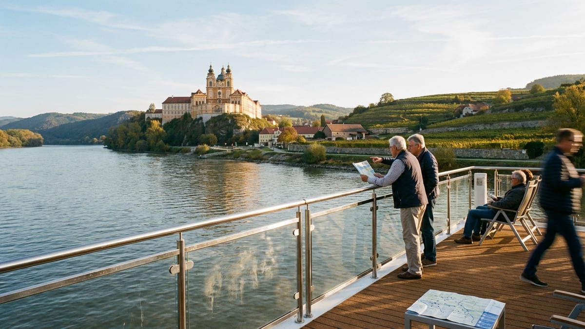
Upper Danube: Bavaria to Vienna
For many travelers, the journey begins in Bavaria. River ships frequently embark in Passau or Regensburg, compact German cities where Gothic spires and pastel facades overlook the water. From here, the Danube swings east and then southeast, carving through gentle hills and passing small river ports like Linz before entering Austria’s most scenic reach.
Between Melk and Krems lies the Wachau Valley, one of the best recognized slices of the Danube map. Here the river narrows and bends between terraces of vineyards, ruined castles and baroque monasteries perched on cliffs. The Benedictine abbey at Melk, with its golden façade and library of medieval manuscripts, dominates this stretch, and cruising guides often highlight the Wachau as the quintessential “Blue Danube” scene that inspired artists, composers and Romantic era travelers.
Downstream, the river broadens again as it approaches Vienna. The Austrian capital lies slightly back from the main navigation channel, linked by side arms and canals, but for cruise passengers it becomes an anchor point. Even short itineraries that start or end in Vienna treat it as a centerpiece of the Upper Danube, a city of palaces, coffeehouses and concert halls where passengers often spend a full day or more.
Middle Danube: Vienna to the Hungarian Plain
From Vienna, the Danube traces a short but politically symbolic route to Bratislava, capital of Slovakia. On the map the two cities are just over 50 miles apart, which makes it possible to sail between them in a few hours. High speed catamarans even shuttle day trippers between the two, underlining how this section of river functions as a living corridor between neighboring capitals as much as a scenic passage for leisure travelers.
After Bratislava the Danube heads eastward through a wide valley that once formed part of the Habsburg frontier, then angles south toward Hungary. It passes Komárno and Esztergom, both rich in ecclesiastical and military history, before the skyline of Budapest emerges. Many Danube cruise maps emphasize this moment: the city is split by the river into Buda and Pest, with the domed Parliament, Chain Bridge and hilltop castle district forming one of Europe’s most dramatic urban riverfronts.
Downstream of Budapest, the river begins to feel wilder and more spacious. The flatlands of the Hungarian plain stretch away on both sides, and the Danube broadens into long, straight reaches punctuated by river islands and side channels. While shore excursions here often focus on traditional ranch culture or regional wine towns, the map also shows the river drawing closer to yet another border, where Hungary gives way to Croatia and Serbia.
Lower Danube: Through the Balkans to the Black Sea
The Lower Danube covers the long, lesser known half of a Germany to Black Sea cruise. South of Hungary, the river traces frontiers and crosses old boundaries that once divided empires and, more recently, countries emerging from conflict. For river cruise passengers, this is where itineraries feel more adventurous: ports are smaller, landscapes more rugged and cultural contrasts more pronounced from one day to the next.
Most voyages continue through Croatia and Serbia, with stops in places like Vukovar or Novi Sad, before reaching Belgrade. The Serbian capital sits at the confluence of the Sava and Danube rivers, a position that has made it both strategic and contested for centuries. On the map it marks an informal midpoint of the Lower Danube: upstream lies the former Habsburg and Ottoman borderland; downstream, the river bends toward the Carpathian and Balkan mountains and cuts a dramatic route between them.
The Iron Gates gorge, straddling the boundary between Serbia and Romania, is one of the signature highlights of any Black Sea oriented itinerary. Here the Danube funnels between steep walls of limestone, at times feeling more like a mountain lake than a river. Massive dams and locks built in the 20th century tamed the rapids and raised the water level, but even today the narrowest points remain striking and create a sense of passage from Central to Southeastern Europe.
Beyond the gorge, the Danube forms a broad natural border between Romania on the north bank and Bulgaria to the south. Cruise maps typically show a chain of smaller ports here, such as Ruse, Vidin and Giurgiu, each providing access to inland cities and rural regions that see far fewer visitors than Vienna or Budapest. This is also where some itineraries insert coach excursions to the Romanian capital Bucharest, often marketed as a kind of “bonus” city near the end of a long river journey.
The Danube Delta and the Approach to the Black Sea
As it nears the Black Sea, the Danube begins to fragment. On the map, the single blue line that traced an almost continuous course from Germany suddenly splits into a lacework of channels. These distributaries form the Danube Delta, one of Europe’s largest wetlands and a protected biosphere reserve recognized for its birdlife, shifting sandbars and labyrinth of reed beds.
For cruise travelers, reaching the delta feels like a natural culmination. Large river ships often use the main shipping canal to approach seaports such as Constanța or nearby river towns linked to the coast. Smaller excursion boats may then take passengers into quieter side channels where pelicans and herons feed, fishermen work from simple wooden skiffs and villages cluster on narrow strips of higher ground between waterways.
Not every Germany to Black Sea itinerary ventures deep into the delta, but many include at least a taste of this landscape. You might visit a local community, sample fish stew prepared in an outdoor cauldron, or simply sit on deck while the ship glides past low, marshy islands at the threshold of the open sea. On the map, this section appears as a tangle of water and land; in reality, it feels like a slow dissolving of the river you have followed for hundreds of miles.
Understanding Typical Danube Cruise Maps and Itineraries
When you look at a Danube river cruise map in a brochure or on a booking page, the route is usually reduced to a simple line dotted with port names. Behind that line is a carefully measured sequence of sailing days, lock transits and shore excursions that has to fit the realities of navigation on a working waterway. Recognizing the main patterns will help you decode what is being offered.
Most operators break the river into three commercial segments. Upper Danube itineraries usually run between Germany or Austria and Budapest, highlighting Bavaria, the Wachau Valley, Vienna, Bratislava and the Hungarian capital. Middle or “classic” Danube trips may link Budapest and Belgrade or continue slightly further into the Balkans. Lower Danube and Black Sea programs cover the reach between Budapest or Belgrade and ports in Romania and Bulgaria, often with a foray into the delta and a transfer to or from Bucharest.
A true “Germany to the Black Sea” voyage usually combines at least two of these segments, if not all three, into a single extended itinerary of two to four weeks. On the map, this longer route often appears as a sweeping arc across the continent, sometimes tied into the Rhine via the canal. The more compact the map looks, the more sailing days and overnight port calls are being compressed into a single visual. It can be helpful to cross check the distance with the number of nights to understand how quickly your ship will be moving.
The map also rarely shows the many locks and canal sections that make through navigation possible. Between the Main and the Danube, for example, ships climb and then descend via a series of locks that lift them more than 170 meters from one basin to the other. These transits can become part of the onboard experience, but they are not marked as stops. When reading a map, remember that the line represents not just pretty bends and capitals but also the engineered backbone that keeps Europe’s waterways connected.
Choosing Embarkation and Disembarkation Points
Because the Danube passes through so many countries and major cities, cruise maps present travelers with multiple entry points into the river. In Germany, Passau and Regensburg function as common gateways, both small enough to feel walkable yet well connected by rail to Munich and other hubs. Choosing one of these as a starting point allows you to begin in a historic river town rather than a larger metropolis, easing into the rhythm of river life.
Further downstream, Vienna and Budapest serve as both midpoints and turning points. Many itineraries that do not attempt the full Germany to Black Sea route will run between these capitals and one of the upstream German ports. Conversely, Lower Danube voyages may begin or end in Budapest while focusing most of their time on the Balkans and the approach to the Black Sea. When the map shows an itinerary starting in one capital and ending in another, take note of which parts of the river you will see by daylight and which sections you are more likely to pass overnight.
At the Black Sea end, itineraries often list river ports such as Oltenița, Cernavodă or Giurgiu, along with mentions of Bucharest or Constanța. On the map these names may appear close together, but in practice they involve coach transfers between riverfront dockings and inland or coastal cities. Understanding this will help you set realistic expectations. You may sleep on the river but spend your final full day on buses and city tours before or after the ship has actually reached the sea.
Another factor is seasonality. In some years, summer heat and low rainfall can cause Danube water levels to drop, especially in parts of Central Europe. When this happens, cruise companies sometimes adjust embarkation points, bus passengers around shallow stretches or modify the sailing route. While maps in brochures show the idealized course, it is worth remembering that river conditions are dynamic and that exact embarkation and disembarkation locations can shift in response.
Reading the River: Practical Map Tips for Travelers
Beyond simply tracing where your cruise begins and ends, taking time to study a Danube map can greatly enhance how you experience the journey day to day. Start by noting which stretches of river the itinerary highlights as scenic cruising. These are usually the Wachau Valley in Austria, the river loop near Schlögen in Germany, the Bratislava to Budapest corridor and the Iron Gates gorge in the Balkans. On many itineraries, ships schedule these passages for daytime hours so that passengers can be on deck as the landscape unfolds.
Next, pay attention to the orientation of the river. Although the Danube generally flows east and southeast, it includes many north south and west east bends. In certain sections, particularly in the Iron Gates and the Hungarian plain, the direction of travel can feel less intuitive than following a single eastbound line. Checking the map ahead of time can help you understand which bank corresponds to which country and why you may cross the same border multiple times in a single day.
The political geography is also visible in how ports are spaced. In the Upper Danube, major stops are relatively close together and anchored by sizable cities. In the Lower Danube, the map shows longer distances between ports and more emphasis on natural features like gorges and wetlands. This means that in the upstream half of a Germany to Black Sea cruise, you may have more frequent opportunities for city walks and museum visits, while the downstream half leans more toward scenery, village life and archaeological or religious sites.
Finally, consider how your time on the river lines up with daylight at your chosen season. On the map, the Danube passes through a fairly wide range of latitudes. In early spring and late autumn, evenings in Central Europe can be dark by late afternoon, while summer brings long twilight hours, especially in the northern sections. Aligning your expectations about what you will see from the ship with the calendar and the route can help you decide whether to prioritize iconic city skylines, vineyards or the more remote landscapes of the Lower Danube.
The Takeaway
A Danube river cruise from Germany to the Black Sea is not just a list of ports; it is a mapped story of Europe unfolding in slow motion. Starting among Bavarian steeples, you glide past Wachau vineyards and imperial capitals, then slip into quieter reaches where the river has long marked borders and linked cultures at the edge of empires. By the time the water fans out into the broad, shimmering delta, you will have crossed a continent in the most literal way.
Spending time with the map before you book, and again before you sail, helps transform the journey from a series of excursions into an understandable whole. You will know when the ship is moving between linguistic zones, when you are entering a new country and when engineering feats like locks and canals are carrying you over invisible divides in the landscape. The voyage becomes not only scenic but legible, a chance to read history, geography and culture in the flow of a single river.
Whether you choose a compact Upper Danube itinerary or commit to a full Germany to Black Sea odyssey, the river’s broad arc through Europe rewards curiosity. The more you understand the route, the more each bend, bridge and skyline gains meaning, turning your time on board into a rich, continuous narrative rather than a series of disconnected stops.
FAQ
Q1. How long does a Danube river cruise from Germany to the Black Sea usually take?
Most full length itineraries that link Germany with the Black Sea take between 14 and 29 days, depending on whether they also include sections of the Rhine or only focus on the Danube corridor between ports such as Passau and the delta region.
Q2. Which countries will I visit on a typical Germany to Black Sea Danube cruise?
A comprehensive itinerary usually includes Germany, Austria, Slovakia, Hungary, Croatia or additional Balkan states, Serbia, Bulgaria and Romania, with many cruises also offering overland excursions to inland capitals like Bucharest that are not directly on the main navigation channel.
Q3. Where do most cruises that head toward the Black Sea start in Germany?
Passau and Regensburg in Bavaria are the most common German embarkation ports for Danube cruises, as both sit directly on the river, are close to key canal connections and offer convenient rail links to larger cities such as Munich.
Q4. Do all Danube cruises actually reach the open Black Sea?
No, many itineraries end at delta region river ports or nearby towns and then provide coach transfers to coastal cities, so your ship may navigate through the lower Danube and parts of the delta without sailing into the open sea itself.
Q5. What is the difference between Upper and Lower Danube cruises?
Upper Danube cruises concentrate on the sections between Germany or Austria and Budapest, focusing on major cities and wine regions, while Lower Danube cruises explore the stretch from Budapest or Belgrade to Romania and Bulgaria, emphasizing gorges, borderlands and the approach to the Black Sea.
Q6. How do water levels affect Danube cruise itineraries?
Periods of unusually low or high water can limit navigation on certain stretches, especially in Central Europe during late summer or after heavy rains, and in those cases cruise lines may adjust embarkation points, alter daily schedules or use buses to bridge problematic sections while keeping the overall route as close as possible to the planned map.
Q7. Is the Iron Gates gorge included on all Black Sea bound itineraries?
Almost every Danube cruise that extends into the Balkans and toward the Black Sea passes through the Iron Gates, since it lies directly on the main river between Serbia and Romania and forms one of the least avoidable and most memorable segments of the route.
Q8. Can I join only part of a longer Germany to Black Sea voyage?
Yes, many operators sell the extended route in segments, allowing you to book just the Upper Danube, only the Lower Danube, or a mid section that links capitals, even when these segments are also marketed together as a single grand cruise across Europe.
Q9. How much time do cruises spend in big cities like Vienna and Budapest?
Most itineraries schedule at least one full day and often an overnight stay in key capitals, which means you usually have daytime touring plus the chance to experience the city illuminated at night before the ship departs on the next leg of the journey.
Q10. When is the best time of year to sail from Germany to the Black Sea on the Danube?
Late spring and early autumn are often considered ideal because temperatures along the route are generally comfortable, daylight is still generous and river conditions are typically more stable than during peak summer heat, though the best choice ultimately depends on your tolerance for busy ports versus quieter, shoulder season travel.