
At first glance, Vienna’s Donauinsel looks like a stroke of luck from nature: a slim green strip of parkland flanked by shining water, stretching as far as the eye can see. In reality it is one of Europe’s boldest pieces of river engineering, a 21 kilometer artificial island built not for postcard views but to keep a capital city safe from the Danube’s devastating floods.
Over time, this concrete idea turned into something softer and more surprising: Vienna’s biggest outdoor playground, the scene of world record breaking music festivals, nude beaches, quiet wetlands and serious climate adaptation experiments. For travelers, understanding why this island exists in the first place changes the way you walk its paths and swim its shores.
From Wild River to Engineered Landscape
To understand Donauinsel, you need to picture the Danube as it once was. Before modern regulation works, the river ran through Vienna as a tangled braid of channels and wetlands, sometimes up to eight kilometers wide. In spring and after heavy rain in the Alps, the water could surge without warning. Over the centuries, floods repeatedly inundated low lying suburbs, destroyed homes and infrastructure and periodically cut off parts of the city.
In the late 19th century, Vienna undertook its first grand Danube regulation. Engineers dug a new straightened main channel and built high embankments to tame the river and make room for urban expansion. The works dramatically reduced flooding within the new protected corridor but did not fully solve the problem. Extreme events at the end of the 19th and mid 20th centuries showed that, under the right conditions, the Danube could still overwhelm the existing embankments and threaten the city once more.
By the 1960s, Vienna’s population had grown and its economic assets along the river had multiplied. At the same time, hydrologists were refining their estimates of how much water the Danube could carry in an extreme, very rare flood. The numbers were sobering. To avoid a future disaster, the city and the national government needed a second, more ambitious phase of flood protection. Rather than simply raising levees again, planners considered a new approach: giving the river more space by adding a second channel and a long barrier between the two waterways.
This idea matured into a dual system of main Danube and “New Danube” flood relief channel running in parallel through the city. The material excavated to dig that new channel would form an artificial island in between. What sounds like a stroke of aesthetic genius was in truth a very practical decision: turn a mass of gravel and earth that would otherwise have to be trucked away into something that shaped the river, sheltered the city and, as it turned out, opened enormous recreational potential.
The Second Danube and the Birth of Donauinsel
Construction of the new Danube regulation began in 1972 and continued until 1988. Engineers excavated a 210 meter wide, 21 kilometer long relief channel now known as the Neue Donau. The excavated material, some 20 million cubic meters by various estimates, was used to raise and shape a slim island between the old and new channels. In cross section, the whole system works like a large safety valve: the main river remains in its normal bed most of the time, while the second channel stays relatively calm and lake like.
At both ends of the system, massive weirs control how much water flows into the Neue Donau. In normal conditions, these structures stay largely closed, and the Neue Donau behaves like an elongated urban lake, ideal for swimming, paddling and watersports. When forecasts predict an extreme flood, the gates are gradually opened. Water then surges into the relief channel, which can carry several thousand cubic meters per second and ease pressure on the main river. The island in between forms a raised barrier that ensures the Danube’s peak levels remain within safe limits for Vienna’s embankments and riverside districts.
The Donauinsel’s dimensions are striking: around 21.1 kilometers long but often barely 70 to 210 meters wide. It is a long green knife laid between two sheets of blue. Much of its bulk consists of compacted gravel and earth armored with stone on the waterward side. Behind the practical details lies a piece of quiet good fortune. Because the island is relatively narrow, paths and grassy areas are always close to the water, something that gives the whole space an immediate and accessible feel for visitors.
By the time the last pieces of the flood protection works were completed in the late 1980s, the system had already passed major real world tests. Large floods in 1991 and, more dramatically, the Central European deluge of 2002 saw the Neue Donau channel in full operation, taking huge volumes of water away from the main river. Where previous generations would have witnessed catastrophic inundations, Vienna saw limited impacts, and the city’s dense core remained safe. That reliability is the blunt, life sized reason the island exists at all.
From Lifesaver to Living Room: Vienna’s Outdoor Playground
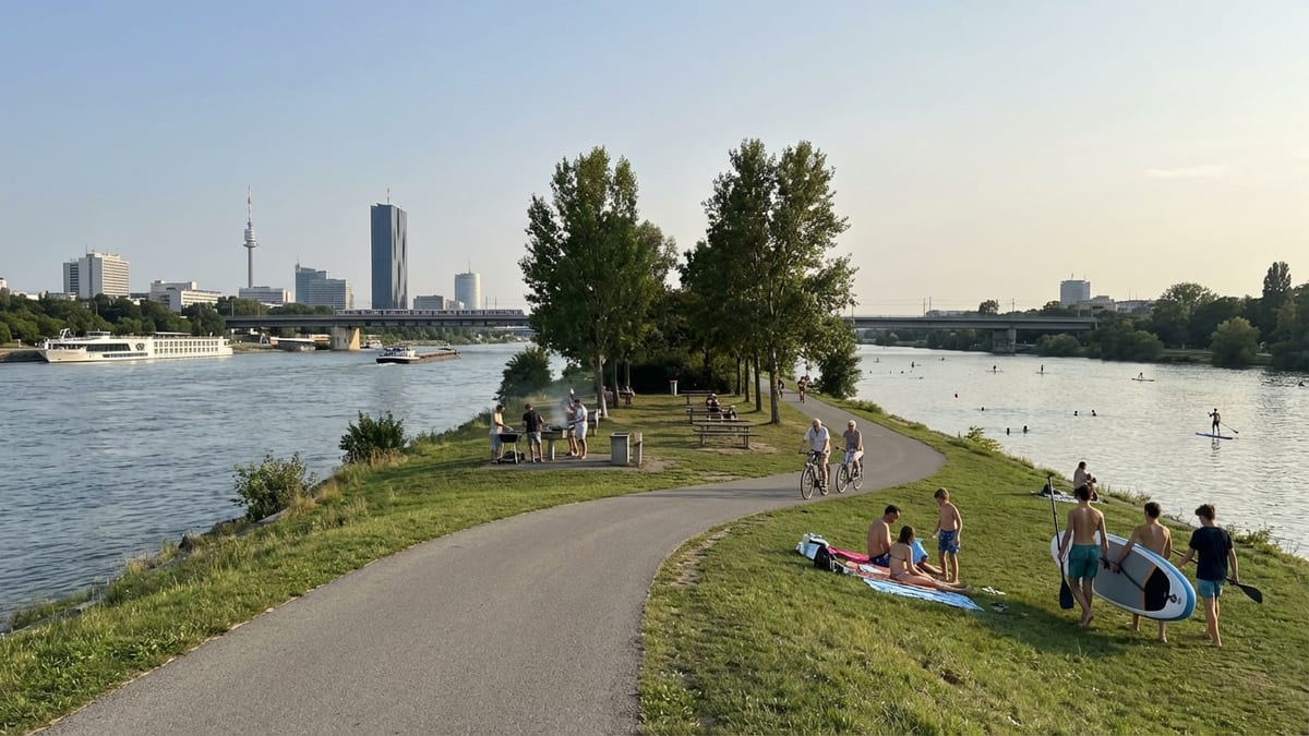
If the story ended with engineering, Donauinsel would be impressive but not compelling as a travel destination. What sets it apart is what came next. Almost as soon as work began, planners realized that this giant piece of hydraulic infrastructure could double as a park. The island’s western flank borders the main Danube, with its shipping traffic and cruise boats. The eastern side, along the Neue Donau, is comparatively tranquil. Seen from the center, the strip becomes a vast outdoor terrace for the city.
Over the years, Vienna has turned that terrace into one of its most beloved public spaces. Long asphalt and gravel paths run along both shorelines, making the island a natural highway for cyclists, skaters and runners. Small footbridges and metro bridges connect it with districts on either side, so local residents can be on the island within minutes. Many sections remain purposefully simple: trees, meadows, sloping banks where you can walk down to the water and dangle your feet in the Danube.
Elsewhere, clusters of activity give the island a more animated face. There are designated barbecue zones with fixed grills where families gather on summer evenings, playgrounds and a wildly imaginative water park for children, beach volleyball courts, skate parks and dog areas. In the warmer months, floating bars and simple riverside kiosks open up, especially around the lively “Copa Beach” zone facing one of the island’s most built up sections. For visitors, it feels like an urban beach resort sitting just beyond the reach of Vienna’s grand 19th century boulevards.
The subtle genius is that most of this infrastructure is deliberately light touch. Donauinsel is not a theme park but a linear commons where organized facilities share space with open lawns, copses of trees and patches of rougher habitat. You can bike for kilometers passing only casual swimmers and sunbathers, then suddenly emerge by a cluster of cafés and a splash of electronic music. That alternation between calm and activity is one of the island’s pleasures.
A Festival Island: Donauinselfest and Big Events
Every June, the island’s quiet stretches give way to one of Europe’s most extraordinary urban spectacles. Donauinselfest, Vienna’s free open air music festival, transforms a central section of Donauinsel into a dense tapestry of stages, food stands and themed zones. Since its beginnings in the 1980s, the event has grown into the world’s largest music festival by attendance, welcoming between two and three million visitors over a single long weekend.
For the city, the festival is more than a weekend party. It is a showcase of how the island’s flood protection backbone allows for high intensity events without occupying scarce inner city squares and parks. The festival grounds typically stretch for about four and a half kilometers between major Danube bridges, creating a walkable universe of music, comedy, cultural stands and youth projects. Crucially, admission is free, keeping the event accessible and giving it the atmosphere of an enormous communal gathering rather than an exclusive concert series.
As a visitor, Donauinselfest is one of the most vivid ways to understand the island’s dual character. The same grassy banks that host picnics and reading sessions for most of the year become viewing slopes for rock, pop and electronic acts. Metro trains deliver festivalgoers directly onto footbridges, dispensing them onto the long spine of the island. And yet, a short bike ride away, quieter stretches remain relatively untouched. Even during the festival, Donauinsel is big enough to hold crowds and solitude at the same time.
Outside of Donauinselfest, the island also accommodates major sporting events, from European beach volleyball championships to long distance races and triathlons. Its flat profile, controlled water conditions in the Neue Donau and easy access from multiple districts make it a ready made arena. For travelers planning a trip around an event, the island offers the rare combination of big stage energy and easy escape into nature just a few hundred meters away.
Ecology, Climate Resilience and a Changing Danube
Behind the leisure activities, Donauinsel has quietly become a laboratory for urban ecology and climate adaptation. When the island was first built, planners planted millions of trees and shrubs to bind the soil, create shade and soften what might have been a harsh embankment. Over time, these plantings have matured into a patchwork of groves and meadows that support birdlife, insects and small mammals. For a city of its size, Vienna benefits from an unusually large strip of semi natural riverside habitat right at its doorstep.
In recent years, concern about hotter summers and more intense rain events has given this green infrastructure new weight. Projects on the island now focus on strengthening ecosystems so they can withstand heatwaves, droughts and more erratic water levels. Measures include creating small wetlands, establishing more diverse planting schemes and tackling invasive species that could destabilize local biodiversity. The goal is to let Donauinsel function not only as a physical barrier to floods but also as a sponge, moderating temperature extremes and holding water in periods of scarcity.
For visitors, these efforts may not be immediately obvious, but they shape the atmosphere of the place. Shaded paths under tall trees are a deliberate response to rising urban temperatures. Rewilded sections with deadwood and varied grasses are part of a conscious choice to favor richer ecosystems over manicured lawns. Information boards in German and sometimes English explain aspects of river dynamics and habitat restoration, turning an afternoon walk into a low key lesson in how Europe’s great rivers are being reimagined for a warmer, less predictable climate.
Seen in this light, Donauinsel can be read as a model that other river cities study closely. It shows that flood protection need not mean simply building ever higher walls. By giving the Danube more room to expand safely, Vienna created a multi use landscape that increases safety, improves health and offers everyday contact with water and nature. For the traveler, that broad context adds a layer of meaning to even the simplest act of dipping into the Neue Donau on a hot day.
Experiencing Donauinsel: What It Feels Like on the Ground
To grasp what Donauinsel means to Vienna today, it helps to set the theory aside and imagine an actual visit. Step off a metro train at one of the Danube crossings, follow the flow of cyclists and walkers up a ramp, and suddenly the city changes texture. Apartment blocks, tram lines and office towers drop behind you, replaced by open sky, flashing water and the soft rhythms of joggers’ footsteps.
On a summer afternoon, the eastern bank along the Neue Donau hums gently. Families spread towels on the grass, teenagers push paddleboards into the water, and older couples cycle past in slow conversation. The further you move from the main access bridges, the more the noise thins out. In the northern and southern reaches, stretches of nudist beach appear, clearly signposted and used with the casual normality that is characteristic of central Europe. Beyond them, the path narrows and the vegetation grows wilder, until you find yourself in a landscape that feels far from a capital city, with birds calling from thickets and barges passing distantly on the other side of the island.
Visit in autumn and the mood is different again. Cyclists in windbreakers slice along the main paths as the trees turn yellow and brown. Mist sometimes clings low over the Danube in the mornings, giving the whole island a slightly otherworldly quality. Winter can be stark but beautiful: bare branches, icy wind off the water, and the city’s skyline framed sharply at either end of the long straight vistas. For travelers who enjoy running or cycling, this is one of the most rewarding ways to see Vienna’s relationship with its river unfold in real time.
Even if you come only for an hour or two, Donauinsel offers a rare, continuous sense of movement. You can walk, ride or skate in a single direction for what feels like forever, crossing beneath and alongside bridges that stitch together the city’s districts. At any given point, you are simultaneously in wildish nature and in a tightly engineered environment, a combination that captures something essential about Vienna’s modern identity: ordered yet playful, pragmatic yet generous with public space.
The Takeaway
Donauinsel exists because Vienna needed stronger flood protection. The Danube has always offered opportunity and danger in equal measure, and by the mid 20th century it was clear that an additional layer of defense was necessary. The city’s bold solution was to carve out a second river channel and, in the process, create a long artificial island as a barrier between old and new flows. That project, completed in the 1970s and 1980s, now shields Vienna from extreme floods that once would have devastated entire districts.
What makes the island remarkable today is how thoroughly it has transcended its technical origins. The same structure that keeps high water at bay has become Vienna’s outdoor living room, its festival grounds, its running track, its sunbathing strip and its quiet refuge. Planted with millions of trees and continually adapted to new climate realities, Donauinsel shows how hard infrastructure can be turned into soft space, a place where safety and pleasure reinforce each other instead of competing.
For travelers, that duality is the real draw. You are not just visiting a park by the river; you are walking atop one of Europe’s most sophisticated flood defense systems. You are swimming in a channel that can, in times of need, help carry away furious floodwaters. And you are doing so amid barbecues, volleyball courts, music stages and unexpected pockets of wildness. Understanding why Vienna built this 21 kilometer island only deepens the experience of being there, reminding you that behind every apparently effortless urban pleasure lies a story of risk, design and long term thinking.
FAQ
Q1. Why did Vienna build the Donauinsel in the first place?
Vienna built Donauinsel primarily as part of a major flood protection scheme. Engineers created a second channel, the Neue Donau, to divert excess water during extreme floods, and used the excavated material to form a long, narrow island between the new channel and the main river. The island acts as a barrier that keeps the Danube’s peak levels within safe limits for the city.
Q2. How long and how wide is Donauinsel?
Donauinsel is about 21.1 kilometers long, running through much of Vienna’s urban area. Its width varies from roughly 70 to about 210 meters, which means that wherever you are on the island, you are only a short distance from the water on either side.
Q3. Is Donauinsel a natural island?
No, Donauinsel is entirely man made. It was constructed between 1972 and 1988 using gravel and soil dug out to create the Neue Donau flood relief channel. Over time, extensive planting and natural processes have given it a more organic, park like character.
Q4. How does Donauinsel protect Vienna from floods?
The island is part of a dual channel system. In normal conditions, most water flows in the main Danube, while the Neue Donau remains relatively calm. When a major flood is forecast, large weirs are opened to let water into the Neue Donau, which can carry a significant share of the flow. The island in between acts as a raised barrier, ensuring that overall water levels do not overtop the city’s embankments.
Q5. What can visitors do on Donauinsel today?
Visitors can cycle, jog, skate, swim in the Neue Donau, sunbathe on grassy banks or designated beaches, use barbecue areas, play beach volleyball, enjoy children’s playgrounds and water parks, or simply walk for kilometers in a largely car free environment. In summer, pop up bars and cafés lend a beach atmosphere to some sections.
Q6. What is Donauinselfest and when does it take place?
Donauinselfest is a large free open air festival that takes place annually on a central section of Donauinsel, usually over a weekend in June. It features multiple stages, a wide range of music and cultural performances, and attracts between two and three million visitors across its three days, making it one of the world’s biggest music events by attendance.
Q7. Is Donauinsel easy to reach from central Vienna?
Yes. Several metro lines and suburban trains cross the Danube on bridges with direct pedestrian access to the island. From many central districts, you can be on Donauinsel within minutes by public transport, bicycle or even on foot, depending on where you are staying.
Q8. Are there quiet, natural areas on Donauinsel, or is it all developed?
There are significant quiet sections, especially toward the northern and southern ends, where the landscape is more natural and less crowded. While parts of the island have sports facilities, bars and event spaces, long stretches remain simple, with trees, meadows and basic paths that feel close to nature.
Q9. Is swimming allowed and safe in the Neue Donau?
Swimming is allowed in many signed areas along the Neue Donau and is very popular in summer. The channel is monitored and managed as an urban bathing water, with designated zones, gentle access to the water and, in busy parts, lifeguard supervision. Visitors should always respect local signage and safety instructions.
Q10. How does Donauinsel relate to climate change and future planning?
Donauinsel is central to Vienna’s climate resilience strategy. It already protects the city from extreme floods and now serves as a testbed for adapting ecosystems to hotter summers and changing rainfall patterns. Projects on the island focus on strengthening biodiversity, creating cooling green spaces and improving water retention, turning this piece of flood infrastructure into a broader tool for coping with a warming climate.