
Ontario is vast, varied and surprisingly easy to navigate once you understand how its road and rail networks fit together. From cross-province highway drives to commuter trains linking suburbs and city cores, travelers have more options than ever for exploring Canada’s most populous province. This guide breaks down the essentials of driving routes and rail travel so you can choose the right way to get around, whether you are planning a short city break or an extended loop through northern lakes and small towns.
Understanding Ontario’s Size and Key Travel Corridors
The first thing to grasp about getting around Ontario is just how big it is. The province stretches from busy cities along the Great Lakes to remote communities on the James Bay coast. Distances that appear modest on a map can translate into many hours on the road or rail line. Planning is less about plotting a straight line and more about choosing logical corridors that follow the existing transportation spine.
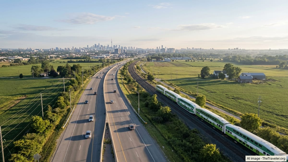
Most visitors travel within the southern band of the province, where Toronto, Ottawa, Kingston, Niagara, London and Windsor are connected by a dense highway grid and several important rail lines. Here, it is realistic to combine driving with commuter and intercity trains, using park-and-ride lots or downtown stations as anchors. Travel times are generally predictable, though peak-hour congestion around Toronto can be significant.
Beyond this southern belt, a different scale applies. Once you head north toward Muskoka, Sudbury, North Bay, Sault Ste. Marie, Thunder Bay or Timmins, distances between services grow longer and public transport thins out. Highway driving remains the primary mode in these regions, supplemented in some corridors by long-distance buses and Ontario Northland’s passenger rail services. Travelers should expect fewer train departures and more emphasis on careful route planning and fuel stops.
For many trips, the most efficient strategy is to blend modes. You might drive to a regional hub with good rail connections, leave the car at a station, and continue into a downtown core by train or urban rapid transit. Thinking in terms of hubs and corridors rather than point-to-point lines will make it much easier to match your itinerary to the province’s transportation reality.
Driving Ontario: Major Highways and Scenic Routes
Driving offers the greatest flexibility for exploring Ontario, especially if your plans include cottage country, provincial parks or smaller communities. The backbone of the provincial road network in the south is Highway 401, which runs roughly east to west from the Quebec border through Cornwall, Kingston and the Greater Toronto Area toward London and Windsor. It is one of the busiest highways in North America, with multiple lanes, frequent service areas and extensive signage. It is efficient but rarely scenic, and traffic can be heavy around Toronto and other major centers.
For a more relaxed alternative along parts of the same corridor, many drivers opt for parallel routes such as Highway 2 in eastern Ontario or regional roads along the north shore of Lake Ontario. Between Toronto and Niagara, the Queen Elizabeth Way links the city to Hamilton, St. Catharines and Niagara Falls. Portions of this drive offer glimpses of Lake Ontario and the Niagara Escarpment, though it is still a fast-moving freeway rather than a leisurely touring route. Drivers heading to cottage country commonly use Highway 400 north from Toronto toward Barrie and Muskoka, then branch off on secondary highways to reach lakeside towns and parks.
Some of Ontario’s most rewarding drives follow the Trans-Canada Highway system. West from Sudbury or Sault Ste. Marie toward Thunder Bay, the route hugs sections of the Lake Superior shoreline, with dramatic views, steep rock cuts and long stretches between towns. In poor weather or in winter, conditions here can change quickly, so travelers should check forecasts and allow extra time. Another classic route follows Highway 11 and Highway 17 in northern Ontario, connecting communities such as North Bay, Temiskaming Shores, Cochrane and beyond. Fuel, food and accommodation are generally available in each town, but it is wise to top up regularly.
Urban driving has its own character. In Toronto, a grid of arterial roads intersects with expressways and collectors that funnel traffic toward downtown and outlying suburbs. Paid parking is common in city centers, and garages can fill quickly near entertainment districts or major events. In Ottawa and other mid-sized cities, drivers will find more manageable congestion, but rush hours still affect key corridors. Wherever you are, remember that winter can significantly extend driving times. Snow, ice and reduced visibility are normal seasonal realities, and rental cars may require winter tires depending on timing and region.
GO Transit and Regional Rail Around the Greater Golden Horseshoe
For anyone staying in or near the Greater Toronto and Hamilton Area, regional rail is one of the most efficient ways to move between suburbs and downtown Toronto. GO Transit operates a network of commuter rail lines radiating from Union Station, including key routes such as Lakeshore West and Lakeshore East, which connect Toronto with communities along the Lake Ontario shoreline toward Hamilton, Niagara, Oshawa and beyond. These lines run frequent service on weekdays, with growing off-peak and weekend options on several corridors.
Many GO stations are designed for park-and-ride use, with large parking lots or structures that allow you to leave your car and continue by train. This can dramatically cut driving time in and out of Toronto’s core and avoid the stress of urban traffic and parking. Some stations also connect with local transit agencies, making it straightforward to transfer to buses or light rail lines. New and upgraded stations, such as additional stops on the Lakeshore corridors and expanded facilities in Hamilton and Niagara, reflect the steady shift toward regional rail commuting and leisure travel.
Service patterns do vary by line and time of day, so travelers should check schedules rather than assume metro-style frequency everywhere. Peak periods typically see the densest train service, while some routes rely more on GO buses outside rush hours. Even then, combining a short drive to a GO station with a rail trip into Toronto is often faster and more predictable than attempting the entire journey by car, particularly on weekdays when highways are crowded.
Regional rail is also a good option for day trips. Visitors can ride to lakeside towns, explore downtown districts on foot, then return by train in the evening. Because GO Transit continues to expand and refine its network, including upgrades to tracks, signals and stations, travelers benefit from gradually shorter journey times and improved comfort without needing to navigate unfamiliar urban streets.
VIA Rail and Long-Distance Passenger Trains
Beyond commuter services, VIA Rail provides the backbone of intercity passenger rail in Ontario, linking major cities and offering long-distance journeys that cross provincial boundaries. The most heavily used routes pass through the Quebec City–Windsor corridor, connecting Toronto with Ottawa, Montreal and smaller centers such as Kingston, Belleville and London. For many travelers, these trains offer a comfortable alternative to both driving and flying, particularly in winter or during holiday periods when roads and airports are crowded.
VIA Rail trains in this corridor typically feature reserved seating, onboard Wi-Fi in select classes, and food and beverage options. Journey times between Toronto and Ottawa or Montreal are competitive with driving once you factor in traffic and rest stops, and arriving at a downtown station can be more convenient than reaching an airport located on the urban fringe. Rail travel also allows passengers to work, read or simply watch the scenery, turning what might be a stressful drive into a more relaxed experience.
Ontario is also crossed by longer transcontinental routes linking eastern and western Canada. While these trains are less about everyday transport and more about the journey itself, they highlight the sheer scale and diversity of the province as they pass through northern forests, lakes and small communities. Departures are less frequent, and schedules may be affected by freight traffic on shared tracks, so travelers should allow for some flexibility when planning connections.
Rail investment is ongoing, with projects intended to gradually improve travel times and reliability on key corridors. Travelers who last used VIA Rail several years ago are likely to find updated rolling stock, refurbished stations in many locations and upgraded track segments that reduce delays. Where rail is available between your origin and destination, it is worth comparing total trip times and costs against driving, especially if you value a lower-stress journey.
Ontario Northland, the Northlander and Remote Rail Links
In northern and northeastern Ontario, Ontario Northland plays a crucial role in both passenger and freight movement. Its services help connect communities that are far from major highways, providing residents and visitors with alternatives to long drives through sparsely populated regions. One signature passenger service is the Polar Bear Express between Cochrane and Moosonee, an all-season link to the James Bay coast that is especially important for local residents and for travelers heading to remote lodges or river trips.
A major current focus is the restoration of the Northlander passenger service between Toronto and Timmins, with a rail connection to Cochrane. Provincial and agency announcements in early 2026 describe construction as nearing completion, with work along the corridor including new warning systems, upgraded signage and enhanced safety at rail crossings. This project is intended to reduce travel times to northern communities and to provide a smoother, more comfortable alternative to long-distance driving or bus travel over hundreds of kilometers.
Even before the full return of the Northlander, Ontario Northland’s wider network remains important. The organization operates motor coach routes that connect northern towns with each other and with larger centers, often in coordination with its rail operations. Travelers using these services should pay close attention to seasonal advisories, since winter storms and other weather events can delay or temporarily halt buses and trains in the interest of safety. Flexibility in itineraries and a willingness to build in buffer time are essential when relying on long-distance ground transport in northern Ontario.
For visitors, combining Ontario Northland services with driving can open up ambitious loops that would be exhausting by car alone. You might, for instance, drive to North Bay or Cochrane, connect to rail for a leg of the journey, and then resume by road in another community. As the Northlander restoration progresses, these options will only increase, making it easier to experience Ontario’s northern landscapes without having to drive every kilometer yourself.
Urban Rail and Rapid Transit in Major Cities
Within Ontario’s largest cities, rail and rapid transit are increasingly central to getting around without a car. Toronto’s subway and light rail network is expanding, with new lines and extensions intended to relieve pressure on crowded bus corridors and to serve fast-growing neighborhoods. Projects such as the Ontario Line and the Finch West light rail line reflect a broader shift toward high-capacity urban transit that connects seamlessly with regional rail at major hubs like Union Station and key GO stations.
As new lines open or move closer to completion, travelers benefit from more direct routes between downtown cores, employment districts, campuses and residential areas. In Toronto, for example, surface light rail corridors and bus rapid transit routes increasingly feed into subway stations, allowing people arriving by regional train or intercity rail to navigate the city using a single fare system or coordinated transfers. This is particularly useful for visitors who prefer to park their vehicle outside the most congested areas and rely on transit once inside the city.
Other municipalities are strengthening their own rapid transit offerings. In the Hamilton area, local plans for rapid bus and light rail corridors aim to reshape how residents connect between neighborhoods and with regional rail stations. In Ottawa, the light rail system has already changed how people move between downtown, residential suburbs and key federal employment hubs, offering an alternative to driving along arterial roads that can be slow during rush hour. These and other projects take time to fully implement, but even partial openings often provide practical options for travelers who would rather not depend on a car once they reach the city.
Visitors should be aware that urban transit networks can be heavily used at peak times, and that construction stages may mean temporary service changes or bus substitutions. Checking for current updates just before travel can help you avoid surprises. Still, for moving efficiently within cities, especially for sightseeing or business meetings across multiple districts, rail-based transit generally provides a faster and more predictable experience than driving in unfamiliar urban traffic.
Planning Safe, Seasonal and Sustainable Journeys
Regardless of whether you choose to drive, ride the rails or combine both, Ontario’s climate and seasonal rhythms should shape your plans. Winters can be harsh throughout the province, with snow, ice and limited daylight. Highway conditions in northern and rural areas can change rapidly during storms, and even major routes in the south may experience reduced visibility, black ice or snow-packed surfaces. Travelers who are not used to winter driving should consider timing trips for late spring, summer or early autumn, or rely more heavily on rail and coach services during colder months.
In peak summer, by contrast, traffic volumes rise on popular routes to cottage country, provincial parks and lakeside communities. Highways north of Toronto can be especially busy on summer weekends, and parking fills quickly near popular beaches and trailheads. Traveling on weekdays, departing early in the morning, or coordinating part of your journey by train can make a significant difference. In shoulder seasons such as late September and October, you may find lighter traffic and brilliant fall foliage along many routes, though nights can be cool and some seasonal services begin winding down.
Rail travel offers certain advantages across all seasons. Trains are largely unaffected by highway congestion, and modern rolling stock is designed to operate reliably through varied weather conditions. For those concerned about the environmental impact of travel, rail typically has a smaller per-passenger footprint compared with driving alone. Combining a single rental car shared by several people with rail segments for the longest legs can further reduce both emissions and fatigue, while still giving you flexibility to explore local areas.
Whichever mode you favor, building realistic margins into your schedule is vital. In winter, that might mean an extra day between remote stops or flexible accommodation bookings. In summer, it might mean avoiding overly ambitious plans that require you to cover very long distances in a single day. Thinking in terms of safe, sustainable pacing rather than racing from point to point will make your time in Ontario far more enjoyable.
The Takeaway
Getting around Ontario is about working with the province’s geography rather than against it. In the south, an extensive web of highways and regional rail lines makes it straightforward to move between major cities and smaller communities, particularly if you are willing to combine driving with GO Transit or VIA Rail. Farther north, Ontario Northland’s services and the returning Northlander line add crucial options in territories where distances are long and populations are sparse.
For most travelers, the best approach is a blended one. Use the car where it shines, on scenic loops to lakes and parks or for reaching trailheads and cottages. Turn to rail for predictable, low-stress journeys between major hubs or when winter weather makes driving less appealing. Pay attention to seasons, build in flexibility and embrace the idea of hubs and corridors rather than expecting uniform service everywhere.
With thoughtful planning and a clear understanding of your options, Ontario’s size becomes a feature rather than a barrier. Its highways reveal sweeping landscapes and lakeshores, while its rail lines offer a comfortable vantage point on cities, farms and forests. Together, they create a transportation network that can support everything from quick city getaways to ambitious cross-province adventures.
FAQ
Q1. Do I need a car to travel around Ontario, or can I rely on trains?
It depends on your itinerary. In the southern corridor between cities like Toronto, Ottawa, Kingston and Niagara, you can rely heavily on GO Transit and VIA Rail. If you plan to visit smaller towns, parks or northern regions, a car or bus plus occasional rail segments becomes more practical.
Q2. How safe is winter driving on Ontario highways for visitors?
Winter highways are well maintained but can still be challenging, especially in storms or on northern routes. If you are unfamiliar with snow and ice, consider rail or coach travel in winter or plan to drive shorter distances with extra time built into your schedule.
Q3. Are there scenic driving routes I should prioritize for a first visit?
Many travelers enjoy the drive along the shores of Lake Superior in northwestern Ontario for dramatic scenery, as well as routes through Muskoka and other cottage country regions north of Toronto. These drives combine lake views, rock cuts and forested landscapes, with plenty of opportunities to stop in small towns.
Q4. How far in advance should I book VIA Rail tickets in Ontario?
For popular routes in the Quebec City–Windsor corridor, it is wise to book at least several days ahead, and earlier during holidays or peak travel periods. Long-distance trains and sleeper services often require more advance planning, as departures are less frequent and certain classes can sell out.
Q5. What is the Northlander and when will it affect my travel options?
The Northlander is a passenger rail service being restored between Toronto and Timmins, with a connection to Cochrane in northeastern Ontario. As construction and corridor upgrades near completion, it is expected to offer a new alternative to long highway drives in that region. Travelers should check for the latest operational start dates when planning.
Q6. Can I combine GO Transit and local city transit on one trip?
Yes. Many GO stations connect directly with city transit systems, making it simple to transfer from a regional train or bus to subways, light rail or local buses. Park-and-ride lots at suburban stations make this particularly convenient if you prefer not to drive into downtown areas.
Q7. Is rail travel in Ontario accessible for travelers with mobility challenges?
Accessibility has improved significantly across both intercity and regional rail in Ontario, with many stations offering elevators, ramps, accessible washrooms and level boarding where possible. Rolling stock increasingly includes accessible seating areas and washrooms. Travelers with specific needs should still review station details and notify operators in advance when possible.
Q8. How expensive is rail compared with driving in Ontario?
Costs vary by route, class of service, fuel prices and whether you are sharing a car. For solo travelers, rail can be competitive or even cheaper once you factor in parking, tolls where applicable and the value of your time. For groups, splitting the cost of a rental car may be more economical for certain legs, especially outside the main rail corridors.
Q9. Are there luggage limits on Ontario trains?
Most passenger rail services in Ontario allow at least one small carry-on and a larger bag, with additional items subject to size and weight guidelines. Some routes and classes offer more generous allowances. It is best to travel with manageable luggage, as you may need to move bags through stations and on and off trains without assistance.
Q10. How far in advance should I check for service changes or disruptions?
Check for service updates in the 24 hours before travel, and again on the day of departure if possible. Weather, construction or operational issues can affect both rail and bus services, especially in winter or during major infrastructure projects. Staying informed allows you to adjust plans or leave earlier if necessary.