


Sedona’s red-rock cliffs, sculpted spires and deep canyons make it one of the most dramatic landscapes in the American Southwest, but its popularity also creates real challenges with parking, crowds and costs. This guide explains how to see Sedona’s best scenery while making informed decisions about hiking difficulty, transportation options, weather risks and what you will realistically spend.
Get the latest updates straight to your inbox!
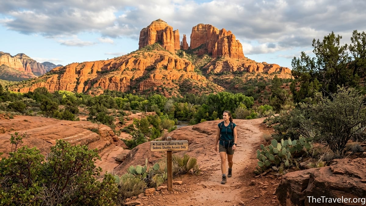
Where Sedona Is, Why It Matters and How Long to Stay
Sedona sits in north-central Arizona, roughly midway between Phoenix and the Grand Canyon. It lies along State Route 89A and State Route 179, surrounded by Coconino National Forest. Phoenix Sky Harbor International Airport is about a two-hour drive in good traffic, Flagstaff is about 45 minutes to the north, and the South Rim of Grand Canyon National Park is roughly two and a half hours away by car. Sedona is compact, but its trailheads, scenic loops and neighboring communities spread out along several highways, so visitors quickly discover that distances and travel times feel longer than they look on a map.
The landscape is defined by vivid red and orange sandstone, eroded into buttes, spires and mesas. Iconic formations such as Cathedral Rock, Bell Rock and Courthouse Butte rise steeply from the valley floor, while Oak Creek Canyon cuts a cool, forested corridor to the north. Compared with the Grand Canyon, which is a vast single chasm, Sedona delivers a more intimate experience with cliffs and towers at eye level and dozens of trails that climb onto slickrock benches. Against Utah’s Zion National Park, Sedona feels lower in elevation and more road accessible, but the trails are often steeper from the start and more intertwined with residential areas.
For most travelers, two full days in Sedona is the minimum to justify the drive from Phoenix. That allows time for one classic sunrise or sunset hike, a scenic drive and half a day exploring galleries and viewpoints. Three days is enough for two or three moderate hikes and a side trip to nearby Cottonwood or Jerome. A five-day stay works well for hikers who want to explore longer routes such as Boynton Canyon or West Fork Trail without rushing, and for those who want flexibility to avoid hot afternoons, icy mornings or monsoon storms.
Visitors deciding between Sedona, the Grand Canyon and Zion should think about priorities. Sedona is easiest for combining day hikes, restaurant evenings and spa hotels. The Grand Canyon is about experiencing a world-class geologic feature, often from the rim with one big hike. Zion is stronger for river hiking and towering canyon walls. Many travelers pair Sedona with the Grand Canyon over four to six days, using Sedona for hikes and relaxation before or after a single long day at the canyon.
Understanding Sedona’s Hiking Terrain and How to Choose Trails
Sedona’s trails vary from flat creekside walks to steep slickrock climbs with hands-on scrambling. Elevations range from roughly 4,000 to 5,000 feet, which is high enough that some visitors feel short of breath, especially on warm days. Trails are often fully exposed to the sun, and many climb quickly from the trailhead without much shade. When choosing routes, focus on distance, elevation gain, exposure to drop-offs, need for scrambling and your timing rather than only chasing the most photographed views.
A short trail does not necessarily mean an easy outing. Cathedral Rock, for example, is often listed at about 1.2 miles round trip with around 600 feet of elevation gain, yet much of that gain comes through steep slickrock where you will use your hands. Local hiking guides describe sections of genuine scrambling and note that some people turn around before the saddle because of exposure and fear of heights. In contrast, Bell Rock has several options that allow less experienced hikers to stay on wide, gently inclined paths around the base while stronger hikers climb higher onto the formation.
Season and time of day matter as much as the mileage. Summer afternoons can exceed 95 degrees Fahrenheit in exposed areas, making morning starts before 7 a.m. advisable for strenuous hikes. During winter, overnight freezes leave ice on shaded slickrock, especially on north-facing slopes and in canyons, so later starts may be safer. During the late-summer monsoon season, usually July through early September, thunderstorms can build rapidly, and local agencies warn that even light rain can lead to flash floods in slot-like drainages.
Realistic times help avoid rushed descents in the dark. A fit, experienced hiker might complete Cathedral Rock in 60 to 90 minutes, but many visitors take two hours or more with rests and photos. West Fork Trail, listed at roughly 6 to 7 miles out and back depending on turn-around, is mostly gentle but involves multiple creek crossings. Families often find that it takes three to four hours, especially when children play in the water or stop frequently.
Key Sedona Hikes by Difficulty, Exposure and Access
Cathedral Rock is one of Sedona’s most famous hikes and a good example of how short can still be demanding. The trail climbs quickly from the trailhead to a saddle with sweeping views and a well-known “photo ledge.” Expect hands-on sections, narrow steps carved in the rock, and potential rockfall from hikers above. The route is unsuitable for those uncomfortable with heights or unstable on steep rock. City and forest information emphasize staying on marked routes to reduce erosion and avoiding hiking beneath other groups in steeper sections. From March into late fall, trailhead parking is restricted and accessed by the free Sedona Shuttle, which removes the option to arrive at dawn in a private car on many days.
Bell Rock and Courthouse Butte provide more flexible options. From the large parking and shuttle-served areas along State Route 179, visitors can walk a nearly level path around the base of both formations or choose signed routes that climb gradually onto Bell Rock itself. The lower loops are suitable for cautious walkers in sturdy shoes, with modest elevation gain and wide tread. Climbing higher becomes progressively steeper and more exposed, though it stops short of the scrambling found on Cathedral Rock. The area works well for mixed-ability groups, as some can rest on benches of slickrock while others explore short side paths.
Devil’s Bridge is another heavily promoted hike that requires honest assessment. The natural sandstone arch is large and photogenic, but reaching it now typically involves combining the Sedona Shuttle, a roadside parking area and a walk on a rutted access road if you do not have a high-clearance vehicle. Many recent trip reports describe a total distance closer to 4 miles or more depending on where you start, with steady climbing toward the end and short exposed steps as you approach the arch. Long lines often form for photos on the bridge, so hikers should budget extra time or be prepared to skip the queue and enjoy the views from nearby viewpoints instead.
Boynton Canyon offers a moderate to long outing with less exposure. The trail begins in a resort-adjacent neighborhood, passes through mixed forest and manzanita, and gradually climbs into a high-walled canyon. Elevation gain is moderate, and while there are some rocky sections, there is no scrambling for those who stay on the main path. A signed side trail leads to a popular “subway” style alcove on a ledge, which involves steeper, narrower footing that some visitors find challenging. Farther north, West Fork Trail in Oak Creek Canyon provides cooler conditions and riparian scenery, with frequent creek crossings on stepping stones or in shallow water. It is generally considered one of the most family-friendly moderate hikes in the region, though it can be very busy in spring and fall and charges a separate day-use fee at the trailhead lot.
Current Transportation, Sedona Shuttle and Trailhead Access
Traffic and parking are among the biggest surprises for first-time Sedona visitors. The city operates the Sedona Shuttle system, a free bus network aimed at trailheads where congestion and illegal roadside parking had become severe. As of late 2026, official information shows three primary trailhead routes in operation, serving Cathedral Rock and Little Horse, Soldier Pass, and Dry Creek and Mescal trailheads, with park-and-ride lots in west Sedona. These routes generally run on selected days of the week, with extended hours during peak seasons and no fare required.
On days when Sedona Shuttle is operating to a given trailhead, parking lots at destinations such as Cathedral Rock, Soldier Pass and parts of the Dry Creek corridor are closed to private cars. This means visitors must plan their day around shuttle timetables rather than assuming they can simply drive to the trailhead at sunrise. For example, current rider guides indicate that shuttle services typically begin in the early morning and run into the evening, with specific holidays such as Thanksgiving listed as no-service days. Travelers visiting during shoulder seasons should confirm which routes operate on their exact dates because schedules can shift between winter and spring or fall and summer.
Beyond the dedicated Sedona Shuttle, the Verde Shuttle and Verde Lynx routes connect Sedona with nearby Cottonwood. Current rider guides show service starting around 6 a.m. and running into the evening, with stops in West Sedona, Uptown Sedona, Tlaquepaque and South Sedona and fares advertised at around 1 US dollar per ride within the local zone. This regional bus connection allows budget travelers to base themselves in Cottonwood, ride into Sedona for the day and transfer to local shuttle services for certain trailheads, though timing and waiting between services need to be built into itineraries.
Travelers arriving without a car can reach Sedona from Phoenix primarily by private shuttle companies and rental cars. Groome Transportation, for example, runs scheduled shuttles between Phoenix Sky Harbor Airport and Sedona with multiple departures daily and per-person fares that, as of 2026, are often in the range of several dozen dollars plus a small fuel surcharge. Phoenix Sky Harbor’s official information lists several intercity shuttle operators that serve Sedona and other northern Arizona towns. There is no single public transit route that runs directly from Phoenix city buses or light rail into Sedona, so visitors who do not want to rent a car must budget both time and money for these intercity services.
Passes, Parking, Permits and the True Cost of Access
Because most of Sedona’s trails sit on U.S. Forest Service land, parking and access are governed by a mix of federal and local fee systems. The Red Rock Pass is a key piece of this puzzle. The Sedona Chamber of Commerce and Forest Service guidance explain that vehicles parked on national forest land in the designated red rock district must display a valid Red Rock Pass or equivalent, or risk receiving a citation. Passes are sold as daily, weekly and annual versions at machines located at many trailheads, at the Red Rock Ranger District Visitor Center and at some local retailers.
In addition to the local pass, holders of national passes such as America the Beautiful Interagency Annual Pass often find that those federal passes cover parking at many Sedona-area trailheads, though not at state parks or some special day-use sites. Recent visitor reports and official recreation guides point out that locations like West Fork of Oak Creek, Grasshopper Point, Crescent Moon and Slide Rock State Park operate their own day-use fees rather than honoring the Red Rock Pass alone. It is important to read signage at each lot, as some locations require payment per vehicle at a staffed booth, while others rely on a displayed pass.
Parking fees and passes contribute significantly to the real cost of a visit, especially for families. A couple staying four nights might purchase a weekly Red Rock Pass if their national pass does not apply, pay a separate entrance fee for a day at West Fork Trail, and potentially another fee for a visit to Slide Rock State Park in summer. If they park in Uptown Sedona’s municipal lots or private garages, they may also encounter hourly metered rates after a grace period, adding several dollars for an evening stroll and dinner.
Besides parking and passes, visitors should budget for tours, equipment and potential resort or parking fees at their lodging. Jeep tours that explore rougher back roads often price per seat, with popular operators charging from under 100 to over 150 dollars per person for two to three hours depending on route and time of day. Scenic flights and hot air balloon rides cost substantially more. Some larger hotels in West Sedona or near Oak Creek report nightly resort fees that can add a significant percentage to the advertised room rate, particularly during spring and fall school holidays.
Experiencing Sedona Without Strenuous Hiking
Not every traveler comes to Sedona to scramble up steep rock. Fortunately, the region offers a strong mix of scenic drives and accessible viewpoints. The Red Rock Scenic Byway along State Route 179 delivers classic views of Bell Rock, Courthouse Butte and Cathedral Rock directly from paved pullouts, with short, mostly level walks to viewpoints. The Upper and Lower Red Rock Loop roads provide different angles on Cathedral Rock and the surrounding cliffs, with picnic areas and riverside parks such as Crescent Moon where many visitors simply sit by Oak Creek, photograph reflections and enjoy sunset.
Within town, Airport Mesa is a favored accessible viewpoint. A paved road climbs from the main highway system to a small saddle area with parking for a short viewpoint walk and a nearby restaurant. The official parking lot at Airport Mesa can fill well before sunset, so visitors often plan to arrive at least an hour early or visit in the morning. The roadside overlook delivers a wide panorama of Sedona’s red-rock amphitheater without the need for a long hike, though cautious footing is still required on uneven rock near the edge.
Cultural and shopping experiences are centered on Uptown Sedona, the galleries along State Route 179, and the Tlaquepaque Arts and Shopping Village. Tlaquepaque is a complex of courtyards, fountains and galleries built in a style inspired by Mexican villages, with stone archways, balconies and shaded passages. Visitors who are not hiking can easily spend several hours browsing art, ceramics, jewelry and local crafts, then lingering over coffee or dinner. Along the same corridor, numerous independent galleries and studios present Southwestern painting, sculpture and photography, some of which feature Sedona’s landscape in all seasons.
The Chapel of the Holy Cross offers another quintessential non-strenuous outing. Built into a red-rock ridge above State Route 179, the chapel is reached via a short walk from terraced parking areas, with shuttle carts sometimes available for those with mobility issues during busy times. Inside, visitors find a modernist sanctuary with a large cross-shaped window framing the cliffs. For those preferring guided exploration, Jeep tours and other off-road excursions visit viewpoints and historic sites, including routes into Dry Creek Basin or along Schnebly Hill Road when conditions allow. Travelers should evaluate these carefully for driving time, ride comfort and environmental impact, choosing operators who avoid sensitive off-trail areas and follow Leave No Trace principles.
Where to Stay and How Sedona Compares with Nearby Towns
Sedona’s compact layout hides big differences between its neighborhoods. Uptown Sedona, clustered along the northern end of State Route 89A, is the main tourist strip with walkable access to souvenir shops, restaurants and several galleries. Hotels here often market direct red-rock views and convenient access to shuttle stops, and room rates reflect that demand, especially around spring break, Easter, fall foliage in Oak Creek Canyon and long weekends. Parking can be tight, and many visitors either pay for hotel parking or rely on public lots that may fill by midday.
West Sedona, stretching along 89A to the southwest, feels more like a small town with supermarkets, gas stations, local restaurants and midrange chain hotels. Room rates are often somewhat lower than in Uptown, and parking is usually easier, but you will need to drive or ride a bus to most viewpoints. For visitors who prioritize affordability and access to everyday services like grocery stores or laundromats, West Sedona can be a practical base. Several of the Sedona Shuttle park-and-ride lots are located in or near this corridor, which can simplify early morning access to trailheads on shuttle-operating days.
The Village of Oak Creek lies a short drive south along State Route 179. It offers a cluster of hotels, vacation rentals and golf resorts with views of Bell Rock and Courthouse Butte, along with restaurants and a few shopping plazas. Prices here can be slightly lower than Uptown during peak times, though some resort properties command high rates year-round. The village location works well for travelers focused on the trails and viewpoints along the 179 corridor, including Bell Rock, Courthouse Butte and the Chapel of the Holy Cross, but reaching Oak Creek Canyon or West Sedona restaurants will take additional driving.
For travelers balancing cost with convenience, nearby Cottonwood and the Verde Valley present strong alternatives. Cottonwood’s historic Old Town and surrounding motels usually price rooms lower than Sedona’s core, partly because they lack direct red-rock views. With the Verde Shuttle connecting Cottonwood to Sedona throughout the day, visitors can base themselves in Cottonwood, ride into Sedona in the morning and return in the evening, saving significantly on lodging while accepting longer daily commutes. This arrangement suits budget-conscious couples and families who prioritize having a kitchen or larger space over being walking distance from Sedona’s shops.
Weather, Safety, Accessibility and Responsible Recreation
Sedona’s climate has distinct seasons that strongly affect hiking and sightseeing plans. Spring and autumn bring comfortable daytime highs and cooler nights, making them the busiest times for trail use and hotel bookings. Parking lots can fill early, and shuttle buses may operate at maximum capacity. Summer brings higher temperatures, often reaching into the 90s Fahrenheit at lower elevations, and the region experiences a monsoon pattern in late summer with thunderstorms that can build quickly in the afternoon. Local safety guidance emphasizes that even light rain can turn narrow drainages into flash floods and that lightning is a serious hazard on exposed ridges.
Winter days are typically cool with cold nights, and snow occasionally dusts the higher formations. While snow usually melts quickly on sun-exposed faces, shaded sections of trail and slickrock can remain icy for days, especially on routes like Cathedral Rock or shaded parts of Boynton Canyon. Hikers should carry traction devices if conditions are icy, and those unaccustomed to cold-weather hiking may prefer mid-morning starts when temperatures have risen and shaded patches are easier to see.
Accessibility varies widely across Sedona’s attractions. Some roadside viewpoints, sections of the Red Rock Scenic Byway pullouts and parts of Tlaquepaque have paved paths or gently sloping surfaces suitable for many wheelchairs and mobility aids. However, most natural-surface trails are rocky and uneven, and even short routes can have steps or roots. Visitors with limited mobility often focus on scenic drives, chapel visits, shorter paved paths and carefully chosen pullouts rather than attempting to reach famous saddles or arches. Airport Mesa’s viewpoint, some spots along Red Rock Loop Road and the lower areas of Crescent Moon and Red Rock State Park can provide satisfying views without long hikes.
Responsible recreation is essential in such a heavily visited landscape. Local agencies and outdoor groups promote Leave No Trace principles, including staying on established trails to prevent erosion of cryptobiotic soils, packing out all trash, keeping dogs leashed where required and yielding space on narrow routes. Wildlife encounters generally involve birds, lizards and small mammals, although rattlesnakes live in the region and may be seen near rocks or shrubs in warm months. Feeding wildlife is discouraged both for animal safety and to avoid habituation. Fire restrictions are common during dry periods, with bans on campfires and sometimes even on certain types of stoves in forest areas. Visitors should check current fire restrictions before planning picnics or backcountry outings.
Practical Itineraries, Costs and Trade-offs
For a two-day visit focused on classic views, an early arrival on Day One allows a short afternoon hike such as the base trails around Bell Rock and Courthouse Butte or the Airport Mesa viewpoint before sunset. Day Two might center on a single signature hike such as Cathedral Rock or Devil’s Bridge, accessed via Sedona Shuttle if the operating calendar aligns with your dates. Build in at least 30 minutes before and after the hike for shuttle transfers and time to find parking at the park-and-ride lots. If the main lot is full, travelers can pivot to a different shuttle-served trailhead or choose a viewpoint accessible by car, such as Red Rock Loop Road or the Chapel of the Holy Cross.
A three-day stay works well for a pair of moderate hikes and more cultural time. One sample plan starts with Bell Rock and a chapel visit on Day One, schedules West Fork Trail or Boynton Canyon on Day Two, and reserves Day Three for a Jeep tour or gallery-hopping around Tlaquepaque and Uptown. Families can adjust the hiking portions by turning back early on longer trails and trading afternoon heat for pool time at the hotel. With three days, it becomes more realistic to avoid midday driving on the busiest stretches of State Route 89A and 179, which often slow to a crawl during peak visitor hours.
Over five days, active travelers might plan four hiking mornings and one mostly rest day. For example, they could hike Cathedral Rock and a short side trail on Day One, do West Fork Trail early on Day Two followed by a drive to Jerome or Cottonwood, tackle Boynton Canyon and nearby viewpoints on Day Three, explore a longer loop in the Dry Creek area on Day Four, and reserve Day Five for a scenic drive, chapel visit and final meal in town. On each day, early starts help with both temperatures and parking or shuttle crowds. Backup options could include lower-elevation trails if ice remains on shaded routes, or gallery time and coffee in Uptown if thunderstorms roll in during the afternoon.
Costs for a couple over three nights often include a midrange hotel in West Sedona or the Village of Oak Creek, which can easily run a few hundred dollars per night in spring and fall, plus taxes and potential resort fees. Add in daily meals, where breakfast and coffee might cost around 20 to 30 dollars for two and dinners at sit-down restaurants in Sedona regularly reach 60 to more than 100 dollars for a couple with drinks and tip. Factor in a weekly Red Rock Pass or equivalent, one or two separate day-use fees for sites like West Fork Trail or Slide Rock State Park, gasoline for scenic drives and at least one paid activity such as a Jeep tour. Families will see food and lodging costs scale quickly, though vacation rentals with kitchens in Cottonwood or the Village of Oak Creek can moderate restaurant spending.
It is important to recognize Sedona’s downsides alongside its beauty. Lodging prices are high compared with many towns of similar size, especially during school breaks and fall foliage season. Popular trails can feel crowded, with lines for specific photo spots and limited opportunities for solitude. Parking restrictions and the necessary reliance on shuttles can frustrate visitors who are used to driving directly to trailheads at all hours. The commercialization of vortex tourism, crystal shops and tour marketing can strike some travelers as excessive. Yet for many, the combination of glowing red cliffs at sunrise, the quiet of a side canyon or the sight of Cathedral Rock reflected in Oak Creek justifies the effort. With good planning around hiking difficulty, transportation and costs, visitors can shape a Sedona trip that emphasizes red-rock scenery and meaningful experiences over traffic and stress.