
More news on this day
Coastal neighborhoods and transport corridors in Semarang, the capital of Central Java, are on heightened alert this week as Indonesia’s meteorological agency warns that extreme high tides and intense seasonal rains could trigger disruptive flooding along the north coast of Java, a vital route for domestic and international travelers.
Peak Rainy Season Meets Extreme Tides on Java’s North Coast
The Badan Meteorologi, Klimatologi, dan Geofisika (BMKG) has reiterated that Indonesia remains in the peak of the rainy season through late February, with Central Java among the provinces facing the highest likelihood of heavy downpours. That pattern is colliding with stronger than usual tidal cycles in the Java Sea, raising the risk of so-called rob, or tidal flooding, in low-lying coastal districts of Semarang.
Authorities explain that a combination of monsoonal winds, active atmospheric disturbances and upcoming lunar phases that favor higher sea levels can slow river drainage and push seawater inland. When these forces coincide with intense, short-burst rainstorms, coastal roads, rail lines and neighborhoods around Semarang’s port and industrial belt are especially vulnerable.
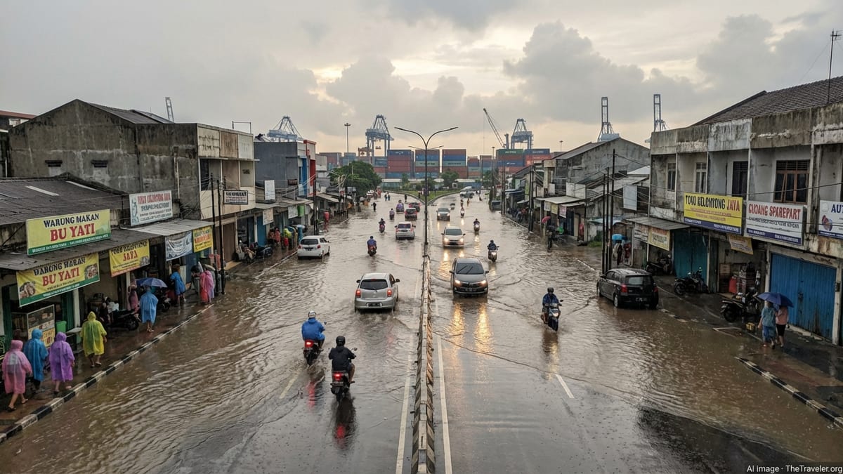
Semarang has dealt with repeated tidal floods in recent years, and images of inundated sections of Jalan Kaligawe Raya and the northern ring road have become familiar during extreme weather. Officials warn that similar conditions are possible again as February gives way to March, and they are urging residents and visitors to monitor evolving forecasts closely.
BMKG’s latest seasonal outlook also highlights the potential for very high rainfall in parts of Central Java into March, even as overall conditions gradually ease later in the month. For travelers, that means local sunshine can quickly give way to torrential showers that coincide with morning high tides, the period when disruptions are most likely.
Semarang’s Most Exposed Districts and Transport Hubs
In Semarang, the areas at greatest immediate risk are the flat coastal zones stretching from the busy port westward and eastward along the main Jakarta–Surabaya corridor. Neighborhoods around Tanjung Emas Port, Genuk, and along the Kaligawe corridor toward Demak have a history of ankle- to waist-deep flooding when tides and river levels peak together.
The north-coast highway that links Semarang with other major Javanese cities, as well as stretches of the parallel railway line, can see water ponding that slows or temporarily blocks traffic. In past events, buses and trucks have been forced to queue for hours or reroute inland, while commuter trains operated with speed restrictions through inundated sections.
Semarang’s Ahmad Yani International Airport is built on reclaimed and low-lying land near the coast, and while protective works have reduced the frequency of flooding, localized standing water on access roads remains a concern during intense storms. Travelers are advised to allow extra time to reach the terminal and to check airline notifications for any weather-related delays.
Within the city, popular waterfront spots and modern retail complexes close to the shoreline can experience access issues if surrounding streets flood, even when the venues themselves remain dry. Tourists staying in seafront or riverside accommodations should confirm that their hotels maintain flood barriers and pumps and have contingency plans for guest movement during peak high tide.
What Travelers Should Expect in the Coming Days
For visitors arriving in Semarang in the last week of February and early March, the most noticeable impact of the current warnings is likely to be on mobility rather than on core tourism sites. Short-term flooding tends to peak in the early morning, between roughly dawn and mid-morning, when high tide combines with overnight rains. Water levels often recede by midday, but traffic backlogs can linger.
Domestic bus and train services along the north coast are expected to continue operating, though schedules may be disrupted if sections of track or roadway are temporarily submerged. Transport operators typically slow trains and divert buses to toll roads farther inland when water levels rise, measures that improve safety but can add significant travel time.
Inside Semarang, ride-hailing drivers and taxis may apply temporary surcharges or take longer detours around flooded streets, particularly in the port-adjacent districts. Travelers aiming to catch early-morning departures should consider booking vehicles earlier than usual and allowing a generous buffer between their hotel and onward connections.
Many inland attractions, including Semarang’s historic Kota Lama, Sam Poo Kong Temple and the highland areas south of the city, sit above the zones most exposed to tidal flooding. However, heavy rain can still cause slick cobblestones, localized pooling and the occasional landslip on mountain roads, so sturdy footwear and flexible day plans remain advisable.
Safety Guidance and Practical Tips for Visitors
Local authorities are urging both residents and visitors to treat waterlogged streets with caution. Even shallow tidal flooding can conceal open drains, potholes and strong currents near canal mouths. Travelers are advised to avoid walking through murky water where possible, and to use elevated sidewalks, footbridges or dry detours when navigating affected neighborhoods.
For those who must travel through coastal zones during the warning period, packing lightweight rain layers, quick-drying clothing and waterproof covers for documents and electronics can significantly reduce discomfort. Hotels and guesthouses in Semarang generally keep umbrellas and rubber sandals on hand during the rainy season and can often advise guests on the safest routes to nearby transport hubs.
Public health officials also remind visitors that floodwaters may be contaminated by sewage and industrial runoff. Any cuts or insect bites should be cleaned promptly, and footwear washed after wading. Travelers with mobility issues should coordinate closely with their accommodation and, where possible, schedule outings outside the peak tide window to avoid unexpected obstacles.
Most importantly, tourists should rely on official Indonesian government weather updates and local disaster management announcements rather than social media rumors. Many accommodations and reputable tour operators monitor BMKG bulletins and can relay clear, up-to-date information in Indonesian and sometimes English.
Planning a Trip While Warnings Are in Effect
Despite the latest alerts, Semarang remains accessible, and most flights, trains and intercity buses continue to run. For new bookings in the coming weeks, travel agents recommend choosing flexible fares that allow date or time changes at low cost in case severe flooding temporarily affects key routes along the north coast.
Travelers already holding tickets may wish to adjust their itineraries to avoid tight same-day connections between modes of transport. Allowing at least several hours between a morning arrival and an onward overland journey can provide a buffer if high-tide flooding slows traffic around Semarang or along the route to neighboring cities.
Choosing accommodation slightly inland or on higher ground can reduce the likelihood of direct flooding impacts while still keeping visitors close to Semarang’s cultural and culinary attractions. Many midrange and upscale hotels in the city center have invested in drainage improvements and backup power systems specifically to manage rainy-season disruptions.
Ultimately, while the current pattern of extreme tides and heavy rain presents real challenges for Central Java’s coastal communities, most travelers who stay informed and build flexibility into their plans can continue to visit Semarang safely. The city’s tourism operators have become increasingly adept at working around short-lived floods, ensuring that visitors still experience its blend of Dutch colonial heritage, Javanese culture and vibrant food scene.