
More news on this day
Weather-related ground stops impacting flights into Houston’s two major airports were lifted after intense thunderstorms and tropical moisture swept through southeast Texas, but airlines are still working through a backlog of delays as the city heads into a hotter, storm-prone stretch of the World Cup travel season.
Get the latest news straight to your inbox!
Storms ease, but delays ripple across the network
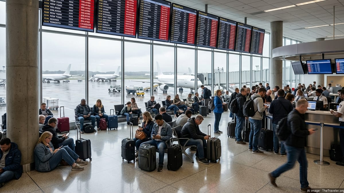
According to published coverage from local media and flight-tracking services, a series of strong storms tied to deep tropical moisture led to temporary ground stops on arrivals into Houston’s George Bush Intercontinental Airport and William P. Hobby Airport earlier this week. The measures paused some inbound traffic while cells capable of producing torrential rain, lightning and low cloud ceilings moved over key approach corridors.
As conditions improved, those weather-related ground stops were lifted, allowing airlines to begin moving aircraft and crews back into position. Flight boards at both airports showed operations gradually stabilizing, although many departures and arrivals continued to run late as carriers repositioned planes and worked through the queue of disrupted flights.
Publicly available data from aviation tracking sites indicates that delays were most concentrated during peak afternoon hours, when storms were strongest and demand from World Cup visitors was high. Some flights were diverted to other Texas hubs during the worst of the weather before being cleared to continue to Houston once the ground restrictions eased.
Travel analysts note that even relatively short ground stops can have outsize impacts in a hub city like Houston. When inbound flights are held elsewhere, aircraft and crews arrive late, which can cascade into missed connections, aircraft swaps and rolling delays that take hours to unwind after the weather has already improved.
What a ground stop means for Houston travelers
A ground stop is a traffic management tool used by aviation authorities to temporarily hold departures bound for a specific airport when conditions there become unsafe or severely constrained. Reference materials point out that these restrictions are often triggered by convective storms, wind shear, hail or other hazards that can make approaches and landings too risky, or sharply reduce the number of planes that can safely land per hour.
For passengers, the practical effect is that flights already on the ground at other airports are not cleared to depart for Houston until the stop is lifted or modified. Aircraft already in the air may be slowed en route, placed into holding patterns or, in more severe cases, diverted to alternate airports. Departures leaving Houston can also be affected if aircraft or crews are stuck elsewhere.
Recent online discussions among travelers highlight some common points of confusion. Many passengers assume a ground stop means all movement at an airport has ceased, when in reality some departures may continue and a limited number of arrivals can still be accepted if conditions allow. Others are surprised to see a stop issued even when skies appear to be clearing, not realizing that constraints along approach paths or in nearby storm cells can still limit capacity.
For visitors routing through Houston during this unsettled stretch of the season, the end of the latest ground stops is welcome news, but the episode is a reminder that schedules remain vulnerable. Industry guidance encourages travelers to build extra connection time into itineraries, monitor their airline’s app or text alerts closely and be prepared for gate or timing changes when severe weather is in the forecast.
World Cup crowds meet an active Gulf weather pattern
The lifting of ground stops comes as Houston manages overlapping pressures from international World Cup traffic and a volatile early-summer pattern in the Gulf. Local forecasts in recent days have featured rounds of heavy rain linked to a tropical system near the Texas coast, followed quickly by a return to oppressive heat and humidity. Coverage from Houston-based outlets describes how potential tropical storm conditions brought flash-flood concerns to coastal areas before the city pivoted back to heat advisories.
Travel-focused weather briefings for World Cup visitors have warned that stormy mornings can give way to dangerously hot afternoons in a matter of hours. That rapid swing complicates airport operations, as ramp crews work around lightning delays followed by heat-related work restrictions, and as passengers move between air-conditioned terminals and outdoor transport links in high humidity.
At George Bush Intercontinental, which serves as the region’s primary long-haul gateway, the combination of weather and event traffic has kept load factors high and turn times tight. Hobby Airport, a major domestic and short-haul international base, has also seen elevated volumes tied to tournament travel and summer holidays. When storms force even temporary reductions in arrival rates, those volumes leave little slack in the system.
Travel industry reports indicate that airlines had already issued flexible travel waivers for Houston on some of the wettest days this week, allowing passengers to shift flights within a limited window without change fees. With ground stops now lifted, those waivers may begin to expire, but carriers are still encouraging travelers to check the status of both inbound and outbound flights before heading to the airport.
Advice for passengers flying through Houston this week
With ground stops lifted but storm threats not completely gone, aviation observers suggest that travelers approach Houston itineraries this week with a mix of flexibility and preparation. Early morning flights often have a better chance of departing on time before daytime heating fuels severe thunderstorms, though overnight storms can still disrupt that pattern.
Passengers connecting through Houston are encouraged to select longer layovers when possible to provide a buffer for weather-driven delays. Those with tight onward connections may want to explore alternative routings through less storm-prone hubs on particularly active days, especially if they are traveling to time-sensitive events or cruises.
On the day of travel, experts routinely recommend checking in early via airline apps, enabling push notifications and reviewing real-time airport status tools that show whether arrival or departure rates are being reduced. If a new round of storms appears in the forecast, travelers may benefit from rebooking sooner rather than waiting until after a fresh set of restrictions is announced and phone and chat queues grow long.
Inside the terminals, passengers should be prepared for busy gate areas as airlines consolidate flights and reaccommodate travelers from earlier cancellations or misconnects. Food, power outlets and seating can quickly become scarce during prolonged disruptions, so packing snacks, a refillable water bottle and a portable charger remains a practical strategy.
Looking ahead to a long, hot travel season
Forecast outlooks suggest that Houston will remain in a classic Gulf Coast summer pattern through the coming weeks, with scattered thunderstorms and the possibility of additional tropical disturbances forming offshore. Local meteorologists have emphasized that even when large-scale systems are not present, fast-developing afternoon storms can still lead to brief but impactful interruptions at area airports.
Airport planning documents for 2026 indicate that infrastructure projects continue around Houston’s primary hub, including work on taxiways and passenger facilities. While those projects are designed to support long-term growth, they can temporarily reduce operational flexibility when severe weather compresses arrival and departure windows.
For now, the immediate pressure of the latest ground stops has eased, and both Houston airports are functioning without broad traffic management restrictions. However, the interplay of summer thunderstorms, tropical systems and major-event travel means that conditions can change quickly. Travelers heading to or through the city in the coming days may enjoy smoother journeys than those caught in this week’s storms, but they are likely to keep one eye on the forecast all the same.