
For many long-distance hikers, the choice eventually narrows to two legendary footpaths: the Appalachian Trail in the East and the Pacific Crest Trail in the West. Both promise months of movement, a reset from everyday life and a tight-knit trail community. Yet the experiences could not feel more different. Deciding which one fits you better is less about which trail is "harder" and more about which environment, logistics and culture match who you are right now.
Get the latest updates straight to your inbox!
Meet the Trails: Mileage, States and Seasons
The Appalachian Trail, or AT, runs about 2,190 miles from Springer Mountain in Georgia to Katahdin in Maine, crossing 14 states along the spine of the Appalachian Mountains. Most thru-hikers walk northbound, starting sometime between late February and early April in Georgia and aiming to finish in Maine before winter conditions return to Baxter State Park in early fall. A typical thru-hike takes 5 to 7 months, with many hikers averaging 12 to 18 miles a day, increasing to 20-plus mile days as their fitness improves.
The Pacific Crest Trail, or PCT, is longer and more remote. It stretches roughly 2,650 miles from the Mexican border near Campo, California, to the Canadian border in Washington, passing through California, Oregon and Washington. Many hikers start northbound at the Mexican border between late March and early May to thread a narrow weather window: not so early that the Sierra Nevada is dangerously snowbound, and not so late that they hit heavy snowfall in Washington before finishing. Most thru-hikes take about 4.5 to 6 months.
Seasonality is a major difference. On the AT, you are chasing spring north as trees leaf out, wildflowers bloom and then colors swing toward autumn in New England and Maine. On the PCT, you move from hot, often water-scarce desert in Southern California into snowy high Sierra passes, then into the volcanic peaks and deep forests of Oregon and Washington. If you dream of misty green forests and rain, the AT leans your way. If you picture big western skies, alpine passes and occasional snow travel, the PCT will feel more like your movie.
When comparing time commitments, consider your own life calendar. For example, a teacher who can leave in late May might lean toward a southbound AT hike, beginning in Maine after the snow melts and finishing in Georgia in late fall. A college graduate finishing in May who wants the PCT might need to plan carefully for a June start in Washington going southbound, accepting lingering snow and fire-related detours as part of the deal.
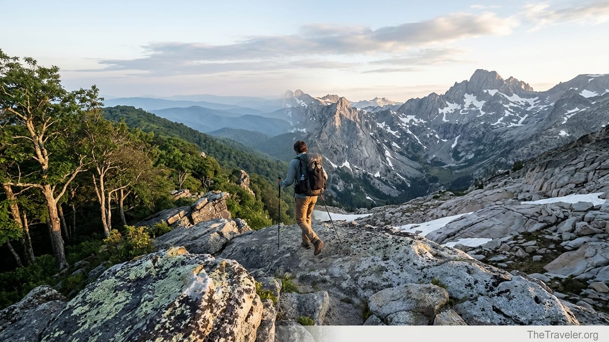
Terrain and Difficulty: Roots vs Exposure
The AT is often described as a “green tunnel.” Much of the trail winds through dense Eastern forest, with roots, rocks and mud as constant companions. Elevation profiles look like sharp teeth: steep climbs and descents packed closely together. In New Hampshire’s White Mountains and Maine’s 100-Mile Wilderness, you may scramble on slick rock slabs and climb using rebar and handholds. Daily elevation gain can feel relentless, even if absolute altitudes remain modest, usually below 7,000 feet. If you have strong legs but little experience at high elevation, the AT’s low altitude is forgiving on lungs but tough on knees and ankles.
The PCT, by contrast, is designed with horses in mind, so the grade is often steadier and more gradual. That does not mean it is easy. You will cross high passes in the Sierra around 11,000 to 13,000 feet and spend long stretches above 8,000 feet. Early in the season, hikers often traverse snowfields and use microspikes or even ice axes for security on slopes. In Southern California, extended ridge walks and exposed traverses mean harsh sun, strong winds and significant temperature swings between day and night.
Exposure is the key word on the PCT. Think of a twenty-mile day across the Hat Creek Rim in Northern California, walking above a lava escarpment with almost no shade in July heat. Water sources might be 15 to 20 miles apart, so you could leave camp carrying 4 to 6 liters of water for the day. On the AT, a comparable twenty-mile day in Virginia might involve frequent shade, multiple springs and shelters, and lower risk of dehydration if you plan normally and filter regularly.
In deciding which fits you better, reflect on where you already hike. If you are used to East Coast trails in places like Shenandoah National Park or the Smokies, and the idea of snow travel and desert navigation feels intimidating, starting with the AT may make more sense. If you are a Colorado or California hiker accustomed to altitude, sun and long, open climbs, the PCT terrain may feel more natural and rewarding.
Trail Culture, Crowds and Town Vibes
Culture on the AT is often described as social, communal and sometimes crowded. The proximity to major Eastern cities means many weekend and section hikers share the path with thru-hikers. In early spring near Georgia, shelters can be full most nights. Trail names are quickly adopted and shared, and it is common to form “tramilies” that hike together from the Smokies all the way to Maine. Trail towns like Damascus in Virginia, Hot Springs in North Carolina and Hanover in New Hampshire have long histories of welcoming hikers, with hostels, gear shops and diners all tuned to the rhythms of the thru-hiking season.
On the PCT, the social scene can be vibrant but is often more spread out. Permit systems limit daily northbound starts at the Mexican border, which keeps crowds more manageable. In the desert section, popular camp spots like Lake Morena or Warner Springs can feel like temporary villages, with hikers cooking on stoves lined up on picnic tables and sharing beta on water sources. Yet by Northern California or Oregon, hikers often stretch out into smaller groups, seeing familiar faces at town stops like Ashland, Bend or Stehekin rather than every night at camp.
Trail towns themselves differ significantly. AT towns are typically older Eastern communities with affordable motels, local diners and traditional outfitters. In 2026, you might pay around 70 to 90 dollars for a basic motel room in a small Virginia town, split between two hikers, and 12 to 15 dollars for a hearty breakfast plate with coffee. PCT towns can skew more expensive, especially in California and destination hubs in Washington and Oregon. A small hotel room in a gateway town near Lake Tahoe can easily exceed 150 dollars in peak summer, while a burger and beer may push 25 dollars in certain resort communities.
If the idea of a strong sense of continuity, with many hikers starting around the same time and repeatedly leapfrogging each other, excites you, the AT will likely feel like home. If you prefer a slightly more dispersed crowd, longer stretches of solitude and a community that clusters more at key resupply points than at every shelter, the PCT may fit your social style.
Logistics, Permits and Resupply
Logistics are one of the biggest practical differences between these two trails. The AT is famous for being relatively straightforward to walk with minimal pre-booking. You do not need a single continuous long-distance permit for most of the trail, although you will need to follow specific rules and in some cases register or pay small fees in national parks and protected areas. Shelters, typically spaced a day’s hike apart in many sections, simplify planning. You can often decide each afternoon whether to tent at a stealth site, aim for a shelter or push on to a road crossing and hitch into town for a hot meal.
The PCT, in contrast, requires more front-loaded paperwork. The PCT long-distance permit, issued through the Pacific Crest Trail Association in partnership with federal agencies, is the preferred document for a thru-hike covering 500 miles or more. Application windows typically open months before hiking season and daily start numbers at the Mexican border are capped. You may also need a California campfire or stove permit and to pay attention to local regulations in fire-prone seasons. Getting a permit in a popular start window like mid-April often requires being flexible and ready to apply as soon as reservations open.
Resupply is simpler on the AT for most hikers. The trail frequently crosses roads, and small towns sit just a few miles or even a short walk off the trail. Many hikers resupply primarily in local grocery stores, dollar stores and gas stations, buying 3 or 4 days of food at a time. In the mid-Atlantic states, it is common to buy lunch at roadside delis or convenience stores and carry less food overall because options are frequent. Mail drops are used more selectively, perhaps to send specialized gear like winter clothing to a hostel in the White Mountains or to get around limited grocery options in parts of Maine.
On the PCT, resupply requires more deliberate planning. Some stretches of the Sierra and parts of Northern Washington have limited or expensive food options. Many hikers mail boxes ahead to key stops such as Kennedy Meadows, a classic gateway to the Sierra; small resupply points in the Oregon Cascades; and remote outposts in Washington that might only have a small general store. For example, in a tiny resort community where instant noodles can cost more than two dollars a packet and choices are slim, having a prepacked box of familiar meals waiting can save money and stress. Expect to carry 4 to 7 days of food between some PCT resupplies, compared with 3 to 5 days on much of the AT.
Weather, Risk and Safety Considerations
Neither trail is risk-free. On the AT, weather hazards often center on cold, wet conditions and lightning. Early-season hikers in the Southern Appalachians can face sleet and snow at higher elevations, even in March and April. Prolonged rain can soak gear for days, raising the risk of hypothermia. Summer thunderstorms in places like the Roan Highlands or the White Mountains roll in quickly; hikers above treeline need to be ready to descend, avoid ridgelines and seek lower ground.
The PCT adds extremes of heat, cold and wildfire. In Southern California, hikers routinely encounter daytime temperatures above 90 degrees Fahrenheit in exposed desert. It is normal to start hiking by headlamp at 4 a.m., cover most of your miles before noon and rest in shade during the hottest hours. In the Sierra, snow travel and fast, cold stream crossings can be serious hazards in big snow years. Later in the season, wildfire smoke, trail closures and detours have become recurring realities in Oregon and Washington. Hikers should plan mentally and logistically for possible skipped sections or reroutes.
Animal encounters also differ. On the AT, black bears are common in areas like Shenandoah National Park, the Smokies and parts of New Jersey and New York. Many campgrounds now require or strongly recommend bear canisters or bear cables, and food hangs are standard practice. On the PCT, black bears are present, especially in the Sierra and some Cascades regions, and bear canisters are mandatory through popular Sierra wilderness areas. Rattlesnakes are a regular sight in the lower-elevation desert and oak woodlands of California; hikers need to watch foot placement and avoid stepping over logs blindly.
In terms of emergency support, the AT has more frequent road crossings and easier access to trailheads. For instance, in parts of Virginia or Pennsylvania you might intersect a paved road every few miles, making self-evacuation or assistance more feasible. On sections of the PCT in the Sierra or North Cascades, you may be 20 or more miles from the nearest trailhead and another long drive from the nearest town. For solo hikers or those nervous about remoteness, the AT’s denser access grid and more consistent cell coverage can be reassuring. Either way, many thru-hikers now carry satellite communicators to message home and call for help in true emergencies.
Budget, Gear and Physical Preparation
Costs vary widely depending on personal style, but planning rough ranges helps. Recent planning guides suggest a full PCT thru-hike often runs in the neighborhood of 7,000 to 12,000 US dollars, including town food, lodging, resupply shipping and replacement gear, not counting pre-trip purchases of big-ticket items like a tent or backpack. The AT is generally somewhat cheaper thanks to more abundant budget lodging and cheaper resupply in many small Eastern towns. A frugal AT hiker who camps most nights, shares motel rooms, limits restaurant meals and rarely drinks alcohol in town might keep on-trail expenses closer to the mid four figures, while someone who takes frequent zero days in hostels and eats out liberally will spend much more.
Gear lists for the two trails overlap but are not identical. On the AT, a three-season setup with a 20-degree Fahrenheit sleeping bag or quilt, a reliable rain jacket and pants, and trail runners or light boots is standard. Many hikers swap winter gear out in Virginia and then pick it up again before entering the White Mountains and Maine, where nights can turn cold. Trekking poles are almost universal due to constant ups and downs and muddy sections.
The PCT pushes gear into more specialized territory. Desert heat and sun exposure make a sun hoodie, wide-brimmed hat, sunglasses and light-colored clothing important. Water capacity of 4 to 6 liters is common in the desert stretch, and many hikers carry a reflective umbrella for shade. In the Sierra, at least in higher snow years, traction devices such as microspikes, and sometimes an ice axe, are part of many kit lists, alongside a hard-sided bear canister. Footwear tends toward trail runners with good drainage, as hikers may ford icy streams daily during peak snowmelt.
Physical preparation should reflect likely conditions. For an AT attempt, regular stair-climbing, hill repeats and weekend hikes on rocky, rooted trails will prepare your legs and ankles. Doing practice overnights in rainy conditions helps test your shelter and layering systems. For the PCT, adding altitude exposure when possible and practicing travel on snow in controlled settings is wise, whether that means hiking in the mountains in late spring or joining an introductory mountaineering course. Regardless of which trail you choose, starting with a pack weight under 30 pounds including food and water will improve your experience and reduce injury risk.
Which Trail Fits Your Personality and Goals?
Ultimately, the better trail for you depends on your personality, risk tolerance, experience and what this particular year of life represents. If you are seeking a community-heavy experience, with frequent town stops, dense social interaction and a long tradition of trail magic and hiker festivals, the AT will likely tick more boxes. It is an excellent first thru-hike for people who want constant bail-out options, lower elevation and the ability to adapt plans on the fly without extensive pre-booking.
If you crave big landscapes, longer stretches of solitude and are excited rather than intimidated by navigation through varied climates, the PCT may be your match. It often attracts hikers who already have backpacking experience, possibly shorter section hikes on the AT or local trails, and who are ready to learn about snow travel, desert logistics and wildfire contingencies. The permit process and travel distances to remote trailheads can feel more complex, but for many, the payoff is the chance to walk under the granite walls of the Sierra, across the lava flows of Oregon and through the glaciated valleys of the North Cascades in one continuous journey.
Be honest about your comfort zone. For example, if you live on the East Coast, have never seen crampons or an ice axe in person and feel anxious about being far from quick rescue, launching your long-distance hiking life with the AT can build skills more safely. You might later tackle the PCT with a stronger foundation. Conversely, if you live in Seattle, spend weekends in the Cascades and amass winter travel experience each year, the PCT may feel like an exciting extension of the terrain you already love.
Many hikers eventually do both trails, sometimes years apart. There is no wrong answer. A thoughtful choice for your first long trail, matched to your current skills and interests, gives you the best chance of joining the small but growing group who walk from border to border in a single season and still want to hike again when they reach the terminus.
The Takeaway
When you strip away the romanticism and look at real-world details, the Appalachian Trail and the Pacific Crest Trail are two very different adventures. The AT offers dense forest, steep but low-elevation climbs, frequent towns and a famously social culture. The PCT delivers bigger views, more remote stretches, major weather swings and a higher logistical bar, from permits to specialized gear.
If you value accessibility, the ability to improvise, plenty of company and a gentler learning curve for navigation and weather, the AT likely fits you better. If you prefer wide open landscapes, fewer road crossings and are willing to plan carefully for permits, snow and wildfire, the PCT may be the long-distance journey you are really imagining when you picture yourself walking for months on end.
Whichever you choose, start early on physical preparation, budget realistically, research current conditions and closures, and be ready to adapt your expectations. Long-distance hiking is as much about patience and resilience as it is about miles walked. With realistic planning and a trail that matches your personality, either the Appalachian Trail or the Pacific Crest Trail can become the adventure that reshapes how you see yourself and the landscape around you.
FAQ
Q1. Is the Appalachian Trail or the Pacific Crest Trail better for a first thru-hike?
The Appalachian Trail is usually the better first thru-hike for most people because it has more road access, frequent resupply points, lower elevation and simpler permit requirements, which collectively lower the logistical and safety barriers for beginners.
Q2. How long does it typically take to thru-hike the AT vs the PCT?
Most hikers take about 5 to 7 months to complete the Appalachian Trail and roughly 4.5 to 6 months for the Pacific Crest Trail, depending on fitness, weather, injury, and how many rest days they take in town.
Q3. Which trail is more dangerous?
Both trails carry risk, but the PCT generally has more objective hazards like long water carries, high-elevation snow travel and wildfire disruptions, while the AT’s main risks tend to be cold, wet weather, slips and falls on steep terrain and occasional severe storms.
Q4. Do I need special permits to hike these trails?
On the AT, you mostly follow local regulations and pay small park fees where required, but a single long-distance permit is not mandatory. On the PCT, a long-distance permit is strongly recommended for thru-hikers, and there are start-date quotas at the Mexican border plus additional rules such as mandatory bear canisters in parts of the Sierra.
Q5. How much money should I budget for each trail?
Exact costs vary, but many hikers budget several thousand dollars for the Appalachian Trail and somewhere in the mid to high four figures, sometimes more, for the Pacific Crest Trail, accounting for food, town stays, replacement gear, transport and permit-related expenses.
Q6. Can I hike either trail without prior backpacking experience?
Some people start their long-distance hiking careers on these trails, especially on the AT, but it is wise to do at least a few shorter backpacking trips first to test gear, learn basic campcraft and see how your body and mind handle multiple days on trail before committing to a multi-month thru-hike.
Q7. What is the best time of year to start the AT vs the PCT?
Northbound AT hikers commonly start between late February and early April in Georgia to reach Maine before fall conditions close the high country, while northbound PCT hikers usually begin between late March and early May at the Mexican border to balance desert heat, Sierra snow and early snowfall in Washington.
Q8. How do resupply strategies differ between the two trails?
On the AT, you can mostly buy food as you go in towns and rely less on mailed packages because stores are frequent. On the PCT, especially in the Sierra and parts of Oregon and Washington, many hikers rely more on mailed boxes to small outposts and carry larger food loads between resupply points.
Q9. Which trail is better if I prefer solitude?
The PCT generally offers more sustained solitude, especially outside popular starting weeks and in remote sections of the Sierra and Cascades, whereas the AT tends to have more hikers on any given day, especially in spring in the southern states and in iconic sections like the Whites.
Q10. Is it realistic to plan to hike both the AT and the PCT someday?
Yes, many long-distance hikers complete one trail and later return for the other, sometimes years apart. Starting with the trail that best matches your current skills and logistics often increases your chances of success and leaves you excited rather than burned out for a future attempt on the second trail.