
More news on this day
A strengthening Typhoon No. 8 over the Philippine Sea is reviving the risk of a double-storm scenario across parts of East Asia this week, as two tropical systems interact with a stalled seasonal rain front and raise the threat of dangerous flooding and landslides in Japan.
Get the latest news straight to your inbox!
Typhoon No. 8 strengthens, joins Typhoon No. 7 in western Pacific
Publicly available information from regional meteorological agencies indicates that Typhoon No. 8, named Higos in the international naming list, was upgraded from a tropical depression over the Mariana Islands region on June 23. The system has since been tracking northwest across the Philippine Sea, gradually consolidating its core and drawing more moisture from the surrounding warm waters.
Japan-focused broadcast and online coverage reports that Typhoon No. 8 is now one of two organized systems over waters south of Japan, alongside the earlier-forming Typhoon No. 7, Mekkhala. Together they are described as a “double typhoon” pattern, with both storms moving generally northward and feeding humid air toward the Japanese archipelago.
Forecast discussions from multiple international weather centers show Typhoon No. 8 strengthening into at least a strong tropical storm or minimal typhoon as it approaches the latitude of Kyushu and Shikoku late this week. While exact track and intensity remain uncertain, projected paths keep the core of the system over or just east of the main islands, close enough for prolonged periods of heavy rain and gusty winds.
Satellite imagery shared by weather analysis outlets depicts a broad shield of thunderstorms wrapping around the circulation of Typhoon No. 8, with spiraling rainbands already extending hundreds of kilometers to the north and northeast. This structure is expected to expand as the cyclone taps into stronger southwesterly flow ahead of an upper-level trough.
Double-storm setup intensifies Japan’s early-summer rainfall
Japanese media and regional outlooks describe Typhoon No. 8 and Typhoon No. 7 as forming a dangerous pair during the height of the Baiu, or East Asian rainy season. In this period, a semi-stationary seasonal front often stalls over or near Japan for days at a time, providing a focus for repeated downpours even without tropical storms.
With two cyclones now feeding warm, moisture-laden air into the same frontal zone, forecasters warn of a “double-storm” effect on rainfall totals. Analyses suggest that Typhoon No. 8 may first inject a surge of tropical humidity into the Baiu front, followed by a second, potentially stronger pulse associated with Typhoon No. 7 as it curves closer to the archipelago later in the week.
Model guidance summarized by international weather forums points to the possibility of widespread heavy rain from Kyushu through Shikoku and into the Kinki and Kanto regions, including major metropolitan areas. Some ensemble projections highlight localized multi-day rainfall totals that could reach or exceed typical June monthly averages in just a few days.
While there is no certainty that peak winds will be severe far inland, the combination of saturated soils, steep terrain and intensifying tropical rainfall raises the risk that even moderate gusts could trigger falling trees, power interruptions and transport delays along already waterlogged slopes and river valleys.
Flooding and landslide risks rise across Kyushu, Shikoku and Honshu
According to published coverage from Japan-based outlets, hydrological authorities are monitoring rivers across southern and western Japan for rapid rises as the storms approach. Some catchments in Kyushu and Shikoku have already experienced repeated heavy rain events earlier this month, leaving ground conditions primed for rapid runoff.
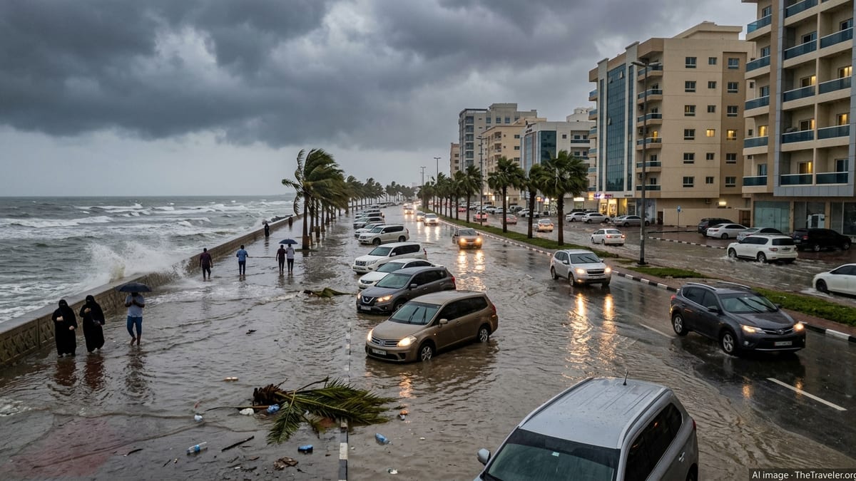
Risk assessments shared by disaster-preparedness organizations emphasize that the most serious hazards from the current double-storm setup are likely to be flash flooding and landslides rather than extreme winds. Narrow valleys, heavily populated coastal plains and hillside communities are particularly vulnerable where intense downpours overlap with high tide cycles.
Urban areas, including cities in northern Kyushu, the Kansai region and the greater Tokyo area, face the possibility of waterlogged underpasses, overwhelmed storm drains and localized surface flooding if persistent rainbands stall overhead. Travel disruptions on rail networks and highways are considered likely in worst-affected corridors, even if the centers of the typhoons remain offshore.
Coastal districts along the Pacific side of Japan may also experience rough seas and strong onshore swells as Typhoon No. 8 tracks nearby. Maritime advisories already highlight hazardous conditions for smaller vessels and elevated surf along exposed shorelines, with additional deterioration expected as the circulation intensifies.
Potential storm interaction adds uncertainty to late-week forecast
Meteorologists tracking the western North Pacific note that the presence of two relatively close tropical cyclones can introduce complex interactions, sometimes referred to as the Fujiwhara effect. In such cases, storms can rotate around a common point, influence one another’s tracks or even merge into a larger system, adding a layer of uncertainty to medium-range forecasts.
Specialist weather analyses suggest that Typhoon No. 8, being the younger and generally weaker of the pair, may become increasingly influenced by the larger circulation of Typhoon No. 7 as the week progresses. This interaction could alter the timing and angle at which each system approaches Japan or curves northeastward into the open Pacific.
Because of these potential interactions, track projections for both storms currently show a spread of possible outcomes, ranging from a closer brush to Kyushu and central Honshu to a more easterly route that would keep the strongest winds offshore while still delivering heavy rain. Forecast maps issued by national and international centers are being updated frequently as new satellite and observational data become available.
For travelers and residents, the changing guidance means that local conditions could shift with relatively short lead time, particularly regarding where the heaviest rainbands set up over the weekend. Authorities in Japan typically refine advisories and evacuation guidance as forecast confidence improves within 24 to 48 hours of expected impact.
Travelers urged to monitor local advisories and be flexible
Travel industry updates and airline notices indicate that the evolving double-storm pattern may disrupt flights and rail services within and to Japan, especially on routes serving Kyushu, Shikoku, Kansai and the Tokyo metropolitan area later this week. Temporary suspensions are common along high-speed rail lines and regional routes when strong winds or heavy rain are expected.
Travelers already in Japan are encouraged by tourism agencies to follow local news, hotel notices and municipal alert systems for information on potential service changes or shelter recommendations. In past seasons, even storms that remained offshore have caused knock-on delays to domestic air and rail timetables, particularly during periods of intense rainfall.
Visitors planning trips in the coming days may wish to allow extra time for connections, consider flexible booking options and prepare for the possibility of last-minute adjustments to itineraries in affected regions. Outdoor activities such as hiking, coastal sightseeing and river excursions are particularly sensitive to fast-changing weather and may need to be postponed or relocated.
Although the precise impact of Typhoon No. 8 and its companion storm is still developing, the emerging picture for late June is one of renewed weather-related disruption potential across parts of Japan. Close monitoring of updated forecasts and readiness to adapt plans remain the most practical steps for travelers navigating the return of a double-storm risk in the western Pacific.