


The Jökulsárgljúfur section of Vatnajökull National Park strings three major waterfalls along a single glacial river: Selfoss upstream, Dettifoss in the middle and Hafragilsfoss downstream on Jökulsá á Fjöllum. Many visitors know Dettifoss, but do not realize how close Selfoss and Hafragilsfoss are, or how straightforward it can be to see all three on one carefully planned outing. This guide focuses on practical itineraries, safety and time budgeting rather than poetic description.
Get the latest updates straight to your inbox!
Understanding Jökulsárgljúfur and the Three Waterfalls
Jökulsárgljúfur is the northern canyon sector of Vatnajökull National Park, running from the Dettifoss area north to Ásbyrgi. The landscape is shaped by the glacial river Jökulsá á Fjöllum, which drains meltwater from the Vatnajökull ice cap and has repeatedly flooded catastrophically in the past. Today the canyon is a core hiking and sightseeing area in North Iceland, with road access on both the west and east sides in summer conditions.
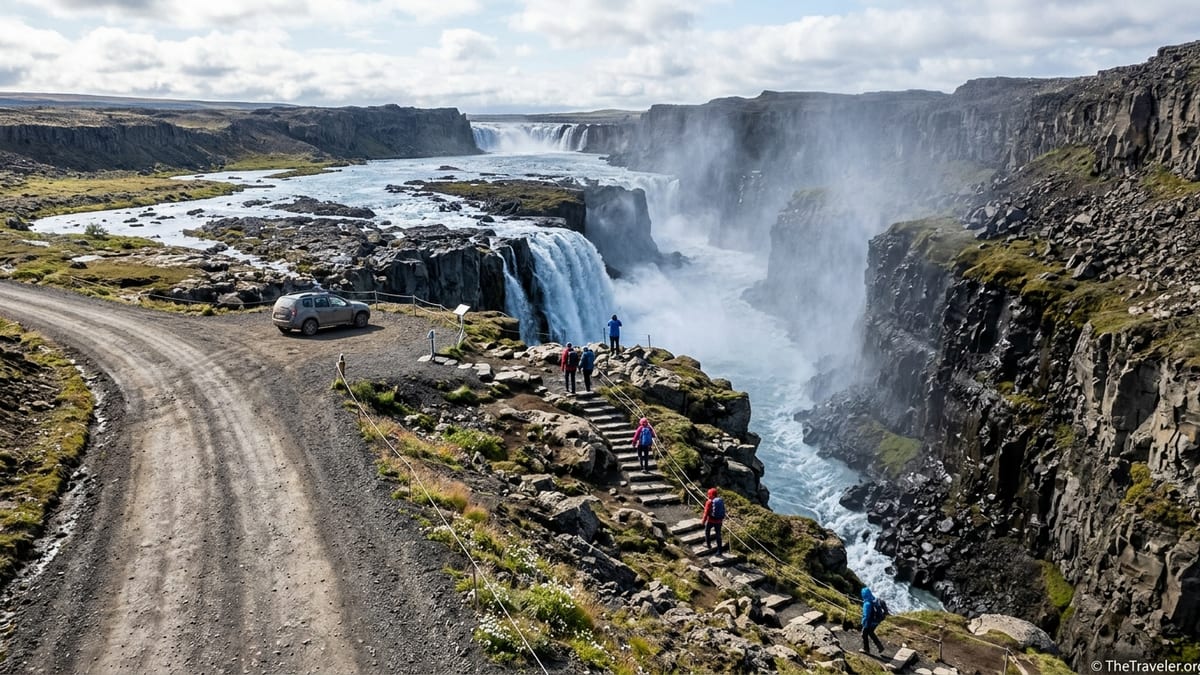
Along a relatively short stretch of this river you find three major waterfalls in sequence. Selfoss lies upstream, spreading the river in a wide, low curtain where it begins to drop into the canyon. A few hundred metres downstream the river plunges over the lip of Dettifoss into a narrower chasm, creating a powerful vertical fall. Farther down the canyon, Hafragilsfoss drops again into a deeper gorge, framed by high walls and more extensive views of the canyon system.
Each waterfall has its own character. Selfoss is lower but broad and elegant, with multiple channels. Dettifoss is taller and more compact, with an immense volume of water and dense spray. Hafragilsfoss is best appreciated from above, where you see the river cutting through the canyon and the fall as part of a wider landscape. Rather than comparing them by superlatives, it is more useful for planning to know how they line up geographically and how the access works from each side of the canyon.
Most visitors will approach from the west on paved Route 862, which serves the main Dettifoss west car park and marked trails to both Dettifoss and Selfoss. In good summer conditions, an older gravel road, Route 864, offers access on the east side, closer to the falls but on a rougher surface. There is no bridge near the falls, so you must choose one side at a time by car.
West Side Basics: Route 862 and the Main Dettifoss Car Park
For most travellers, particularly those driving a standard rental car or visiting outside high summer, the west side on Route 862 is the default choice. The road from the Ring Road near Lake Mývatn to the Dettifoss west car park is paved and generally maintained from late spring through autumn, with winter access depending on weather and snow. The west car park has marked paths, viewing platforms and usually basic facilities such as toilets, but there are no shops or regular food services, so you must arrive self-sufficient.
From the west car park, a well-defined path leads toward Dettifoss. According to current Vatnajökull National Park information, the combined Dettifoss and Selfoss circuit from this car park is approximately 2.5 kilometres, typically taking around one hour at an easy pace in dry summer conditions. Within that loop, the walk from the car park to the main Dettifoss viewpoints is about 1 kilometre one way. These figures are a solid planning baseline, but any writer preparing a guide should reconfirm exact distances and estimated times against the latest official park materials at publication time.
The west-side paths are constructed for heavy visitor use. Expect compacted gravel or rock surfaces, sections of boardwalk or paving near the viewpoints, and some steps and short climbs. The approach involves moderate up and down, but it is not a mountain hike. There are unprotected drops in the vicinity, however, so anyone with vertigo or mobility challenges should be prepared for exposed canyon edges once you leave the main viewpoint platforms.
Conditions can change quickly. Spring snowmelt often leaves sections wet or muddy, and in shoulder seasons ice can linger on shaded parts of the path even when the car park is clear. Strong winds are frequent and can be severe near the lip of the canyon, intensifying the spray from Dettifoss and making rocks slippery. Park authorities occasionally close or reroute parts of the viewing area or specific paths for safety reasons, and recent notices have mentioned permanent closures of some older informal viewpoints near unstable cliffs. Treat any ropes, barriers or closure signs as absolute; do not step over them for a photo.
Walking the Standard West-Side Loop to Dettifoss and Selfoss
The classic west-side itinerary begins at the Dettifoss west car park, where you follow clear signage to the main Dettifoss viewpoints. Allow at least 15 to 20 minutes each way between the car park and the primary Dettifoss viewing platforms in typical summer conditions, longer in wind, snow or ice. The final approaches include steps and short rocky sections, and spray can be intense when the river is high, so waterproof outer layers and secure camera protection are advisable.
After experiencing Dettifoss from the west, you return slightly along the path and follow the marked trail upstream toward Selfoss. On this side, the distance between the Dettifoss area and Selfoss is roughly 600 to 700 metres one way on mostly level terrain, making the combined circuit, including both waterfalls, about 2.5 kilometres. The national park currently describes this route as easy, but that rating assumes dry, snow-free ground and suitable footwear. Future writers should double-check both the official distance and grade rating on the park website or at visitor centres before finalizing printed guidance.
The path to Selfoss on the west involves walking close to the canyon edge in places, although the main route keeps a sensible distance from sheer drops. Surfaces alternate between gravel, bedrock and stones. There are no handrails except at specific viewpoints, and children must be supervised closely. When the river is high, spray can drift upstream and make nearby rocks damp and slick.
Once at Selfoss, you will find viewpoints that look down into the broad curtain of water as it spills into the canyon. The perspective here is more top-down compared to the east side, where visitors get closer to the base. Even so, the combination of Dettifoss and Selfoss in one simple loop from the west car park is one of the most efficient ways to see both falls without tackling rough trails or long driving detours.
Reaching Hafragilsfoss from the West and East
Hafragilsfoss sits downstream from Dettifoss in a deeper part of the canyon, and for most casual visitors it is reached by car from a separate viewpoint parking area, not on foot from Dettifoss. On the west side, Route 862 continues north from the Dettifoss west junction to a signposted turnoff for a Hafragilsfoss viewpoint. From this small parking lot, a short marked path leads to a fenced or otherwise clearly defined viewing area on the canyon rim.
The west-side Hafragilsfoss walk is short, on the order of a few hundred metres, but it crosses uneven ground and leads directly to high, unfenced canyon edges in places. The reward is an expansive view looking up and down the Jökulsárgljúfur canyon, with Hafragilsfoss framed far below and Dettifoss sometimes visible in the distance upstream in clear conditions. Because of the exposure and the lack of built-up walkways, this is not an appropriate viewpoint for anyone uncomfortable near drops or for very young children running free.
On the east side, in good summer conditions when Route 864 is open, a separate unpaved spur and parking area serve another Hafragilsfoss viewpoint. From here, visitors can walk a short distance to the rim for a different angle, typically looking across to the west side and further along the canyon. Surfaces are rougher on this side, and facilities are minimal or nonexistent. As with Dettifoss and Selfoss, it is important to understand that there is no direct crossing of the river near Hafragilsfoss. To compare both viewpoints in one day you must drive a long loop via the Ring Road, which is realistic only with an early start and stable conditions.
Official trail descriptions in this area also mention a longer and more demanding route known as Hafragilsundirlendi, which descends closer to river level on the west side in a challenging loop. This is not a casual add-on to a short sightseeing stop. It requires several hours, good fitness and stable weather, and should only be attempted by well-prepared hikers who have studied up-to-date route descriptions and current conditions from park staff. For a typical visitor focused on seeing all three waterfalls in one outing, the canyon-rim viewpoints reach the goal without that extra commitment.
East Side Option: Route 864 in Good Conditions
Route 864 on the east side of the canyon is an older gravel road that usually opens in summer when snow and mud have receded. It is not routinely maintained to the same standard as the paved west road, and surface quality varies from year to year, with potholes and washboard sections common. Rental companies often allow standard two-wheel-drive cars here in dry conditions, but you must drive slowly, watch for loose gravel and be prepared to turn back if conditions deteriorate. Outside summer, parts of the road are commonly closed, and travellers should check current status shortly before their visit.
In return for the slower approach, the east side offers closer, more frontal views of both Dettifoss and Selfoss. A marked parking area on the east bank provides access to trails that follow the canyon rim toward each waterfall. The paths on this side are generally rougher and more natural than on the west, with more boulder hopping and uneven rock underfoot. Guide descriptions commonly note that the east-side route between Dettifoss and Selfoss can feel more like a short hike than a stroll, and families with small children or anyone unstable on uneven terrain may find it challenging.
Typical planning figures suggest allowing around 1.5 hours for a leisurely visit to Dettifoss and Selfoss combined on the east side, including time to walk between viewpoints and pause for photographs. Distances are modest, but progress is slower due to the rocky surface. As always, writers should confirm exact distances, current path markings and any partial closures with the latest park resources, as informal side tracks to the cliff edge are sometimes closed or rerouted for safety.
Hafragilsfoss can also be viewed from the east in season, but again, the access is via a separate viewpoint area, not an easy rim walk from Dettifoss for casual visitors. If Route 864 and the Hafragilsfoss spur are both open, you can add this stop either before or after visiting Dettifoss and Selfoss. However, combining all three from the east side in a single short outing makes for more driving on gravel and more walking on uneven ground than the equivalent west-side plan, so many visitors still choose to mix sides over different days rather than forcing the issue.
Safety, Rules and Seasonal Conditions
The Jökulsárgljúfur waterfalls are inherently hazardous environments. The canyon edges are high, often unfenced and sometimes undercut. Rocks near the rim can be loose or slick with spray, and in wet or icy conditions even gentle slopes can become treacherous. Strong winds can arrive quickly and push people off balance near drops. You should move cautiously, keep well behind any barriers or ropes and avoid stepping onto overhanging slabs, no matter how tempting the view.
Snow and ice are very likely outside the core summer months, typically late June to early September, and may linger even longer in shaded gullies. Shoulder-season visitors often find that the car park and the first part of the path are clear, while compact ice persists further along the canyon edge. Lightweight traction devices and trekking poles can be valuable in these conditions, but the safest choice is sometimes to accept a partial view rather than forcing your way to every viewpoint.
Vatnajökull National Park sets rules for behaviour in the Jökulsárgljúfur area, which can change over time. As of recent seasons, visitors are expected to stay on marked paths, avoid disturbing vegetation and absolutely not descend unmarked routes toward the river. Drone use is tightly regulated or banned in many national park zones, particularly near busy viewpoints and bird nesting areas, and may require a specific permit if it is allowed at all. Off-trail walking to the very edge of cliffs, constructing cairns or crossing rope barriers is prohibited. Any writer preparing updated guidance should confirm the latest official rules on drones, off-trail access and restricted viewpoints directly with park sources before publication and summarize them clearly for readers.
Weather can deteriorate rapidly even on apparently pleasant days. Fog can roll into the canyon, eliminating depth perception, while rain and wind can reduce visibility at the falls themselves. Mobile phone coverage is variable, and you should not rely on a constant signal for navigation or emergency calls. Inform someone of your plans, be ready to turn back early if conditions worsen and treat local advice from park staff or rangers as definitive.
What to Bring and Accessibility Considerations
Services at Dettifoss, Selfoss and Hafragilsfoss are limited. You should arrive with enough water, snacks or lunch for your planned stay and a fully charged phone. There are usually basic toilets at the main Dettifoss west and east parking areas in season, but you should not count on facilities at every viewpoint, especially at Hafragilsfoss. Rubbish bins may be scarce, so plan to pack out all waste.
Sturdy footwear with good grip is essential. Trails involve rock, gravel and sometimes wet or icy patches, and standard city sneakers can feel insecure on these surfaces. Waterproof footwear or at least quick-drying hiking shoes are strongly recommended. Layered clothing is important as you move between a sheltered car interior, exposed canyon rims and spray-filled viewpoints. Even in mid-summer, wind chill near Dettifoss can be sharp, so bring a warm layer and a windproof or waterproof shell.
Those with reduced mobility should be aware that while some west-side viewpoints near the Dettifoss car park are relatively short walks on improved surfaces, they are not fully step-free or rated as wheelchair-accessible in a reliable way. Expect steps, slopes and uneven ground even on the easier routes. Reaching Selfoss or Hafragilsfoss generally requires additional walking on natural surfaces with stones and occasional drops. Travellers who use mobility aids or who tire easily may choose to prioritize the closest west-side Dettifoss viewpoints and skip the longer loops.
Families with young children should plan extra time, discuss safety clearly before leaving the car and keep children within arm’s reach near any canyon edge. Slippery rocks and sudden gusts of wind are the main risks, along with simple missteps while running or jumping. A change of dry clothing for children can be very welcome after standing in spray or light rain.
Fitting the Falls into Wider Jökulsárgljúfur Hiking
The Dettifoss, Selfoss and Hafragilsfoss area is also the southern anchor of a much longer trekking route through Jökulsárgljúfur. Multi-day hikers commonly follow marked trails between Dettifoss and Ásbyrgi, linking viewpoints, side canyons and other features of the gorge. This through-hike requires careful planning, appropriate equipment and attention to river crossings and shelter options, and is beyond the scope of a simple day-trip guide.
Even for non-trekkers, it is useful to understand how the waterfalls relate to the wider canyon. From Hafragilsfoss, the view north hints at the progression toward Hljóðaklettar and eventually Ásbyrgi. Some shorter marked routes connect from the waterfall area to nearby viewpoints or canyon sections, but they can be longer and more demanding than they appear from a map. Before committing to any of these, check the official Vatnajökull National Park route descriptions, which typically list distance, expected time and difficulty.
Travellers following the popular Diamond Circle driving route often combine Dettifoss and Selfoss with other North Iceland highlights such as Lake Mývatn, Húsavík or Ásbyrgi. When building such a day, remember that even short walks and roadside stops add up in time, especially when car parks are busy. A realistic schedule that allows unhurried time at Dettifoss and Selfoss will be more satisfying than a rushed attempt to tick every viewpoint on the map.
If you are particularly interested in photography or simply lingering at the canyon rim, consider setting aside an almost standalone half-day just for Jökulsárgljúfur rather than squeezing it into a packed itinerary. Light can be dramatic in early morning or late evening, but access times, road conditions and your overnight base will shape whether those options are practical.
Example Day Plans and Time Budgeting
From the Lake Mývatn area, the drive to the Dettifoss west car park on Route 862 usually takes about 45 minutes to one hour in good conditions. A straightforward half-day plan could involve driving the west road, walking the Dettifoss and Selfoss loop from the main car park, then detouring by car to the Hafragilsfoss west viewpoint before returning to Mývatn. In typical summer weather, allowing four to five hours for the round-trip drive plus walks and viewing time is reasonable, but any final guide should confirm current drive-time estimates from digital maps at the time of writing.
From Akureyri, Dettifoss via Mývatn is a much longer outing. The drive to the Ring Road junction near Mývatn takes around 1.5 to 2 hours in one direction, before you even turn onto Route 862. A realistic full-day schedule from Akureyri might follow a Diamond Circle style loop: Akureyri to Goðafoss and Lake Mývatn, then on to Dettifoss and Selfoss from the west, with the option of Hafragilsfoss, and continuing toward Húsavík or Ásbyrgi before returning via coastal Route 85. This kind of day can easily extend to 10 to 12 hours when you include driving, walks and photo stops.
For travellers in mid-summer with long daylight hours and dry roads, an east-side focus is another option. Starting from Mývatn, you could drive Route 864 to the east bank car park, visit Dettifoss and Selfoss using the rougher trails, then, if conditions and time allow, continue to the east-side Hafragilsfoss viewpoint. Because gravel sections slow progress, you should allow at least half a day even from a nearby base, and be ready to adapt if the road surface or official closures make access impractical.
Whichever plan you choose, your key decisions are which side of the canyon to prioritize, which parking areas to use and how much time to allocate for walking. For most visitors, a west-side visit to Dettifoss and Selfoss plus a short stop at Hafragilsfoss fits comfortably into a half-day from Mývatn or a long day as part of a broader North Iceland loop. The essential ingredients are conservative time budgeting, suitable clothing and footwear, and a commitment to respecting both the power of the river and the safety guidance provided by Vatnajökull National Park.