
I thought I knew New York. Like many travelers, I pictured Manhattan’s skyline, Niagara’s roar, maybe a quick swing through the Hudson Valley. But when I finally pointed my car north and committed to a slow, back-roads road trip across the Empire State, a very different New York emerged. It was a place of two-lane parkways and forgotten canal towns, roadside farm stands, misty lakes at dawn, and mountain passes where the radio fades to static and cell service disappears. This is the New York most travelers miss, and it is worth planning an entire journey around.
Tracing the Forgotten Roads Into the State
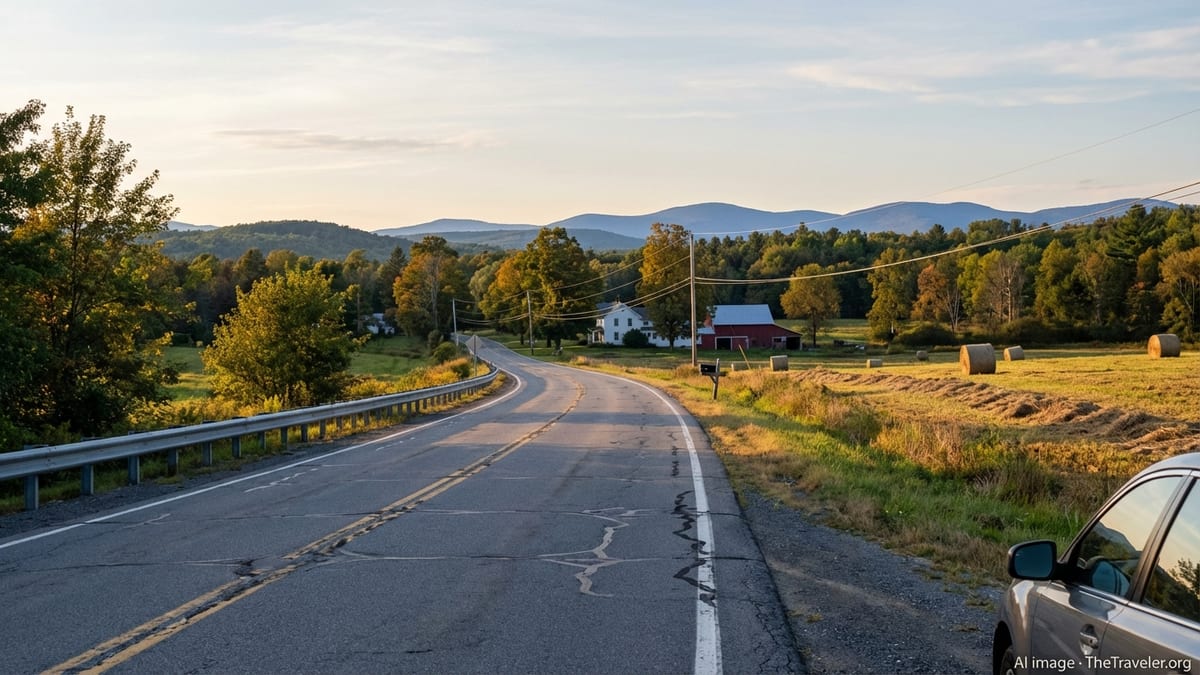
Most out-of-state visitors arrive in New York on an interstate, watch the rest stops blur by, and exit in the city. I chose instead to enter via the long green ribbon of the Taconic State Parkway, a 100-plus mile, car-only route that climbs and dips along the eastern side of the Hudson Valley. Trucks are banned here, which changes everything: the pace is slower, the sightlines longer, and the views open onto farm fields, stone walls, and distant Catskill silhouettes instead of sound barriers and billboards.
Morning fog hung in the low spots as I drove north, rising off wetlands and clinging to apple orchards. There were no billboards shouting for attention, just the occasional brown sign pointing to a trailhead or a town you might miss if you blinked. Rest areas were modest pull-offs with picnic tables and trail maps instead of chains and neon. On paper, this was just a way to get from the suburbs toward the heart of the state. In reality, it was my first hint that New York was still laced with roads designed for the simple pleasure of driving.
Each small exit along the parkway hinted at detours: a farm store here, a village with a white-steepled church there. Many drivers treat the Taconic as a fast alternative to the interstate, but if you give it time and allow yourself to exit often, it becomes a gateway into lesser-known corners of Columbia and Dutchess Counties. By the time I left the parkway and dropped toward the Hudson River, I felt as if I had been gradually rewired for a slower, more observant kind of travel.
Canal Towns and the Mohawk Towpath
In the middle of the state, where many travelers see only highway interchanges and outlet malls, the Mohawk River and the Erie Canal run quietly side by side. Parallel to them, a string of small roads form the Mohawk Towpath Scenic Byway, a designated route that links Schenectady to Waterford through old canal-side neighborhoods, pocket parks, and working locks. I left the main highway at Schenectady and picked up the byway almost by accident, following a sign that simply read “Historic Stockade District.”
What I found was a grid of 18th- and 19th-century houses, their stoops facing narrow streets that seemed scaled for horses rather than cars. A few blocks away, the canal opened like a quiet back alley of water behind the town. Cyclists rolled past on the path. The occasional tour boat moved through, but mostly it was locals walking dogs and teenagers fishing off the bank. It is easy to think of the Erie Canal as a relic from a textbook. Seen from the Mohawk Towpath, it feels surprisingly alive, integrated into everyday small-town life.
Driving east along the byway, I stopped often at small riverfront pull-offs. Interpretive panels told stories of locks and towpaths and the communities that boomed, then declined, along the waterway. None of the stops were grand destinations. That was the point. This part of New York reveals itself in accumulation: a clapboard church here, a quiet cemetery there, an old brick mill whose faded sign still hints at the goods that once moved down the canal to New York Harbor and beyond. By the time I reached Waterford, where the Mohawk meets the Hudson and a staircase of canal locks climbs the hillside, I understood why this short corridor has earned recognition as a scenic byway.
Most travelers blast along the nearby interstate between Albany and the Adirondacks, unaware that only a few miles away they could be following the actual artery that once opened the interior of the country. To drive the Mohawk Towpath is to trade speed for context. It slows you down just enough to feel how geography, water, and industry shaped this part of New York long before the age of exit numbers and service plazas.
Wild Heart of the Adirondacks Off the Main Routes
From Waterford, road-trippers often aim straight for the better-known resort towns of Lake George or Lake Placid. Instead, I angled into the Adirondack Mountains on smaller state routes and county roads, following the bends of rivers and the contours of old logging corridors. One of the most quietly beautiful stretches was Blue Ridge Road, a narrow, two-lane byway threading nearly twenty miles through forest and wetlands between Newcomb and the Northway.
On a paper map, Blue Ridge Road is just a connector. Behind the wheel, it feels like an immersion course in Adirondack landscape. The pavement curves past trailheads and roadside marshes rimmed with spruce. Low clouds snag on ridge lines. Long views open suddenly across beaver ponds, then close again in dark stands of balsam. There are no gas stations or motels along this road, just the occasional pull-off where you can listen to the wind in the trees and the distant rush of water.
Near Newcomb, I turned off toward a small town beach on a local lake. It was late afternoon, too cool for swimming, and the only other visitors were two people fishing from a dock. Behind them, high peaks formed a jagged blue horizon. The Adirondacks are famous for their big-name destinations, but it is these low-key town access points and unmarked car-top boat launches that deliver the sense of living, working forest. Locals park trucks loaded with firewood beside kayaks and bicycles. Children ride back and forth on gravel drives. Life in the Adirondacks is not a vacation postcard; it is an ongoing balancing act between tourism, conservation, and the routines of everyday rural communities.
Later, I followed another lesser-known route, the Roosevelt–Marcy Trail along portions of Route 28N, a scenic corridor that roughly traces Theodore Roosevelt’s urgent overnight journey from the high peaks to a railroad station after he learned of President McKinley’s failing health. Roadside markers tell that story in broad strokes, but what lingers most today is not politics; it is the simple drama of landscape. The road rises and falls through mixed hardwood and conifer forest, crosses quiet rivers, and passes hamlets whose single general store doubles as post office, deli, and social hub. Here, a road trip becomes an encounter with the resilience of small mountain communities as much as with protected wilderness.
Slow Shores of the Finger Lakes
From the Adirondacks, I swung southwest into the Finger Lakes, trading spruce and granite for rolling hills stitched with vineyards and orchards. Many visitors focus on the major wine trails and marquee towns, but the most revealing parts of this region lie in the quiet shore roads and farm lanes that arc between them. On a weekday morning, I followed a narrow route along the east side of Cayuga Lake, where the water lies long and still between steep slopes.
Roadside signs announced small family wineries, u-pick farms, and roadside stands selling whatever was in season. At one unassuming pull-off, I found a rough stairway down to a pocket-sized lakeside park: a strip of grass, a picnic table, and a view straight down the length of Cayuga. A couple of local residents sipped coffee on a bench; a lone kayaker cut a white line across the water. It was a reminder that the Finger Lakes are not just a destination for tastings and fall foliage drives. They are working landscapes, where grapes share space with cornfields, dairy barns, and small towns anchored by long-standing diners and hardware stores.
In one of those towns, far from the main highway, I stopped into a community-run café in a converted storefront. A chalkboard listed daily specials sourced from nearby farms. Flyers on a bulletin board advertised contra dances, watershed meetings, and farm-to-table suppers. Talk at the counter revolved around weather, harvests, and school sports. Travelers who skim the surface of the region on the main routes see wineries and waterfalls. Travelers who allow themselves to wander inland even a few miles find a local culture deeply rooted in land and water, shaped by generations of people who have built their lives around these long, glacial lakes.
One afternoon, chasing a sunset view, I took a road that climbed away from the lakeshore through fields already cut for hay. At the crest, I pulled onto the shoulder and watched as the late light slid along rows of vines and lit the water far below in streaks of silver. It was utterly still. No tour buses, no tasting-room crowds, just the low ticking of the engine and the smell of cut grass. In moments like this, the Finger Lakes reveal their quieter side, one that rarely appears in glossy brochures but lingers in memory long after the last tasting flight.
Catskill Passes, Not Resorts
South of the capital region, the Catskill Mountains rise in a series of forested plateaus and deep notches. Classic resort towns still draw summer crowds, but I chose to explore via the mountain passes that thread between peaks rather than the main village streets. One of the most rewarding drives followed Route 214 through Stony Clove Notch, a narrow cleft between steep slopes where cliffs press close to the pavement and a small stream keeps pace with the road.
In places, the forest leaned so close that it felt as if I were driving through a green tunnel. Trailheads appeared suddenly at sharp bends: a few cars pulled onto gravel, weathered wooden signs pointing up to high summits. This stretch of road is designated as part of the Mountain Cloves Scenic Byway, but there are few formal overlooks or visitor centers. The drama lies in the immediate, intimate scale of the landscape. One moment you are in a shaded, tight-walled pass; the next you emerge into a wider valley with old farmsteads and weathered barns that speak to a time when these roads served as lifelines for isolated mountain communities.
Later, I linked this route to segments of the Shawangunk Scenic Byway farther south, where sheer cliffs rise above rolling farmland and small towns hold on to their Main Streets with quiet determination. Here, rock climbers share the road with farmers hauling hay. Bicyclists pause at hilltop pull-offs to catch their breath and their views. Travelers who limit their Catskills experience to a single mainstream town or resort miss how varied the region truly is. The back roads reveal working quarries, lakeside camps, covered bridges, and trailhead parking lots that function as social spaces for weekend regulars.
In the evening, I found a modest roadside motel with Adirondack chairs lined up outside each door. Families grilled on portable barbecues in the parking lot. A dog slept under a picnic table. It was an unremarkable scene in one sense, but it felt closer to the heart of New York’s mountain culture than any grand lodge lobby could. The Catskills, seen from their passes and byways, are a place where tourism and everyday life occupy the same space, sometimes in tension, often in quiet harmony.
Lake Shores, Lighthouses, and the Great Lakes Edge
From the central highlands, my route arced north and west again until it met the broad, restless edge of Lake Ontario. Instead of following the fastest highway along the shore, I picked up portions of the Great Lakes Seaway Trail, a long scenic route that hugs the inland sea across northern New York. Here the landscape changes character again. Vineyards give way to orchards and flat fields. The lake itself is less a backdrop and more a dominant presence, filling the horizon with shifting blues and grays.
Along quieter stretches of the trail, small harbor towns cluster around marinas and weathered lighthouses. In one, I walked a short breakwall to a historic light tower, its paint peeling but its lantern still active. A few anglers stood with coolers at their feet, casting into the chop. Behind us, the town was a snug grid of streets with clapboard houses, a diner, and a park where children played within sight of the water. These communities know the lake not as a scenic extra, but as a powerful neighbor whose moods shape weather, commerce, and daily routines.
Driving between towns, the Seaway Trail frequently narrows to near-rural lanes that run just inland from the shoreline. Fields press close to the water, interrupted by woodlots and small creeks. Farm stands sell apples, maple syrup, and baked goods from sheds that look unchanged for decades. It would be easy to miss these stops when the weather is bad and the wind comes hard off the lake, but on a clear day they are among the most inviting pauses on a New York road trip. Each one offers a small window into local life in a region that many travelers know only as a distant blue shape on a map.
At sunset, I pulled into a lakeside park where the trail meets a modest public beach. Teenagers skipped stones into the shallows. Couples watched the sky shift from gold to pink to deep violet. There were no loud music systems or boardwalk amusements, just the steady slap of waves and the murmur of conversation. Standing there, it struck me that I had driven from mountain notches to inland seas without ever fully leaving New York State. The diversity of landscapes along this single road trip route is part of what so many visitors miss when they see New York only as a city or a set of iconic landmarks.
The Human Side of the Back Roads
What ultimately defines a road trip is less the scenery than the series of human encounters that stitch the miles together. On this journey, those moments rarely occurred at major attractions. Instead, they unfolded at gas stations where the clerk knew every customer by name, at diners where the same people filled the same corner booths each morning, and at farm markets where handwritten signs encouraged visitors to pay on the honor system.
In a small town near the Mohawk Valley, I stopped at a volunteer-run museum housed in a former school. The door was unlocked, the lights off, and a bell on the counter invited visitors to ring for assistance. When I did, a retiree appeared from a side room, delighted that someone had stopped in on a weekday afternoon. For an hour, he walked me through exhibits on local industry, one-room schoolhouses, and a long-abandoned trolley line. None of this would appear on a top-ten list of New York attractions, yet it provided a depth of context for the landscape outside that no brief roadside sign could match.
In another town, I visited a small independent bookstore on a side street. The owner recommended novels by local authors and pointed out a shelf of regionally focused history titles. When I asked where to find a good view at sunset, she did not name a famous overlook. Instead, she sketched directions to a dead-end road above the river where locals parked to watch the light change. Places like this exist across New York State, but they rarely make it into guidebooks. You find them by asking questions, lingering in conversations, and signaling that you are interested in more than ticking sights off a list.
At a roadside farm stand in the Finger Lakes, a teenager weighing tomatoes told me about growing up between fields and lake, about summer jobs at u-pick orchards, and about her hopes to study environmental science while still staying close to home. Encounters like these complicate tidy ideas about rural life. They reveal communities that are adapting to climate shifts, evolving tourism, and changing economies, all while holding on to a sense of place that runs deeper than any brochure slogan.
The Takeaway
New York State is often summarized as a collection of superlatives: tallest buildings, largest waterfalls, most visited attractions. This road trip taught me that its truest personality emerges in the quieter spaces between those headlines. It lives in the parkways that still prioritize landscape over speed, in the canal towns that remember when water was the primary highway, in the mountain passes where trailheads outnumber souvenir shops, and in the lakeside communities that measure time by harvests and weather patterns rather than by show schedules.
To see this side of New York, you do not need an elaborate itinerary or a string of reservations. You need time, curiosity, and a willingness to trade the certainty of the interstate for the meandering logic of back roads and scenic byways. Take the smaller exit. Follow the brown sign. Stop at the pull-off that looks like it might have a view, even if it does not appear on your map app. Talk to the person behind the counter. Ask where they go on a day off.
Most of all, allow yourself to be surprised. New York State, approached this way, is not a single destination but a series of overlapping stories written in river valleys, mountain notches, lakeshores, and Main Streets. The city will always be there, its lights visible from far away. The quieter New York, the one most travelers miss, is waiting just beyond the next exit ramp.
FAQ
Q1. What is the best time of year to take a New York State back-roads road trip?
Late spring through fall works well for most regions, with September and early October offering a balance of mild weather, open attractions, and changing foliage in many parts of the state.
Q2. How many days should I plan for a road trip like this?
To travel at an unhurried pace and explore several regions, plan at least seven to ten days. With less time, focus on one or two areas rather than trying to cross the entire state.
Q3. Do I need a four-wheel-drive vehicle for these routes?
No. The routes described are primarily paved state highways, parkways, and county roads. A standard car in good condition is generally sufficient, especially in warmer months.
Q4. Are there tolls on the roads mentioned in this itinerary?
Some major expressways and the main thruway in New York charge tolls, but many of the scenic byways and smaller routes described here are toll-free. Check your planned route in advance.
Q5. Is it easy to find fuel and services on these lesser-known roads?
Fuel and basic services are available in most towns, but there can be longer stretches without stations in the Adirondacks and other rural areas. It is wise to refuel before heading into remote sections.
Q6. Can I rely on mobile navigation in these regions?
Navigation apps work well in most populated areas, but signal can be inconsistent in mountain passes and deep rural valleys. Download offline maps and carry a paper map as a backup.
Q7. Do I need reservations for lodging along these back roads?
In peak seasons such as midsummer and fall foliage, it is prudent to book ahead in popular regions like the Adirondacks, Catskills, and Finger Lakes. In shoulder seasons, you may have more flexibility.
Q8. Are there specific driving restrictions on parkways like the Taconic?
Yes. Certain parkways restrict trucks, trailers, buses, and over-height vehicles. Before driving, confirm that your vehicle type is allowed and pay attention to posted clearance signs.
Q9. Is this kind of road trip suitable for families with children?
Yes, if you build in frequent stops. Short hikes, canal lock visits, lakeside parks, and small-town playgrounds can break up driving days and keep children engaged.
Q10. How can I travel responsibly in these smaller communities?
Support local businesses, follow posted rules at parks and trailheads, keep noise down in quiet areas, and leave places as you found them. A considerate approach helps ensure these routes remain welcoming for future travelers.