
If you are driving the length of New Jersey, sooner or later you face the same choice: New Jersey Turnpike or Garden State Parkway. Both roads run roughly north to south for most of the state, both charge tolls and both can deliver you to New York connections or the Jersey Shore. Yet they feel very different behind the wheel and one can make far more sense than the other depending on where you are going, when you drive and what kind of trip you want.
Get the latest updates straight to your inbox!
Understanding the Two Highways
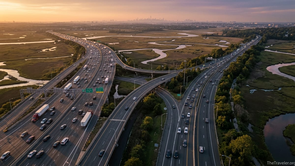
The New Jersey Turnpike is New Jersey’s main long distance freight and commuter spine. It runs about 122 miles from just east of the Delaware Memorial Bridge in the south to the George Washington Bridge approach in the north, carrying Interstate 95 for much of its length. Expect three to four lanes each way, frequent tractor trailers and a heavily engineered feel, especially through the industrial corridor around Newark and Elizabeth.
The Garden State Parkway stretches roughly 172 miles from Cape May at the southern tip of the state to the New York State line at Montvale. It tracks closer to the coast for much of its route and is the classic way to reach destinations like Ocean City, Seaside Heights, Asbury Park and the Monmouth County beach towns. While much of it is modern highway, it still retains landscaped medians, gentle curves and more trees than the Turnpike, especially south of Toms River.
Structurally, the Turnpike is set up for heavy interstate traffic. It uses ticket style tolling for the mainline, meaning you get a ticket or electronic record at your entry point and pay when you exit, with price based on distance and vehicle class. The Parkway blends barrier toll plazas and ramp tolls, so you pay smaller amounts at several points instead of one bigger bill.
In practical terms, the Turnpike usually makes more sense for through traffic that is not stopping at the Shore, while the Parkway usually serves best as the access road to coastal New Jersey. The complication is that in central and northern New Jersey the two come close together and often both appear in navigation apps, which is when knowing their differences saves time and frustration.
Route Choice by Typical Trip
Consider a common trip: Philadelphia suburbs to New York City. If you are leaving from Cherry Hill or Mount Laurel, most drivers take Interstate 295 north to the New Jersey Turnpike and then follow it to the Newark interchange before continuing to the Lincoln or Holland Tunnel or to the George Washington Bridge. Using the Parkway here would mean cutting east toward the Shore then back west again, adding time with no benefit.
Now take a different trip: North Jersey suburbs to Seaside Heights in summer. Starting in Paramus or Clifton, the Garden State Parkway is usually the cleaner choice. You join the Parkway around milepost 160 and head south directly to exit 82 for Route 37 and Seaside Heights. Staying on the Turnpike would require dropping south toward New Brunswick, then cutting east on local highways that often clog on summer weekends.
If you are driving from Washington, D.C. or Baltimore to Cape May, the choice is mixed. One popular strategy is to stay on Interstate 95 to the Delaware Memorial Bridge, pick up the New Jersey Turnpike briefly and then shift to Route 55 and local roads toward Cape May. Another is to cross into New Jersey, join the Turnpike for a short distance, then connect to the Garden State Parkway at its southern end. Drivers who prefer a simpler route often choose the Parkway for the last leg because it feeds directly into the Cape May area without as many small town traffic lights.
For people shuttling between central New Jersey and points like Newark Liberty International Airport, the Turnpike almost always makes more sense. Hotels around New Brunswick or Princeton typically advise guests to use the Turnpike, since it has direct interchanges for the airport and for the Newark Bay Extension toward Jersey City, while the Parkway generally requires extra connectors.
Tolls, Costs and How They Compare
Both highways charge distance based tolls that have risen in recent years, with electronic payment using E ZPass now the normal way to pay. A full length Turnpike trip in a standard two axle passenger car with E ZPass typically costs in the mid teens in dollars, according to recent toll calculators that incorporate the latest New Jersey Turnpike Authority rate schedules. Cash rates tend to match or be only slightly higher, though some interchanges are now cashless.
On the Garden State Parkway, tolls are broken up into smaller pieces. Mainline barrier plazas such as Bergen, Essex, Union, Raritan, Asbury Park and Cape May currently charge about 2 dollars and 25 cents for an E ZPass passenger car, while smaller ramp plazas and exits often cost under 1 dollar each. For example, the Belmar or Brick ramp tolls are generally under 1 dollar for a car with E ZPass, while the Toms River mainline plaza posts a little over 1 dollar for the same vehicle class. Over the length of a northern New Jersey to Cape May run, cumulative Parkway tolls often land within a few dollars of a comparable Turnpike distance.
For real trip budgeting, tools such as New Jersey specific toll calculators let you plug in a route like Newark Airport to Atlantic City via either road and see combined tolls and estimated fuel costs. These typically show that, for a passenger car, choosing Parkway over Turnpike or vice versa rarely changes the total by more than a handful of dollars for a single trip. The bigger financial differences come from time saved or lost in traffic and from fuel burned in stop and go conditions versus steady cruising.
If you are renting a car at Newark Airport, note that most national rental brands such as Hertz, Enterprise and Avis offer toll programs that bill E ZPass style charges back to your card with an administrative fee per day of use. That fee can be several dollars per day on top of the toll, sometimes dwarfing the toll itself on shorter Parkway segments. In those cases it can be worth asking at the counter whether your rental includes an E ZPass transponder and what the daily surcharge is before you decide how many tolled miles to drive.
Traffic Patterns, Speed and Driving Experience
Weekday traffic on the New Jersey Turnpike is dominated by long haul trucks and commuters. Speed limits are generally 65 miles per hour on rural stretches, with some sections dropping near major interchanges. Free flow speeds often run a little higher in light traffic, but enforcement can be visible, particularly around the split inner and outer roadway segments closer to Newark and the approaches to major bridges.
The Garden State Parkway also runs mostly at 65 miles per hour on its mainline, though some older, more curved sections and areas near interchanges drop lower. In northern New Jersey, especially between the New York State line and around the Raritan toll area, traffic density can be intense during rush hours in both directions. South of around milepost 80 near Toms River, the Parkway often feels calmer outside peak summer weekends, with longer stretches of tree lined median and more of a relaxed holiday vibe.
From a driving experience standpoint, the Turnpike is more utilitarian. You see refineries near Linden, container ports along Newark Bay and clusters of warehouses, especially around Elizabeth and Carteret. The highlight for many is the elevated section crossing the Meadowlands with distant views of the Manhattan skyline, but overall it is a functional road built to move freight and passengers efficiently.
The Parkway, especially south of the Raritan River, is closer to what visitors picture when they imagine a scenic parkway. Landscaping, tree cover and more frequent overpasses give it a more enclosed feel. In late summer, a late afternoon drive between Asbury Park and Cape May can mean gentle light filtering through pines and glimpses of marshland near exits for shore towns such as Manahawkin or Somers Point. It is not a coastal cliff drive, but it does offer a more pleasant backdrop than the Turnpike if you care about scenery.
Access to Shore Towns, Cities and Airports
If your destination involves sand and boardwalks, the Garden State Parkway generally wins. It has direct or nearly direct exits for most major Jersey Shore towns. For example, exit 98 connects to Route 34 and Route 138 for Point Pleasant and Manasquan, exit 63 connects to Route 72 for Long Beach Island, exit 38 links to the Atlantic City Expressway for casinos and the boardwalk, and exits in the 20s and teens serve Ocean City, Sea Isle City, Avalon, Wildwood and Cape May.
The New Jersey Turnpike intersects fewer direct feeders to beach towns. Travelers often use it as a fast north south trunk, then connect west or east using state routes. A realistic example: driving from New Haven, Connecticut to Ocean City, New Jersey, some drivers stay on Interstate 95 to the Turnpike, then cut over via the Atlantic City Expressway and local roads. Others swing onto the Parkway earlier near Woodbridge to avoid some urban congestion. In most of those cases, however, the Parkway still handles the final segment into the shore region.
For airports and major cities, the Turnpike is more straightforward. Newark Liberty International Airport sits almost on top of the Turnpike, with signed exits that feed directly into the airport ring roads. Jersey City, Hoboken and lower Manhattan are reached easily via the Turnpike’s Newark Bay Extension toward the Holland Tunnel, while the Turnpike’s northernmost stretches guide drivers to the George Washington Bridge and connections into upper Manhattan and the Bronx.
The Parkway does offer access to urban centers such as Newark, Elizabeth and the Oranges through interchanges in Essex and Union counties, but it is rarely the most direct path for airport pickups or downtown business hotels. Where the Parkway does shine on the urban side is access to suburban hubs like Paramus, Montvale and other Bergen County towns with their malls and office parks, where exits are designed around commuter patterns rather than long distance freight.
Service Areas, Rest Stops and Amenities
Both highways are dotted with service areas and rest stops that offer fuel, food and restrooms. On the New Jersey Turnpike, these are full scale plazas spaced roughly every 20 to 30 miles, many of which have been renovated in the last decade. Names such as Molly Pitcher, Joyce Kilmer and Clara Barton are common waypoints for regular drivers. Inside you typically find a mix of national fast food chains, coffee counters and convenience store style markets, along with large fuel stations that serve both cars and commercial trucks.
On the Garden State Parkway, service areas are somewhat more varied. North of the Raritan River, you encounter full plazas often named for New Jersey cultural figures and Hall of Fame inductees. South of that, some areas are simpler rest stops with fuel, restrooms and a limited selection of food, though several have been upgraded with modern buildings and better lighting. Picnic style pull offs still exist in a few southern segments, popular with day trippers carrying their own food to the Shore.
For families, the main difference is predictability. The Turnpike’s plazas almost always offer multiple dining options, indoor seating and large restrooms, which can be reassuring if you are traveling with children late at night. The Parkway’s mix of full service and smaller facilities can mean planning stops a bit more carefully, especially south of Atlantic City where distances between major service areas can feel longer.
Travelers who value national coffee brands or sit down chains should review updated service area listings before a long trip if they have strong preferences. For example, if you know you will want a coffee before tackling the approaches to New York City, aiming for a larger Turnpike plaza north of New Brunswick or a sizable Parkway stop like the ones near Monmouth County can make the last hour of your drive more comfortable.
Which Road Is Better for Different Types of Travelers
For business travelers on a schedule, the New Jersey Turnpike is typically the smarter choice when the route options are genuinely equivalent. Its interchanges are designed to connect to other interstates and major bridges, signage is geared toward long distance drivers and lane layouts often separate cars and trucks, which can help traffic flow at busy times. If you are catching a flight from Newark or driving a rental car from the airport to Philadelphia, the Turnpike’s directness is hard to beat.
For vacationers heading to beach rentals, campgrounds or shore hotels, the Garden State Parkway often feels like the natural path. The exits are clearly numbered for shore towns, traffic patterns are familiar to seasonal visitors and the overall atmosphere is a bit more relaxed. If your trip runs on a Saturday in July from North Jersey to Wildwood, for example, the Parkway will be crowded, but it is crowded in the same direction as your fellow travelers, with plenty of signs pointing to beach destinations.
Families with nervous drivers sometimes prefer the Parkway south of Toms River because truck restrictions reduce the number of large rigs, especially in segments where heavy trucks must divert to alternative routes. Conversely, drivers uncomfortable with cloverleaf interchanges, shorter entrance ramps or older style Parkway exits may appreciate the Turnpike’s more modern entry and exit geometry, especially around major hubs.
Budget conscious solo travelers might prioritize whichever road allows steadier speeds and fewer time wasting jams. In practice this often means checking a live traffic app shortly before departure. On a rainy fall weekday, the Turnpike might be clearer between New Brunswick and Newark than the Parkway, while on a Sunday afternoon in August the reverse is more likely. No fixed rule beats a quick look at current travel times when cost and time matter most.
The Takeaway
Choosing between the New Jersey Turnpike and the Garden State Parkway is less about which road is objectively better and more about which one aligns with your trip. The Turnpike is New Jersey’s main freight and interstate artery, ideal for airport runs, business travel and long distance drives that only happen to pass through the state. The Parkway is the Shore highway and suburban connector, carrying vacation traffic, day trippers and commuters between coastal towns and northern suburbs.
On most routes, toll costs end up broadly similar for a standard car, so your decision should hinge more on destination, time of day, appetite for scenery and comfort with heavy trucks or complex interchanges. For a July weekend escape from Paramus to Cape May, the Parkway is the natural pick. For a Tuesday morning sprint from Philadelphia’s suburbs to Newark Liberty Airport, the Turnpike usually wins.
Before you go, plug both options into a navigation app with live traffic, glance at current toll estimates from a New Jersey toll calculator and consider where along the way you will want to stop for fuel or food. With a few minutes of planning, you can let each highway play to its strengths and arrive with less stress, whether you are watching the sun set over Cape May’s beaches or the lights of Manhattan from a hotel near the Hudson.
FAQ
Q1. Which is usually faster, the New Jersey Turnpike or the Garden State Parkway?
The faster route depends on where you are starting and ending and on live traffic. For trips between Philadelphia, Newark and New York City, the Turnpike is often faster. For trips between North Jersey and Jersey Shore towns, the Parkway usually wins, especially outside peak rush hours.
Q2. Is one road cheaper than the other for tolls?
For a standard two axle car, total tolls for comparable distances are often within a few dollars of each other. The Turnpike tends to collect one larger toll based on distance, while the Parkway spreads charges across several smaller plazas and ramps.
Q3. Which route is better for reaching the Jersey Shore?
The Garden State Parkway is generally better for reaching most Jersey Shore towns. It has direct exits for popular destinations like Long Beach Island, Atlantic City, Ocean City, Wildwood and Cape May, reducing time spent on smaller local roads.
Q4. Which is better for getting to Newark Liberty International Airport?
The New Jersey Turnpike is the better choice for Newark Liberty International Airport. It runs right past the airport with clearly signed exits that feed directly into the terminal roadways.
Q5. Are there more trucks on the Turnpike or the Parkway?
The New Jersey Turnpike carries far more long haul truck traffic, especially on central and northern segments. The Parkway has restrictions on heavy trucks on certain stretches, particularly in the south, which can make it feel less intimidating for some drivers.
Q6. Which road is more scenic?
The Garden State Parkway is more scenic, especially south of Toms River, with tree lined medians, landscaped interchanges and occasional marsh and water views near Shore exits. The Turnpike is more industrial, though it does offer skyline views around the Meadowlands.
Q7. How do service areas compare between the two highways?
The Turnpike has large, full service plazas every 20 to 30 miles with multiple dining options, fuel and big restrooms. The Parkway mixes full service plazas in the north with more modest stops in some southern segments, so planning ahead for food and fuel can be more important on the Parkway.
Q8. Which should I choose in heavy summer traffic?
In peak summer traffic, choose the road that keeps you on limited access highway the longest and matches your destination. For beach trips, that still usually means the Parkway, even if it is crowded. For through trips that just cross New Jersey, the Turnpike is usually more efficient.
Q9. Is one road easier for nervous drivers?
Nervous drivers often prefer the Parkway south of Toms River because there are fewer large trucks and the scenery feels calmer. Others prefer the Turnpike’s wider lanes and more modern interchanges. If possible, check both options in light traffic first to see which feels more comfortable.
Q10. Can I rely on GPS alone to choose between the Turnpike and Parkway?
Navigation apps are helpful because they factor in live traffic, but they do not always account for your preferences about scenery, trucks or complex interchanges. Use GPS for time estimates, then overlay your own priorities before committing to one route.