
More news on this day
Tel Aviv’s city map is being redrawn in practice, as new light rail services, refreshed municipal maps and updated neighborhood guides give visitors a different way to understand Israel’s coastal hub.
Get the latest news straight to your inbox!
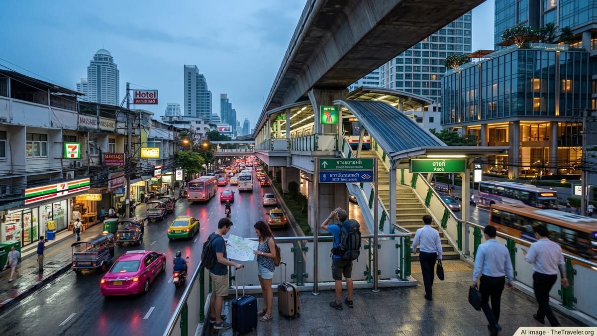
Light Rail Redefines the Mental Map of Tel Aviv
The opening of the Red Line of the Tel Aviv light rail in August 2023 has become a central organizing feature of new city maps, shifting attention from car routes to rail corridors. Publicly available information on the line shows it running from Bat Yam in the south through Jaffa and central Tel Aviv to Petah Tikva in the northeast, combining underground tunnels with surface tracks along major arteries. Tourist and transport guides now increasingly depict Tel Aviv not only as a compact beachfront city but as the core of a wider metropolitan grid linked by rail.
Network diagrams produced by transit specialists and enthusiast sites present the Red Line as the backbone of a future multi-line system, with Green and Purple lines under construction and metro lines planned. On many updated schematic maps, the Red Line forms a bright spine through the city center, with icons marking key stations near major landmarks such as the HaHagana and Savidor railway hubs, the Florentin district and the stadium zone south of Jaffa. This rail-focused cartography reflects a broader policy shift toward public transport in the greater Tel Aviv area.
These developments are beginning to filter into general-purpose city maps used by visitors. International mapping platforms and commercial guide publishers have started to add light rail stations and alignments to their Tel Aviv layers, though coverage varies between services. The result is a growing divergence between older paper maps, which emphasize through-roads and parking, and newer digital maps, which foreground tram stops, transfer nodes and pedestrian access routes.
For travelers, this means that a current map of Tel Aviv will likely look noticeably different from one printed a decade ago. The same streets and beaches appear, but the cartographic hierarchy has changed, with rail lines now cutting across the city’s grid and offering a new frame of reference for orientation and route planning.
Municipal Maps Highlight Beaches, Parks and Cultural Landmarks
The Tel Aviv municipality and tourism bodies continue to publish their own city and bus maps, giving an official picture of how the city wants visitors to move and what it wants to highlight. A recent municipal tourist map places particular emphasis on the seafront, with a continuous strip of labeled beaches, promenades and access points running from the northern shoreline down toward Jaffa. Parks such as HaYarkon and landmark squares like Rabin Square appear as large, clearly colored blocks, making green and civic spaces easy to spot.
Publicly available municipal cartography also draws attention to cultural institutions, including the Tel Aviv Museum of Art, the Museum of the Jewish People, and clusters of galleries and performance venues around central boulevards. Icons and pictograms are used to distinguish museums, markets, viewpoints and heritage sites, while major hotel zones and nightlife streets are marked in a way that aligns with the city’s tourism strategy documents.
Compared with generic web maps, these official city sheets often provide more detailed information on bus corridors and local service routes that tie neighborhoods to the beachfront and key attractions. They also tend to be bilingual or trilingual, combining Hebrew and English place names and occasionally transliteration in other languages. For visitors relying on printed material from hotels or tourist information points, these municipal maps remain a primary reference, especially in areas where narrow streets or older buildings can confuse GPS positioning.
The municipal approach underlines Tel Aviv’s dual identity as both a working metropolis and a leisure destination. By balancing transit lines with parks, cultural venues and heritage quarters on the same canvas, the city map functions as a visual summary of how officials expect people to experience and move through urban space.
Neighborhood Guides Redraw Tel Aviv into Distinct Districts
In parallel with transport-focused maps, neighborhood guides have popularized a more fine-grained division of Tel Aviv into distinct urban “villages.” Travel publications and online city guides commonly present the map in terms of clusters such as Rothschild Boulevard and Neve Tzedek, the historic port of Jaffa, the central business district around Azrieli, and the creative quarters north of the Yarkon River.
These guides typically overlay the street grid with soft neighborhood boundaries, highlighting where architectural styles, nightlife zones and demographic patterns shift from one area to another. In map form, the White City’s Bauhaus core is often shaded or outlined to reflect its UNESCO status, while Neve Tzedek appears as a compact enclave of smaller blocks between the city center and the shoreline. Jaffa, by contrast, is drawn as a large, irregular shape anchored by the old port and surrounding markets, merging ancient street patterns with modern promenades.
Such cartographic storytelling influences visitor expectations. Travelers using neighborhood maps may plan a day around moving through two or three adjacent districts on foot, rather than treating Tel Aviv as a single continuous center. Wayfinding is then shaped less by numbered streets and more by named quarters, plazas and linear landmarks like Rothschild Boulevard or the beach promenade.
Digital mapping services and independent design projects have reinforced this trend, offering stylized neighborhood maps that prioritize character over strict geographic accuracy. These visuals, often circulated through travel blogs and social media, help fix certain areas in the global imagination and can, in turn, drive increased foot traffic to specific streets, markets and café-lined avenues.
Digital Platforms Compete to Map Tel Aviv in Real Time
As Tel Aviv’s infrastructure changes, major digital mapping platforms and navigation apps are engaged in a continuous effort to keep their city layers current. Reports and user feedback over the last two years describe staggered rollouts of the new light rail line, with some services adding station markers and underground alignments more quickly than others. In many cases, satellite imagery still shows construction sites where live maps now depict finished tracks and operating services.
Real-time data feeds from Israel’s public transport databases have increased the level of detail available to app developers. Newer transit-focused apps now display live arrival times, route alternatives and accessibility information for light rail and buses in the Tel Aviv metropolitan area. For visitors, this means the practical city map is as much a dynamic timetable as a static plan, with routes recalculated around traffic, service changes and security-related disruptions.
Commercial mapping services also incorporate pedestrian routing along the beachfront, through park networks and across major junctions where rail lines intersect with streets. In central Tel Aviv, turn-by-turn guidance often relies on well-known landmarks and plazas, reflecting the dense mesh of short blocks and side streets. In older quarters such as Jaffa, where alleys and stairways complicate navigation, digital maps sometimes lag behind on-the-ground reality, leading to occasional discrepancies between screen directions and physical access.
This competition to offer the most accurate and user-friendly depiction of Tel Aviv has created a multi-layered mapping environment. A visitor may consult an airline’s destination map on the flight, use a municipal tourist plan on arrival and then rely on two or three separate apps during their stay, each presenting slightly different interpretations of the same streets and transport lines.
Security Context and Practical Map Use for Travelers
Recent regional tensions have added an extra dimension to how travelers interpret and use city maps of Tel Aviv. Travel advisories from various governments continue to emphasize situational awareness, and mapping tools form part of that picture. Many digital apps now highlight locations of public shelters or clearly identify railway and bus stations that function as emergency gathering points, although the level of detail and prominence varies between platforms.
Published guidance for visitors encourages the use of official and regularly updated mapping sources when planning routes, particularly for cross-city journeys or late-night travel. In practice, this often means cross-checking municipal or national transport maps with live navigation apps to account for temporary closures, demonstrations or short-notice changes to public transport timetables.
For most travelers, these considerations translate into small adjustments rather than wholesale itinerary changes. The compact nature of central Tel Aviv means many key attractions remain within walking distance of each other, and beachfront promenades offer clear physical orientation that is easy to follow even when devices are offline. Nevertheless, current events have made the reliability and recency of mapping information an important part of pre-trip planning.
Tel Aviv’s evolving city map now reflects both its role as a cutting-edge Mediterranean metropolis and its complex regional environment. Rail lines, shaded heritage districts, beachfront icons and transport overlays together form a layered portrait of a city that continues to grow, densify and redefine how it is navigated on paper and on screen.