
More news on this day
New York City travelers are being urged to brace for significant disruptions today as a fast-moving storm system threatens heavy rain, street flooding and wind gusts approaching 50 miles per hour across the region.
Get the latest news straight to your inbox!
Storm system targets a densely packed travel corridor
Public forecasts indicate that a frontal system is moving into the New York metropolitan area with the potential to deliver periods of intense rainfall, embedded thunderstorms and strong, shifting winds through tonight. Meteorologists highlight a risk of localized flash flooding where the heaviest downpours line up over urban neighborhoods and major roadways.
New York City sits at the heart of one of the busiest travel corridors in the United States, linking three major airports with intercity rail lines, regional buses, ferries and an extensive subway network. With the storm expected to arrive during key commuting and event windows, even brief bursts of heavy rain could ripple quickly through already crowded terminals and congested highways.
Forecast discussions circulated by weather specialists point to a warm, humid air mass feeding into the system, providing fuel for thunderstorms capable of producing torrential rain in short timeframes. Wind gusts in the 40 to 50 mile per hour range are being flagged as a concern, particularly near the coast and in open, elevated areas.
Travelers are being advised through local media coverage and agency alerts that rapidly changing conditions are possible throughout the afternoon and evening, with showers intensifying quickly along the leading edge of the cold front before tapering off gradually into Tuesday.
Flood watch and wind hazards raise concerns for commuters
Publicly available information from regional forecast centers indicates that the New York City area is under a flood watch due to the potential for heavy rainfall over a short period. In a dense urban environment with large expanses of pavement and aging drainage infrastructure, even a couple of inches of rain falling quickly can overwhelm sewers and send water coursing onto streets and into low-lying underpasses.
Transportation updates shared through local broadcast outlets and online platforms warn that typical trouble spots, such as highway on and off ramps, viaducts, and intersections with clogged catch basins, could see standing water as the heaviest bands of rain move through. Motorists are being reminded that water depths can be difficult to judge at night or in poor visibility, increasing the risk of stalled vehicles and sudden lane closures.
In addition to flooding, strong, gusty winds are an emerging focus for planners. Forecast discussions reference the potential for 40 to 50 mile per hour gusts with stronger storms, raising the possibility of downed tree limbs, scattered power outages and debris on roads. These conditions can cause sudden slowdowns on bridges and elevated highways, and may prompt temporary speed restrictions or lane closures if visibility or safety becomes a concern.
Rail commuters may also experience weather-related delays if water accumulates near tracks or if wind-driven debris interferes with overhead lines and signals. While the scale of the disruption will depend on the exact track and intensity of the storms, the combination of heavy rain and gusty winds has repeatedly proved challenging for the region’s tightly interconnected transit network.
Air, rail and road travelers urged to build in extra time
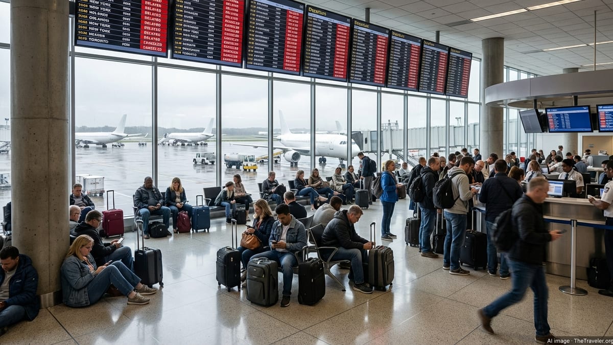
Coverage from regional news outlets suggests that airlines and transit agencies are preparing for the likelihood of slower operations as the storms move through. Thunderstorms in the New York airspace can trigger ground stops or flow control programs, slowing arrivals and departures at John F. Kennedy International, LaGuardia and Newark Liberty airports and creating backups that spread across national flight schedules.
Even when the storms are brief, lightning in the vicinity of terminals can temporarily halt ramp activity, delaying the movement of baggage, refueling and boarding. Travelers with flights scheduled for this afternoon and evening are being encouraged in public advisories to monitor airline alerts, anticipate possible gate or time changes, and allow additional time to move through security and weather-affected traffic near the airports.
On the ground, regional bus carriers and intercity rail services are expected to operate, but may experience slower running times in heavy rain, particularly along low-lying sections of highway and track. Local coverage notes that increased congestion is likely as drivers reduce speed and as minor accidents accumulate during downpours, compounding delays on major routes like the Long Island Expressway, Cross Bronx Expressway and New Jersey Turnpike approaches.
For those relying on subways and commuter rail, transit watchers point out that intense rain has previously led to water spilling into some stations, stairwells and tunnels, especially where infrastructure has already been stressed by earlier storms. Riders are being urged to check real-time service alerts, consider alternate routes and budget extra time for transfers in case of unexpected slow zones or temporary service changes.
World Cup crowds and summer visitors face added disruption
The timing of the storm presents an added challenge for the many visitors in the region for major sporting events and peak summer sightseeing. Recent coverage of international soccer fixtures in the New York and New Jersey area notes that stadium access routes, park-and-ride lots and surrounding local roads are particularly vulnerable to sudden slowdowns when heavy rain sets in close to kick-off.
Flood watches and severe weather outlooks issued for the wider metropolitan corridor suggest that areas around large venues could see significant ponding on roadways, with long lines of vehicles reduced to a crawl as drivers navigate through downpours and reduced visibility. Public transportation links to these events, including rail and bus connections, may also be impacted by weather-related slow orders and crowding as fans adjust their plans.
Tourist-heavy areas of Manhattan, Brooklyn and Queens could similarly see travel times lengthen as showers intensify. Visitors unfamiliar with the city’s geography and storm-prone spots may find it harder to reroute quickly, especially when relying on surface transportation such as taxis, rideshare vehicles and sightseeing buses.
Hospitality and tourism reports emphasize that indoor attractions, museums and restaurants may experience a surge in demand as outdoor plans are altered, further complicating the movement of people across the city. The storm is arriving during a period when hotels and short-term rentals in the region are already busy, limiting flexibility for those considering last-minute changes to their itineraries.
Safety tips and planning advice for travelers
Given the expected mix of heavy rain, localized flooding and strong wind gusts, travel guidance published by city and state agencies highlights a series of basic precautions for residents and visitors. Motorists are encouraged to avoid driving through pooled water, to maintain extra following distance and to reduce speed on slick roads, especially near construction zones, bridge approaches and known flood-prone intersections.
For those using public transportation, experts recommend building in a buffer of at least 30 to 60 minutes where possible, keeping mobile devices charged, and downloading official transit, airport or city alert apps to receive real-time updates on disruptions or station changes. Travelers on tight connections are being urged to review contingency options such as alternative routes, later departures or flexible tickets.
Pedestrians and cyclists are advised in public-facing guidance to stay alert for large puddles concealing potholes, for wind-blown debris, and for vehicles that may produce sudden spray near crosswalks and bike lanes. High-sided vehicles, scooters and bikes may be particularly affected by 40 to 50 mile per hour gusts on bridges and open stretches, making caution essential.
While forecasts indicate that the worst of the weather should ease by early Tuesday, travel planners stress that lingering delays are possible even after the heaviest rain has moved offshore. Residual congestion, signal issues and cleanup operations can all extend the impact of a single, intense storm system on one of the world’s busiest urban travel hubs.