
The Appalachian Trail is one of the world’s most iconic long-distance hikes, a nearly continuous footpath along the spine of the Appalachian Mountains from Georgia to Maine. For many hikers it is a once-in-a-lifetime challenge, whether they tackle a week-long section or attempt the full thru hike. Before you shoulder a pack and follow those familiar white blazes, it helps to understand how the trail is laid out, what distance you are truly looking at, how the states differ, and what day-to-day life on this legendary route is really like.
Get the latest updates straight to your inbox!
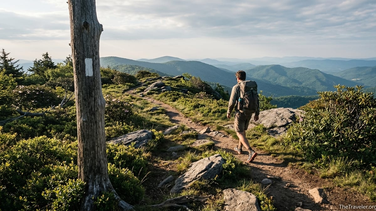
The Appalachian Trail in a Nutshell
The Appalachian Trail, often shortened to the A.T., runs between Springer Mountain in northern Georgia and Mount Katahdin in Maine. Official figures from the Appalachian Trail Conservancy put the current length at about 2,198 miles, though the exact number shifts slightly as the route is rerouted for conservation, safety, or land-access reasons. In practical terms, hikers often speak in rough terms of “about 2,200 miles” because year to year it may change by a few miles in either direction.
The A.T. is a dedicated footpath: no bicycles, no motorized use, and in most areas no horses. It threads through a patchwork of national parks, national forests, state lands, and private properties under easement. The character is overwhelmingly wooded. Even when the trail passes near major eastern cities, you are usually walking beneath trees rather than on open ridgelines. Hikers navigate using simple white paint blazes on trees and rocks, usually spaced close enough that you can see from one to the next in clear weather.
The trail attracts everyone from day hikers out of parking lots like Newfound Gap in Great Smoky Mountains National Park to thru-hikers aiming to cover the whole distance in a single season. A typical end-to-end hike takes about five to seven months, with many hikers averaging 12 to 15 miles per day once their legs adjust. Section hikers might dedicate a week every summer or long weekends in spring and fall, gradually piecing the trail together over many years.
Although the A.T. is challenging, it is also one of the most supported long-distance trails in the world. Marked side paths lead to shelters and tentsites, local volunteers maintain tread and signage, and dozens of nearby “trail towns” offer hostels, motels, restaurants, gear shops, and shuttles. For many people, this mix of wilderness and infrastructure is what makes a long walk through the Appalachians feel possible.
Route and States: From Georgia to Maine
The Appalachian Trail crosses 14 states, and each has its own personality. The traditional southbound start is at Springer Mountain in Georgia, reached by a rough forest road and a short approach hike from Amicalola Falls State Park. Those first Georgia miles roll through mixed hardwood forest, with steady ups and downs and a quick introduction to life on trail at places like Neels Gap, where the trail literally passes through the stone building of Mountain Crossings outfitter.
From Georgia the trail works northeast through North Carolina and Tennessee, weaving along the state line for long stretches. Here hikers encounter the high country of the southern Appalachians, including the balds of the Roan Highlands and the long traverse of Great Smoky Mountains National Park. Clingmans Dome, at more than 6,600 feet, is the highest point on the entire A.T. Weather can be volatile in this region; it is not unusual to see thru-hikers in March postholing through snow in the Smokies, then hiking in short sleeves a week later near Hot Springs, North Carolina.
Further north, the trail cuts across southwestern Virginia and spends hundreds of miles within that single state. Virginia includes famous highlights such as McAfee Knob, Dragon’s Tooth, Tinker Cliffs, and the wild ponies of Grayson Highlands. Many hikers talk about the “Virginia Blues,” not because the terrain is hardest here, but because the long distances between psychological milestones can wear on motivation. West Virginia and Maryland are comparatively short: the trail passes right through the historic streets of Harpers Ferry, home to the Appalachian Trail Conservancy’s headquarters and a popular psychological midpoint, then follows a ridge-and-valley pattern across Maryland to the Mason–Dixon Line.
Pennsylvania marks the beginning of the Mid-Atlantic section. Here the A.T. is notorious for rocky ridges that can be tough on ankles and shoe soles, especially between the Susquehanna River and the New Jersey border. New Jersey and New York surprise many hikers with long boardwalks through wetlands, occasional views of Manhattan’s distant skyline, and frequent road crossings leading to small-town delis. Connecticut and Massachusetts feel greener and gentler to many, with stretches along the Housatonic River, farm-country views, and the long forested ascent of Mount Greylock, Massachusetts’ highest peak.
As the trail enters Vermont, it overlaps with the Long Trail for more than 100 miles, bringing denser conifer forest and muddier tread, especially in early season. New Hampshire raises the difficulty sharply with its traverse of the White Mountains, where the route frequently climbs above treeline and uses rugged, rocky paths more akin to mountaineering scrambles than walking. Finally, Maine combines some of the wildest and most remote terrain on the entire trail, from the boggy lowlands near the state line to the famous Hundred-Mile Wilderness north of Monson and the final steep ascent of Mount Katahdin in Baxter State Park.
Distance, Timeframes, and How Far You Really Walk
On paper the Appalachian Trail is about 2,198 miles long. Hikers, however, quickly learn that their total distance will be greater. Detours to shelters, side trips down blue-blazed trails to water sources, miles walked in town for groceries and errands, and backtracking after missed turns all add up. Someone who completes the full trail might reasonably expect to walk several hundred additional miles beyond the official figure.
Most thru-hikers take between five and seven months to complete the route, though there are faster and slower completions. Northbound hikers leaving Georgia in early March might reach Maine in late August or September, while those starting later often risk snow in New Hampshire’s Presidential Range or an early closure of Katahdin’s summit trails. Southbounders who begin in Baxter State Park usually cannot start before early June due to snow and seasonal regulations, and they need to move quickly to finish in Georgia before serious winter weather hits the southern Appalachians in late fall.
Daily mileage varies widely. In the first weeks out of Springer Mountain, many new thru-hikers find that 8 to 10 miles feels like plenty, especially on steep climbs into the North Carolina high country. By Virginia, hikers who have grown trail-hardened often cruise at 15 to 20 miles per day across more moderate terrain. In rockier areas such as northern Pennsylvania, or in alpine stretches of New Hampshire and Maine, that average can drop again. A common planning rule among experienced hikers is to think in terms of time rather than miles: if you can comfortably hike for eight to ten hours a day and remain healthy, the miles will follow.
Section hikers and casual backpackers can use these norms to plan realistic itineraries. For instance, a fit group planning a five-day backpack in Shenandoah National Park might arrange for 12 to 15 trail miles per day between road crossings like Rockfish Gap and Thornton Gap, comfortable for most intermediate hikers with full packs. A family planning a three-day weekend in Massachusetts might aim for 7 to 9 miles a day between shelters near Mount Greylock, leaving time for breaks and short side trips.
Terrain, Difficulty, and Seasonal Conditions
The Appalachian Trail is not a technical mountaineering route, but it is significantly tougher than many first-time hikers expect. The path is often steep, rocky, and root-filled, with frequent short climbs and descents that can wear down legs and knees. Elevation gain for a full thru-hike adds up to an enormous number over the entire length, roughly comparable to climbing from sea level to the summit of Everest many times over, even if no single day feels extreme on its own.
Regional character plays a major role in perceived difficulty. In the South, long ascents through forest switchbacks lead to rounded summits and occasional grassy balds. The Smokies can bring deep snowpack or freezing rain in spring, and overnight temperatures can still drop well below freezing in April at higher campsites like those near Icewater Spring Shelter. Mid-Atlantic states tend to offer lower elevations but introduce prolonged rock hopping, especially in Pennsylvania, where hikers joke about “Rocksylvania” after long days negotiating basketball-sized boulders and sharp fragments.
New England raises the bar with steeper, rougher terrain and more time above treeline. In New Hampshire’s White Mountains, sections between Franconia Notch and Pinkham Notch involve rugged ascents, ladder-like rock scrambles, and long exposures on ridgelines such as Franconia Ridge and the Presidential Range. Weather can change rapidly here; it is entirely possible to experience bright sun, fog, and strong wind in the same hour. In Maine, bog bridges, roots, and wet rocks demand constant attention, and river crossings after heavy rain can require patience or alternate routes.
Seasonal timing matters. A northbound thru-hiker starting in early March may endure sleet and frozen water bottles in Georgia and North Carolina, then walk in humid heat through Virginia in June and July, followed by cool nights and fall colors in Vermont and New Hampshire. Day hikers planning a summer visit to Shenandoah, by contrast, might find hot afternoons, frequent afternoon thunderstorms, and lush green foliage in June or July, with black bears occasionally spotted near popular overlooks and picnic areas.
Trail Towns, Resupply, and Daily Life on the A.T.
One of the defining features of the Appalachian Trail is the network of nearby towns and services. While the footpath itself rarely runs directly down main streets, short side trails and road crossings provide access to communities where hikers can resupply food, shower, do laundry, and sleep in a real bed. In the South, well-known stops include Hiawassee and Franklin in Georgia and North Carolina, Hot Springs where the trail runs right through town past cafes and gear shops, and Damascus, Virginia, long marketed as “Trail Town USA.”
As hikers move north, the pattern continues. In central Virginia, towns like Daleville and Waynesboro sit near interstate exits with chain motels, grocery stores, and fast food. Harpers Ferry in West Virginia serves as a spiritual midpoint, where many thru-hikers take photos at the Appalachian Trail Conservancy visitor center. Farther along, small Pennsylvania communities such as Duncannon and Boiling Springs offer historic inns, pizza restaurants, and access to supermarkets within a short walk or shuttle ride from the trail. In New England, hikers often drop into Lincoln or North Conway, New Hampshire, from highway gaps in the Whites, and into Rangeley or Stratton, Maine, from remote road crossings.
Most thru-hikers resupply every three to five days. In a practical scenario, a hiker might leave Damascus with four days of food bought at a local grocery, hike to Marion or Atkins and resupply again at a dollar store or supermarket near the highway, then head back into the mountains. Some prefer to mail themselves food boxes to remote locations with limited choice, such as certain hostels or small general stores in Maine, but many modern hikers find they can buy enough along the way using a combination of big-box grocers, small-town markets, convenience stores, and restaurant meals.
Daily life on trail quickly settles into routine. A typical day might begin around sunrise with breakfast at a shelter or tentsite, followed by several hours of hiking before a lunch break at a view or stream. Many hikers stop mid-afternoon to refill water at springs or creeks and snack again. Evening often brings a decision: push on to the next shelter, with its three-sided structure and nearby privy, or set up a tent or hammock at a designated campsite. In heavily used areas such as Great Smoky Mountains National Park and parts of New England, regulations may require overnight stays only at official sites, while in other regions dispersed camping following Leave No Trace principles is more flexible.
Socially, hikers find a surprising sense of community. Trail names, informal nicknames adopted on the journey, replace real names in shelter logs and campfire conversations. Groups form and dissolve as people match pace or take rest days in town. On a busy spring day in northern Georgia, you might share a shelter with a dozen aspiring thru-hikers from across the United States and beyond. In quieter stretches of Maine in September, you might hike all afternoon without seeing another person, then trade stories with a small group around a fire ring at night.
Gear, Budget, and What Beginners Should Expect
Gear for the Appalachian Trail spans a wide range, from ultralight setups to traditional heavier kits, but a few essentials are nearly universal: a backpack sized around 50 to 65 liters for most thru-hikers, a shelter such as a lightweight tent or hammock, a sleeping bag or quilt appropriate for temperatures near freezing in shoulder seasons, sleeping pad, stove, water treatment, and layered clothing. Many hikers now use trail-running shoes instead of heavy boots, especially in the Mid-Atlantic and southern states, while switching to more supportive footwear in rockier New England sections.
Costs add up quickly over months on trail. While exact figures vary, many experienced thru-hikers recommend a rough budget of around 1,000 dollars per month on trail to cover food, lodging, transport, permits, replacement gear, and unexpected expenses. A hiker taking six months might therefore plan for 6,000 dollars or more, not including initial gear purchases. Someone section-hiking a week in Shenandoah National Park, by contrast, might spend far less: a park campsite or hut stay, groceries bought in a nearby town like Luray before entering the park, and perhaps a shuttle ride back to their car at the end.
For beginners, the key expectation is that the trail will feel harder, and more rewarding, than any training walk at home. Even relatively accessible sections involve carrying a loaded pack over uneven ground for many hours. Blisters, sore muscles, and chafing are common in the first days. Weather will not always cooperate; a weekend planned for campus views on McAfee Knob can turn out fogbound, with no scenery at all. Conversely, unexpected magic happens often: a church group in Virginia hosting a spaghetti dinner for hikers in a community center, or a lakeside shelter in Maine where loons call at dusk.
New hikers should also anticipate that their plans may change. A person who starts with the intention of finishing a full thru-hike may discover that injuries, finances, or family obligations require them to stop after a few hundred miles. Others who originally imagined only a short section might catch what many call the “A.T. bug” and return year after year. Going in with flexibility, a realistic budget, and an emphasis on safety rather than mileage goals helps keep the experience positive.
Safety, Regulations, and Environmental Considerations
Safety on the Appalachian Trail is mostly about preparation and judgment. The most common issues are overuse injuries, hypothermia in cool wet conditions, heat exhaustion in summer, and minor falls on slick rock or roots. Carrying a basic first-aid kit, extra calories, and a reliable way to stay dry and warm goes a long way. Many thru-hikers now carry a small satellite messenger or emergency beacon in addition to a phone, especially in remote areas of Maine or the Smokies where cellular coverage can be patchy.
Wildlife encounters are usually memorable for positive reasons, such as spotting a black bear slipping through the trees in Shenandoah or hearing coyotes at night in northern New England. Still, hikers must follow food-storage rules wherever they apply. In Great Smoky Mountains National Park and parts of New England, cables or bear boxes at shelters are provided; elsewhere, hanging food properly or using a bear-resistant canister is recommended. Snakes, including venomous species such as copperheads and rattlesnakes, are present in some states, so watching handholds and stepping carefully on warm rocks or in tall grass is important.
Regulations vary by jurisdiction. Great Smoky Mountains National Park and Baxter State Park require permits or registration for thru-hikers and have specific campsite rules. Some popular shelters in the Whites are managed by hut systems that charge for overnight stays during peak seasons, while nearby tent platforms may offer lower-cost alternatives. Alcohol, campfire restrictions, and group size limits can also differ. Checking current local rules before a trip, especially for specific segments like the Smokies, Shenandoah, or Baxter, helps avoid unwelcome surprises.
Environmental impact is a growing concern on the A.T. as use increases. Hikers are encouraged to follow Leave No Trace principles: camping only on durable surfaces, packing out all trash including food scraps and hygiene products, avoiding cutting switchbacks, and minimizing campfire use where dead wood is scarce. In some heavily used spots, you will see areas roped off for vegetation recovery or signs asking hikers to stay on rock or plank walkways over fragile wetlands. Respecting these measures helps ensure that future visitors experience a trail that still feels wild.
The Takeaway
The Appalachian Trail is much more than a line on a map. It is a living corridor of forest, ridgeline, and community stretching for roughly 2,200 miles across 14 eastern states. Understanding its route, the character of each region, the realistic distance and time involved, and what daily life actually looks like on the ground can transform the idea of the A.T. from an abstract dream into a concrete, planable journey.
Whether you envision a five-month thru-hike from Springer Mountain to Mount Katahdin, a focused week across Virginia’s scenic ridges, or a series of weekend outings in your home state, the same principles apply: respect the terrain and weather, plan conservatively, budget for the inevitable surprises, and stay flexible. The trail will test your legs and patience at times, but it will also reward you with misty dawns on southern balds, starry nights at remote shelters, and the steady satisfaction of moving under your own power through one of America’s great continuous landscapes.
For many hikers, the A.T. is less about standing on either terminus and more about everything that happens in between: the people you meet in shelters and diners, the small towns that stitch the route together, and the growing confidence that comes from solving problems far from home. Go in informed, prepared, and open to the unexpected, and the Appalachian Trail will more than meet you halfway.
FAQ
Q1. How long is the Appalachian Trail right now?
The Appalachian Trail is currently just under 2,200 miles long, with official figures around 2,198 miles, though small reroutes can change the exact number slightly year to year.
Q2. How many states does the Appalachian Trail pass through and which are they?
The trail passes through 14 states in this order for northbound hikers: Georgia, North Carolina, Tennessee, Virginia, West Virginia, Maryland, Pennsylvania, New Jersey, New York, Connecticut, Massachusetts, Vermont, New Hampshire, and Maine.
Q3. How long does a typical thru-hike of the Appalachian Trail take?
Most successful thru-hikers take about five to seven months to complete the full trail, depending on fitness, hiking pace, weather, rest days, and how often they stop in towns.
Q4. Do I need permits to hike the entire Appalachian Trail?
You do not need a single thru-hike permit for the entire trail, but certain sections such as Great Smoky Mountains National Park and Baxter State Park require permits or registration, so hikers must follow local rules in those areas.
Q5. How difficult is the Appalachian Trail compared with other long-distance hikes?
The Appalachian Trail is considered strenuous due to constant elevation changes and rugged tread, especially in New Hampshire and Maine, but it is also well marked and supported by frequent towns and shelters, which many hikers find makes logistics easier than some more remote trails.
Q6. When is the best time to start a northbound thru-hike?
Most northbound hikers start between early March and late April in Georgia, aiming to avoid the worst winter weather in the southern mountains while still reaching New England before severe autumn cold and snow arrive.
Q7. How much money should I budget for a thru-hike?
Budgets vary, but many experienced hikers suggest planning around 1,000 dollars per month on trail for food, lodging, transport, and incidental expenses, meaning a five- to six-month hike might cost 5,000 to 6,000 dollars plus gear.
Q8. Can beginners hike sections of the Appalachian Trail safely?
Yes, beginners regularly enjoy short backpacking trips and day hikes on the A.T. as long as they choose appropriate distances, carry basic gear for weather and navigation, and build up experience gradually rather than starting with the most demanding sections.
Q9. How often will I pass through towns for resupply?
On average, thru-hikers reach a town or major road crossing suitable for resupply every three to five days, though the spacing varies; some stretches in the South feel very well serviced, while parts of Maine and the Smokies require carrying more food between access points.
Q10. Is it safe to hike the Appalachian Trail alone?
Many people hike solo and feel comfortable doing so, especially during peak seasons when there are other hikers on the trail, but traveling alone requires extra attention to judgment, weather, injury prevention, and communication plans with friends or family at home.