
Ohio sits at the crossroads of the Midwest and the East Coast, and that geography shapes how people move across the state. From interstate highways that trace rivers and cornfields, to overnight Amtrak trains and a growing network of regional flights and intercity buses, getting around Ohio is less about choosing a single mode and more about combining options. Whether you are planning a road-heavy itinerary, trying to avoid driving altogether, or piecing together car, rail, and air, understanding how Ohio’s transportation network actually works in 2026 will help you travel more smoothly between its cities, college towns, and small communities.
Understanding Ohio’s Travel Landscape
Ohio is compact enough that most trips within the state can be completed in a single day, yet large and varied enough that your experience moving between cities like Cleveland, Columbus, Cincinnati, Toledo, Dayton, and Akron can change dramatically depending on what you choose to ride. Interstates knit these places together for drivers, while Amtrak offers limited but strategic overnight connections. A steadily expanding regional air market and an upgraded intercity bus network fill in many of the remaining gaps, especially for travelers without a car.
For many visitors, driving remains the default because it provides the most direct access to small towns, trailheads, and historic sites that sit beyond the reach of rail or air. But changes in the last few years have made it more realistic to cross Ohio without owning a vehicle. Regional airports have added routes and rebounded from the pandemic downturn, Columbus and Akron Canton reported strong passenger growth in 2025, and state-supported programs such as GoBus have widened the map for rural and small city connections.
Planning an efficient trip across the Buckeye State now involves looking at these options together rather than in isolation. You might fly into Columbus or Cleveland, use an Amtrak segment to link two major cities, then rely on an intercity or local bus for the final stretch. Or you could structure a looping road trip that taps into regional flights at either end to cut long highway days. Thinking in terms of corridors instead of individual routes will help you see where Ohio’s evolving network works in your favor.
Driving Across Ohio: Highways, Seasons, and Scenic Detours
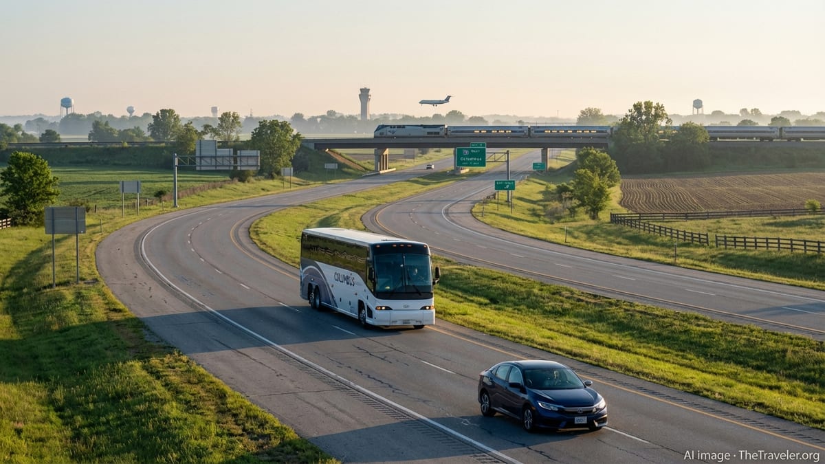
By mileage, driving still accounts for the majority of trips across Ohio. The state is threaded with major interstates including I 70 running east west through Columbus and Dayton, I 71 connecting Cincinnati, Columbus, and Cleveland, I 75 tracing the western edge through Cincinnati, Dayton, and Toledo, and I 80 and I 90 sharing the Ohio Turnpike across the north. For travelers, these roads mean that a daytime drive between the three C cities is often measured in three to four hour segments rather than long distance hauls.
Conditions along these corridors are generally predictable, but seasonal timing matters. Winters can bring lake effect snow to northern sections near Cleveland and Toledo and icy stretches along elevated overpasses statewide. Late fall and early spring often mean heavy rain that reduces visibility along wide open stretches of the Turnpike. Summer brings construction zones as the Ohio Department of Transportation works through resurfacing and bridge repair programs, which can add delays around metropolitan areas and river crossings. Building an extra buffer into your schedule is prudent, especially if your road leg needs to connect with a train or regional flight.
One advantage of traveling Ohio by car is the ease of detouring into small towns and park systems that sit off the mainline. The Hocking Hills region is reached most conveniently from Columbus by US 33, while Cuyahoga Valley National Park lies between Akron and Cleveland just off I 77 and I 271. Farther afield, you can cross the state diagonally from Cincinnati to Cleveland using a mix of interstates and local roads that roughly follow the completed sections of the Ohio to Erie Trail, giving a sense of the state’s river valleys, Amish country, and former canal towns that you would miss from a plane window.
When planning a car heavy itinerary, it is worth checking in advance for major bridge projects and urban freeway work. Ongoing investments in large structures, particularly around Columbus and Cincinnati, can result in long term lane closures and reroutes that apps will acknowledge but not fully explain. Pair your navigation tool with local traffic advisories and leave more time than you think you need when you are driving into or out of the three largest metros during weekday peaks.
Riding the Rails: Where Amtrak Fits Into an Ohio Trip
Passenger rail in Ohio is limited compared with some coastal states, but Amtrak still offers useful options for travelers willing to time their journeys carefully. The state is served by long distance trains that link Chicago with the East Coast. The Lake Shore Limited runs nightly between Chicago and New York or Boston with stops in northern Ohio, while the Cardinal connects Chicago and New York via Cincinnati several days each week. For residents of nearby states, these routes can serve as overnight bridges into Ohio or out toward coastal destinations.
Key Ohio stations for the Lake Shore Limited include Toledo’s Martin Luther King Jr Plaza and Cleveland’s lakefront station near downtown and the waterfront attractions. Both handle late night or early morning departures, so most travelers treat these legs as overnight rides, building in a quiet arrival day or a flexible checkout on the back end of the trip. Farther south, Cincinnati Union Terminal hosts the Cardinal line three days per week, also on a schedule that reaches the city in the overnight hours, which can be a tradeoff for budget minded travelers who are comfortable navigating at off times.
Because trains generally arrive and depart in the middle of the night in Ohio, your ground transportation plan matters. Both Toledo and Cleveland stations are within short rides of central hotels by taxi or rideshare, and in daylight hours are connected with local transit networks. Cincinnati’s terminal links with the city bus system, though the timing is not always aligned with train arrivals, so it is sensible to confirm late night or early morning transport in advance. Many travelers arrange for a hotel near the station and plan a slow morning after an overnight ride.
While intrastate rail options are still modest, future corridors are under study, including potential expansions that would better link Cleveland, Columbus, and Cincinnati by train. For now, the practical way to use Amtrak within Ohio is to combine it with other modes. A traveler might ride overnight from Chicago to Toledo, spend time exploring there or continue by car to Detroit or southern Michigan, or connect by intercity bus to Columbus and beyond. Similarly, a traveler from the East Coast could use the Lake Shore Limited to reach northern Ohio and then rent a car to explore lakefront communities or head south into Amish country.
Intercity Buses and Park and Ride Options
For travelers who prefer not to drive or who want to save on rental and fuel costs, Ohio’s intercity bus network has quietly become one of its most versatile assets. Traditional carriers such as Greyhound continue to serve major Ohio cities as part of national networks, but there has also been significant growth in state supported routes through the GoBus program and expanded offerings from companies like Barons Bus. These services often use full size coaches with reclining seats, restrooms, and Wi Fi, making them more comfortable than many people expect.
GoBus began as a way to connect rural and small town Ohio to larger urban centers, and recent expansions have extended that reach. New routes announced in late 2025 are designed to connect western and northern parts of the state, bringing communities such as Bowling Green, Fremont, Marion, Middletown, Oxford, Yellow Springs, and others into the intercity network. For travelers, this means cities that previously required a car can now sometimes be reached by pairing a regional flight or train with a bus leg, particularly for visits to university towns or smaller manufacturing centers.
In northern Ohio, Toledo’s Martin Luther King Jr Plaza functions as both rail and intercity bus hub, with Greyhound and Barons Bus using the facility to connect Toledo with cities across the region. In the Cleveland area, intercity bus operations that once centered on a downtown terminal have been shifting toward a new hub near the regional transit authority’s Brookpark station and close to Cleveland Hopkins International Airport. This kind of co location makes it easier to transfer between long distance buses, local rail, and flights, though it does require an additional local transit or rideshare leg to reach downtown Cleveland itself.
Many Ohio bus routes serve park and ride style stops, gas stations, and small transit centers along highways rather than large terminals alone. This can work in the traveler’s favor if you are driving part of the way and want to leave your car in a small town lot before continuing by coach, or if you are connecting from a local bus into the intercity network. It does, however, make trip planning more nuanced. Always check the exact stop location and consider daylight timing and amenities if you will have layovers, especially in rural locations where services may be limited outside standard business hours.
Regional Flights and Airport Choices
Air travel has rebounded strongly across Ohio, and regional flights now play a major role in how people move between the state and the rest of the country. Columbus, Cleveland, and Cincinnati are the largest air gateways, but Akron Canton, Dayton, and Toledo also support commercial service that can be valuable for certain itineraries. In 2025, Columbus airports handled record passenger numbers, surpassing pre pandemic levels with roughly 9 million plus travelers as airlines added more routes and frequencies. Cleveland Hopkins International likewise climbed back to around 10 million passengers a year.
For intra Ohio and short haul regional travel, it is less about flying between cities inside the state and more about using frequent flights to major hubs as bookends for ground travel. Columbus offers connections to a growing list of destinations including new links to Canadian and Florida airports. Cleveland provides coverage across the eastern United States and beyond, while Cincinnati’s airport just across the river in Kentucky remains an important hub for southern and midwestern connections. Akron Canton has seen notable growth with nearly 940,000 passengers in 2025, partly driven by new routes and expanded service from low cost carriers that appeal to price sensitive travelers.
Regional airports like Dayton and Toledo can be particularly useful if you are targeting specific corners of the state or nearby regions. Dayton offers convenient access to the Miami Valley and is an appealing entry point for those visiting the National Museum of the U.S. Air Force or following the aviation heritage trail. Toledo Express acts as a gateway to far northwest Ohio and southern Michigan. While flight options from these smaller fields can be more limited and subject to schedule changes, they may reduce your overall travel time when paired with a rental car and a focused itinerary.
When weighing flights against trains or long distance driving, look at total journey time rather than airborne minutes alone. A short flight might be less attractive once you account for airport transfers, security lines, and the need to arrive early, particularly on routes where interstate highways allow for steady high speed driving. On the other hand, flying into one city and out of another, then filling the gap with car, bus, or rail, can be an efficient way to cross Ohio while minimizing backtracking.
Designing a Multimodal Itinerary Across Ohio
One of the most effective ways to experience Ohio is to treat it as a set of linked corridors rather than a series of isolated cities. With that mindset, you can combine car, train, bus, and regional flights to maximize what you see while reducing repetitive backtracking. For instance, a traveler might begin with a flight into Cleveland, spend time exploring Lake Erie’s shoreline and nearby Cuyahoga Valley National Park by rental car, then continue west by Amtrak overnight to Chicago or east toward the East Coast, turning Ohio into a key chapter on a longer journey.
Another approach is to focus on the Columbus corridor. With strong air connections and its central location, Columbus works well as a starting and ending point for road loops. You could arrive by plane, pick up a car, and drive southeast to the Hocking Hills, then continue to Athens and other college towns along a GoBus corridor, leaving the car behind for a few days while you ride coaches between campuses and river towns. From there, you might loop back to Columbus by intercity bus and finish with a short drive to Dayton or Springfield before your flight home.
Travelers interested in arts and architecture might design a Cincinnati to Cleveland arc that uses a mix of modes. This could begin with a train journey on the Cardinal into Cincinnati for a night at Union Terminal, followed by a rental car drive northeast through Columbus and up to Cleveland, allowing time to visit neighborhoods, museums, and historic districts along the way. Alternatively, you could fly into Cincinnati, drive part of the route, then drop the car in Columbus and continue by bus or shared shuttle to Cleveland, where a final regional flight returns you home.
Whatever the combination, realistic timing is essential. Many long distance trains arrive overnight, some regional flights operate on limited schedules from smaller airports, and intercity buses in rural segments may only run a few times per day. Use current timetables and consider building in buffer days in cities where there is plenty to do in case weather or operational issues affect your connections. Multimodal travel rewards flexibility; if you end up with an unexpected day in Columbus, Cleveland, or Cincinnati, you will find no shortage of neighborhoods, parks, and attractions to fill the time.
Seasonal Tips, Safety, and Accessibility
Ohio’s four season climate shapes how comfortable and predictable different modes of travel will feel. In winter, snow and ice are the most obvious variables, especially along the Lake Erie shore and in elevated rural areas where winds can whip across open fields. Drivers should expect occasional advisories, slower traffic, and the possibility of whiteout conditions during lake effect events. Regional flights may be delayed or diverted during strong winter storms, particularly at smaller airports, and even long distance trains can be affected if freight traffic or weather disrupts the mainlines they share.
Spring and fall bring more moderate temperatures but also frequent rain and thunderstorms. These seasons can be pleasant for road trips if you keep an eye on the forecast and avoid driving through the heaviest cells. By contrast, summer offers the most stable conditions for long distance driving but also the greatest concentration of construction projects and weekend congestion near lakefront destinations and amusement parks. Buses and trains are generally less affected by seasonal traffic, though hot weather can still cause occasional slow orders on tracks and crowded conditions on popular routes.
Safety considerations mirror those elsewhere in the United States. Rest breaks are important on long drives, particularly along monotonous interstates. When using overnight trains or late night buses, keep valuables close and remain aware of your surroundings in stations and intermediate stops. Most Ohio intercity coaches and modern train cars are equipped with seat belts or other safety features, and it is wise to use them even when not required. For solo travelers or those unfamiliar with the region, staying near well lit stations and choosing central hotels or lodgings can add peace of mind.
Accessibility continues to improve across modes. Major airports such as Columbus, Cleveland, Cincinnati, and Akron Canton offer wheelchair accessible facilities and established procedures for travelers who need assistance through security and boarding. Amtrak stations in Toledo, Cleveland, and Cincinnati provide accessible platforms and station amenities, though boarding at night can still pose challenges for some travelers. Many GoBus and Barons coaches are equipped with lifts and reserved seating for passengers with reduced mobility, and local transit systems in larger Ohio cities maintain fleets with low floor buses and audible stop announcements. When accessibility is a priority, communicate your needs early with carriers and build extra time for transfers.
The Takeaway
Traveling across Ohio in 2026 is less about choosing a single best way to move and more about matching modes to routes. Driving remains the most flexible option for reaching remote parks, small river towns, and emerging neighborhoods, but rail, regional flights, and intercity coaches now play important supporting roles, especially for those who prefer not to spend long days behind the wheel. With record passenger numbers passing through Columbus and strong growth at airports like Akron Canton, air travel provides efficient bookends for ground based exploration.
Amtrak’s long distance lines offer overnight links that can extend an Ohio trip into a broader Midwest or East Coast journey, while the state supported GoBus network and private operators such as Barons Bus and Greyhound connect rural communities and college towns to the three C cities and beyond. Together, these systems allow you to stitch together itineraries that feel less like straightforward commutes and more like layered journeys through varied landscapes and communities.
For travelers willing to plan carefully, monitor seasonal conditions, and remain flexible with timing, Ohio rewards multimodal exploration. Flights can carry you quickly into the state’s gateways, trains can turn overnight hours into travel time, and buses and rental cars can close the gaps between airports, stations, and the quieter corners of the Buckeye State. By understanding how each mode works and where it excels, you can craft trips that are efficient, resilient, and rich in experience.
FAQ
Q1. Can I travel across Ohio without renting a car?
Yes, it is possible, especially between larger cities and some college towns, by combining Amtrak, GoBus and other intercity buses, local transit and regional flights.
Q2. Which Ohio cities have the best flight connections for regional travel?
Columbus, Cleveland and Cincinnati offer the widest range of routes, with additional options at Akron Canton, Dayton and Toledo for specific regional itineraries.
Q3. How useful is Amtrak for getting around inside Ohio?
Amtrak mainly serves overnight long distance routes through Toledo, Cleveland and Cincinnati, so it is most practical when paired with buses or cars for local travel.
Q4. Are intercity buses in Ohio comfortable for longer trips?
Many GoBus and Barons Bus coaches provide reclining seats, restrooms, power outlets and Wi Fi, making them reasonably comfortable for multi hour journeys across the state.
Q5. When is the best season to drive across Ohio?
Late spring through early fall usually offers the most predictable driving, though summer brings more construction, while winter driving can be affected by snow and ice.
Q6. How far in advance should I book regional flights within or to Ohio?
Booking several weeks ahead is generally wise, especially for peak holiday periods and popular routes, as smaller airports and low cost carriers can see fluctuating fares.
Q7. Are Ohio’s train and bus stations accessible for travelers with mobility needs?
Major Amtrak stations and many intercity bus stops provide accessible facilities or lifts, but travelers should confirm details and request assistance before departure.
Q8. Is it safe to arrive at Ohio train stations late at night?
Many travelers use overnight trains without issues, but it is sensible to arrange transport in advance, keep belongings close and choose well reviewed, central accommodations.
Q9. Can I combine biking with car, train or bus travel in Ohio?
Yes, some travelers bring bikes on cars, certain buses or trains to access trails such as segments of the Ohio to Erie Trail, though carriage rules vary by carrier.
Q10. How should I decide between driving and flying for an Ohio trip?
Compare total travel time, costs and flexibility; for short to medium routes, driving is often faster door to door, while flights are better for long distances or one way itineraries.