
More news on this day
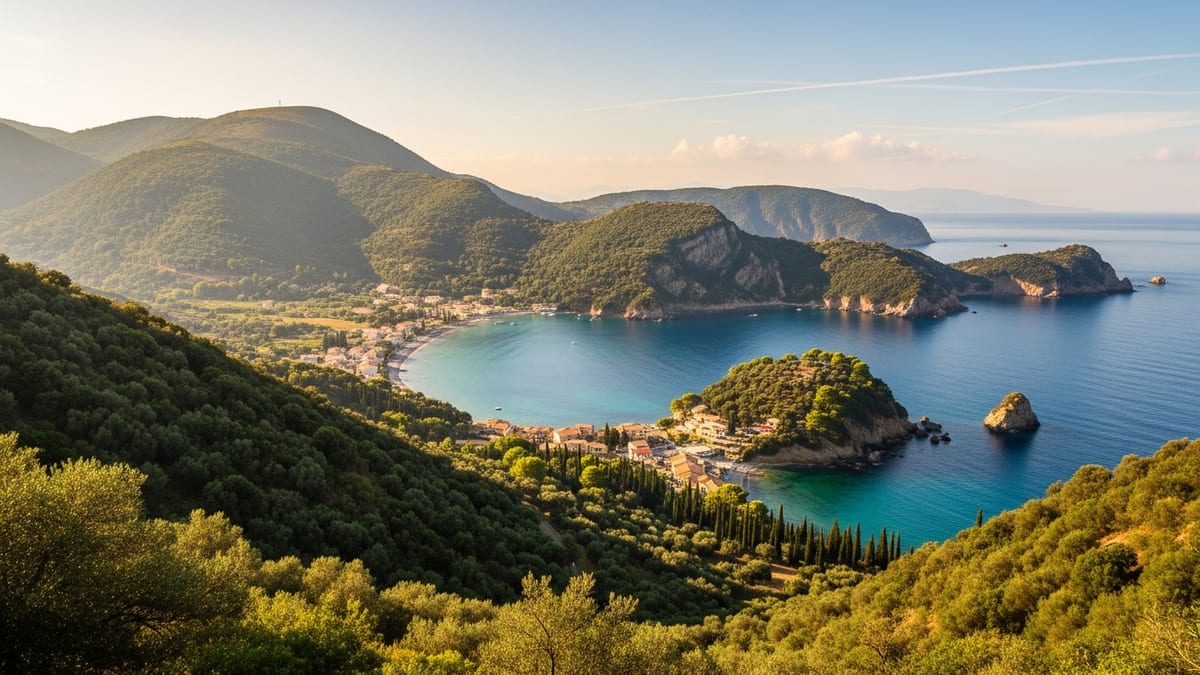
On a quiet corner of County Wexford’s Hook Peninsula, Baginbun Beach is emerging as a standout coastal retreat, where soft golden sand shares the shoreline with one of Ireland’s most consequential historic landing sites.
Get the latest news straight to your inbox!
A Sheltered Cove on Ireland’s Sunny Southeast Coast
Baginbun Beach lies near Fethard-on-Sea in County Wexford, facing the Celtic Sea on the eastern flank of the Hook Peninsula. Publicly available tourism information describes it as a compact sandy cove framed by low cliffs, with calm, relatively gentle waters that contrast with the Atlantic swell found on Ireland’s western seaboard. Recent visitor guides and travel reviews characterize the beach as quiet and family friendly, with an atmosphere that feels removed from busier resort-style strips elsewhere in Europe.
The cove’s shape and surrounding cliffs help to shelter bathers from prevailing winds, creating what regional promotions have long described as part of Ireland’s “sunny southeast.” Discover Ireland and independent travel sites note that the beach is especially popular in settled weather, when the golden sand and clear shallows make paddling and informal swimming attractive to visitors who might otherwise head for larger strands along the Wexford coastline.
Access remains relatively low key. A narrow rural road leads to a small, rough-surfaced parking area above the beach, and a slipway-style path descends to the sand. Outdoor swimming guides published in April 2026 highlight that the track can be uneven and that the beach is not wheelchair accessible, underlining that Baginbun still functions more as a natural cove than as a heavily developed resort with extensive infrastructure.
Despite the modest facilities, Baginbun’s reputation among day trippers has grown. Recent crowd-sourced reviews describe clean sand and water, seasonal lifeguard presence in peak summer, and simple amenities such as public toilets and an outdoor hose or shower point near the car park where visitors can wash off sand before leaving.
Where “Ireland Was Lost and Won”
Beyond its appeal as a sheltered swimming spot, Baginbun occupies an outsized place in Irish history. Heritage material compiled for the Norman Way trail and Wexford’s local history initiatives points to the beach and the adjoining headland as the landing site for a small force of Anglo Norman soldiers in May 1170. Commanded by Raymond le Gros, these troops established a fortified camp on the heights above the cove, securing a foothold that would shape centuries of political change.
The site is closely associated with the couplet “By the creek of Baginbun, Ireland was lost and won,” a line repeated in guidebooks, local interpretive panels and media coverage of the area’s heritage disputes. Whether or not the phrase dates from the medieval period, it has come to encapsulate the sense that Baginbun marked a turning point when Norman power became firmly established on Irish soil.
Remnants of earthworks and overgrown fortifications survive on the headland, although much of the upper ground is in private ownership. Regional news reports in recent years have covered local concern over access to parts of Baginbun Head, reflecting wider debates across rural Ireland about coastal paths, rights of way and the balance between private property and public enjoyment of historic landscapes. For visitors, the beach itself remains freely accessible, while the story of the 1170 landing is increasingly presented through off-site interpretation, digital content and the broader Norman Way narrative.
Standing on the sand today, bathers share space with this layered past. The view across the small bay, with a 19th century Martello tower visible on the southern side, links successive eras of coastal defense, from Norman ramparts to Napoleonic-era watchtowers and modern heritage branding under the Ireland’s Ancient East banner.
Part of Ireland’s Ancient East and the Norman Way
Baginbun Beach now figures prominently in Ireland’s Ancient East, the national tourism brand launched to showcase historic sites across the eastern and southeastern counties. Within that framework, Wexford’s coastal landmarks form a strand of stories focused on medieval and Anglo Norman Ireland, complementing better known attractions such as nearby Hook Lighthouse and the heritage town of New Ross.
The Norman Way, a themed driving and cycling route promoted by local authorities and national tourism agencies, links Baginbun with other key sites including Bannow Bay, Tintern Abbey and a series of tower houses and castles along the Wexford shoreline. Interpretive material encourages visitors to move beyond individual monuments and view the coast as a connected Norman frontier, in which Baginbun Beach serves as the landfall that set later developments in motion.
Recent brochures and online guides present Baginbun as a place where this history can be experienced at a human scale. Unlike fortified towns or restored castles, the beach offers a largely unchanged natural setting, inviting visitors to imagine ships edging into the cove beneath low cliffs more than 850 years ago. The combination of everyday seaside activity and deep historical resonance aligns closely with the wider Ireland’s Ancient East strategy, which seeks to blend landscape, legend and accessible storytelling.
For local communities on the Hook Peninsula, the increased visibility of Baginbun within these campaigns has brought opportunities and challenges. Small hospitality businesses in nearby Fethard-on-Sea benefit from the added footfall, while planners and environmental assessments monitor how car access, proposed infrastructure projects and coastal erosion might affect both the beach environment and the archaeological resource around the headland.
A Quiet Alternative to Busier Coastal Hotspots
As overseas travel rebounds and Irish domestic tourism continues to prioritize outdoor experiences, Baginbun stands out as a quieter alternative to more crowded strands. Travel commentators often describe the cove as a place for picnics, sandcastle building and sea swimming rather than organized water sports or nightlife, positioning it firmly in the “slow travel” category.
Beach guides updated in 2024 and 2025 portray Baginbun as “small but spectacular,” noting that its size can mean the car park fills quickly on very warm days, yet overall visitor numbers remain modest compared with long, open beaches elsewhere in County Wexford. Families are drawn by the shallow gradient of the sand and the protection from prevailing winds, while walkers often combine a visit with longer drives along the Hook Peninsula or stops at nearby historical attractions.
Safety information shared by outdoor swimming platforms emphasizes the importance of checking local conditions, including weather and tides, before entering the water, but generally describes Baginbun as suitable for confident paddlers and recreational swimmers when seas are calm. The naturally sheltered shape of the bay contributes to an impression of tranquility that many visitors seek out specifically when choosing the southeast over more dramatic Atlantic locations.
Because commercial development around the cove remains limited, the sensory experience at Baginbun is dominated by coastal sounds rather than traffic or built-up resort noise. The rhythmic wash of small waves, the calls of seabirds nesting along the cliffs and wide open views toward the horizon underpin its reputation as an understated retreat, drawing repeat visitors who value a low-key, historically rich shoreline.
Balancing Heritage, Ecology and Escape
Baginbun’s growing profile also highlights the need to manage a sensitive stretch of coast where geology, biodiversity and cultural heritage intersect. Geological surveys conducted for County Wexford identify the rocks exposed along the northern side of Baginbun Head as a site of special interest, while environmental impact assessments for regional infrastructure projects have examined how any landfall works in the area might affect protected habitats within the broader Hook Head conservation zone.
These technical documents sit alongside tourism campaigns that foreground the bay’s golden sand and clear water, illustrating the tension between presenting Baginbun as a carefree holiday spot and recognizing its environmental and archaeological significance. Publicly available planning and heritage reports encourage visitors to keep to established paths, respect signage around private land on the headland and leave the beach as they found it to protect both wildlife and historic features.
The debate over access to the headland, covered periodically in regional newspapers, has drawn attention to how treasured Baginbun has become for local walkers as well as visitors from further afield. While formal rights of way are contested in places, the beach itself remains a shared space, symbolizing a middle ground where history, leisure and conservation can coexist when managed carefully.
For now, Baginbun Beach continues to offer a rare combination of intimate cove, pivotal Norman landing site and relatively undeveloped escape on Ireland’s southeastern coast. As travel patterns evolve and coastal management policies adapt, its quiet golden sands are likely to remain a touchstone in discussions about how Ireland balances tourism growth with the protection of its most storied shorelines.