
More news on this day
Bangkok’s latest generation of city maps reflects a capital in motion, layering new metro lines, walking routes and digital platforms onto one of Asia’s most complex urban landscapes.
Get the latest news straight to your inbox!
Rail expansion redraws the mental map of Bangkok
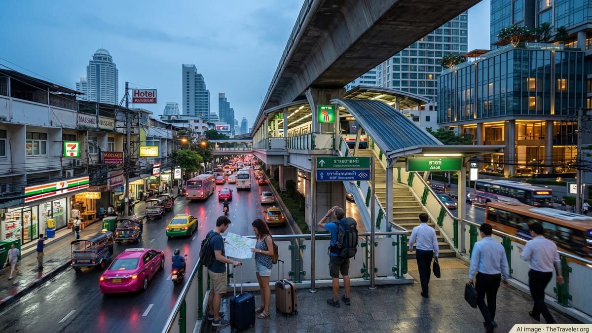
Bangkok’s rail network has become the backbone of most current city maps, as new and extended lines shift how visitors understand distance and time across the Thai capital. Recent public transport maps highlight an integrated system that now includes the BTS Skytrain, multiple MRT metro lines and newer routes such as the Yellow and Pink lines, which have expanded coverage into eastern and northern districts. These diagrams increasingly serve as the primary reference for travelers planning where to stay and which neighborhoods feel realistically “close” to the historic core or major shopping areas.
Reports indicate that construction of the MRT Orange Line, running broadly east to west and interchanging with existing lines at Thailand Cultural Centre, is progressing and is being factored into forward-looking transit maps, even before full opening. Coverage of transport projects in Thai media suggests that key sections of the western Orange Line remain under construction, while privately produced rail maps already show the future link as a critical crosstown corridor. For travelers, this means that maps dated only a few years ago may understate how quickly rail access is improving in outlying areas.
Privately compiled transit diagrams and editorial atlases now tend to present Bangkok less as a single congested core and more as a constellation of hubs strung along rail corridors. Interchange stations such as Asok, Siam and Bang Wa feature prominently as anchor points, reflecting their real-world role as gateways between older road-based districts and rail-linked suburbs. The result is a conceptual shift in which a “central” Bangkok is no longer just the historic Rattanakosin Island or riverside, but a wider, rail-defined urban spine.
Interactive city maps blend transit, neighborhoods and lifestyle data
Alongside traditional schematic maps, a wave of interactive platforms is changing how visitors explore Bangkok at street level. Editorial atlases focused on the capital now combine three-dimensional mapping with curated points of interest, from temples and markets to rooftop bars and condominium clusters. Publicly available descriptions of these platforms show that they are often structured around neighborhoods rather than isolated attractions, helping newcomers see how sightseeing areas, nightlife streets and residential zones connect to specific train stations.
These interactive maps typically integrate BTS and MRT lines as a base layer, then overlay lifestyle-focused categories such as food streets, café districts or viewpoints. Instead of treating the city as a checklist of famous sights, the tools encourage visitors to compare areas like Sukhumvit, Ari, Chinatown and the Old Town as distinct urban “villages,” each with its own density, walkability and transit access. This approach is influencing how travel media explain the city, with more guides now framing hotel and restaurant choices by proximity to specific stations rather than by broad, sometimes vague district names.
Map interfaces increasingly include “near me” search functions and filters that allow users to highlight only certain types of venues, from street food to co-working spaces. For travelers, that means the classic paper city map, once focused mainly on monuments and a few central roads, is being replaced by dynamic views that change with the time of day and personal interests. The digital layering of transit, amenities and neighborhood character is making it easier to navigate beyond long-established tourist corridors.
Walking maps push beyond Bangkok’s traffic-heavy image
Bangkok’s reputation for heavy traffic often shapes outsider perceptions of how hard the city is to explore on foot. In response, a growing number of walking maps are promoting compact, walkable districts, especially around the Old Town and riverside. Tourism-focused coverage of these routes describes circuits that link temples, markets and historic lanes into half-day itineraries, supported by printable maps and simple schematic diagrams showing key junctions and pier connections.
Old Town walking maps typically cluster sites around Rattanakosin Island, including major temple complexes and viewpoints along the Chao Phraya River. Many of these maps highlight short ferry hops and canal-side paths, reflecting how water transport still shapes the city’s layout. They encourage visitors to think in terms of contiguous, walkable precincts rather than isolated, taxi-dependent stops, even if walks are often bracketed by train or boat rides at the beginning and end.
Elsewhere, riverside walks and neighborhood-level maps in areas like Talat Noi, Chinatown and Banglamphu showcase alleys, small shrines and local food stalls that rarely appear on standard tourist diagrams. These hyperlocal maps aim to distribute visitor foot traffic more evenly, steering some travelers away from only the busiest landmarks and into side streets where traditional shop houses and community markets remain active. For urban planners and tourism officials, such mapping efforts are also seen as a way to spotlight cultural heritage that might otherwise be overshadowed by new malls and transport hubs.
Official digital platforms and smart-city initiatives shape wayfinding
Bangkok’s municipal authorities and national agencies are also moving to formalize digital city mapping through official platforms. Public information indicates that an initiative branded as an official gateway for visiting Bangkok was launched in early 2026, offering curated neighborhood profiles, suggested routes and seasonal highlights. Although details continue to evolve, the project reflects a broader trend in which public-sector tourism promotion is shifting from static brochures toward real-time, map-led trip planning tools.
Smart-city strategies at the national level reference integrated mapping, open data and improved transport information as core components for Bangkok and other major Thai destinations. These programs emphasize seamless connections between modes, such as rail, buses and river boats, alongside digital payment and journey-planning features tied directly into mobile maps. As these systems mature, visitors are expected to rely less on standalone transit diagrams and more on city maps that combine live service information with location-aware recommendations.
In practical terms, this means that future Bangkok city maps are likely to show not only where lines and piers are but when services run frequently enough to be viable alternatives to taxis and ride-hailing. Real-time overlays, including crowding indicators and disruption alerts, are being discussed in policy documents and pilot programs. When fully implemented, such features could significantly change how travelers decide between modes at busy junctions, especially during peak hours or heavy rain.
From paper souvenirs to predictive tools for trip planning
Despite the shift toward digital platforms, printed maps of Bangkok remain present in hotels, transit stations and visitor centers. Many newer editions feature simplified rail diagrams on one side and neighborhood blow-ups on the other, recognizing that travelers often need both a citywide overview and close-up detail around key districts. These maps increasingly include grids tied to rail stations, making it easier to translate between schematic transit views and the more organic, river-and-canal-based street pattern.
At the same time, smartphone-based city maps are turning into predictive planning tools rather than passive references. By drawing on published data about new rail openings, service frequencies and changing land use, digital maps can suggest not only how to reach a destination today but which areas are becoming more accessible in the near future. For visitors returning to Bangkok after several years, this can alter long-held assumptions about which neighborhoods feel “far” from the center.
The convergence of expanded rail infrastructure, interactive atlases, themed walking maps and smart-city platforms is gradually rewriting Bangkok’s mental map for both locals and international travelers. Instead of a city defined solely by traffic-choked roads, the latest mapping tools present a more nuanced picture of a metropolis divided into rail-linked hubs, walkable heritage districts and emerging neighborhoods where new lines and digital services are quietly reshaping how the city is experienced on the ground.