
On paper, the Navajo Loop Trail in Bryce Canyon National Park looks deceptively simple: roughly 1.3 miles, rated moderate, and advertised as one of the park’s signature hikes. In reality, this short loop packs in steep switchbacks, high elevation, intense sun, variable seasonal closures, and some of the most crowded viewpoints in the park. Many visitors step onto the trail from Sunset Point expecting a casual stroll and end the hike red-faced, winded, or frustrated that they missed Bryce’s best viewpoints or walked it in the most punishing conditions of the day. If you are planning to tackle the Navajo Loop, here are the key things travelers consistently say they wish they had known before setting foot between the hoodoos.
Get the latest updates straight to your inbox!
Understand the Trail’s Real Difficulty, Not Just the Mileage
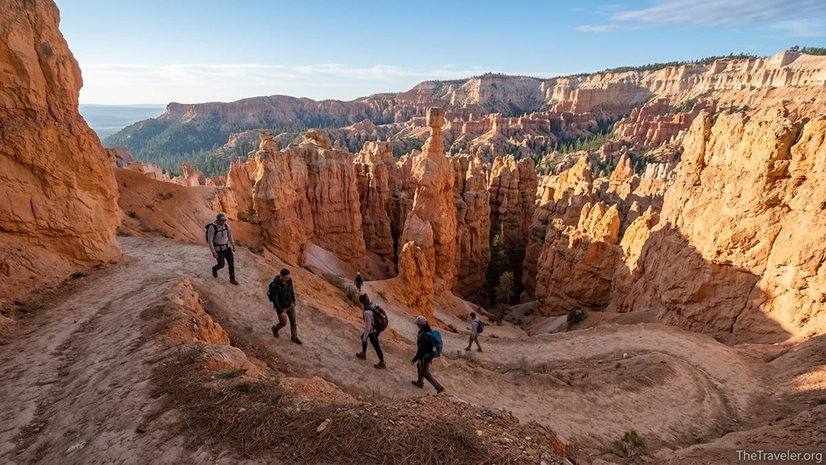
The Navajo Loop Trail begins and ends at Sunset Point, dropping from the rim of Bryce Amphitheater into a maze of orange and pink hoodoos. The loop is only about 1.3 miles long, with an elevation change of roughly 500 to 550 feet, but nearly all of that elevation is lost and regained in a compact stretch of steep switchbacks. Many visitors see the short distance and assume it will be an easy add-on between scenic overlooks, only to discover that the climb back to the rim feels more like a stair workout than a leisurely walk.
Part of the challenge is elevation. Sunset Point sits at around 8,000 feet above sea level. Travelers coming straight from low-altitude cities like Los Angeles or Orlando often notice that they are breathing harder much earlier than they would on a similar hill at home. One common story from rangers and visitors alike is of families from the Midwest who march down the trail in sandals without water, then struggle for 40 minutes to climb the last set of dusty switchbacks in the hot afternoon sun, stopping every few steps to catch their breath.
The direction you hike also matters. The loop forms a rough "Y" shape, with one side known as Wall Street and the other as Two Bridges. When conditions allow the full loop, many experienced hikers prefer to descend the steeper Wall Street side and climb out via the somewhat more gradual Two Bridges side, or combine Navajo with the Queen’s Garden Trail and use Navajo as the exit climb. Newer hikers who drop quickly down Navajo and then attempt to climb out the same way often find the sustained grade surprisingly taxing, especially if they started late in the day.
If you are unsure about your fitness, plan to treat Navajo Loop as your primary hike, not an afterthought squeezed in after hours of sightseeing. Give yourself at least 1.5 to 2 hours, move slowly, and remember that standing in line for photos at switchbacks or Thor’s Hammer still counts as time on your feet at altitude.
Seasonal Closures and Conditions Can Change Your Route
One of the most frequent surprises for first-time visitors is discovering that half of the Navajo Loop may be closed when they arrive. The Wall Street side in particular is often closed in winter and shoulder seasons due to rockfall risk, ice, and freeze-thaw conditions. When that happens, the trail remains open as an out-and-back down and up the Two Bridges side, but the classic experience of walking a full loop through the slot-like corridor of Wall Street is not available.
Even outside of winter, heavy thunderstorms, late spring snow, or mudslides can force temporary closures with little warning. For example, in recent seasons, early spring storms have triggered mudslides that shut down sections of Navajo Loop for days or weeks while crews cleared debris and repaired switchbacks. Travelers who built their entire Bryce Canyon day around hiking Wall Street have found themselves turning around at closure signs just a few hundred yards below Sunset Point.
The park’s printed summer newspaper and onsite signage at the visitor center and Sunset Point are the most reliable same-day sources for information on closures, reroutes, and trail conditions. AllTrails and social media posts can be helpful to gauge recent experiences but are often out of date by a few days, which matters when a rainstorm rolls through. A common pattern is seeing a review from two weeks earlier raving that Wall Street is open, only to arrive and find the gate locked due to overnight ice.
If you are visiting in late fall, winter, or early spring, mentally plan for the possibility that you may hike Navajo as an out-and-back or choose an alternate route such as the Queen’s Garden Trail as your main hike. Build flexibility into your itinerary so a closure feels like a change of plan rather than a ruined day.
Timing Your Hike: Light, Crowds, and Weather
Because the Navajo Loop Trail starts right at Sunset Point, it collects crowds the way a city subway platform fills at rush hour. Buses arrive, tour groups step to the rim, and a steady stream of visitors pours onto the trail. By late morning in peak season, you can find yourself shuffling slowly down narrow switchbacks, waiting for dozens of people to snag their perfect photo of the zigzag path or the narrow Wall Street corridor.
Early morning is the single most valuable crowd-avoidance tactic. Reaching Sunset Point shortly after sunrise typically means cooler air, softer light on the hoodoos, and far fewer people clogging the switchbacks. In July or August, starting by 7:00 a.m. can make the difference between hiking in 60-degree air or sweating in direct sun with temperatures climbing toward the 80s or 90s. As a bonus, park shuttles that stop at Sunset Point usually start running by mid-morning, so arriving by car earlier lets you find parking in the lot instead of circling or parking farther away along the road.
Time of day also shapes your experience with the landscape. In early morning or late afternoon, the low sun angle throws long shadows across the hoodoos and outlines formations like Thor’s Hammer and the Silent City with dramatic contrast that still feels natural. Midday light, especially around noon, tends to be harsher and flattens the sculpted detail in the rock. Many photographers planning a single hike try to time the lower canyon floor portion of the loop for mid- to late morning, when the sun is high enough to illuminate the narrow walls without blasting them with overhead glare.
Weather is more variable than many visitors expect. Bryce Canyon sits at high elevation on the Paunsaugunt Plateau, so temperatures can swing sharply between chilly mornings and warm afternoons. In June, it is common to start the trail in a light jacket in 45-degree air and finish in a t-shirt under strong sun. Monsoon season, roughly July through early September, often brings afternoon thunderstorms, lightning, and brief but intense downpours. Starting your hike in the morning reduces exposure to storms and slippery surfaces on the steepest sections.
Route Choices: Navajo Alone or in Combination Loops
Another surprise for many first-time hikers is how many variations exist on the basic Navajo Loop experience. The most famous option is the combination with Queen’s Garden, often described by guides and travel sites as the best short hike in the park. That route generally starts at Sunrise Point, descends the Queen’s Garden Trail among whimsical hoodoos, crosses the canyon floor, then climbs back up via the Navajo Loop to Sunset Point, before following the flat Rim Trail between the two viewpoints.
For visitors who are moderately fit and have 2 to 3 hours, this Queen’s Garden plus Navajo combination offers a more complete sense of the amphitheater than hiking Navajo alone. You spend more time among the formations at the canyon floor, see Bryce’s famous “Queens” hoodoo, and still experience Navajo’s tight switchbacks and views of Thor’s Hammer. Travelers who choose this loop often comment afterward that they are glad they invested a bit more time rather than doing several short, disconnected walks from the rim.
Stronger hikers with half a day sometimes extend their route into the Figure-8 Combination, which links Navajo, Queen’s Garden, and the Peekaboo Loop for a much longer and more strenuous experience. This involves additional elevation change and exposes you more fully to sun and weather. It is a rewarding extension but not something to attempt casually at midday in summer with limited water. An all-too-common story is of visitors starting the Figure-8 around noon, running low on water halfway through Peekaboo, and trudging the last climb in direct sun.
If your time is limited or you are traveling with young children or older relatives, hiking only the Two Bridges side of Navajo out-and-back is still worthwhile. You will see the signature switchbacks, tall Douglas fir trees in the lower canyon, and iconic hoodoo formations. This shorter option can work well if you are driving through Bryce on the same day you plan to reach Zion or another destination and need to keep your hike under an hour.
What to Wear and Bring (That Many People Forget)
On summer days, it is common to see crowds starting down Navajo Loop in flip-flops, fashion sneakers with smooth soles, or flat sandals. The trail surface is a mix of hard-packed dirt and loose dust-covered gravel, and both the descent and ascent involve tight turns where your footing matters. Closed-toe hiking shoes or trail runners with decent tread are strongly recommended. Even budget-friendly trail runners from major brands sold in outdoor shops at home are far more secure than casual street shoes or worn-out gym sneakers.
Water is the single most overlooked item on this trail. Because the hike is short, many visitors leave their bottles in the car or bring a single small bottle to share between two people. At Bryce’s altitude and in its dry, windy climate, you lose moisture quickly without noticing. A rough guideline that many outdoor educators suggest is at least one liter of water per person for a hike of this length at altitude in summer, more if you tend to sweat heavily or plan to continue to other trails. Lightweight reusable bottles or a small hydration bladder fit easily in a simple daypack or sling bag.
Sun protection is critical. The upper portion of the trail near Sunset Point and the climb back to the rim are highly exposed. Visitors who set out mid-morning without hats or sunscreen often finish the loop with flushed faces and sunburned necks, even on days that feel cool. A wide-brimmed sun hat or cap, sunglasses, and a broad-spectrum sunscreen applied before you start and carried in a small tube for reapplication are straightforward defenses. In shoulder seasons, when the air feels cool, it is especially easy to underestimate the sun at altitude.
Layering matters in all but the hottest months. In May or September, a light fleece or synthetic mid-layer over a sweat-wicking T-shirt can keep you warm while you stand at the rim, then tie easily around your waist or stow in a pack when you warm up on the climb. In winter, traction devices such as microspikes are often recommended for icy sections, although you should always check how much ice is on the steepest switchbacks and decide based on your comfort level and current conditions.
Safety, Etiquette, and Photography Pitfalls
Because Navajo Loop is so photogenic, it is also a magnet for risky behavior in pursuit of memorable images. One of the most common scenes is visitors stepping over low rock borders or edging dangerously close to drop-offs along the rim and switchbacks for a shot without other people in the background. These edges are often undercut, and the soft rock can crumble unexpectedly. Rangers regularly report near-misses where someone slips on loose dirt at the edge of a drop while backing up for a photo.
Staying on the established trail and inside railings and rock borders is not only safer but also protects the fragile soil and plants that cling to the canyon walls. When the trail narrows on switchbacks, especially in Wall Street, it helps to keep single file, step to the side briefly for uphill hikers, and avoid stopping in the tightest spots for extended photo shoots. A good rule many hikers follow is to take quick photos while moving and save longer poses for wider sections or the base of the canyon, where there is more space to step aside.
Navajo Loop is also a shared space with occasional stock use on connecting trails, so you may encounter horse or mule groups if you link into Peekaboo or other routes. Standard practice is to yield to animals by stepping to the inside of the trail, listening to the guide’s instructions, and giving them calm, quiet passage. Even if you see only hikers on Navajo itself, being aware of this etiquette helps if you extend your route.
Another overlooked issue is altitude and pre-existing health conditions. Visitors with heart or lung conditions, or those recovering from illness, sometimes underestimate how hard the climb will feel. If you start to feel dizzy, extremely short of breath, or experience chest pain, stop, rest in the shade if possible, and do not hesitate to turn around or ask a companion to alert a ranger. Cell coverage around the rim is patchy but often sufficient at Sunset Point to reach emergency services if needed.
Logistics: Parking, Shuttles, and Fees
Bryce Canyon National Park charges an entrance fee that covers vehicle access for several days. This fee is separate from any camping or lodging costs and applies whether you plan to hike Navajo Loop or simply enjoy the overlooks. If you hold an America the Beautiful annual pass, that will cover entry. Many first-time visitors are surprised at the time it takes to pay at the entrance station and then drive to parking during busy hours, so building in extra transit time is wise, particularly if you are trying to start Navajo early.
Parking at Sunset Point fills quickly in peak season, often by late morning. The park’s free shuttle system generally operates from spring through fall, stopping at popular trailheads including Sunset and Sunrise Points. A common strategy is to park at the main visitor center or in designated parking farther from the rim, then ride the shuttle to Sunset Point for the start of your hike. This avoids circling the lots and allows you to focus on timing your hike with the best light rather than worrying about finding a space.
Families doing the Queen’s Garden plus Navajo combination often park once at Sunrise or near the visitor center, hike from Sunrise to Sunset, then ride the shuttle back. This creates a pleasant one-way experience without retracing steps along the rim. It also reduces confusion over where you left the car after an early start and a long morning on the trail.
There are no services directly on the Navajo Loop Trail itself. Restrooms and water taps are available near the parking areas and viewpoint, but once you pass the trailhead sign and begin your descent, you should not expect bathrooms, trash cans, or water fountains. Pack out all litter, including tissues and fruit peels, and plan restroom breaks before or after your hike.
The Takeaway
For many visitors, the Navajo Loop Trail becomes the defining memory of their time at Bryce Canyon. The tight switchbacks coiling through orange rock, the towering Douglas firs improbably rooted in the canyon floor, and the view back up toward Thor’s Hammer and the rim are unlike any other short hike in the American Southwest. Those who enjoy it most tend to be the ones who treat it as a real hike rather than a casual stroll: they start early, bring water, wear appropriate shoes, and check current conditions before they go.
If you go in expecting a steep climb at high altitude, variable trail conditions, and heavy doses of sun and crowds during the middle of the day, the reality will likely feel more manageable. Combine the loop with Queen’s Garden if your time and fitness allow, or savor Navajo on its own and linger at Sunset and Sunrise Points afterward. With a bit of preparation and realistic expectations, you can experience the best of Bryce’s iconic amphitheater while staying safe, comfortable, and fully present in one of Utah’s most striking landscapes.
FAQ
Q1. How long does it take to hike the Navajo Loop Trail?
Most visitors take about 1 to 2 hours to complete the Navajo Loop, depending on fitness, photo stops, and whether they encounter congestion on the switchbacks.
Q2. Is the Navajo Loop Trail suitable for beginners?
Yes, many beginners hike Navajo Loop, but it feels challenging because of the steep climb at high elevation. Go slowly, bring water, and be prepared to rest.
Q3. Which direction should I hike the Navajo Loop?
When the full loop is open, many hikers prefer to descend the steeper Wall Street side and climb up via Two Bridges or use Navajo as the exit on the Queen’s Garden plus Navajo combination.
Q4. When is the best time of day to hike the Navajo Loop?
Early morning is ideal for cooler temperatures, softer light, and fewer crowds. Late afternoon can also be pleasant, but afternoon storms are more common in midsummer.
Q5. What should I wear on the Navajo Loop Trail?
Wear closed-toe hiking shoes or trail runners with good tread, comfortable layers suitable for changing temperatures, and a hat and sunglasses for sun protection.
Q6. Do I need to bring water for such a short hike?
Yes. The trail is steep and exposed, and the air is dry at high elevation. Aim for at least one liter of water per person, even if you are only hiking Navajo Loop.
Q7. Is the Wall Street section always open?
No. Wall Street often closes in winter and during periods of ice, rockfall, or recent storms. Check signs at the visitor center or Sunset Point for the latest status before hiking.
Q8. Can children or older adults hike the Navajo Loop?
Many families and older adults successfully complete the trail. Plan extra time, consider hiking only part of the loop if needed, and allow frequent breaks on the climb.
Q9. Are trekking poles useful on this trail?
Trekking poles are optional but helpful, especially on the steep, dusty switchbacks. They provide extra stability on the descent and support on the climb back to the rim.
Q10. Is a permit required to hike the Navajo Loop?
No special permit is required for the Navajo Loop Trail itself, but you must pay the standard Bryce Canyon National Park entrance fee or use a valid annual park pass.