


There are national park views you admire from a distance, and then there are landscapes you only truly understand once you have walked right into the middle of them. For me, Bryce Canyon’s famed hoodoos did not fully come alive until I dropped below the rim on the Navajo Loop Trail and felt those orange spires closing in around me. Descending into that maze of rock was the highlight of my visit, and it is the experience I now measure other hikes against.
Get the latest updates straight to your inbox!
Meeting Bryce Canyon at Sunrise
I arrived at Bryce Canyon National Park in the blue-gray hush before sunrise, when the amphitheater still felt like a secret. The free seasonal park shuttle dropped me at Sunrise Point after a ten-minute ride from the main parking and shuttle station just outside the entrance. Using the shuttle instead of hunting for a space near the rim turned out to be one of the best decisions of the day, especially as I watched the lots around Sunset Point fill up rapidly later in the morning.
At the railing by Sunrise Point, the hoodoos were a jagged silhouette backed by a pale band of light. As the sun eased above the distant Kaiparowits Plateau, the formations shifted from dull rust to a layered palette of peach, apricot, and glowing white. The famous Bryce colors looked like they had been dialed up a notch compared with the photos I had seen, but the air was cold enough that my fingers ached on the metal rail. At over 8,000 feet of elevation, even late spring mornings can be barely above freezing, something first-time visitors often underestimate when they pack only desert-heat clothing for a Southwest road trip.
From that vantage point, it was easy to see why many people never leave the rim. The view feels complete, as if the whole story of Bryce is written in that vast bowl of hoodoos stretching toward Sunset Point and Inspiration Point. But the longer I watched tiny figures moving along the switchbacks below the rim, the more obvious it became that the real experience was down there, threading between those stone towers.
By the time the sun cleared the horizon, the first tour buses were unloading near the lodge and the shuttle loop had grown busier. I took that as my cue, zipped up my jacket against the lingering chill, and started walking the gently sloping Rim Trail toward Sunset Point, where the Navajo Loop begins.
Stepping Off the Rim Toward the Navajo Loop
The half-mile stroll from Sunrise to Sunset Point is a useful warm-up for the hike to come. The path is paved and essentially flat, lined with junipers and limber pines twisted into improbable shapes by winter storms. To my right, the Bryce Amphitheater opened and closed in varying angles, revealing new clusters of hoodoos with every bend. Families with strollers and older travelers with trekking poles shared the same walkway, all headed toward some combination of the Queen’s Garden, Navajo Loop, or Rim Trail viewpoints.
At Sunset Point, the mood shifted. The broad overlook felt like a busy train station for hikers, with groups sorting out water bottles, tightening boot laces, and debating whether to tackle the loop or simply enjoy the overlook. A large trail sign laid out the options in simple terms: down the Navajo Loop and up the same way, connect it with Queen’s Garden for a longer combination, or stick to the rim and avoid the steep descent entirely.
The official trail mileage for the Navajo Loop on its own is around 1.3 to 1.5 miles, depending on conditions and which side of the loop is open. On paper that sounds trivial. The park service, and every ranger I spoke to, is quick to point out that the real challenge is the roughly 550 to 600 feet of elevation loss and gain packed into a compact series of switchbacks. The warnings on the sign about loose surfaces, altitude, and summer heat may feel dramatic at eight in the morning, but they are there for a reason.
When I visited, the classic Wall Street side of the Navajo Loop was open, but there was still evidence of why it often closes for much of the winter and spring. Patches of shaded trail held onto icy grit and the rangers had posted clear notices at the visitor center about potential mud and rockfall lower down. In some recent seasons, heavy storms have triggered mudslides and debris flows that temporarily closed not just Wall Street but at times the entire Navajo Loop. Planning a Bryce itinerary around this hike means checking the current status in person or with park information before you arrive, and being prepared with alternate below-the-rim options like the Queen’s Garden out-and-back or the Peekaboo Loop from Bryce Point.
The First Switchbacks: Dropping Into Hoodoo Country
The upper section of the Navajo Loop wastes no time in introducing you to the verticality of Bryce. From the overlook, the trail dives away in a series of dusty, well-defined switchbacks cut into the slope beneath the famous Thor’s Hammer hoodoo. Within minutes of leaving the railing I could feel my perspective changing. The amphitheater that had seemed like a single continuous scene from the rim broke apart into individual finned ridges and clusters of columns, each with different layers of pink, salmon, and cream-colored limestone.
Even though the descent is the easier half of the hike physically, it demands attention. Loose gravel gathers at the edges of each turn, and short sandy stretches feel more like fine ball bearings than soil. This is where footwear choice becomes more than a gear-head concern. On the morning I hiked, the people in running shoes with smooth soles moved cautiously and occasionally slipped, while those in low-cut hiking shoes or trail runners with aggressive tread navigated the curves with more confidence. Trekking poles were common, particularly among older hikers, and I understood why as the path tilted more steeply toward the canyon floor.
As I dropped lower, the muffled conversations from the overlook disappeared, replaced by the crunch of footsteps and the soft echo of voices bouncing between rock walls. Every few turns I stopped to look back and could see the procession of hikers above, strung out along the zigzag path like a delicate pencil line on the cliff. Thor’s Hammer grew taller and more distinct, its outsized boulder cap balanced improbably on a narrow neck. That single hoodoo, so often photographed in isolation, felt anchored in a city of stone when viewed from below.
I also began to notice the altitude in a subtle way. Bryce’s rim sits roughly one to two thousand feet higher than many visitors’ home elevations, and while descending is not where altitude sickness usually strikes, the drier air and stronger sun were unmistakable. I was grateful for starting early; by nine or ten in the morning on a clear summer day, this slope radiates heat back at you from both the ground and the canyon walls.
Entering Wall Street: Bryce’s Slot-Like Corridor
Partway down, the trail splits. One arm continues toward the Two Bridges side of the Navajo Loop, while the other veers into the legendary Wall Street section, a narrow, slot-like canyon framed by nearly vertical walls of orange limestone. Wall Street is the only true slot-style segment inside Bryce Canyon National Park, and it earns its iconic status the moment you step into its shadow.
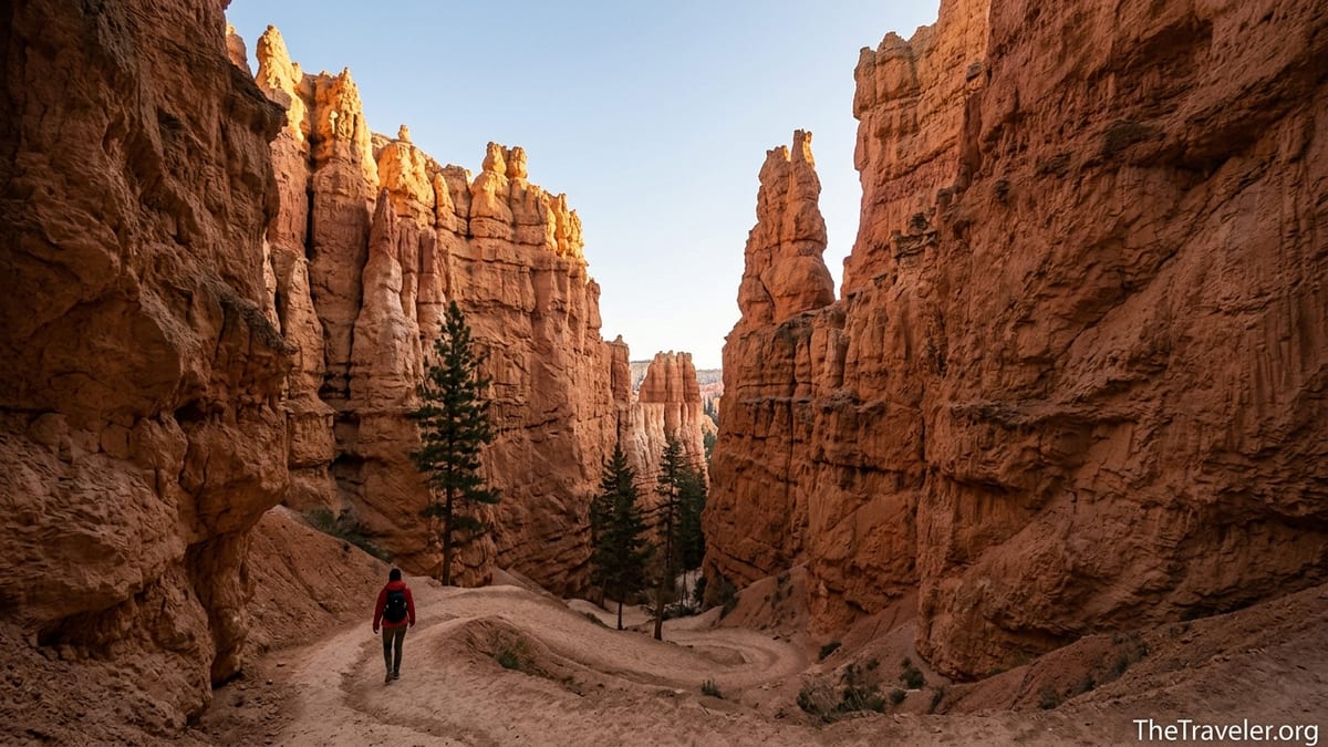
The temperature dropped noticeably as the canyon walls closed in. After the exposed upper switchbacks, walking into Wall Street felt like entering a stone cathedral. Sheer walls rose tens of meters above me, the sky reduced to a ribbon of blue between them. Light filtered down in thin sheets, painting the upper rock faces a rich golden orange while the lower reaches remained in deep shade. Ponderosa pines, improbably rooted in the narrow floor, stretched straight up in search of sun, their trunks so tall and slender that they seemed to bend with the canyon walls.
This half-mile section is where the crowds slow down, not because of difficulty, but because Wall Street invites lingering. Every few steps, people stopped to photograph the switchbacks from below, or to capture the contrast between a sliver of sky and the close-set rock. A couple from Germany stood beside me at one point, comparing the scene to a sandstone alleyway in a medieval city. Ahead of us, a family guided their kids carefully, one adult holding a small hand at each switchback to keep them from darting toward the drop-off at the outer edge.
Rangers often recommend tackling the Navajo Loop counterclockwise when conditions allow, descending through Wall Street rather than climbing up it. After walking through the narrowest section and looking back at the steep zigzag of steps, I understood why. Descending lets you appreciate the towering walls without the sustained cardio push of climbing. It also reduces the chances of bottlenecks at the tightest turns, where hikers sometimes pause to catch their breath and take photos. Even so, I kept in mind that in snowier months this very beauty can make the route hazardous, as ice clings to the shaded switchbacks long after the sunnier sections of trail have dried.
Life on the Canyon Floor
Once Wall Street spat me out onto the wider canyon bottom, the mood shifted yet again. The path leveled briefly, and I found myself in a sandy wash lined with more ponderosa pines, Douglas firs, and clusters of hardy shrubs. Birdsong, which had been distant and faint at the rim, became louder. I passed a small group gathered around a ranger who was pointing out lichen patterns on a boulder and explaining how freeze-thaw cycles have sculpted the hoodoos over millions of years.
It is one thing to read about frost wedging and eroding limestone in a brochure, and another to stand at the base of a hoodoo and see the process recorded in layers of crumbly, fluted stone. Up close, the hoodoos look less like solid pillars and more like vertical stacks of fragile ridges, each one softened at the edges. On a dry day, a light touch will send a sprinkle of dusty grains down the face. Rains and snowmelt do the same work more forcefully, carving deeper channels and occasionally bringing down entire chunks of rock.
Another surprise on the canyon floor was the sense of quiet, even with a steady stream of hikers. The rock walls muted wind and distant road noise, and people naturally lowered their voices in the enclosed space. At one point I stepped a few yards off to a signed pullout, away from the main tread of the trail, to photograph a trio of hoodoos catching the light. For a moment, the only sounds were the ticking of a distant beetle and the faint rustle of a chipmunk in the underbrush.
This is also where the reality of hiking at elevation began to catch up with some visitors coming from the opposite direction. A couple wearing daypacks and matching sun hats paused on a small bench, breathing heavily. They had started from the bottom, working their way up Navajo toward Sunset Point, and were feeling the combination of thin air and steady grade. We compared notes on where we had begun and traded encouragement, a reminder that on a short but intense trail like this, conversations with strangers can be as memorable as the scenery.
The Climb Back to the Rim
Every descent in Bryce comes with a price: the climb back out. The closing stretch of the Navajo Loop is a steady grind, with switchback after switchback stacked so closely together that the path sometimes feels like a set of outdoor stairs rather than a traditional trail. Even though I considered myself reasonably fit, I could feel my heart rate rise and my breathing deepen as I began the ascent.
The key was to treat this section more like a series of short intervals than a single, punishing hill. I would climb a segment of switchbacks, pause at a corner where the trail widened slightly, sip from my water bottle, and turn to take in the view opening behind me. The higher I climbed, the more of the amphitheater came back into view, with the hoodoos below arranging themselves into neat rows and clusters that had been impossible to distinguish from the canyon floor.
Hydration made a noticeable difference. On the morning I hiked, temperatures were still comfortably in the 60s Fahrenheit, but I watched more than one person reach for the last drops in a small half-liter bottle with a good fifteen to twenty minutes of climbing still ahead. Rangers recommend carrying at least a liter of water per person even for short below-the-rim hikes, more in summer. It is advice worth following. There are no water sources on the trail, and even in shoulder seasons the dry air can dehydrate you faster than you expect.
When I finally stepped back onto the broad overlook at Sunset Point, the transition felt abrupt. After nearly ninety minutes among rock walls and narrow corridors, the sudden sense of space, crowds, and paved paths was jarring. Yet there was also a quiet satisfaction in looking down at the line of tiny hikers now starting the same loop, knowing exactly how the trail would twist beneath them and what they had yet to see.
Planning Your Own Descent Into the Hoodoos
Reflecting on the hike afterward, I realized that descending into the hoodoos on the Navajo Loop had shaped my entire understanding of Bryce Canyon. It was not just about the novelty of walking through Wall Street’s slot-like corridor or standing at the base of Thor’s Hammer. The loop connected the park’s signature overlooks with a tangible, physical journey into the landscape that had previously felt like a distant spectacle.
If you plan to follow a similar path, the core logistics are straightforward but important. Start early in the day, ideally catching sunrise at either Sunrise or Inspiration Point, then aim to be at the Navajo Loop trailhead by eight or nine in the morning. Use the free park shuttle when it is running to avoid circling crowded parking lots, especially during peak season from late spring through early fall. Pay attention to posted trail conditions at the visitor center. Wall Street often closes in winter and early spring due to ice and rockfall, and in some recent seasons mudslides and storm damage have forced temporary closures of the entire Navajo Loop, sometimes with little notice.
Footwear and clothing choices matter. Lightweight hiking shoes or trail runners with good traction will make the switchbacks and loose gravel feel far more manageable. Even in summer, bring a light layer for the cooler temperatures at the pre-dawn rim and inside shaded sections of the canyon. In shoulder seasons, gloves and a beanie can make sunrise far more comfortable while you wait for the sun to reach your section of trail.
Finally, know that you have flexible options if Navajo is partially or fully closed when you visit. The Queen’s Garden Trail from Sunrise Point offers a gradual descent among equally striking hoodoos and can be hiked as an out-and-back. The Rim Trail between Sunrise and Sunset Points remains one of the most accessible ways to experience changing perspectives on the amphitheater. For stronger hikers, longer routes like the Peekaboo Loop from Bryce Point or the Figure 8 combination, when conditions allow, stitch together various below-the-rim segments for a deeper immersion into Bryce’s geology.
The Takeaway
Standing at the rim of Bryce Canyon is undeniably impressive, but it was only when I descended the Navajo Loop Trail that the park shifted from postcard-perfect scenery to a lived experience. The steep switchbacks beneath Sunset Point, the cool embrace of Wall Street’s narrow corridor, and the quiet moments on the canyon floor surrounded by towering hoodoos combined into a hike that felt far more substantial than its modest mileage suggests.
That mix of accessibility and intensity is what makes the Navajo Loop such a defining Bryce Canyon experience. It demands respect for altitude, weather, and trail conditions, yet it remains within reach for many visitors who are willing to pace themselves and prepare. Whether you pair it with Queen’s Garden for a classic combination loop, or simply hike down and back from Sunset Point when conditions allow, descending into the hoodoos will likely become the memory that lingers long after overlook views blend together.
If there is a single takeaway from my visit, it is this: give yourself the time and flexibility to leave the rim and step into the amphitheater. Check the latest conditions, start early, carry enough water, and be willing to adjust your plan. In return, Bryce Canyon will reward you with a perspective that no overlook alone can provide, a perspective earned one switchback at a time.
FAQ
Q1. How difficult is the Navajo Loop Trail for an average hiker?
The Navajo Loop is short but moderately strenuous, mainly because of its steep switchbacks and roughly 550 to 600 feet of elevation gain and loss at high altitude. Most reasonably fit hikers can complete it in 1 to 2 hours if they pace themselves and take breaks.
Q2. What is the best time of day to hike the Navajo Loop?
Mornings are generally best. Starting around or shortly after sunrise means cooler temperatures, softer light for photography, and fewer crowds on the switchbacks. In summer, midday heat can make the ascent back to the rim feel significantly harder.
Q3. Is the Navajo Loop Trail suitable for children?
Many families hike the Navajo Loop with school-aged children, but it requires close supervision. The trail has steep drop-offs at some switchbacks and loose gravel underfoot. Young kids who are used to walking a couple of miles can usually manage it, but strollers are not practical.
Q4. Do I need special gear to hike into the hoodoos?
You do not need mountaineering equipment, but sturdy footwear is important. Lightweight hiking shoes or trail runners with good tread, sun protection, and at least a liter of water per person are recommended. Trekking poles are helpful for those with knee issues or balance concerns.
Q5. What happens if Wall Street or the entire Navajo Loop is closed?
Seasonal closures of Wall Street are common due to ice, rockfall, or storm damage, and in some years mudslides have temporarily shut down the whole loop. If that happens, you can still hike the Queen’s Garden Trail, explore other below-the-rim routes like Peekaboo when open, and enjoy the Rim Trail viewpoints between Sunrise, Sunset, and Inspiration Points.
Q6. How busy does the Navajo Loop get during peak season?
From late spring through early fall, the Navajo Loop is one of the most popular hikes in Bryce Canyon and can feel crowded by late morning. Expect steady traffic at the switchbacks and particularly in the Wall Street section. Starting early or visiting in shoulder seasons like May or October helps avoid the heaviest crowds.
Q7. Can I combine the Navajo Loop with other trails in one hike?
Yes. A common and highly recommended option is the Queen’s Garden and Navajo Combination Loop, which links Sunrise and Sunset Points in a roughly 3-mile circuit. Stronger hikers may also connect Navajo with Peekaboo or longer routes when conditions and time allow.
Q8. Are pets allowed on the Navajo Loop Trail?
No. Pets are generally restricted to paved viewpoints, campgrounds, and certain sections of the Rim Trail at Bryce Canyon. They are not permitted on the Navajo Loop or other below-the-rim dirt trails, so plan boarding or pet care accordingly.
Q9. How does altitude affect hiking the Navajo Loop?
Bryce Canyon’s rim sits over 8,000 feet above sea level, which means thinner air and stronger sun. Visitors coming from lower elevations may notice that they tire more quickly, especially on the climb back to the rim. Taking it slow, drinking plenty of water, and avoiding excessive alcohol the night before can help.
Q10. Is the park shuttle necessary for hiking the Navajo Loop?
The shuttle is not mandatory, but it is very convenient. During the main season it provides frequent service between the visitor center, lodging, and key viewpoints like Sunrise and Sunset Points, reducing parking stress and traffic congestion near the trailheads.