


Stand at Sunset Point in Bryce Canyon National Park and you will see it immediately: a serpent of switchbacks plunging between orange cliffs, hikers shrinking to toy size as they disappear into a labyrinth of hoodoos. This is the Navajo Loop Trail, the short but spectacular path that has become the single most famous hike in Bryce Canyon and, for many travelers, the very definition of the park itself.
Get the latest updates straight to your inbox!
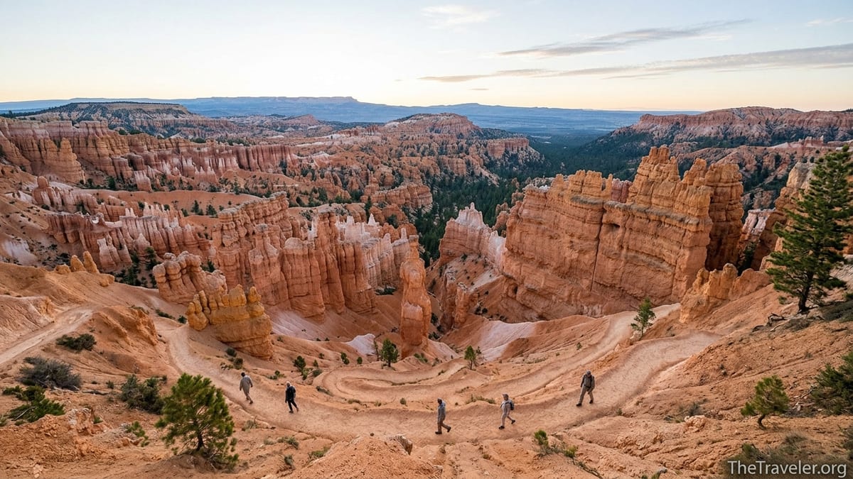
What Makes the Navajo Loop Trail So Famous
The Navajo Loop Trail has earned its reputation by packing an astonishing variety of Bryce Canyon’s trademark scenery into a compact distance. The loop is roughly 1.3 miles long, with about 500 to 550 feet of elevation change, starting and ending at Sunset Point along the main park road. In a single hour or two, most hikers experience towering hoodoos, tight slot-like corridors, sweeping amphitheater views, and the cool shade of a hidden forest on the canyon floor.
National Park Service materials and regional tourism boards consistently describe Navajo Loop, often combined with Queen’s Garden, as the park’s most popular hike and the one first-time visitors should prioritize. On a typical summer morning, you will see rental cars and RVs from across the United States lined up at Sunset Point, while international visitors arrive via tour buses from Las Vegas and Salt Lake City. For many of these travelers with only one day in the park, rangers and guidebooks point them to Navajo Loop as the essential Bryce experience.
The trail’s fame is also visual. Images of the Navajo switchbacks and the solitary hoodoo known as Thor’s Hammer appear in guidebooks, airline magazines, camera advertisements, and social media feeds. When friends ask travelers what Bryce Canyon is like, they often show a photo taken somewhere along this loop. That constant visual exposure has cemented Navajo Loop’s status as the hike everyone has at least seen, even if they have never been to Utah.
Location plays a role too. Because the trailhead sits just steps from the Sunset Point parking area and shuttle stop, visitors do not need a long approach hike or specialized gear to reach stunning viewpoints. Even those unsure about hiking at higher elevations can walk a short distance along the rim, look down at the switchbacks, and decide on the spot whether to commit to the descent.
Signature Landmarks: Wall Street, Two Bridges, and Thor’s Hammer
Although short, the Navajo Loop Trail feels like a greatest-hits album of Bryce Canyon landmarks. The most talked-about feature is Wall Street, a narrow side of the loop where steep, tightly stacked switchbacks slice through towering orange walls. At the base of this slot-like corridor, a small grove of Douglas firs stretches improbably toward a sliver of sky hundreds of feet above. When conditions allow it to open, hikers pause here to run their hands along the cool rock and photograph the fir trunks framed by vertical canyon walls.
The other half of the loop, known as the Two Bridges side, offers a different mood. Here the canyon feels more open, with long sightlines across fins and hoodoos. As the name suggests, this segment passes two natural rock bridges carved into an adjacent ravine. Hikers often stop on the switchbacks to look back and spot the twin spans, which appear and disappear depending on the angle. For many, this side of the loop becomes their unexpected favorite, especially when Wall Street is closed by seasonal rockfall concerns.
Then there is Thor’s Hammer, arguably the single most photographed hoodoo in Bryce Canyon. This tall, slender pillar topped by a larger block of rock stands just off the trail near the upper part of the loop on the Two Bridges side. Sunrise and late-afternoon light paint Thor’s Hammer in deep oranges and reds, and it is common to see a line of photographers with tripods waiting for the sun to strike the formation. Even casual hikers with smartphones often recognize it from postcards or park posters before they realize they are standing in front of the real thing.
These specific formations give the trail a sense of narrative. A couple visiting from Chicago, for example, might start at Sunset Point with broad amphitheater views, descend through tight Wall Street switchbacks, emerge among hoodoos on the canyon floor, and then climb past Thor’s Hammer back to the rim. Instead of feeling like a generic hike in a beautiful place, the experience becomes a sequence of named landmarks they will remember and talk about long after the trip.
A Short Trail With Big Hike Energy
One reason Navajo Loop is so beloved is that it feels like a big, dramatic hike while remaining accessible to many visitors. The loop is only a little over a mile, but the quick 500-plus feet of descent and re-ascent give hikers a sense of accomplishment similar to longer canyon trails in other parks. Travelers who might never attempt a strenuous all-day route at Grand Canyon or Zion can still say, truthfully, that they have hiked down into Bryce’s amphitheater and climbed back out.
That compact challenge makes the trail perfect for busy itineraries. Many visitors combine Bryce Canyon with Zion National Park or a loop from Las Vegas that includes Page, Arizona. A typical day might see someone leave Springdale near Zion before dawn, arrive at Bryce Canyon by mid-morning, hike the Queen’s Garden and Navajo Loop combination in two to three hours, then continue toward Capitol Reef or back to Zion by evening. Because the hike is short and near the main viewpoints, travelers can still catch a sunset at Bryce Point or Inspiration Point without feeling rushed.
The trail also lends itself well to different pacing. A family with young children might treat the loop as their main activity for the entire day, stopping frequently for snacks and photos, sitting in the shade among the hoodoos on the canyon floor, and finishing in three unhurried hours. A fit solo traveler starting at sunrise might complete the loop in under an hour, then extend the day by linking Navajo with the Peekaboo Loop or continuing along the Rim Trail.
Equally important, hikers can “sample” the Navajo experience without committing to the full loop. Some visitors descend only partway from Sunset Point, walk a short distance among the formations, and then climb back up the way they came. Others pair just the Two Bridges side with connecting trails if Wall Street is temporarily closed. This flexibility keeps the trail popular even when conditions or personal fitness limit options.
The Navajo Loop as the Heart of Classic Combinations
While Navajo Loop is impressive on its own, it becomes truly iconic when combined with neighboring trails. Park rangers often recommend the Queen’s Garden and Navajo Loop combination, a roughly 2.9-mile circuit that descends from Sunrise Point, winds among whimsical hoodoos in Queen’s Garden, crosses the canyon floor, and climbs back to the rim via Navajo’s switchbacks. Visitor guides describe this as the definitive Bryce Canyon hike for first-timers: long enough to feel immersive, but still manageable in 2 to 3 hours for most moderately fit travelers.
On the ground, this combination feels like walking through a series of outdoor galleries. From Sunrise Point, the Queen’s Garden trail drops gently past formations that resemble castles and turrets. Hikers often pause at a viewpoint where a hoodoo loosely resembles a seated queen, hence the trail’s name. As the path approaches the sandy bottom of the amphitheater, the perspective shifts from distant vistas to close-up textures in the rock, and chipmunks occasionally dart across the trail looking for crumbs from distracted visitors.
After crossing the canyon floor on a signed connector path, hikers reach the base of the Navajo Loop, where they choose between the Two Bridges and Wall Street sides, depending on which is open. Climbing back to Sunset Point, they re-emerge at the rim with a new appreciation for the amphitheater they viewed distantly earlier that morning. From there, a short, mostly flat stroll along the paved Rim Trail returns them to their starting point at Sunrise Point, with near-continuous views into the canyon.
For those craving a longer day, the Figure 8 combination connects Queens Garden, Navajo Loop, and Peekaboo Loop into a roughly 6.4-mile circuit with around 1,500 feet of elevation gain. Adventure-oriented travelers base themselves in nearby Bryce Canyon City or Tropic, start at Sunrise or Sunset Point, and spend four to five hours threading through the heart of the Bryce Amphitheater. In that Figure 8, Navajo Loop still provides the most dramatic entry or exit to the system, reinforcing its central role in how visitors experience the park.
Planning Your Hike: Conditions, Safety, and Timing
Because Navajo Loop is so popular, thoughtful planning can significantly improve the experience. First, check current conditions before you go. The trail’s Wall Street section is often closed in winter and early spring due to ice and rockfall risk, and in recent seasons, heavy rains have occasionally caused temporary mudslides that close parts of the loop. Bryce Canyon National Park and regional tourism organizations post updates regularly, and rangers at the visitor center can explain which segments are open on a given day.
Season affects both safety and comfort. Bryce Canyon sits at over 8,000 feet above sea level, so even in June and July the mornings can be chilly, while midday sun at the canyon floor may feel surprisingly intense. In winter, snow and ice linger on the switchbacks, and many hikers use traction devices they purchase at outfitters in nearby towns like Panguitch or pick up at general stores in Bryce Canyon City. In summer, dehydration becomes the primary risk, and it is common to see visitors who underestimated the elevation pausing frequently on the climb out.
Timing matters. To avoid crowds and harsh light, many experienced travelers start the Navajo or Queen’s Garden combination shortly after sunrise. A visitor staying at the park lodge, for example, can walk to Sunrise or Sunset Point before breakfast, descend while the switchbacks are still mostly in shade, and be back at the rim before tour buses arrive from Las Vegas. Others time their hike for late afternoon, finishing the ascent as the low sun catches the hoodoo tops and most day-trippers are leaving the park.
Parking and park entry also warrant attention. As of mid-2026, a private vehicle entrance pass for Bryce Canyon is roughly in the mid-30-dollar range and is valid for several days, while pedestrians and cyclists pay a lower per-person fee. Non-U.S. residents over 16 are also subject to an additional national park nonresident fee, unless covered by specific passes. Many travelers driving a loop through Utah’s parks find that an America the Beautiful annual pass quickly pays for itself, especially if they also plan to visit nearby Zion or Capitol Reef during the same trip.
Experiencing Bryce Canyon’s Geology Up Close
Navajo Loop is famous not just for its views but also for how intimately it introduces visitors to Bryce Canyon’s geology. From the rim, the amphitheater resembles a vast, colorful bowl of rock spires. Once you step onto the trail, however, those spires become tangible objects, and the patterns that shaped them are easier to see. The path winds between eroded fins of the Claron Formation, where freeze-thaw cycles and summer monsoon rains have sculpted arches, windows, and delicate towers over millions of years.
On the canyon floor, the scale of the hoodoos changes dramatically. A formation that looked pencil-thin from above might tower many meters overhead when viewed from its base. Hikers often notice distinct horizontal bands of lighter and darker rock, evidence of ancient lake sediments laid down over time. The close-up textures of the sandstone, from coarse grains that crumble under a boot heel to smoother surfaces polished by runoff, give a tactile sense of the landscape’s constant transformation.
The trail also passes living markers of this environment. In narrow sections like Wall Street, tall Douglas firs have grown toward the limited light, some reaching surprising heights despite extreme temperature swings and thin, rocky soils. Their deep green needles contrast strongly with the orange canyon walls, and in the heat of the day the shaded air around them can feel several degrees cooler. Jays, ravens, and occasional mule deer add to the impression that the amphitheater is not merely a backdrop but a functioning ecosystem.
For many visitors, this proximity to both rock and life is what turns Bryce Canyon from a scenic overlook into a place they feel they have truly explored. A couple from Germany, for instance, might arrive expecting to simply check another national park off their list. After following Navajo’s switchbacks, touching the cool canyon walls, and hearing the muffled echo of their footsteps below the rim, they often leave with a more personal connection and a better understanding of how fragile and dynamic the hoodoo landscape really is.
Practical Tips for First-Time Hikers
Although Navajo Loop is considered moderate, preparation still makes a big difference in comfort and safety. Sturdy footwear with good tread is important, especially on the steep, dusty switchbacks where loose grit can act like ball bearings underfoot. Many hikers wear basic trail shoes or lightweight hiking boots they bought from outdoor retailers before their trip, while others make do with athletic shoes. Flip-flops and smooth-soled sandals are a common sight at the trailhead but often cause problems on the descent.
Water and sun protection are equally essential. The trail begins at high elevation, and even mild exertion can feel more strenuous than at sea level. A reasonable guideline is to carry at least one liter of water per person for the Navajo and Queen’s Garden combination, more in hot weather. Wide-brimmed hats, sunglasses, and sunscreen help on exposed sections near the rim, while breathable layers allow hikers to adjust as temperatures change between shady canyon floor and open viewpoints.
Families and less-experienced hikers should be aware that the most difficult part of the loop is the climb out, not the descent. It is deceptively easy to walk down into the canyon, taking photos and feeling energized, only to realize on the way up that the switchbacks are steeper than expected. A smart strategy is to turn around if anyone in the group feels uncertain early on, while the return still involves relatively gentle elevation gain. Parents with small children often use child carriers rather than strollers, since the trail is too steep and uneven for wheels.
Finally, consider using the park’s seasonal shuttle system to reduce parking stress at Sunset and Sunrise Points. Many travelers leave their car at the visitor center or Bryce Canyon City shuttle stop and ride to the rim, where they can begin the hike without circling lots for a space. After finishing the loop and perhaps walking part of the Rim Trail, they simply catch another shuttle back, freeing them to enjoy the views instead of worrying about driving between trailheads.
The Takeaway
The Navajo Loop Trail has become Bryce Canyon’s most famous hike because it delivers everything travelers hope to find in this park in a compact, accessible package. In just a mile or two, visitors descend from world-class viewpoints into a maze of hoodoos, walk through narrow corridors like Wall Street, stand beneath icons such as Thor’s Hammer, and then climb back to the rim with a new perspective on the amphitheater they first saw from above.
Its strategic location at Sunset Point, its role in classic combinations like the Queen’s Garden and Navajo Loop circuit, and its ability to fit into a half-day itinerary all contribute to its popularity. Yet beyond logistics and Instagram images, what keeps people talking about this trail is the visceral experience of stepping off the rim and into the canyon’s depths. Whether you are driving a long loop through the American Southwest or making a focused trip to Utah’s national parks, building your Bryce Canyon visit around Navajo Loop is one of the most rewarding decisions you can make.
FAQ
Q1. How long does it take to hike the Navajo Loop Trail?
Most visitors complete the Navajo Loop in about 1 to 1.5 hours, or 2 to 3 hours when combined with Queen’s Garden. Times vary depending on fitness, photo stops, and trail conditions.
Q2. Is the Navajo Loop Trail suitable for beginners?
The trail is considered moderate. Beginners who are reasonably fit and take their time usually manage it well, but the steep climb out can feel challenging, especially at high elevation.
Q3. Which direction should I hike, clockwise or counterclockwise?
Many hikers descend via Queen’s Garden from Sunrise Point and climb up Navajo to Sunset Point. If hiking Navajo alone, direction matters less, but some prefer to descend the steeper side and climb the slightly more gradual one.
Q4. Is Wall Street always open?
No. The Wall Street section frequently closes in winter and early spring due to ice and rockfall concerns, and heavy rains can also cause temporary closures. Always check current conditions with rangers before starting.
Q5. Do I need special gear for the Navajo Loop?
You do not need technical equipment, but sturdy shoes with good traction, water, sun protection, and layers for changing temperatures are strongly recommended. In winter, traction devices can be very helpful on icy sections.
Q6. Can children hike the Navajo Loop?
Many families hike the trail with children. Parents should be prepared for the steep ascent, keep kids away from the rim edges, and consider child carriers for toddlers, as the path is not suitable for strollers.
Q7. What is the best time of day to hike Navajo Loop?
Early morning and late afternoon are ideal. Temperatures are cooler, lighting on the hoodoos is more dramatic, and crowds are generally smaller than at midday, especially in peak season.
Q8. How does Navajo Loop compare to other Bryce Canyon trails?
Navajo Loop is shorter than long routes like Fairyland or Peekaboo but showcases Bryce’s classic scenery more intensely. For first-time visitors with limited time, it is usually the top recommendation.
Q9. Can I hike Navajo Loop in winter?
Yes, but conditions can be snowy and icy, and Wall Street is often closed. Winter hikers should wear traction devices, dress warmly in layers, and check trail status before heading out.
Q10. Is parking available at the trailhead?
Parking is available at Sunset Point, but spaces fill quickly in busy seasons. Using the park’s shuttle system is often easier, allowing you to start the hike without worrying about finding a spot.