
Newfound Gap Road is the classic drive in Great Smoky Mountains National Park, climbing 31 miles between Cherokee, North Carolina and Gatlinburg, Tennessee. The road twists from leafy river valleys to spruce fir ridgelines over 5,000 feet, with a string of overlooks that invite you to pull over every few minutes. With limited parking and fast-changing mountain light, it helps to know in advance which stops deliver the best views and photo opportunities. This guide walks you south to north along Newfound Gap Road, highlighting the most rewarding overlooks, short walks, and photo angles so you can make the most of a half-day drive or sunrise-to-sunset photography run.
Get the latest updates straight to your inbox!
Planning Your Drive on Newfound Gap Road
Newfound Gap Road, also signed as US 441, is the main north south corridor through Great Smoky Mountains National Park, linking Cherokee and Gatlinburg over a distance of about 31 miles. Elevation jumps from roughly 2,000 feet near the park entrances to just over 5,000 feet at Newfound Gap itself, which makes the scenery feel as if you have driven from lowland hardwood forest into a high elevation Canadian style spruce fir ecosystem in under an hour. Because of that elevation gain, temperatures at the top can easily run 10 to 15 degrees cooler than in Gatlinburg or Cherokee, and wet weather in the valleys can translate to fog or even snow higher up, especially from late fall through early spring.
Most visitors will want at least two to four hours to enjoy the overlooks without feeling rushed, more if you plan to hike short trails like the Appalachian Trail at Newfound Gap or the start of Alum Cave Trail on the Tennessee side. In high season, typically June through October and on holiday weekends, traffic along Newfound Gap Road can be slow and parking at the most popular pullouts may be briefly full. The park now requires a parking tag if you stop longer than 15 minutes, which you can purchase at visitor centers like Oconaluftee or Sugarlands or from machines at some lots. Having that tag visible on your dashboard gives you freedom to linger at a viewpoint instead of watching the clock.
Photographers should factor sun angle and direction into their timing. Sunrise light tends to favor the North Carolina side and high elevation overlooks, while sunset often works best at west facing pullouts such as Morton Overlook and the upper switchbacks near Gatlinburg. In mid summer, haze can soften mid day views, so many landscape shooters target early morning or the hours after a cold front clears the air. Even if you are just using a smartphone, those clearer windows can make the difference between a washed out horizon and a ridge after ridge panorama with crisp detail.
The descriptions below move from south to north, starting at the Cherokee entrance. If you are based in Gatlinburg, simply reverse the order and keep in mind that sunrise and sunset recommendations will swap sides as you drive toward or away from the light.
Oconaluftee Valley and the Lower Pullouts from Cherokee
Leaving Cherokee and entering the park from the south, Newfound Gap Road initially follows the Oconaluftee River through a broad valley. While this stretch lacks big mountain vistas, it offers intimate scenes that can be surprisingly photogenic, especially in early morning fog or during peak fall color. Several paved pullouts appear along the river; they are unmarked, but you will recognize them by stone guardwalls and room for a handful of cars. These are good places to stop for long exposure shots of the river tumbling over boulders or for simple family photos beside the clear water.
Just beyond the Oconaluftee Visitor Center, many visitors are drawn to the nearby Mountain Farm Museum, where historic log buildings sit against a wooded backdrop. While not a formal overlook, the museum area offers easy foreground interest for photos, including split rail fences and barns, with low ridges rising beyond. In spring, wildflowers and budding trees soften the scene, while in autumn, the surrounding hillsides turn shades of gold and red that photograph well even under cloudy skies.
As you start to climb toward the crest, watch for signed pullouts that begin to open up views back down the valley. These lower overlooks tend to be less crowded than the ones near the gap, which makes them ideal if you like uncluttered compositions or want to set up a tripod without worrying about people walking into the frame. Late afternoon light often grazes the hillsides here, adding texture to otherwise gentle slopes.
One practical advantage of stopping early in the climb is that it helps you gauge road and weather conditions higher up. If you are already seeing low clouds wrapping the ridges above, you may want to adjust expectations for distant views and instead focus on close range subjects like wet foliage, reflections in roadside puddles, and moody forest shots under the tree canopy.
Climbing to the Crest: Pre Gap Overlooks and Forest Views
Roughly midway between Cherokee and Newfound Gap, the road begins to curve more tightly and the forest shifts toward mixed hardwood and conifer slopes. A series of small to medium pullouts offer views into side valleys and across the layered ridges that give the Smokies their name. These overlooks are often unnamed on maps, but they are worth quick stops, especially if cloud layers are moving through. On days with broken clouds, beams of sunlight can spotlight individual ridges in the distance, creating high contrast scenes that change minute by minute.
These middle elevation stops also work well in less than perfect weather. When fog fills the highest gaps, you may still enjoy partial views here, capturing mist drifting between tree covered hillsides. Even a basic phone camera can handle these scenes, but a polarizing filter on a dedicated camera or clip on phone lens helps cut through glare and bring out the greens of the forest after rain. If you have time, walk to the far ends of each pullout; often the best angle is not directly in front of the parking area but thirty or forty feet away where overhanging branches frame the view.
Practical considerations matter here too. These pullouts tend to be smaller, typically accommodating only a few cars. If you are traveling in a larger vehicle like a campervan, aim for the slightly bigger overlooks signed with brown scenic view markers. Always pull fully off the pavement with all four wheels out of the travel lane, since enforcement has increased in recent years for vehicles stopped on shoulders or in unmarked spots.
Because these views face in a variety of directions depending on the curve of the road, there is usually something workable regardless of time of day. Mid morning and mid afternoon can both be productive, especially if you are shooting details like individual trees on distant ridges, roadside wildflowers, or rain streaks across the valley rather than trying to capture the whole horizon.
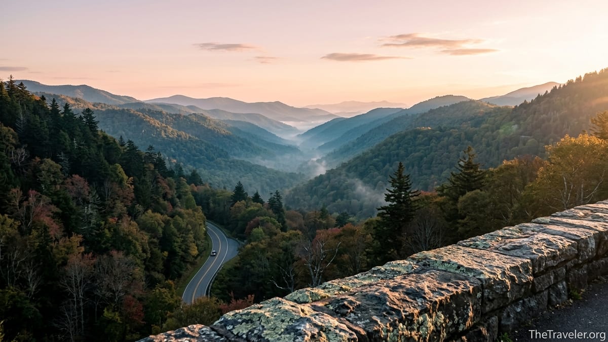
Newfound Gap Overlook: The Classic Smokies Panorama
At just over 5,000 feet, Newfound Gap Overlook is the undisputed centerpiece of the drive and one of the easiest big views in the park. A wide parking lot straddles the Tennessee and North Carolina state line, with seasonal restrooms and interpretive signs. From the stone terrace near the Rockefeller Memorial, where President Franklin D. Roosevelt dedicated the park in 1940, you can look out over a cascade of ridges that often fade from deep green in the foreground to soft blue on the far horizon. On clear days after a cold front, visibility can seem almost endless, while in summer, humidity creates a dreamy, layered effect that lives up to the park’s name.
For photos, plan to explore both sides of the parking area. On the south facing side, you get broad views into North Carolina, especially suited to wide angle lenses or phone panoramas. On the north side, shorter stone walls frame evergreen trees and offer glimpses toward the Tennessee side. Many photographers like to place the stone architecture or the state line sign in the foreground to anchor the sweeping landscape behind. If you are traveling with kids or older relatives, this is also a good spot for group photos, thanks to relatively level pavement and lots of room to move around.
Newfound Gap is one of the busiest stops on the road, and parking can be tight from late morning through mid afternoon in peak season. If possible, aim for early morning or late day. At sunrise, the sun often breaks over the ridges to the east, illuminating clouds from below and backlighting the layers of hills. At sunset, the opposite side of the sky can glow subtly, lending soft pastel tones to the western view. Photographers who want a quieter experience can also walk a short distance along the Appalachian Trail, which crosses the parking lot; after a few minutes of hiking, you will usually find viewpoints with fewer people and slightly different angles on the same landscape.
Because of the elevation, conditions at Newfound Gap can shift quickly. In winter and on the shoulders of the season, roads may be icy or closed temporarily, and even in summer a storm can roll in fast. It is smart to keep a light jacket or windbreaker in the car, even if it felt warm when you left Gatlinburg or Cherokee. The cooler air and frequent breezes, however, are a major advantage in midsummer when lower valley viewpoints can feel hazy and hot.
Side Trip to Kuwohi Road and Clingmans Dome Area
Just west of Newfound Gap, a signed junction leads onto Kuwohi Road, the spur that climbs toward Kuwohi, also known as Clingmans Dome, the highest point in the park. The road typically operates seasonally, often from spring into late fall, though opening and closing dates vary with maintenance and weather. When the road is open, the seven mile drive adds a series of additional pullouts with impressive views, and at the top a small visitor center and paved path lead to the concrete observation tower. While the tower itself sits slightly off Newfound Gap Road, it is closely tied to the same high elevation ridge and is a major photography destination.
Along Kuwohi Road, several roadside pullouts offer views across dark spruce fir slopes and into deep, branching valleys. The forest here feels markedly different from the lower hardwood zones, with mossy trunks and cooler air. Photographers often use these stops to capture moody scenes of clouds wrapping the ridgeline or to shoot telephoto compositions of distant peaks aligned behind one another. In late fall, when leaves have dropped at lower levels, you may still see patches of color in sheltered coves, contrasted against nearly black evergreen crowns above.
At the upper parking area, a steep but paved half mile path climbs to the observation tower. On busy days, this lot can fill by late morning, and the path may resemble a slow moving line of visitors. For more peaceful photography, aim for early or late in the day or shoulder season periods when the road is open but crowds are lighter. From the tower, you get true 360 degree views, which helps when you are trying to work around the direction of light; you can simply walk to the side that best suits the current sky. Favor slightly hazy days for classic Smokies layers or crystal clear days after a front if you want maximum sharpness and long range visibility.
If Kuwohi Road is closed, usually in winter, it is still possible for prepared visitors to walk, cycle, or ski portions of the road under appropriate conditions, turning the quiet pavement itself into a unique photo subject. Bare trees framing snowy asphalt, or hikers silhouetted against a muted sky, can make for striking images even without the distant mountain layers that draw most visitors in peak season.
Morton Overlook and the Tennessee Side Switchbacks
Back on Newfound Gap Road heading toward Gatlinburg, the most famous stop for sunset is Morton Overlook. Perched on a curve just below the gap, this medium sized pullout looks west into a deep, V shaped valley that perfectly frames the descending sun for much of the year. On summer evenings, photographers line the stone wall with tripods to capture the sun dropping behind jagged ridges, golden light spilling down the valley, and car headlights tracing a ribbon of brightness along the distant road. Even with a basic phone camera, it is hard to take a truly bad picture here when conditions line up.
Because Morton Overlook is so popular, especially on clear summer and fall evenings, plan to arrive at least 45 to 60 minutes before sunset if you want a parking spot and room along the wall. If the main spaces are full, consider continuing down a short distance to less crowded pullouts and walking back up on the shoulder where it is safe to do so. For composition, try both wide angle views that capture the whole valley and tighter crops that focus on a single illuminated ridge or the winding road below. If scattered clouds are present, sunset can produce dramatic rays and color; on completely clear evenings, the scene is simpler but still rewarding.
As you descend the Tennessee side beyond Morton Overlook, the road wraps through a series of switchbacks and short tunnels carved into the mountainside. Several pullouts along this stretch are unsigned but provide excellent views into deeply cut hollows and across to opposing ridges. These stops tend to see more drive by traffic and fewer people lingering than Newfound Gap or Morton, making them ideal if you like to work quietly. One common composition places the stone guardwall in the foreground, leading the eye toward receding hills, which works especially well under low, side lit conditions in late afternoon.
Near the lower section, some pullouts offer a partial view back up toward the higher road, where you can occasionally catch tiny silhouettes of cars or even the outline of the Clingmans Dome tower on the skyline with a telephoto lens. This is a reminder of how much elevation you cover during the drive and can make for a compelling before and after pair if you photograph both the upper and lower stretches in similar light.
For safety, remember that the descent toward Gatlinburg is fairly steep, and traffic can back up behind slow vehicles or suddenly stop when a bear appears near the road. Always use your turn signal well in advance of entering or leaving a pullout, and avoid the temptation to stop in the road for wildlife photos. Rangers are strict about this, and it also creates real hazards on a curving, mountain highway.
Trailheads with Bonus Views: Alum Cave and Appalachian Trail
Some of the most satisfying views connected to Newfound Gap Road are found not directly at roadside overlooks but at trailheads that begin along the corridor. On the Tennessee side, the Alum Cave Trailhead, roughly a dozen miles from Gatlinburg, is one of the most popular hiking starting points in the park. While the namesake Alum Cave Bluffs lie a couple of miles up the trail, even the lower section offers photogenic scenes of rushing streams, wooden bridges, and narrow passages between rock outcrops. Hikers who continue to the bluffs are rewarded with sweeping views from a high, rocky perch, where the valley drops away and distant ridges step into the horizon.
Alum Cave Trail is not a roadside overlook, and the roughly 4.6 mile round trip to the bluffs is considered moderate to strenuous, but for travelers with half a day to spare, it adds a more immersive vantage point to the drive. Many people combine a morning hike to Alum Cave with an afternoon or evening cruise up to Newfound Gap and Morton Overlook, giving them both an on the ground and drive up experience of the same mountain landscape. Because the trailhead parking area can fill early, especially in summer and fall, an early start serves both hikers and photographers, with softer light and cooler temperatures along the shaded trail.
At Newfound Gap itself, the Appalachian Trail offers quick access to quieter viewpoints within just a few minutes of walking. Heading in either direction, the path traverses spruce fir forest, occasionally emerging at rock outcrops or small clearings with windows onto the surrounding ridges. These mini vistas are excellent places for more contemplative shots, where you can frame a single gnarled tree against blue layers or capture mist rising between hills after a passing shower. Because most casual visitors stay close to the parking lot, you may have stretches of trail nearly to yourself, especially in early morning.
Another option for strong hikers is to follow the Appalachian Trail north from Newfound Gap toward well known viewpoints on exposed ridges. This route requires several hours and good fitness but repays the effort with wide open views and a sense of traveling the Smokies backbone rather than just skimming its surface by car. If you take this approach, be sure to carry adequate water, layers, and a trail map, and remember that a parking tag is still required for your vehicle back at the gap for longer visits.
The Takeaway
Driving Newfound Gap Road is more than a way to get from Cherokee to Gatlinburg. It is a rolling overlook that compresses an incredible range of ecosystems, climates, and vantage points into a single, unforgettable drive. From quiet pullouts along the Oconaluftee River to the wide stone terraces of Newfound Gap and the golden hour magic of Morton Overlook, each stop offers a slightly different take on the same mountain story. With a bit of planning around weather, time of day, and parking, you can turn a simple transit into a highlight of your Smokies trip.
Whether you are an avid photographer carrying multiple lenses or a road tripper snapping shots on a phone, the key is to slow down. Step away from the car, walk to the far end of each overlook, and give the shifting mountain light a chance to work. If conditions are hazy at one stop, they may clear a few miles up the road; if Kuwohi Road is temporarily closed, another pullout may surprise you with a shaft of sun and a view you never expected. Newfound Gap Road rewards curiosity and patience, and when you leave space in your schedule to explore its best stops, your memory card will fill with the kind of layered, misty vistas that define the Great Smoky Mountains.
FAQ
Q1. How much time should I plan to drive Newfound Gap Road if I want to stop for photos?
Most travelers should plan at least three to four hours for the full 31 mile drive between Cherokee and Gatlinburg if you want to stop at major overlooks like Newfound Gap and Morton Overlook, explore a few smaller pullouts, and have time for short walks without feeling rushed.
Q2. Which direction is better for views, driving from Cherokee to Gatlinburg or the reverse?
The scenery is impressive in both directions, but many visitors prefer starting in Cherokee and driving north so that the most dramatic high elevation views at Newfound Gap and Morton Overlook arrive later in the drive, when the light is often better and you have settled into the rhythm of stopping at pullouts.
Q3. What is the single best overlook on Newfound Gap Road for first time visitors?
If you only have time for one stop, make it Newfound Gap Overlook. The large parking area, stone terraces, and sweeping views into North Carolina and Tennessee make it an essential stop, and you can add a short walk on the Appalachian Trail if you want a quieter vantage point.
Q4. Where is the best place on Newfound Gap Road to watch sunset?
Morton Overlook on the Tennessee side is widely regarded as the premier sunset spot, thanks to its west facing view into a deep valley where the sun often sets directly over layered ridges, creating classic golden hour scenes.
Q5. Is there a fee or permit required to stop at overlooks along Newfound Gap Road?
There is no entrance fee to drive through Great Smoky Mountains National Park, but the park requires a parking tag if your vehicle is stopped for more than 15 minutes at overlooks, trailheads, or pullouts, so it is wise to purchase a tag before starting the drive.
Q6. When is Kuwohi Road to Clingmans Dome typically open for the side trip from Newfound Gap?
Kuwohi Road usually operates seasonally, often from spring into late fall, though exact opening and closing dates vary with weather and maintenance conditions, so it is important to check current park updates before planning your detour.
Q7. Are the overlooks and Newfound Gap Overlook accessible for people with limited mobility?
Many overlooks, including Newfound Gap, have paved parking and relatively level areas near the stone walls, making them accessible for many visitors with limited mobility, though some uneven surfaces and steps exist, so using mobility aids and taking care around curbs is still necessary.
Q8. Can I rely on cell service along Newfound Gap Road for navigation and weather updates?
Cell coverage is inconsistent along Newfound Gap Road, with some sections offering a usable signal and others dropping entirely, so it is smart to download offline maps in advance and check weather forecasts before entering the park rather than relying on continuous data.
Q9. What is the best season for photography along Newfound Gap Road?
Every season has its advantages, but many photographers favor autumn for colorful foliage and crisp air, late spring for fresh greens and wildflowers, and clear winter days when the air is especially transparent and snow may dust the higher ridges.
Q10. Are tripods and professional cameras allowed at Newfound Gap Road overlooks?
Tripods and professional camera gear are generally allowed at overlooks and along trails as long as you set up without blocking traffic or walkways, respect safety barriers, and avoid creating congestion at popular spots such as Morton Overlook during peak sunset times.