
More news on this day
Burleson County in southeast Texas has issued an urgent alert urging residents and travelers to avoid nonessential trips as rounds of severe storms and potentially flooding rains continue to sweep across the region this week.
Get the latest news straight to your inbox!
Flood watch and days of heavy rain trigger local alert
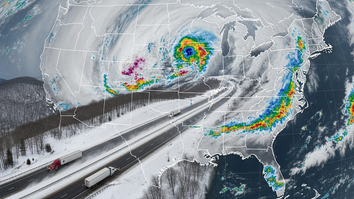
The travel alert follows a broader flood watch issued by the National Weather Service for portions of south central and southeast Texas, including Burleson County, as repeated waves of showers and thunderstorms move through the state. Forecasts indicate that rainfall totals through midweek could reach 2 to 4 inches in many areas, with localized pockets approaching 6 to 8 inches where storms repeatedly track over the same communities.
Publicly available information shows that the storm pattern is part of a prolonged, multi day severe weather setup affecting much of Texas. Along with intense rainfall, the system has already produced flash flooding, strong straight line winds and pockets of large hail in several counties. Local emergency managers in Burleson County have responded by urging drivers to stay off flooded or low lying roads and to defer discretionary travel until conditions stabilize.
Reports indicate that the alert is designed to reduce the number of vehicles on roads that could quickly become impassable during heavy downpours. Low water crossings, rural routes and farm to market roads are considered particularly vulnerable, especially at night when flooded stretches are more difficult to see.
Regional storms disrupt transportation and outdoor plans
The Burleson County advisory comes as severe storms disrupt travel across wider areas of Texas. Media outlets in North and Central Texas report that strong thunderstorms over the weekend led to significant flooding in spots, with vehicles stranded on inundated highways and police advising residents in some communities to remain at home due to rapidly deteriorating road conditions.
In the Waco and Hewitt areas to the north, heavy rainfall on Sunday led to widespread street flooding, including along Interstate 35, where standing water slowed or blocked traffic. Local coverage from Central Texas described rainfall totals of three to five inches in a matter of hours, demonstrating how quickly travel corridors can be affected when storms repeatedly track over the same zone.
Farther south and east, forecasts point to continued storm chances for the Houston region and adjoining counties, including Burleson County’s broader area of influence. This places through travelers, commercial drivers and holiday motorists at heightened risk of encountering flooded stretches, lane closures and delays as they move through the state.
Statewide emergency posture raised as flood threat evolves
At the state level, Texas has increased its emergency posture in response to the evolving severe weather and flood risks. According to recent press releases and regional coverage, the Texas Division of Emergency Management has been directed to operate the State Emergency Operations Center around the clock and to stage additional response assets in threatened areas.
This heightened readiness includes high profile vehicles capable of operating in standing water, specialized search and rescue teams and support for local jurisdictions coping with power outages, blocked roads and localized evacuations. Public information emphasizes that these resources are intended to back up county level operations where storms and flooding threaten public safety or force road closures.
While Burleson County is one of many jurisdictions under a flood watch, the county’s decision to highlight travel risks underscores concerns that even short trips can become hazardous during intense cloudbursts. Authorities across affected regions are urging people to closely monitor local forecasts and be prepared for rapidly changing road conditions.
What travelers in and around Burleson County should expect
For people currently on the road or planning to drive through Burleson County and nearby parts of southeast Texas, conditions may vary significantly over short distances. Some stretches may remain merely wet while others, especially low lying or poorly drained areas, could experience sudden rises in water level as storms pass overhead.
Travel industry observers note that disruptions to regional traffic flows can cascade outward, delaying intercity buses, freight shipments and long distance drives, particularly along popular north south and east west corridors. Even where highways remain open, heavier traffic volumes may build as drivers divert from flooded side roads onto main routes.
Public advisories consistently stress that drivers should never attempt to cross water covered roadways, even when the flooded section appears shallow. Past incidents across Texas show that vehicles can be swept off washed out roads in a matter of seconds, and many flood related fatalities occur when motorists underestimate water depth or current strength.
Preparedness advice for residents and visitors
For residents of Burleson County, the current alert serves as a reminder to review personal emergency plans, check that vehicles have sufficient fuel and ensure that essential supplies such as drinking water, medications and nonperishable food are on hand in case travel becomes difficult. With additional rounds of storms in the forecast, brief periods of isolation are possible in rural areas if roads wash out or creeks rise quickly.
Visitors and through travelers are encouraged by publicly available guidance to verify local conditions before setting out, allow extra time for journeys and build flexibility into itineraries. Those staying in hotels or vacation rentals should pay attention to local broadcast outlets and weather radio updates, which can provide timely information about flash flood warnings or rapidly intensifying storms.
As the week progresses, the focus in Burleson County will remain on managing the immediate travel risks linked to severe storms while monitoring river levels and runoff from saturated ground. The duration and intensity of additional rainfall will determine how long the urgent travel alert remains in place and when normal movement around the county can safely resume.