


The first time I set out for Charco El Ataúd, the much‑photographed waterfall and river pool in the Garzas sector of Adjuntas, I went with a mix of curiosity and caution. Online images promised emerald water and dramatic rock walls, but most posts were frustratingly vague about legal access, parking, and how difficult the short but steep trail really felt underfoot. So I treated this visit like fieldwork, double‑checking land status, asking locals about access, and paying close attention to terrain, river conditions, crowds and safety once I finally reached the water.
Get the latest updates straight to your inbox!
Confirming Legal Access and Current River Conditions
Before driving out of downtown Adjuntas, I wanted clarity on something many travelers overlook: whether Charco El Ataúd is legally accessible to the public. Puerto Rico’s Department of Natural and Environmental Resources has identified the waterfall as Salto Ataúd on the Río Las Vacas, with pedestrian access from PR‑522 and an improvised parking area on the roadside. The site appears in the agency’s guide to waterfalls as a recreational location with a short but steep footpath to the falls and pools, which indicates that public visitation is known and tolerated, even if the area is not a formally developed park. I found no notices of closures or access disputes as of late 2026, but I still checked recent local trail and travel reports to confirm that visitors were currently using the spot without issues.
On the ground, I asked at a small café near the plaza in downtown Adjuntas if Charco El Ataúd was “todavía accesible” and if there were any problems with landowners. The staff answered matter‑of‑factly that people still go, that access is from the shoulder of PR‑522, and that the path runs down public right‑of‑way next to the river. They emphasized something that does not show up in glossy Instagram posts: water levels at El Ataúd rise fast with rain anywhere up in the mountains near Lago Garzas and the surrounding ridges, even if skies are blue at the road. Several locals mentioned having seen sudden “golpes de agua” and recommended checking forecasts for the wider region of Adjuntas, Utuado and Lares before attempting the descent.
Because this is a free, unmanaged river spot, there is no lifeguard service, no staff to close the site during dangerous flows, and no official water‑quality monitoring board posted at the trailhead. River clarity and safety on any given day depend on very recent rainfall and upstream activity. The morning I went, there had been no significant storms in the previous 48 hours and nearby creeks along PR‑123 ran clear and low, so I proceeded, but with a clear mental note that the state agency guide also warns that the slope is “muy escarpada” and that flash floods can occur even when it is not raining at the access point.
In practice, verifying conditions meant more than glancing at a weather app. As I approached Garzas I watched roadside culverts, small tributaries and the color of the Río Garzas itself. Where the river came into view near Lago Garzas the water was a greenish‑clear color with visible submerged rocks, a good sign that Charco El Ataúd downstream would not be a muddy torrent. If the water had been brown, noisy and high at the bridges, I would have turned around regardless of what social media had promised.
Driving from Downtown Adjuntas: Roads, GPS and Parking
From the compact plaza of downtown Adjuntas, the drive to Charco El Ataúd is short but involves a sequence of narrow mountain roads. Head out of town toward PR‑123 and then connect to PR‑522, the winding route that leads into Barrio Garzas and toward Lago Garzas. This drive is less than half an hour in distance, but the curves and elevation changes mean you travel at 20 to 35 miles per hour most of the way. I visited after several dry days, and the asphalt was in decent condition, although there were patches where the surface had broken around the edges and the lane narrowed noticeably.
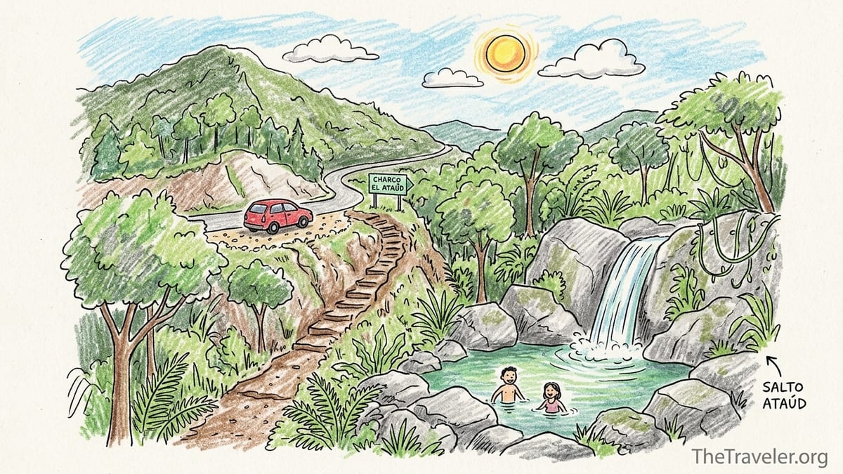
Most navigation apps will recognize “Charco El Ataúd” or “Cascada Las Garzas” and drop a pin along PR‑522. On my trip the GPS pin was accurate within a few dozen meters, but it did not highlight the actual improvised parking area described by the environmental agency. Instead, it simply announced that I had arrived on a curve with vegetation closing in on both sides. I used landmarks mentioned in local travel accounts: a modest opening on the left side of the road when coming from town, with space for a handful of vehicles to pull completely off the pavement, and a partial glimpse of the upper cascade through the trees if you stop and look down.
Parking is extremely limited. When I arrived mid‑morning on a weekday, two compact cars were already tucked onto the gravel and dirt shoulder. A third vehicle parked partly in the traffic lane, which felt unsafe given how fast some drivers take the curves. On a busy weekend or holiday this tiny improvised lot can fill quickly, leaving latecomers to make questionable parking decisions. There are no painted lines, no attendant, no fee collection and no signage indicating official capacity. If you cannot park fully off the asphalt, it is wiser to leave and return at a quieter time.
Because PR‑522 is a rural mountain road, you should not expect streetlights or wide shoulders. In wet weather, potholes can hide beneath shallow puddles, and small rockfalls are not unusual after strong storms. I would not recommend attempting the drive in a very low‑clearance rental car at night if you are unfamiliar with Puerto Rico’s mountain roads. In daylight, with patience and attention, most drivers will find it manageable.
Finding and Assessing the Trailhead
Unlike a state forest recreation area with a large signboard and ranger booth, the trailhead for Charco El Ataúd is understated. The closest thing to a marker is the slight break in the roadside vegetation and a worn earthen entrance that drops away from the pavement. There were no official directional signs during my visit, no DRNA or municipality plaques and no posted rules. The only human touches were a faint footpath and, unfortunately, a couple of discarded beverage containers near the start.
Once you step off PR‑522 the contrast is immediate. The hum of the road fades and you are under the canopy of mountain forest within a few meters. The first portion of the path runs down a dirt and root staircase carved informally into the slope. In dry conditions these “steps” are straightforward, though uneven and occasionally taller than a standard stair. In muddy conditions, they can be slick enough that you want both hands free for balance. I saw no railings, ropes or installed support structures at any point along the way.
Trail descriptions online often describe this as a “short walk” or “easy access,” and in terms of distance that is true. The entire trail from the shoulder of PR‑522 to the main pool of Charco El Ataúd is only on the order of a few minutes’ walk and less than a quarter of a kilometer. The catch is the vertical drop. The state’s waterfall guide mentions a steep slope, and that matches reality. You feel the descent in your knees almost immediately, and the angle increases as you approach the sound of the falls. This is not a stroll suitable for people who are unsteady on their feet or uncomfortable with loose ground.
Because I had talked with other visitors who warned about mud “al final de la bajada,” I came equipped with closed‑toe shoes that could handle getting wet. That choice made a real difference once the path transitioned from dry soil near the road to damp, compacted earth closer to the river. Sandals without heel straps or very worn sneakers would be a liability here. Children who are used to hiking might find it fun, but younger kids or anyone who needs support on stairs will find the combination of slope and roots challenging.
Vegetation, Terrain and the Final Descent
The environment around Charco El Ataúd feels quintessentially central‑mountain Puerto Rico. As you descend, the vegetation closes over you in layers of ferns, vines and shade trees, with the faint agricultural scent that drifts up from coffee fincas elsewhere in Adjuntas after rain. The path cuts through this greenery, at times barely more than a corridor pressed into the hillside by years of passing feet. In a few sections the trail skirts tree trunks at awkward angles, forcing you to sidestep or duck slightly to stay on the main line.
Halfway down, you begin to glimpse the river canyon, a stone throat lined with gray and reddish rock, and hear the waterfalls more clearly. The last stretch is the steepest and most technical, with the ground giving way to a combination of rocky steps and dirt chutes that have been polished by water and soles. In some spots visitors have created side paths that look easier but actually lead to unstable ground near the edge of drop‑offs. Sticking to the main, more beaten route is safer even if it looks more eroded.
Those final meters are where the descriptor “moderate difficulty” from the official waterfall guide feels most honest. You are not climbing with ropes, but you are no longer simply hiking. You use hands for balance, test each foothold, and at one point I chose to descend backward, like a ladder, because the rock surface was damp from spray and shaded by overhanging foliage. Anyone comfortable with typical forest trails in Puerto Rico will likely manage this without trouble, but it is not the kind of place where you send a child down ahead of you without supervision.
At river level, the ground underfoot shifts again to rounded stones, some the size of grapefruits and others as big as small suitcases. These can rock and roll when you step on them. I saw no constructed viewing platforms, boardwalks, or steps cut into the rock. The lack of infrastructure preserves a wild feel but also demands that visitors move more slowly and look carefully where they plant their feet. This is especially important if you are carrying a backpack, cooler or camera gear that affects your balance.
First Look at the Waterfalls and Pools
Emerging onto the rocks at the base of Charco El Ataúd, the first impression is of a narrow gorge carved by decades of high water and seasonal floods. The waterfall system is tiered, with an upper cascade dropping into a smaller pool, which then feeds a taller fall into the main basin that people photograph most often. The Department of Natural and Environmental Resources lists the total height of Salto Ataúd at just over 13 meters, divided into these two principal drops, which matches what you see on site: not a single dramatic plunge, but a graceful, stepped flow.
On my visit the water was a translucent blue‑green. In calm corners near the sides of the pool I could see submerged rocks a couple of meters down, while the center faded to a deeper color that hinted at significant depth. Local accounts speak of depths greater than 10 meters in the main pool under ideal conditions, and it is easy to see why thrill‑seekers are tempted to jump from ledges and tree branches. The smooth rock walls rise on either side, mottled with algae where spray keeps them perpetually damp, and rise to a narrow rectangle of sky that frames the scene like a natural cathedral.
Comparing this reality to social media photos, I found the colors slightly less saturated than the edited images circulating on tourism flyers, but the overall composition was the same. The water is indeed clear on dry days, the pools do take on an almost turquoise tone when sunlight hits at the right angle, and the rock amphitheater is as dramatic as promised. On the other hand, the camera rarely captures the constant low roar of the falls or the echo that amplifies every shout and laugh in the canyon.
For visitors who prefer not to enter the water, there are several stable vantage points along the rockier right‑hand side (when facing the falls) where you can sit or stand and take in the view. These spots are slightly elevated above pool level, out of the direct spray, and allow you to enjoy the changing patterns of light on the water without committing to a swim. A short scramble further downstream offers another angle where the lower fall and the bowl of the main pool are both in view, ideal for photography or quiet observation.
Water Safety: Enjoying Without Jumping or Diving
Charco El Ataúd has a reputation among some locals as a place for cliff jumping and deep‑water swimming. Stories about people leaping from the rocky ledges or from branches hanging over the pool are easy to find, and older blog posts even boast about approximate depths. In person, however, it is impossible to reliably assess exactly how deep the basin is on a given day or what debris may have accumulated at the bottom after recent floods. The river carries logs, branches and rocks during high water, and there is no regular inspection or clearing crew.
For that reason, I do not recommend any form of cliff jumping, high diving or swimming directly beneath the falling water at Charco El Ataúd. The current at the impact zone of the main cascade can pull a swimmer off balance, and even confident swimmers can be disoriented by turbulence and spray. Additionally, the smooth rock ledges that serve as jump platforms when dry become dangerously slick when wet. A slip on the takeoff or landing zone could easily result in head, neck or spinal injuries.
What feels safer, and still deeply satisfying, is to treat Charco El Ataúd as a place for careful wading and surface swimming in the calmer parts of the pool away from the direct cascade. On my visit, a couple of small groups were content to sit on shallow submerged rocks along the edge, letting the cold water run over their legs. Others floated on the surface near the middle of the basin with simple flotation aids, always keeping a conservative distance from the whitewater at the base of the falls. Parents who brought children kept them in the shallows and within arm’s reach, which felt appropriate given the lack of lifeguards or formal safety infrastructure.
The rock slabs around the pool also offer non‑aquatic enjoyment. Stretching out on a dry patch of stone to feel the mountain sun while listening to the falls is a pleasure in itself. Just remember that these same rocks can become treacherous if a sudden rise in water sends thin sheets of flow over surfaces that were dry a few minutes earlier. Keeping your belongings higher on the bank, rather than at the very edge, will reduce the risk of losing them to an unexpected surge.
Facilities, Trash and the Reality of an Unmanaged Site
Travelers used to managed recreation areas with entrance gates and amenities will immediately notice what is missing at Charco El Ataúd. There are no lifeguards, no warning or instructional signs, no trash cans, no toilets, no picnic shelters and no maintained stairways. Everything from the descent to the river to the space around the pool owes its current shape to natural erosion and informal use rather than formal planning. The only infrastructure is the state road above and the improvised gravel shoulder that serves as parking.
This absence of facilities has both charm and drawbacks. On the positive side, the area retains a sense of wildness. The pool is framed by unbroken vegetation, with no concrete walls, handrails or viewing decks interrupting the scene. Birdsong, the sound of the falls and the occasional call of another visitor make up the soundscape. At the same time, the lack of basic services demands that visitors take more responsibility for themselves and for the site. You must pack out all your trash, including food wrappers and bottles, and you should arrive prepared for the complete absence of restrooms.
Unfortunately, even on a relatively quiet weekday I saw evidence that not everyone follows leave‑no‑trace principles. A few plastic bottles and a discarded charcoal bag sat half‑hidden among rocks near the waterline, and there were cigarette butts worked into the sandy patches close to popular sitting areas. It is a reminder that without municipal garbage collection or rangers handing out fines, the cleanliness of the place depends entirely on visitors treating it like the fragile mountain canyon it is.
If you are uncomfortable with this level of self‑reliance, or if you are traveling with people who need toilets, shaded picnic tables or formal security presence, you may be happier spending your swimming day at a managed alternative such as the facilities around Lago Garzas or one of the region’s paradores with pools and on‑site staff. Those options trade some of the raw beauty and seclusion of Charco El Ataúd for predictable comfort and services.
Weather, Watershed and the Risk of Sudden Flooding
One of the most important safety realities at Charco El Ataúd is something you cannot see from the rocks around the pool: the size and shape of the watershed feeding the Río Las Vacas and nearby Río Garzas. Rain that falls on slopes kilometers away, around Lago Garzas or the high ridges of Guilarte State Forest, can funnel into the river system and manifest at the falls as a rapid rise in water level, even if the sky directly above the pool is partly sunny.
Local hikers and swimmers talk about “golpes de agua,” sudden surges where a calm pool transforms in minutes into churning brown water. Videos shared informally show logs and foam sweeping through channels that on clear days look tranquil and inviting. This is not a theoretical risk. The steep topography of Adjuntas accelerates runoff, and the rock canyon at Charco El Ataúd acts like a bottleneck for flow. There are no upstream dams or control structures specifically protecting swimmers here from storm pulses.
To reduce the chance of being caught in a rising river, I approached the visit with the same caution I would use in other high‑risk canyons. I avoided days when significant rain was forecast for any part of central Puerto Rico. I checked the radar in the morning and again before leaving town, paying close attention to cell clusters building over the highlands. Once at the river, I watched for subtle signs: how wet the high‑water marks on the rock were, whether there was fresh debris perched in branches above the current waterline and how much foam or organic matter the water was carrying.
If you see the water begin to turn murkier, notice a sudden increase in floating leaves and sticks, or hear the pitch of the falls rise, treat those as early warning signs and move to higher ground immediately. Do not wait for a visible wall of water. Because there is no siren system or ranger closing the area, each group at Charco El Ataúd is effectively its own safety officer, responsible for making conservative decisions based on the full upstream weather picture, not just the sky overhead.
Crowds, Atmosphere and Comparison with Lago Garzas
The human atmosphere at Charco El Ataúd shifts dramatically depending on day and time. On my weekday morning visit, I shared the entire canyon with two small groups: a pair of friends quietly taking photos near the edge and a family with older children who swam for about an hour before leaving. Conversation was low, music was absent and the dominant sound was the water itself. In that setting, the place felt almost contemplative, a pocket of solitude within easy reach of town.
Locals describe a very different scene on sunny weekends and holidays, especially in summer. Arrivals begin mid‑morning and by midday the improvised parking along PR‑522 can be full. Groups carry in coolers, portable speakers and inflatable floats. The pool becomes a lively social space where people take turns edging closer to the falls, line the rocks with towels and treat the canyon as an informal riverside party. While that can be enjoyable if you are in the mood for a crowd, it also raises noise levels, increases trash pressure and further reduces any sense of remoteness.
Compared with the atmosphere around Lago Garzas, the contrast is marked. The reservoir area, used for fishing and surrounded by forest and occasional facilities like bathrooms and designated picnic zones, feels closer to a traditional recreation area. There are clearly defined access points, some degree of oversight by agencies or concessionaires and a mix of families, anglers and hikers spreading out along the shore rather than clustering at a single swimming hole. You can still find corners of relative quiet there, but the experience is more structured.
If your priority is a managed environment with predictable amenities, Lago Garzas or the picnic areas near Guilarte State Forest’s ranger station will likely be more comfortable. If what you want is the sensation of being enveloped by rock and water, immersed in one dramatic scene where the only built element in sight is the faint line of the road far above, then Charco El Ataúd delivers that in a concentrated dose, at the price of accepting higher personal responsibility and less certainty.
The Takeaway
Charco El Ataúd turned out to be both as beautiful and more complicated than its social media reputation suggests. The short but steep descent from PR‑522, the improvised parking, the absence of formal facilities and the reality of rapid water‑level changes mean that this is not a casual roadside stop where you wander down in flip‑flops for a quick dip. It is a small but serious outing that calls for sturdy footwear, weather awareness and a willingness to say no to risky behaviors like jumping or swimming directly under the falls, no matter what you have seen others do online.
What made the place memorable for me was the way the canyon narrows around the main pool, framing the waterfall in a tower of rock and foliage. Sitting on a dry slab of stone, watching late‑morning light turn the surface from green to cobalt, I could see why locals speak of it as one of Adjuntas’s natural treasures. There is a sense of intimacy here that is different from broader river bends or wider lakes. The sound of the water, the coolness of the air and the reflections on the rock create an atmosphere that invites you to linger.
At the same time, a few aspects of the experience disappointed me. The scattered trash near the waterline undercut the feeling of pristine nature, and the total lack of signage about flood risk or safe behavior felt like a missed opportunity for basic public safety messaging. Even a simple board at the road describing the steep trail, the danger of sudden rises and the need to pack out waste could help align expectations. The tiny roadside parking area, with cars sometimes encroaching into the lane, also raises questions about long‑term sustainability if visitation continues to grow.
Would I return? Yes, but on carefully chosen days: dry weather in the wider region, early hours to avoid crowds and always with a conservative mindset about how close to get to the falls and how long to stay if I saw any changes in the water. If I were traveling with small children, older relatives or anyone who needed accessible facilities, I would likely choose a more formally managed swimming or recreation area instead, such as the shores of Lago Garzas or a parador pool near town. Charco El Ataúd is best approached as a wild mountain pool that rewards preparation and caution as much as curiosity.
FAQ
Q1. Is access to Charco El Ataúd currently legal for the public?
Based on state environmental documentation and recent local use, pedestrian access from PR‑522 is recognized and commonly practiced, though the spot is not a developed park and visitors must respect the area, avoid blocking the road and follow leave‑no‑trace principles.
Q2. How difficult is the trail from the road to the waterfall?
The trail is short in distance but steep and uneven, with dirt steps, roots and a final rocky descent that requires using your hands for balance. Most fit visitors manage it, but it is not ideal for people with mobility limitations or for very young children.
Q3. Can I rely on GPS alone to find the trailhead?
Navigation apps will usually take you to the right stretch of PR‑522, but they do not clearly mark the small improvised parking area or the unmarked trail entrance. It helps to watch for the roadside pull‑off and listen for the sound of the waterfall rather than depending only on the digital pin.
Q4. Are there lifeguards or safety signs at Charco El Ataúd?
No. There are no lifeguards, warning boards or safety ropes. This is an unmanaged river site where each group is responsible for judging conditions, supervising children and making conservative choices around the water.
Q5. Is it safe to jump from the rocks or trees into the pool?
I do not recommend any cliff jumping or diving. Pool depth and submerged hazards change with floods, and the takeoff rocks can be extremely slippery, so serious injuries are a real risk even for strong swimmers.
Q6. What facilities should I expect at or near the site?
There are no toilets, changing rooms, trash cans, picnic tables or official parking lots. You should arrive self‑sufficient, pack out all your waste and plan restroom stops in town or at other recreation areas with services.
Q7. How can I judge whether river conditions are safe on the day of my visit?
Check weather forecasts and radar for the broader central mountain region, look at the color and level of rivers and creeks on the drive in, and avoid visiting during or shortly after significant rain. At the pool, watch for sudden changes in water color, speed or debris.
Q8. What footwear and gear are recommended for the trail and pools?
Closed‑toe shoes with good grip, such as sturdy sneakers or water shoes, are best for the steep, rooty trail and slippery rocks. Bring a small backpack instead of loose bags so your hands remain free for balance, and pack a dry bag if you are carrying electronics.
Q9. How crowded does Charco El Ataúd get, and when is it quietest?
Weekends and holidays, especially in summer, can be busy, with limited roadside parking and groups with music and coolers. Early mornings on weekdays are typically quieter, offering more solitude and easier parking.
Q10. How does Charco El Ataúd compare to visiting Lago Garzas or a managed recreation area?
Charco El Ataúd offers a wilder, more intimate canyon setting with no facilities and higher personal responsibility. Lago Garzas and managed forest recreation areas provide more infrastructure, such as parking, bathrooms and designated picnic sites, but lack the same dramatic waterfall pool experience.