
High above Sandown Bay on the Isle of Wight, Culver Down looks today like peaceful open grassland, edged by white cliffs and seabirds wheeling on the wind. Yet beneath this calm surface lies one of the island’s richest military landscapes. From Victorian forts that never fired a shot in anger to secret radar stations guiding night fighters over the Channel, Culver Down has spent more than a century at the sharp end of Britain’s coastal defences. For travelers who like their sea views mixed with stories of spies, signalmen and soldiers, this headland is an open-air history book.
Culver Down: A Quiet Headland With a Heavy Past
Standing on Culver Down today, it is hard to imagine that for decades much of this headland was off limits, fenced and guarded as military land. The down is the eastern tip of the Isle of Wight, rising to around 100 metres and dropping in dramatic chalk cliffs to the sea on the Sandown side. These cliffs, together with the sweeping views over the Solent and the English Channel, made Culver a natural lookout long before the age of radar or artillery.
The name “Culver” itself likely comes from an Old English word for dove, a reminder that this was once known more for nesting birds than guns. In the nineteenth and twentieth centuries, though, Britain repeatedly turned this quiet pasture into a front-line vantage point. Successive generations of forts, gun batteries and electronic listening posts were built here to watch the sea approaches to Portsmouth and Southampton, key naval and commercial harbours just across the water.
For modern visitors, this layering of history is part of the attraction. Within a short circular walk you can pass a Victorian Palmerston fort, early twentieth-century gun emplacements, the ghost traces of radar masts and the site of a First World War wireless station, all within sight of families picnicking by the monument and paragliders riding the thermals above the cliffs.
Because the public land on the headland is now managed for conservation as well as heritage, you will see grazing cattle and rare chalk grassland plants alongside crumbling concrete and brick. It is a place where wildflowers reclaim gun pits, and where interpretation boards quietly describe one of the most technologically sophisticated defence networks of the Second World War.
Victorian Fears and the Age of Palmerston Forts
Culver Down’s modern military story begins in the mid nineteenth century, when Britain feared invasion from across the Channel. During the 1860s, under Prime Minister Lord Palmerston, an enormous programme of coastal fort building transformed key harbours and channels around the country. On the Isle of Wight this meant a ring of new forts and batteries intended to protect the eastern approaches to the Solent from a French fleet.
On the crest of the ridge behind Culver Down stands Bembridge Fort, a hexagonal work dug deep into the chalk with earth ramparts and a dry ditch. Completed in the 1860s, it was designed as the last-ditch strongpoint that would hold out even if enemy troops landed on the beaches below. Visitors who join one of the National Trust’s pre-booked guided tours can walk through underground magazines and vaulted casemates and see how this fort was built to house dozens of men, ammunition rooms and stores behind massive earth and brick protection.
Closer to the cliff edge, batteries such as Redcliff Battery and Yaverland Battery were constructed to cover Sandown Bay. Redcliff Battery, completed in 1863, stood dramatically near the cliff top south of Yaverland and west of today’s Culver Battery. It suffered badly from subsidence and coastal erosion, and by the late nineteenth century much of it had already been lost to the sea. Today, only scattered fragments of brickwork and concrete survive in the undergrowth, a reminder that the island’s geology has often had the last word on Victorian engineering.
Yaverland Battery, a little further west behind Yaverland Beach, had a more enduring life. Finished in the 1860s, it initially mounted eight 7‑inch Armstrong rifled guns, later replaced by larger 64‑pounder muzzle-loaders and eventually three 6‑inch breech-loading guns around 1900. Although now largely in private ownership and not generally open to the public, its long, low ramparts can still be picked out if you stroll the sea wall near the holiday park that occupies part of the old site.
Culver Battery: Watching the Channel Through Two World Wars
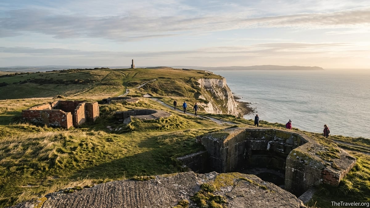
At the very end of Culver Down, on the cliff edge above Whitecliff Bay, lie the remains of Culver Battery. Built in the early twentieth century and completed around 1906, this was part of a modernised coastal defence line that replaced or supplemented the earlier Palmerston works. Whereas the Victorian guns had been designed to fire solid shot or simple shells at wooden or lightly armoured ships, Culver Battery was intended to counter fast, steel warships approaching the eastern Solent.
In its heyday the battery mounted heavy guns in open emplacements, protected by thick concrete and earth ramparts. Below the surface were magazines for shells and cordite charges, linked by narrow corridors and shell hoists. During the First World War the site was closed to civilians and heavily guarded. Local oral histories describe the down alive with uniformed men, with searchlights sweeping the bay at night and warning shots occasionally fired when trawlers or small craft strayed too close to the exclusion zone.
By the outbreak of the Second World War, Culver Battery had again been updated. The big coastal guns were modernised, anti-aircraft positions were added and the headland became a key node in a defence web that included Sandown Fort, Nodes Point and other nearby sites. If you visit today you can still walk around the concrete gun pits and look down over the vertical white cliffs to the water where enemy ships would have been picked out and engaged.
Information panels installed near the ruins help you visualise the wartime scene: ammunition trolleys rattling along rails, the deafening report of the guns echoing across the bay, and soldiers peering through rangefinders at silhouettes on the horizon. On a clear day you can see across to the Sussex coast, the same waters where convoys once formed up under armed escort before heading for the Atlantic or, later, for Normandy.
Signals in the Sky: Wireless Experiments and Radar Masts
Well before radar, Culver Down played a role in early radio communication. During the First World War a wireless station was established here to experiment with long-range signalling and to monitor enemy transmissions. The combination of height and open aspect made the headland an ideal spot for antenna masts and receiving equipment. Today there is little obvious to see of this phase beyond subtle earthworks and the occasional concrete footing, but local heritage walks still refer to the “wireless station site” as a key stop.
The Second World War brought a far more sophisticated network of electronic defences to the south coast. Across the country, tall steel transmitter masts and receiver towers were built as part of the Chain Home radar system, which could detect incoming aircraft tens of miles away. On the Isle of Wight, the main long-range radar installation was at Ventnor on the south coast, while a Chain Home Low station on nearby Boniface Down helped detect low-flying aircraft attempting to slip under the main radar’s coverage.
Culver Down itself hosted radar and searchlight installations that complemented these systems. Along the clifftop and around Culver Battery, rusted metal anchor rings set in concrete blocks can still be found among the grass. These once helped secure wartime masts and guy wires for smaller radar and communications aerials. For walkers today, they appear as curious industrial relics halfway between archaeology and sculpture.
Visitors interested in radar history often combine a walk on Culver Down with a trip by car or bus to the remains of the Ventnor radar station, where wartime bunkers and later Cold War structures survive on the hill above the resort. Taken together, they give a sense of how the Isle of Wight formed a radar picket line stretching from the Channel up the east coast, feeding information to RAF command centres that directed fighter squadrons during the Battle of Britain and beyond.
Gunfire, Blackouts and Local Wartime Life
During both world wars Culver Down was more than a map symbol. It was a living workplace for hundreds of men and women, and its presence shaped daily life in the villages around Sandown and Bembridge. Old photographs and local museum exhibits show columns of soldiers marching up the down, mules or traction engines hauling supplies, and clusters of Nissen huts providing barracks and workshops along the access track.
In the Second World War, blackout rules meant that the only lights allowed on the headland at night were strictly controlled beams from searchlights and the muted glow from instrument panels in observation posts. Residents in Sandown and Yaverland grew used to the sudden, bone-shaking boom of practice firing from Culver Battery, sometimes rattling windows in houses along Culver Parade. Contemporary accounts describe children collecting spent shell cases as curiosities, and farmers coordinating grazing around gunnery schedules.
There were risks as well as routines. The Isle of Wight lay directly beneath Luftwaffe flight paths to Portsmouth and Southampton, and radar and gun sites made obvious targets. Although the heavy bombing fell elsewhere, local papers of the time record sporadic raids, and gunners at Culver were expected to engage low-flying aircraft as well as ships. The concrete surrounds of some surviving positions on the down still bear shrapnel scars and later reinforcement work.
Travelers with an interest in social history will find that local churches, pubs and village halls keep traces of this intense period. The Culver Haven Inn, near the car park at the top of the down, retains photographs and stories of wartime regulars among its décor, while small exhibitions in Sandown and Bembridge museums often feature Culver’s forts and radar as part of wider displays about the island’s home-front experience.
Walking the Forts and Finding the Traces Today
Exploring Culver Down’s military history today is straightforward, provided you bring sturdy shoes and allow time to follow the waymarked paths that thread the headland. Many visitors start at the top car park near the Culver Haven Inn, from where you can immediately see the Yarborough Monument, a tall stone column commemorating a nineteenth-century local aristocrat and naval officer. From this vantage point, a loop of a few kilometres takes in most of the key sites.
Heading east, the path leads towards the cliff edge and the remains of Culver Battery. Here you can walk through the old gun emplacements, peer into the roofless magazines and imagine the guns that once pointed out to sea. Interpretation boards installed by local heritage groups help you decode low earth mounds, narrow ditches and circular concrete pads that might otherwise look like random lumps and bumps in the turf.
Continuing around the headland, the cliff-top path gives sweeping views over Whitecliff Bay and its sandy beach far below. This is a good spot to appreciate why military planners feared an enemy landing here. The sand shelves gently into the sea, offering a practical beachhead, while the high ground of Culver would provide any occupier with a ready-made lookout. Today, instead of troop barges, you are more likely to see kayakers, small yachts and families with windbreaks lining the shore in summer.
For a longer walk, you can follow the National Trust’s fortifications trail along the ridge towards Bembridge Fort and the inland side of Bembridge Down. This route takes you past more subtle surviving features, such as War Department boundary stones and the occasional concrete plinth from radar or signal masts. There are no entrance fees for walking the open downland, but guided tours inside Bembridge Fort typically run on selected days in spring and summer, and are worth booking ahead if you want to see its interior casemates and gun floors.
Practical Tips for Visiting Culver Down’s Historic Sites
Visiting Culver Down is easiest with your own car, though local buses run to Sandown and Bembridge from where keen walkers can approach on foot. From Sandown, the climb up from the seafront via Culver Parade and the coastal path is steep in places and can be muddy after rain, so waterproof footwear is recommended. The road to the top car park is narrow with passing places, and in peak summer or on sunny bank holidays the small parking area can fill quickly, so arrive early in the day or later in the afternoon if you prefer a quieter experience.
Weather on the exposed headland can change quickly. Even in late spring a warm afternoon in Sandown can translate to a brisk, gusty wind on the cliffs, so bring an extra layer and avoid standing too close to unfenced cliff edges. In winter, low cloud and drizzle can roll in from the Channel, giving the downs a distinctly atmospheric feel but making radar masts and forts seem even more ghostly in the mist. Always stay on waymarked paths, respect livestock and keep dogs under close control around grazing areas.
Interpretation boards around Culver Battery and along the main path provide enough information for a self-guided visit, but if you are particularly interested in forts and artillery, consider timing your trip to coincide with an open day at Bembridge Fort. These events usually include knowledgeable volunteer guides who can explain how Culver’s batteries fitted into broader Solent defence plans, and may show period photos or shell examples. Check locally on the island for current opening arrangements and any special walks that highlight the radar and wireless history of the downs.
Facilities on the headland itself are limited, which helps preserve its wild character. The Culver Haven Inn offers meals, drinks and toilets, and in high season an ice cream van sometimes appears near the car park, but there are no formal visitor centres or ticket offices. For more detailed background, many travelers stop in at small local museums in Sandown or at heritage centres elsewhere on the island, where displays on coastal defences often give extra context before or after a walk on the down.
The Takeaway
Culver Down is one of those rare places where a short hike delivers both big views and big stories. From the nineteenth‑century anxiety that produced the Palmerston forts to the cutting-edge radar networks of the Second World War, this quiet chalk headland has repeatedly been drawn into global conflicts. For the historically curious traveler, every concrete ring and eroded brick wall tells part of a tale spanning more than a hundred years of fortification.
Yet despite its martial past, the down today feels open and inviting. Skylarks sing above old parade grounds, wildflowers grow in abandoned gun pits, and walkers share the paths with local dog‑owners and families on weekend outings. Taking time to explore Culver’s forts, radar traces and wartime stories adds depth to any visit to the Isle of Wight, transforming a simple coastal viewpoint into a memorable journey through Britain’s defensive imagination.
FAQ
Q1. Where exactly is Culver Down on the Isle of Wight?
Culver Down sits between Sandown and Bembridge at the eastern tip of the Isle of Wight, forming the headland above Sandown Bay and Whitecliff Bay.
Q2. Can I visit Culver Battery and the old forts for free?
Yes. The downland and the ruins of Culver Battery are freely accessible on established footpaths, though some nearby Victorian batteries are now on private land.
Q3. Is there still any radar equipment on Culver Down?
No operational radar remains. What you see today are subtle traces such as concrete pads and metal anchor points where wartime masts and aerials once stood.
Q4. How long does it take to walk the main historic circuit?
A relaxed circular walk from the top car park taking in Culver Battery, the monument and key viewpoints typically takes between one and two hours.
Q5. Are guided tours available that explain Culver Down’s wartime history?
Guided tours inside nearby Bembridge Fort are offered on selected days, and occasional local guided walks focus on Culver’s forts and communications sites.
Q6. Is Culver Down suitable for families with children?
Yes, if children are closely supervised, especially near the unfenced cliff edges and in uneven areas around the old gun emplacements.
Q7. What is the best time of year to visit Culver Down?
Late spring to early autumn offers the best combination of longer daylight, wildflowers on the downs and generally more settled walking conditions.
Q8. Can I combine a visit to Culver Down with other wartime sites nearby?
Yes. Many visitors also explore Sandown’s seafront defences, Bembridge Fort, and, by car, the radar remains at Ventnor on the south side of the island.
Q9. Are there any facilities or cafés on the headland itself?
There is a pub close to the top car park that offers food and drink, but no formal visitor centre, so bring water and snacks for your walk.
Q10. Is Culver Down accessible by public transport?
Public transport can take you to Sandown or Bembridge, from where you can walk up to the downs, though the final approach involves a steep climb.