
Culver Down is one of those rare coastal viewpoints that quietly outperforms its own reputation. Perched above the sweeping curve of Sandown Bay on the Isle of Wight’s east coast, this chalk headland blends big skies, open downland and far-reaching sea views with a rich seam of military history and accessible walking. For travellers deciding where to spend limited island time, Culver Down consistently rewards the effort with some of the finest coastal panoramas anywhere on the island.
A Headland Perfectly Placed Between Sea and Solent
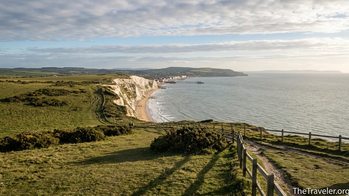
Stand on Culver Down on a clear day and the geography of the Isle of Wight suddenly makes sense. To the south, Sandown Bay arcs in a long, pale crescent as far as Shanklin, its 8‑plus miles of sand framed by low cliffs and seafront promenades. Inland, the green spine of the island climbs towards the Ventnor Downs, while to the north your gaze jumps over Brading Haven and Bembridge Harbour to the grey-blue strip of the Solent and the Hampshire coast beyond. It is this double aspect, towards both open English Channel and sheltered Solent, that makes the views from Culver Down unusually expansive.
The headland itself is a chalk downland plateau at the north-eastern end of Sandown Bay, above the small community of Yaverland. The public areas are largely cared for by the National Trust, and the land rises gently rather than dramatically. That gentle gradient is good news for visitors: you do not need to be a serious hiker to reach a big-sky vantage point. Walk just a few minutes from the car park by Bembridge Fort and you are already looking down onto the scalloped shoreline of Sandown’s esplanade and pier, tiny against the sweep of sea and cliffs.
Because Culver Down projects into the sea, the views shift subtly as you wander. From the stretch near the Yarborough Monument, you can turn your head from the dunes of Yaverland beach directly across the water to the white radar ball and masts at HMS Collingwood and the Spinnaker Tower in Portsmouth, then back again to the soft hills of the island’s interior. It feels like a natural balcony where you can take in both the bustle of the Solent shipping lanes and the quieter arc of holiday beaches in a single slow panorama.
For many visitors, this breadth of view is the main draw. You can watch ferries sliding in and out of Portsmouth and fishers working out of Bembridge while paddleboarders and swimmers dot the waters far below in Sandown Bay. The sense of scale is impressive but never overwhelming, helped by the open grassland underfoot and the way the land drops in stages to the sea rather than plunging vertically. It is an easy landscape to spend time in, whether you are walking a long-distance trail or simply strolling after lunch at the nearby downland pub.
Sandown Bay From Above: A Classic English Seaside Scene
One of the reasons Culver Down is so celebrated among local walkers is the way it shows off Sandown Bay. From the headland, the bay becomes a textbook English seaside scene laid out in miniature. You can trace the pale strip of beach from Yaverland, where families set up windbreaks near the sandstone cliffs, along to the classic pier and amusements of Sandown, then further to the quieter sands of Lake and Shanklin, where rows of beach huts glow softly in late-afternoon light.
The contrast between the wildness of the chalk grassland and the human detail below is striking. From above, the go-karts, cafes and arcades along Culver Parade merge into a thin band of colour. The Dinosaur Isle museum and the Wildheart Animal Sanctuary, both close to the seafront, are reduced to small geometric forms, reminders that this is an accessible family destination as well as a natural one. Visitors often remark that they only appreciate how long and lightly developed the bay really is once they have looked down on it from Culver’s upper slopes.
Weather makes a big difference, and part of Culver Down’s charm is how photogenic Sandown Bay looks in most conditions. On bright summer mornings you can stand near the cliff fence and watch sunlight glitter on the water while paddleboarders cut slow arcs across the bay. In early spring or late autumn, broken clouds cast moving shadows across the beach and town, and the pastel-coloured house fronts from Sandown to Shanklin pop against darker skies. Even on winter days, when a stiff easterly sends spray curling over the sea wall near Dinosaur Isle, the view from above captures the drama of waves hitting the long curve of shore.
For photographers, the vantage points are generous. A standard zoom lens is enough to capture both the detail of the pier and the broader sweep of the bay. Sunrise can be particularly rewarding in late spring, when the sun lifts over the mainland and sends a diagonal beam of light across the bay towards Shanklin. Many visiting photographers park near Bembridge Fort, walk ten minutes along the clifftop path towards Yaverland, and set up near the fence line that runs just inland from the cliff edge. From here, the curvature of the bay reads clearly, with foreground chalk grassland leading the eye down to sand and water.
To the North: Bembridge Harbour, Brading Marshes and the Solent
Turn your back on the sea at Culver Down and the view is just as absorbing. Looking north and west, you see the complicated waterways of Bembridge Harbour and Brading Marshes laid out like a map. At mid-tide, sandbanks and channels weave between moored yachts, while the low-lying wetlands behind glint with pools and reedbeds. This is one of the island’s most important wildlife areas, and from Culver’s height you can often spot the ghost-white flap of little egrets or the darker shapes of waders flocking across the mud.
Beyond the harbour lies the Solent, busy with commercial shipping, yachts and car ferries on their way to and from Portsmouth, Southampton and the smaller harbours of the mainland. On clear days the Spinnaker Tower stands out as a distinctive landmark, and at night a sprinkling of lights along the Hampshire coast reminds you how close you are to the urban south of England, even as the fields around you feel resolutely rural. The dual perspective is one of Culver Down’s great pleasures: you can enjoy open country underfoot while watching a working seaway and city skyline in the middle distance.
This northern aspect is at its most atmospheric at high tide, especially around sunset in late summer. The tidal inlets of Brading Marshes fill with water that mirrors the sky, and the twisting causeways and embankments of the reclaimed land become delicate lines in the landscape. From near the Yarborough Monument, the angle allows you to frame Bembridge windmill on its low hill, the marina at St Helens, and the distant outline of Portsdown Hill on the mainland, all in a single slow scan.
Practicalities also favour enjoying this view. The grass paths that loop around the top of the down are mostly level and firm in dry weather, so it is easy to wander from the southern clifftop to the northern edge without committing to a long hike. Visitors staying in Bembridge or St Helens often combine a harbour-side cafe breakfast with a late-morning bus or car trip up to the Downs, spending an hour roaming between viewpoints before dropping back down for an afternoon on the shore.
History in the Landscape: Forts, Monuments and Wartime Views
Part of what makes Culver Down’s coastal views so compelling is how thickly layered they are with history. The most obvious landmark is Bembridge Fort, one of the so-called Palmerston forts built in the 1860s at the height of fears about French invasion. Positioned on the highest ground of Bembridge Down, the fort was designed specifically because of its commanding views over Sandown Bay and the Eastern Solent, and later served as a command point for a string of coastal batteries during both world wars.
Today the fort belongs to the National Trust and opens for guided visits on selected days. Even when the heavy wooden door is closed, the exterior makes a striking focal point among the short turf and gorse. From the track that runs just south of the fort, you can imagine Victorian gunners scanning the same horizon where modern visitors now watch passing container ships and Isle of Wight ferries. Interpretation boards in the nearby car park explain how the fort’s position allowed visual control of both sea approaches, underlining why this spot has long been valued for its outlook.
A little way east, the Yarborough Monument rises from the down like a pale stone needle. Originally placed on the highest point of Bembridge Down and later moved to accommodate the fort’s construction, it now serves primarily as a viewpoint and waymarker. Visitors often pause here to read the inscription, then lean on the low wall and take in a full 180‑degree panorama encompassing Sandown Bay, Shanklin, the low cliffs of the mainland and, inland, the gentle ridges of the island’s central downs. The monument’s plinth is also a useful windbreak on breezy days.
Military history continues down on the cliffs themselves. The remains of coastal and anti-aircraft batteries along Culver Cliff hint at the headland’s strategic role in both world wars. From the clifftop, you can pick out gun emplacements partially buried in scrub, their concrete arcs now framing sea views instead of artillery. For visitors interested in coastal defences, it is easy to combine a walk on Culver Down with a trip to other nearby sites such as Sandown Fort and the surviving batteries that line the bay, creating a day where the scenery is inseparable from the story of how this coast was guarded.
Walking Routes That Make the Most of the View
One of the reasons Culver Down stands out among Isle of Wight viewpoints is how integral it is to several well-established walking routes. The Isle of Wight Coastal Path threads around the headland, meeting Culver Down Road near the Yarborough Monument, so anyone tackling the Shanklin to Bembridge or Bembridge to Sandown sections inevitably finds themselves on the Downs. From Yaverland, for example, the official path climbs steadily up the grassy slopes, gaining height quickly enough that within fifteen minutes you have an uninterrupted view across the bay.
The National Trust publishes a short “circumnavigate Culver Down” trail that loops for roughly two miles around the headland, starting from the car park near Bembridge Fort. It is an accessible circuit for most reasonably fit visitors, with wide grassy tracks and a mix of gentle undulations rather than severe climbs. Walkers follow chalk and turf paths that run safely inside the fenced cliff edge, passing through patches of gorse and wildflowers before looping back towards the fort. Because the route curves around the entire headland, even this brief walk offers shifting views: first over Sandown Bay, then north across Bembridge Harbour and the Solent.
For those wanting a fuller day out, the Yaverland to Bembridge circular walk combines a clifftop traverse of Culver Down with stretches of shore and inland paths across Brading Marshes. Starting near the car park by Yaverland beach, walkers climb to the Downs, follow the coastal edge above Whitecliff Bay and the Bembridge Ledge, then drop to the seafront and eventually turn inland via country lanes and the Bembridge Trail to return. This mix of high-level views, beach-level perspectives and quiet marshland offers a thorough introduction to the island’s east coast.
Even casual visitors who prefer not to follow a defined route can easily enjoy the views on foot. From the Yarborough Monument, a simple out-and-back wander along the clifftop fence towards Yaverland delivers a string of viewpoints within ten or twenty minutes of gentle walking. Because grazing livestock help keep the turf short in places, the paths often feel more like wide lawns than rugged trails. Sturdy trainers or walking shoes are usually sufficient in dry weather, though the chalk can become slippery after rain.
Changing Light, Seasons and Wildlife
The quality of Culver Down’s coastal views shifts wonderfully with the seasons. In late spring and early summer, the downland erupts with wildflowers: patches of thrift, cowslips and orchids pick out soft colours in the grass, and butterflies flicker along the paths. Standing at the cliff edge in May or June, looking out across Sandown Bay, you often have as much to look at under your feet as on the horizon. The vibrancy of the foreground makes the blue sweep of sea feel even more expansive.
Summer brings the clearest views, especially after a morning sea breeze has pushed haze inland. From the northern edge of the downs you can trace the line of the mainland coast from the low silhouette of Selsey Bill across to the high ground around Portsmouth and Southampton. The Solent is at its busiest, dotted with yachts, motorboats and the regular shuttle of the island’s car ferries. In the evenings, visitors sometimes bring a picnic or grab food from a pub or cafe down in Sandown, then drive up to watch the last light flatten into a broad band of colour over the mainland.
Autumn and winter reward those willing to brace cooler winds. On days when showers move in from the Channel, you can stand under a patch of blue sky while curtains of rain sweep across Sandown Bay in the middle distance. The contrast between dark cloud and white surf at the base of Culver Cliff makes for memorable photographs, and the bay often feels almost empty except for the distant movement of a dog walker on the beach or a lone surfer hoping for clean waves. On frosty mornings, the short turf of the downs sparkles underfoot, and views northwards over Bembridge Harbour take on a silvery, muted palette.
Wildlife adds another layer of interest. Skylarks sing above the grassland in spring, disappearing into the sky as you follow the paths along the cliff. Kestrels frequently hover over the slopes, using the updrafts along the cliff face, and in late summer swallows and martins sweep low over the ground to feed. Offshore, gannets and cormorants work the waters of the bay, while over the marshes you may spot birds of prey hunting. For many visitors, the combination of broad seascapes and immediate birdlife makes Culver Down feel alive even on days when the car park is quiet.
Reaching Culver Down and Practical Tips for Visitors
Despite its lofty views, Culver Down is relatively easy to reach. Most visitors arrive by car, following Culver Down Road east from the outskirts of Sandown or west from Bembridge. Near the top of the hill, a National Trust car park by Bembridge Fort serves as the main access point, with another smaller parking area closer to the head of the cliffs and the Yarborough Monument. Charges and opening times can vary seasonally, so it is sensible to check locally or via current visitor information before you travel, but as of recent seasons parking has typically been a modest day or hourly rate rather than city-centre prices.
Travellers without a car have options too. Regular Southern Vectis services run between Ryde, Sandown and Bembridge, and in recent years seasonal routes such as the Downs Breezer have offered open-top connections that include stops near Culver Down. Timetables change from year to year, but in summer it has often been possible to take a bus from Ryde up onto the downs, walk for a couple of hours, then continue by bus to Sandown or Shanklin for the beach. For up-to-date bus times, visitors should consult current island transport information shortly before their trip.
On the ground, facilities are limited but adequate. There are no large visitor centres at Culver Down itself, and toilets may only be available at nearby pubs or down in Sandown and Bembridge. Food-wise, many people combine a trip to the downs with lunch or coffee on Sandown seafront, where options range from simple cafes serving fry-ups and jacket potatoes to more contemporary spots offering seafood and vegetarian dishes. In Bembridge, small bakeries and delis provide good picnic supplies that can be carried up to the Downs for a meal with a view.
Footwear and clothing need not be technical, but conditions on the exposed headland can change quickly. Even on sunny days, the wind on the cliff edge can feel significantly cooler than down at sea level, so packing a light extra layer is sensible. The chalk paths may be firm and dry in summer but can turn greasy after rain, making good-soled shoes advisable. For families with pushchairs, the main track between the car park and the monument is usually manageable, although some side paths become narrow and rutted. Dogs are welcome but may need to be on leads in areas where livestock graze or near the cliff fence.
The Takeaway
Culver Down’s reputation among Isle of Wight locals and repeat visitors rests on more than just a pleasant walk. The headland delivers a rare combination of sweeping, 360‑degree views, accessible paths, visible history and genuine sense of place. From a single position near the Yarborough Monument, you can watch waves roll into a classic English seaside bay, trace ferry routes across the Solent, and pick out church towers and farmsteads in the island’s interior, all while standing on open grassland grazed for generations.
For travellers with only a few days on the island, including Culver Down in the itinerary makes sense. It pairs naturally with a morning on Sandown beach, an afternoon exploring Bembridge Harbour, or a longer section of the Isle of Wight Coastal Path. The headland’s views change with light and season, but what remains constant is the feeling of being on a balcony between land and sea, with the island’s geography laid out at your feet.
Whether you arrive on a breezy summer afternoon aboard a seasonal open-top bus, or drive up on a crisp winter morning when frost clings to the turf, Culver Down rewards the effort with wide horizons and a powerful sense of coastal drama. For many who know the island well, it is the place they return to when they want to be reminded, in a single glance, why the Isle of Wight’s landscapes are so special.
FAQ
Q1. Where exactly is Culver Down on the Isle of Wight?
Culver Down sits on the island’s east coast above Yaverland and Sandown, forming the northern headland of Sandown Bay and lying west of Bembridge and St Helens.
Q2. How do I get to Culver Down without a car?
You can take a regular Southern Vectis bus to Sandown or Bembridge, then either walk up via local footpaths or connect with a seasonal service, such as an open-top downs route when operating, that stops near the top.
Q3. Is there parking at Culver Down?
Yes, there is a National Trust car park close to Bembridge Fort and another small parking area near the Yarborough Monument. Charges and time limits can vary, so check current information before visiting.
Q4. Are the walks on Culver Down suitable for beginners?
Most of the main paths are gently graded and on short turf or chalk, making them manageable for reasonably fit beginners. A full loop around the headland is only a few miles and can be completed at a relaxed pace.
Q5. Can I visit Bembridge Fort when I am on Culver Down?
Bembridge Fort is open on selected days for guided visits, usually organised by the National Trust. Opening times change seasonally, so it is wise to check ahead and book if necessary.
Q6. What makes the views from Culver Down special compared with other island viewpoints?
Culver Down offers both south-facing views over Sandown Bay and north-facing views over Bembridge Harbour and the Solent, so you can see open Channel, harbour, wetlands and mainland coastline from one compact area.
Q7. Is Culver Down a good place for photography?
Yes, the elevated perspective over Sandown Bay, the monuments on the downs and the changing light over the Solent give photographers plenty of subjects, especially at sunrise, sunset and in mixed weather.
Q8. Are there places to eat or drink on Culver Down itself?
Facilities on the Downs are limited, so many visitors bring a picnic or combine their visit with cafes, pubs and restaurants in nearby Sandown, Yaverland or Bembridge.
Q9. Is Culver Down family-friendly?
Culver Down is popular with families thanks to its short walks, open grassy areas and big views. Parents should keep children away from the unfenced cliff edges and be aware of grazing livestock in some fields.
Q10. When is the best time of year to enjoy Culver Down’s coastal views?
Clear days in late spring, summer and early autumn usually offer the longest views, but winter can be dramatic, with powerful seas and changing light over Sandown Bay and the Solent.